Tag Archives: River Ravensbourne

Bellingham Lido – the ‘finest in London’

Catford has lost many sports venues over the years – notably the Greyhound Stadium, but also a velodrome, The Mount which was once home to Charlton Athletic, a former ground of London Irish, another smaller greyhound and midget car racing track as well as a significant cricket ground in Penerley Road. Another of these lost sporting venues was Bellingham Lido which opened in July 1922, it was one of the first in inner London and was apparently, at the time, the longest pool in London.  It was to open its doors during summer months for hardy swimmers for almost 60 years.  We’ll look at its development and demise, putting it in the context of other London lidos and open-air swimming facilities.

The backdrop to the development was the conversion of Bellingham from farmland to homes in the early 1920s.  Interestingly at the time, it was referred to as a ‘garden city’ a ‘new town of ten thousand’ – based on principles adopted in the building of Letchworth twenty years before (1).

While Bellingham was a London County Council (LCC) estate, some of the facilities in surrounding areas were provided the Borough Council, Lewisham. The site, for those not familiar with it, was a slightly awkward one between the Ravensbourne and the railway – about a hundred metres south of Bellingham station, access was over the river – the map below shows the location and layout, just post World War 2.

What was initially referred to as either an open-air swimming pool or an air pool, cost between £8,000 and £9,000 over a period of about 9 months.  In addition to providing swimming and bathing facilities for Bellingham ‘garden city’ and Catford it was used as a means of reducing local unemployment.  The work was carried out in-house by the Borough Council with 38 unemployed local men being used to build the pool (2).

The Mayor, Cllr C H Dodd (of the still trading Blackheath solicitors, who started life in Eltham Road), opened the pool describing it as ‘the largest and finest’ in London (3). Kathleen Dodd, his niece, and the Lady Mayoress, was the first to take the plunge into the cold water accompanied by the King sisters from Forest Hill Swimming Club (4)– she is pictured below (5); a swimming gala followed. 

It seems that the LCC watched its building with interest as around the time of its opening were asking for expressions of interest for building open air swimming pools form other Borough Councils (6).

While there is no evidence that she swam here it would be good to think that Hilda ‘Laddie’ Sharp, Hither Green’s pioneering Channel swimmer might have at least done some training here – she swam the Channel in 1928. 

Water initially drained into the Ravensbourne and there was no filtration plant initially built as part of the lido – water was drained late on Sunday mornings into the Ravensbourne and then refilled.  Presumably the quality of water was poor by the end of Sunday morning’s session.   A new filtration plant was agreed in late 1929.  Around £9000 was borrowed from the Ministry of Health for this along with increasing the ‘number of first and second class slipper baths’ from 31 to 57 at Ladywell and 12 to 25 at Bell Green.  The inspector noted ‘you will be quite clean in Lewisham.’ (7).

Whilst Bellingham may have been the first lido in what was then the old London County Council area it was by no means the first open water swimming in what we would now regard as London.  Several ponds that had been used for years for swimming, notably those on Hampstead Heath whose usage dates from around 1800 and the as well as the Serpentine soon after (8).  Outside what was the LCC area were already several open-air swimming pools in South London including Erith (built in 1906), Croydon (1909), Wimbledon (1913) along with Tooting Bec (1906) (9).

At their peak in 1939, the leader of the LCC Herbert Morrison described London as a ‘City of Lidos’ – there were a staggering 67 lidos open that year (10).   In neighbouring areas this included Brockwell, Danson Park, Eltham Park, Charlton, Bromley Southlands, Peckham Rye, St Mary Cray and Southwark Park (11).

In addition to issues around filtration there were serious problems with leakages – having to be refurbished over the winter of 1959/60 and opening a little late for the summer of 1960. (12). Fond memories of the lido from this era and a bit later often appear in Facebook threads in the various Lewisham reminiscence groups.

The lido closed in 1980 (13) – presumably as a result of the public expenditure cuts that most councils had to make in the early years of the Conservative Government led by Margaret Thatcher. 

It was a similar fate that beset most of the local lidos – Danson Park and Bromley both closed in 1980 too, although Bromley re-opened for a while in the mid-1980s, the last length was swum in 1987; Peckham Rye also closed in 1987, Southwark Park in 1989 and Eltham Park in 1990 (14) – its outline is still fairly clear though.

Locally only two remain – both built much later than Bellingham -Brockwell (1937) and Charlton (1939).  The latter had a major refurbishment a decade ago with Olympic legacy funding.  It re-opened as a heated pool in 2013 and is the perfect place to watch the sunrise on a cold winter’s morning.

Whilst now having no lido, Lewisham does now have open water swimming in Beckenham Place Park (pictured below) – it’s part of the conversion from an underused golf course to a well-used public park.  There was £440k grant funding from the Greater London Authority (a successor of the LCC) for both the pool and large scale tree planting, it opened in 2019. It is open year-round although booking is required.

As for the Bellingham Lido site, it was eventually replaced with the social housing of Orford Road, let from around 1990.

Notes

  1. Sydenham, Forest Hill & Penge Gazette 28 July 1922
  2. Brockley News, New Cross and Hatcham Review 4 August 1922
  3. ibid
  4. ibid
  5. from Bromley & West Kent Mercury 4 August 1922
  6. Forest Hill & Sydenham Examiner 4 August 1922
  7. Forest Hill & Sydenham Examiner 27 December 1929
  8. Simon Inglis (2014) Played in London (Swindon, English Heritage) p155
  9. ibid pp 158-159
  10. ibid p154
  11. ibid pp 158-159
  12. Sydenham, Forest Hill & Penge Gazette – 24 June 1960
  13. Inglis op cit p158-9
  14. ibid

Picture and Other Credits

  • The Ordnance Survey map is via the National Library of Scotland on a non-commercial licence
  • The photograph of the entrance is from the collection of Lewisham Archives – it is used with their permission but remains their copyright.
  • The postcard is from e Bay in July 2019.

The 1968 Lewisham Floods

Mid-September sees the 50th anniversary of the 1968 floods in Lewisham caused by the Rivers Ravensbourne, Quaggy and Pool all overflowing their banks as a result of two days very heavy rain on 15 and 16 September 1968.  The summer of 1968  had been one of the wettest on record, so the ground was already pretty much saturated causing large amounts of water to immediately run-off with large amounts draining into the local rivers.

So what caused the floods? A warm and very moist air front which had its origins in the western Mediterranean converged with a cool, moist one from the Baltic over south eastern England.  The fronts then moved very little for two days.   A broad area from the Thames Estuary to Hampshire received six weeks of rain, 75 mm (3” for you non-metric folk), during those two days.  A large area including south east London received double this – 150 mm (6”) – 3 months of rain in 48 hours.  On  Sunday 15 September alone, the Met Office noted that Bromley saw the heaviest rain with 129.5 mm (5.2”); rain in Bromley  ends up in flowing down the Ravensbourne and Quaggy to Lewisham. With this volume of rainfall it is not surprising that drainage systems failed to cope.

To understand the sheer scale of the flooding it is worth noting that the Quaggy, which typically had a depth of 15 cm (3”) at one point was over 5 metres deep in Lewisham (1). Traffic was unable to run at all along the main road between Catford and Loampit Hill as the entire area, built in the Ravensbourne flood plain was flooded (2).

The Ravensbourne

The Ravensbourne runs in a fairly flat valley all the way through Catford and Lewisham and there was flooding all the way along course – The Times photographed flooding on Southend Lane, close to Bromley Road where the usually hidden Ravensbourne crosses (3).  There was flooding too further upstream at Bromley South where the Ravensbourne burst its banks.

There were lots of memories on Facebook threads on this of using boats from Peter Pan’s Pond – originally a mill pond on the Ravensbourne (now the pond outside Homebase) to row around the area, including getting into the bar at the Tiger’s Head and generally playing in the flooded waters.

In nearby Watermead Road, flood waters reached 1.5 metres deep in places (as they did on Southend Lane) – houses there took a year to dry out and there was some looting after the flood waters receded.   A little further downstream is one of iconic pictures of the Lewisham floods – the Robertson’s Jam Factory which had the Ravensbourne immediately behind (on a Creative Commons via David Wright on Geograph).    

Unsurprisingly, a hundred metres further down Bromley Road, there was also flooding at the junction with Aitken Road (on a Creative Commons via David Wright on Geograph). Those with basement flats were particularly badly affected – in one on Barmeston Road the water went up to the ceiling.  

The volume of water coming down the Ravensbourne was augmented by the also flooded River Pool (see below) – the confluence is just south of Catford Bridge.  This meant that Catford Town Centre was under water.  There were memories on Facebook of free buses being laid on to transport people wanting to get from Stanstead Road to Brownhill Road, elsewhere refuse lorries did the same thing.

There was a ‘not entirely successful’ attempt to sail from Catford to Lewisham on a wooden garage door brought downstream on the Ravensbourne.  More appropriate forms of water transport were used in Ladywell Fields where an unknown kayaker paddled close to the railway bridge.

The extent of the flooding becomes apparent in the foreshortened by telephoto lens shot looking towards Ladywell Bridge from the around the ‘playtower’

While not shown in the picture there was a boat that ferried people across the worst of the flooding at Ladywell.  Marsala Road, parallel to the Ravensbourne, itself became ‘a fast flowing river’ with water levels inside houses rising to over a metre above ground level at one point.  There were Facebook memories of playing on a tractor inner tube in the flood water on the street. The ground floors in neighbouring Elmira Street were flooded too.

In Lewisham it seems that the flooding caused a crane to topple over – presumably on the Sundermead Estate that was being built at the time (4).

The Quaggy

From its entry into Lewisham at Chinbrook Meadows (and no doubt further upstream too) there was flooding along the Quaggy, Just outside the park in Marvels Lane, next to Sydenham Cottages as the Quaggy burst its banks.

Lee Green flooded, although probably not as badly as it had done in the past from snow melt in the early 19th century.  Manor Lane, where the Quaggy is bridged and Leahurst Road flooded too. There was flooding on Lee High Road and the parallel streets – with memories of submerged basements and flooded gardens around Eastdown Park – the photogrpah belwo shows the bottom of Dermody Road and the bridge over the Quaggy into Weardale Road.

On Lee High road itself the shops on Manor Park Parade (opposite the Rose of Lee, now Dirty South) had almost 2 metres of water in their basements).

At Lee Bridge water reached the top of the steps of the White Horse and there are rumours of paper money floating in the basement of the then Midland (now HSBC) Bank opposite, which were covered in a blog post on the last stretch of the Quaggy.

The bottom of the High Street flooded as the whole area around the Quaggy and Ravensbourne confluence was inundated – perhaps the most icon photograph of the floods are of the ‘Lewisham Lake’, it made the front page of the Daily Mirror but local people put on their wellies just got on with life as the photograph below outside the Odeon (formerly Gaumont) shows.

One of the largely culverted tributary streams of the Quaggy, Hither Green Ditch, seems to have flooded on Verdant Lane.

The Pool

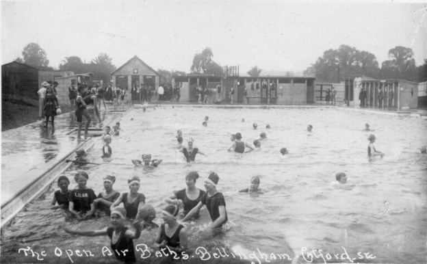
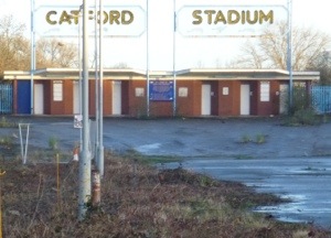
The Pool effectively forms in Cator Park in Beckenham from the confluence of The Beck, Chaffinch Brook (which certainly flooded) and the River Willmore (often known as Boundary Stream).   Unsurprisingly, the River Pool flooded too at, and below, Bell Green.  The photograph below is from Winsford Road, with the backdrop of Grangemill Road in Bellingham (on a Creative Commons via David Wright on Geograph) – the area flooded to the left is still open ground and known locally as Dog Field (after a very short-lived greyhound track that was once there).  The high waters washed away large amounts of coke from the gas works, off screen right, which was deposited on the allotments behind Dog Field.

A little further upstream the Pool overflowed near Bell Green making the bridge from Southend Lane impassable other than by boat

Pool River in Flood - 1968

Elsewhere in the South East

Given the extent of the weather front it wasn’t surprising that the flooding wasn’t an isolated issue for Lewisham, although it was one of the areas that was hit worst; large swathes of south east England were flooded with rail contact between London and Kent was being completely cut.   Edenbridge in Kent was completely cut off after the River Eden, a tributary of the Medway, burst its banks. 150 passengers on a diverted train from Charing Cross to Hastings stuck on the train for almost 12 hours at the station there (6).

The AA described the picture from above with only a little exaggeration –  ‘The whole of the area form Essex to the Sussex-Hampshire border was like a giant lake, with dozens of main roads and hundreds of secondary roads flooded.’ (7)

In days when mobile communication is the norm – landlines were the only means of telecommunications – over 78,000 (9), including many in Lewisham were down as the GPO were overwhelmed (8).  Still 28,000 of those out of action by 19th September (10)

In the days that followed the flooding spread as the storm water made its way down the Thames – East Molesey being particularly badly affected. (11)

The Immediate Aftermath

In the days after the flood before the water subsided the army were brought into deliver food to those cut off on upper floors (14). Shops had sales of tinned food without labels which became something of a lucky dip and town centre shops, such as Chiesmans, had flood damage sales.

Basements were pumped out – including the Rose of Lee (now Dirty South) and no doubt the shops opposite.

The Mayor of Lewisham had used his dinghy to ferry a few people around and investigate what was happening on the ground (lake?) himself whilst the area was flooded (11).  However, the then Tory run council was accused of “falling down” on its duties.  Some victims were paid up to £1600 from surpluses on funds set up following the Lewisham Rail Crash in 1957 and the Hither Green one of 1967 (12).  Some were rehoused by the council, but beyond that, other than giving people a bottle of bleach, there seems to have been little practical support for those families make homeless or having had possessions ruined – particularly those who weren’t insured.  After the floods subsided, carpets were hung over fences and other possessions left outside in the hope that they would dry out and recover …..and then there would have been the smell as they probably didn’t properly dry out.

Lewisham’s population has changed a lot since 1968, many of the areas alongside the rivers have seen gentrification and those with better paying occupations move in.  It is easy to forget the changes in the last 50 years – ‘Employers, Managers and Professional Workers’ made up 34.5% of the adult population in last census in 2011 – in the census immediately after the floods in 1971 only 10.5% fell into this category.  Census employment categories have changed a lot over time but it is worth remembering that manual work still dominated in the area at the time of the floods.  Household contents insurance was rarer, and then, as now, poorer households didn’t have it.   While overall household insurance costs from the floods across south east England were estimated at £15 million (13), this would obviously not have taken into account those without.

There was little in the way of a Parliamentary debate about the floods – Parliament was in recess when the floods happened and seems to have moved-on by the time that the floods were debated in mid-October – in the Commons the focus was on farming and in the Lords, oddly on a telephone exchange in Cobham that was flooded for a couple of days.

Longer Term Changes

There was little change in approach to moving peak flows downstream, a continuation of plans that had been started on the River Willmore (Boundary Stream) in Penge and other local rivers of creating concrete banks and beds to move water on faster – sometimes referred to as ‘channelisation’.


This continued along parts of the Quaggy – notably between Grove Park and Eltham Bridge (see above); the River Pool between Bell Green and Catford had its meanders removed (left) and the concrete casing and straightening continued from its confluence with the Ravensbourne all the way through Catford, Ladywell and Lewisham (see below).

There were still occasional more localised flooding’s but the real downside of the concrete straight-jackets was that the lack of natural banks and beds meant that the rivers lost much of the plant and wildlife.

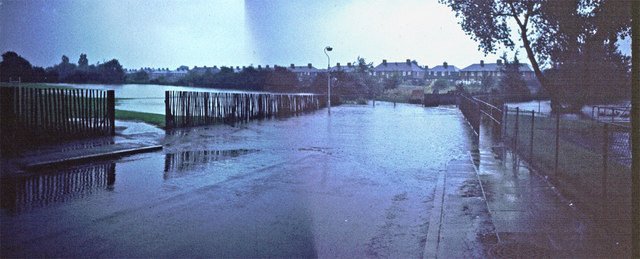
New approaches started to be developed from the late 1990s, with large scale flood water storage areas in Sutcliffe Park (above) and Weigall Road which hold peaks flows – much of this happening through work by QWAG, the Environment Agency and other local groups. Similar work is planned in Beckenham Place Park.   More natural, wider banks and meanders have been added and restored in several areas – notably in John Roan Playing Fields, Chinbrook Meadows, Manor Park and Ladywell Fields (below from late 2013) – these allow the rivers to hold more water in peaks, slow down flows and allow the return of plant and wildlife on banks.

Notes

  1. The Times (London, England), Tuesday, Sep 17, 1968;
  2. Ibid
  3. The Times (London, England), Monday, Sep 16, 1968; pg. 5; Issue 57357.
  4. The Times (London, England), Monday, Sep 16, 1968; pg. 5; Issue 57357.
  5. ibid
  6. The Times (London, England), Tuesday, Sep 17, 1968; pg. 1; Issue 57358. (796 words)
  7. The Times (London, England), Monday, Sep 16, 1968; pg. 1
  8. The Times (London, England), Tuesday, Sep 17, 1968; pg. 10; Issue 57358. (1129 words)
  9. The Times (London, England), Friday, Sep 20, 1968; pg. 2; Issue 57361. (376 words)
  10. The Times (London, England), Wednesday, Sep 18, 1968; pg. 1; Issue 57359.  (792 words)
  11. South East London and Kentish Mercury 19 September 1968
  12. The Times (London, England), Monday, Sep 16, 1968; pg. 1
  13. The Times (London, England), Monday, Sep 23, 1968; pg. 4; Issue 57363.
  14. The Times (London, England), Friday, Sep 20, 1968; pg. 21; Issue 57361.

Picture Credits

  • Most of credited within the text
  • The Ordnance Survey map of the Pool’s meanders is via the National Library of Scotland on a Creative Commons
  • The photograph of Marvels Lane is from Borough Photographs, used with permission of Lewisham Archives
  • The photograph outside the Odeon has appeared numerous times on social media, never credited – if you are the copyright owner do let me know so that I can credit you (or remove if you would prefer.
  • The remaining 1968 photos were copied by Emily Hay from Lewisham Archives and are used with the kind permission of both
  • The modern photographs are mine, feel free to use them, credited, for non-commercial purposes.

A massive thank you to Emily Hay both for the photos and talking with me about her childhood memories of the floods – it was really helpful and much appreciated.

A View From The Point

Time series of images make for interesting viewing – it is a technique that many have used, such as the Chilean-born photographer Camilo José Vergara who recorded changes in particular buildings over 40 years and fellow blogger Bobby Seal who recorded the same view at the same time of day over a year and created a video.

On Twitter, the Barnsley Bard, Ian McMillan, creates 140 character poetic ‘images’ of his (very) ‘Early Stroll’ of around 40 minutes, that includes a visit to the paper shop – it is one of the joys of twitter .

The Point is perhaps my favourite view of London, it was the starting point for my first post on Running Past  – there is an uninterrupted vista over the city in an arc from around Battersea in the south west to glimpses of Orbit in the Olympic Park to the north east.

image

Oddly, it isn’t a well-known panorama, often I am the only one admiring; it doesn’t have the impressive Inigo Jones foreground of the view a little further around the escarpment in front of the Observatory which draws in the tourists.

copy-image1.jpg

It is a place of solitude, despite the proximity of the often pollution laden A2, frequently the only sounds are the birds in the quite dense shrubbery that flanks the viewpoint along with the more distant rumble of the DLR.

In places, the horizon is truncated by the hilly landmasses of north London – Hampstead Heath and Highgate along with their relatively near neighbour which Alexandra Palace sits atop.  All the tall London landmarks are visible – St Pauls, Telecom Tower, the ‘Cheese Grater’, the ‘Walkie-Talkie’, the ‘Shard’, the ‘Eye’, and the tops of the Canary Wharf towers – the number of stories depending on the level of pruning.

On a clear day the Wembley arch is visible in a way that the Towers never were – it sometimes glints in the sun – it is about 10 miles away as the crow flies; on a really clear day there are views beyond to what appear to be the tiny undulations of to what must be the Chilterns to the south and Harrow on the Hill to the north of it.

image

I first discovered the view from The Point on a run in the mid-1990s and have been frequently drawn back, although only started taking photographs a couple of years ago.   The camera can never pick the level of detail of an eye scanning the horizon – the clarity of the view on a frosty autumn morning or after a summer afternoon downpour are hard to replicate, particularly with a smart phone camera with no optical zoom.

Some of the changes would need a much longer time series of photographs to become apparent – most of the larger landmarks of the cities of London and Westminster have appeared in the time that I have been viewing – it is a gradual evolution of the view, almost imperceptible from visit to visit.  Over longer time periods the view has changed more – I bought a 1940s photograph of the view (taken slightly lower down the hill), while fascinating, its slightly blurry image is almost unrecognisable compared with those 70 years later, with considerable bomb damage around Deptford Creek.  Only St Pauls Deptford seems constant – its steeple particularly clear.

img_2875

The middle distance has evolved considerably – the Pepys Estate and other ‘regeneration’ schemes that have brought high specification private housing, but little genuinely affordable social housing, to the riverside and in the process have driven traditional Thames-side activities away from the waterfront.  Deptford Creek, the mouth of the Ravensbourne, around a mile away, is much altered – it is no longer visible but now seems lined with glass and steel, including the  impressive Laban Centre.  The changes are even greater to the north – when I first ‘discovered’ the view, 1 Canada Square was there but little else on the Isle of Dogs, the Barkantine Estate towers on the east of the ’Island’ were still fairly dominant, they are now dwarfed by everything around them.

There are lots of other changes too, which it is easy to forget.   Helpfully the viewpoint has a guide to the view provided by the old Greater London Council, which predated many of the now landmark buildings that dominate the skyline, less helpfully , most of the time those in charge of the grounds maintenance have allowed shrubs to block the view it described although an early January pruning has restored the view.

point3

Other changes are more obvious – seasons, weather, cloud cover, pollution levels, times of day and foliage growth.  The seasons make a surprising difference – the winter sun with its much lower angle casts a very different light to its midsummer counterpart – the former is clearer, brighter and crisper but the contrast is greater. My visits are often on a Sunday morning, more recently I have frequently laced up my running shoes in the afternoon. In the summer, I sometimes eschew the Wednesday evening ‘club run’ for a run nearer home – decisions that are often based around the timing of the sunset or the weather.

I only tend to visit in daylight, it is uneven under foot and ill lit at night, although there are exceptions, and rarely when it rains, although where there is a choice I would tend to avoid running in the rain and the phone stays firmly in the pocket.

image

But perhaps that is the key point, I am one of the variables, perhaps the single biggest influence on the series of pictures – it depends on me being there to be captured – it isn’t just the wet days, I may ‘skip’ the loop to The Point if I know the visibility is poor – the clarity of the view towards the spire of Our Ladye Star of the Sea on Crooms Hill from my emergence onto the Heath– is often the bellwether of adjustments to my run.  I also decide on the angle of the photograph, the amount of zoom, while my eye is drawn more towards the horizon, the lens is drawn west-north-west towards the City, towards the glimpses of the River.

image

The Sounds of Running

And the wind blustered …

Molly is called

Molly ignores

She continues to gently sniff and snuffle


And the wind blustered …

A woodpecker’s taps echo through the copse

The 8:08 from Catford brakes on its approach,

The bridge sighs and rattles

IMG_0816

And the wind blustered …

The confluential rumble of the merging of Pool and Ravensbourne

‘The Hipster’ misjudges his approach to the footbridge,

Mutters an apology


And the wind blustered …

‘Brompton Woman’ smiles and greets

A cackling-like call from moorhens scurrying across the path

The soft purr of a well maintained Giant’s Shimano


And the wind blustered …

The Pool gurgles and splashes under Boris’ bridge

The gentle pad of trainer on tarmac

Water caresses and gently shifts stones from the island of the now lost country seat

island

And the wind blustered …

The ferrous acceleration of the fast train just past Lower Sydenham

A cacophony of internal combustion

Bell Green


Today is an odd anniversary, 365 days since my neck was broken by a car travelling at around 35 mph that failed to stop on the pedestrian phase of a pelican crossing; I survived and recovered thanks to the National Health Service, a fantastic physiotherapist and a lot of hard work.  I wanted to mark the anniversary in some way, but I thought it better to use it to draw a line and move on rather than reflect on the year gone – I did that to a large extent anyway a few weeks ago in my Review of 2015.

For reasons I cannot fathom, one of the changes in me is that I have become much more aware of sounds. So it seemed appropriate to recognise and embrace that change and also to try something new here. The piece above is a series of sounds turned into words that I noticed along part of one morning’s run to work, along a path sandwiched between a railway and the River Pool that I share with cyclists and dog walkers – many of whom I know by sight, and several of whom I have ‘named.’  The overwhelming sound that morning was wind (other days it is birdsong and on return journeys often children) … until I got to Bell Green….

Reflections on the Rivers Ravensbourne & Pool

As I recover from an accident, I am still a while off running but my urban wanderings always seem to draw me back to my regular running routes.  

This week my still (slightly) short days at work have left me with time to follow the Rivers Pool and Ravensbourne from Sydenham back towards Lewisham.  It seemed slightly odd not running, but it gave a rather different perspective.  

Monday’s leaden skies saw me focus on the both the mural under the bridge near Bell Green – which was painted a couple of years ago, but I have never stopped and looked at – plus the more industrial and metallic elements of the route.  


Friday morning should have seen a partial eclipse and, given the juxtaposition of it with the vernal equinox, meteor showers and the aurora borealis being visible in parts of Britain, it would have had our ancestors heading for the henges and hills.  Sadly it was just 50 shades of grey in London (photo by @weareblackheath).  


The afternoon though was almost perfect spring weather – clear, mild and sunny.  I niddle-noddled along paths alongside the river, which I don’t usually use – tending to stick to the smooth tarmac – to save time on my run to work and to make intervals or tempo runs safer on the run home; it made a wonderful change.


I also spotted several reflections, which at a faster pace I would have undoubtedly missed.


Any wanderings of a fluvial flâneur would not be complete without the sight of a semi-submerged, upturned shopping trolley, one was spotted in the reflection of the Riverside Building of Lewisham Hospital – an odd cocktail of drugs on a past stay there left me convinced of the presence of dayglo squirrels in the adjacent Ladywell Fields. 


Sadly only grey squirrels were visible this week, and alongside the rivers a green woodpecker, a heron and the iridescent blur of a kingfisher was seen a couple of times.  It was two spottings of different wildlife that oddly pleased me more – Lewisham Natureman stags – one by the Ravensbourne under the road bridge in Catford, the other shyly hiding in the corner of the former Ladywell Leisure Centre site as I went from the Ravensbourne to the Quaggy catchment.


The Four Spectres of the Victorian Poor

In 19th century London the four spectres of old age, accident, sickness and unemployment haunted the poor, for it led, almost inevitably, to applications for the Poor Law, and in many areas this meant the workhouse. While many have disappeared under bulldozers, often to make way for new hospitals a few of the old buildings remain.

There are two within a few hundred metres at opposite sides of Ladywell Fields on my regular runs along Waterlink Way. The Poor Law Unions that ran them were Lewisham and Bermondsey (St Olave) were unusual in that they provided mainly ‘outdoor’ relief – money, food, clothing or goods, given to alleviate poverty without the requirement that the recipient enter an institution.

On the western side of the Ravensbourne are the remains of the workhouse infirmary of the St Olave’s (Bermondsey) Union Board of Guardians.

20140124-184431.jpg

Opened in 1900 it had 812 beds for the elderly poor and infirm. It was later to have a variety of uses – a WW1 military hospital and what seems to have been a quite large scale children’s home.

20140124-184455.jpg

Much of the site has been cleared for housing, but the gatehouse, admin blocks (which are used by Lewisham Council) and magnificent water tower all remain.

20140124-184531.jpg

The Running Dogs of Catford

Work may at last be starting on redeveloping the old Catford Greyhound Stadium, there was certainly some activity on the fringes of the site this morning. I pass a couple of times most weeks on my regular runs alongside the Ravensbourne through Ladywell Fields towards the Pool and Waterlink Way. The rivers are about as full as I have ever seen them in 15 years running along the route.

20140117-201134.jpg
The stadium had its first meeting on 30 July 1932 with perhaps the most famous greyhound of all, Mick the Miller, being paraded around the track. It enjoyed three decades of success but its death knell, along with that for many other greyhound tracks, came in 1961 with the legalisation of betting shops. The decline was slow but the stadium finally closed its doors in 2003.

While there was some talk of listing parts of it, the stadium was partly destroyed by fire in 2005 and subsequently demolished. All that remains is the large metal sign and turnstiles and a vague outline of where the track once was.

20140117-202006.jpg

20140117-202015.jpg

There are some great photos of the stadium prior to the fire on the excellent Derelict London website

Barratt homes are meant to be developing 589 homes plus a community centre and a few shops near the stations starting this year with the final home going up in 2017. There were plans to start work but the post 2008 economic downturn seems to have put plans on hold.

The other aspect of the racing that has disappeared from the area are the greyhounds – whilst the stadium was open there were always a few dogs owned by local people or taken on as pets when their bibs were hung up; they were a common sight in Ladywell Fields – but one spied on Waterlink Way between Christmas and New Year was the first I have seen for ages.