Tag Archives: Wellmeadow Road

World War Two Damage on Springbank Road

There have been several posts in Running Past on World War 2 bombings and post-war reconstruction, many of these have been around V-1 and V-2 attacks such as those on Lenham Road, Lewisham Hill, along with a pair of Hither Green ones – Nightingale Grove and  Fernbrook Road.  More recently Running Past has covered the attacks that happened on three nights on their 80th anniversaries – the First Night of the Blitz of the as well as the post Christmas raids on the nights of 27/28 and 29/30 December 1940.  We turn our attention now to the more widespread damage on Springbank Road caused through a variety of attacks. 

Key: black=total destruction, purple=damaged beyond repair, dark red=seriously damaged (doubt if repairable), light red=seriously damaged (repairable at cost), orange=general blast damage (non-structural), yellow=blast damage (minor), green=clearance area

The level and scale of damage becomes clear when looking at the London County Council Bomb Damage Maps pictured above (1) which shows that most of the houses in the street had some form of damage.  Rather than Springbank Road itself, Hither Green marshaling yards, behind the eastern side of the street, were one of the two main Luftwaffe targets in Hither Green during the Blitz, the other being the hospital (2). The damage was much greater to Springbank Road though than to the west of the railway. 

Large swathes of the street were mapped as red by the London County Council surveyors – ‘seriously damaged (doubt if repairable)’ or worse.  In reality, a lot more end up surviving the war than the map suggests.

The Air Raid Precautions (ARP) Service logs make for fascinating reading in terms of trying to work out what damage happened when in Hither Green and the extent of the damage.  However, as we’ve seen in relation the First Night of the Blitz as well as the post-Christmas raids, recording in the log was patchy at best with some high explosive and incendiary bombs only being recorded by the Fire Brigade and others, which were dealt with by local ARP Fire Wardens, were never recorded.

On the third night of the Blitz, on 9 September 1940, it is clear that 136 Springbank Road was hit.  What is less clear is whether this was a direct hit or the fallout from the bombing of the house behind at 51 Wellmeadow Road. This was the house was on the corner with Torridon Road and marked in black on the map above and was completely destroyed. This part of Wellmeadow Road was rebuilt after the War.  William Brown (83) and Alice Budd (56) died at 51 Wellmeadow Road that night. 

136 Springbank was less badly damaged, although it seems to have undergone some wartime or post-war rebuilding work as from the front from the variety of slightly different bricks were used.  One of the inhabitants was Mary Hutcheson – it was a large house that she shared with a couple – the Gallotts.   Mary was seriously injured in the bombing, although she lived for another 6 months before dying at St Alfege’s Hospital (later Greenwich) on 10 March 1941, aged 82. 

Elsewhere on Springbank Road, there was some serious damage further down the street with 213 to 225 completely destroyed. The date of this bombing isn’t clear as the attacks appear not to have been recorded in the ARP log (3).  Unlike 136 Springbank, no one was killed in the attack, although given the scale of the damage it would be surprising if there were no injuries.  213 to 225 (pictured above) were rebuilt as a mixture of Borough of Lewisham houses and flats after the war.  On the other side of the street, there was destruction and rebuilding too, but you have to look closely to see the differences compared with the original Corbett estate homes – the brickwork around the doors and windows is different and the homes are similar to replacement houses in Wellmeadow Rod, which we’ll cover below.

Elsewhere on the eastern side, homes got away with some more limited damage; there had to be re-building work at 211; while its next-door neighbour didn’t survive, the roof, chimneys and bay wall had to be re-built at 211.

There had were several nights during December 1940, notably that of 29/30, when the area on the other side of the railway had seen 1 kg incendiary bombs raining down.  Springbank Road escaped on those nights. However, three weeks earlier on the night of 8/9 December, there had been a similar attack over a slightly wider area – there were a trio of hits at just before 11:00 pm at the southerly end of Springbank Road – none of the repots had any indication of the extent of any damage or casualties.  It could have been the attack that destroyed 213 to 225, as the fire services will have been overstretched that night, although incendiary damage tended to be of a much smaller scale and often put out by wardens.

V-1 doodlebug attacks started to pepper the area from 16 June 1944 – in Hither Green and neighbouring areas, during the first week there had been attacks between George Lane and Davenport Road on 16 June; Lewisham Park the same day; Lewisham Hill and Leahurst Road on 17 June and the junction of Lenham and Lampmead Roads on 22 June. 

Research on the accuracy of V-1s has noted that they had ‘relatively low accuracy… compared to modern missile systems’ but that the aim of the attacks was ‘to achieve its terror and urban damage objectives’ rather than hit specific targets.  So, V1 flying bomb hits on Hither Green and surrounding areas weren’t specifically targeted here.  Indeed, as we have mentioned in other posts on V-1 attacks there is some evidence to suggest that false intelligence was spread back to Germany which indicated that the early V-1 flying bombs were overshooting the north west of London and latter ones were re-calibrated slightly leading to south London boroughs such as Lewisham, Woolwich and Croydon being disproportionately affected.

At around 7:15 in the morning of Friday 23 June 1944 Hither Green had a double hit either site of the railway – Fernbrook Road, which Running Past covered a while ago and Springbank Road; where the block of Corbett Estate housing of 104 to 116 Springbank Road was either destroyed or had to be demolished along with the similar houses behind in 27-37 Wellmeadow Road – the scale of debris blocked Springbank Road for a while.

It was perhaps surprising that only one person died, Annie Taylor (57) who was visiting 110 Springbank from her home at 121 Brightfield Road – Annie was a widow and had lived with her son and daughter in law.  There were several reports of the level of injuries in the ARP log – which were thought at one point to be as high as 25, although final tally seemed to be 14. 

We don’t know the identity of those injured but from the 1939 Register we can work out something about the people who were living in 104 to 116 Springbank Road and the houses behind in 27-37 Wellmeadow Road.  Before doing that, it is worth remembering that the houses had been built as suburbia for the middle classes of Victorian and Edwardian London.  The houses in Springbank Road were some of the later ones built on the Corbett Estate and didn’t appear in the 1901 census, but were in the 1911 edition. The difference between Springbank Road and nearby streets such as Ardmere Road in 1911 is dramatic.  The latter had been built as working class housing with the small houses generally shared between two households with income coming from manual work.  In Wellmeadow and Springbank they were office and sales jobs – with several commercial salesmen and clerks along with a cashier and an accountant.  There were no manual jobs apart from servants in 3 of the 11 houses.  Despite the large houses, large households were rare – it was a very different life to that in Ardmere Road.

By the time the 1939 Register was taken, both streets had changed a lot – the middle class had moved out and both Wellmeadow and Springbank Roads were homes to manual workers, the only exceptions being the adult Spurrell sisters at 112 Springbank – which included Edith who was a Ledger Clerk at a bookshop but also worked as an ARP First Aider.  They were more well-to-do than their counterparts in Ardmere Road and Woodlands Street, the households were smaller and there was less sharing.  Only 108 Springbank and 31 Wellmeadow were split between more than one household.  None of the men (or women) were able to claim the ‘Heavy Work’ supplement which entitled larger rations

The housing built after the war on both Springbank and Wellmeadow sides of the site seems to have been private sector; this is unlike many of the other V-1 attacks that Running Past has covered – Hither Green Station, Lenham/Lampmead Road, Lewisham Hill and Fernbrook Road where it was homes built for the local authority.  On Springbank Road 104 to 116 (pictured above) were re-built, initially as houses although most have been converted into flats. Based on Land Registry data, most remain in the private sector although one has been subsequently acquired a housing association. It was very different in Wellmeadow where the houses seem to have been built almost as 1950s versions of their predecessors – again all but one are privately owned, with one has been bought and converted into flats by a housing association.

Notes

  1. Laurence Ward (2015) The London County Council Bomb Damage Maps 1939-1945 – permission has been given by the copyright owners of the map, the London Metropolitan Archives to use the image here
  2. Godfrey Smith (1997) Hither Green, The Forgotten Hamlet p63
  3. It is possible that some mentions were missed when scanning through the very fragile records

Data Sources

  • The ARP records are via Lewisham Archives
  • 1939 Register data is via Find My Past – subscription required
  • Land Registry data is via Nimbus Maps – registration required.
  • The photograph of 136 Springbank Road is via Streeview

The World War Two Home Front – Digging For Victory, Allotments and Women’s Land Army

Since the 80th anniversary of the outbreak of the Second World War in September 2019, Running Past has been looking at a number of aspects of life on the ‘Home Front’ during the War.  This has included the evacuation of Lewisham’s children to safer areas, the shelters built to try to keep the local population safe during air raids, the role of the Air Raid Precautions (ARP) Service and the rationing of food.  On a similar vein we’ll look now at what is referred to a Digging for Victory, the growing of food in gardens and allotments along with briefly looking at the Women’s Land Army.

In 1939 Britain was importing large quantities of food – including 70% of cheese, cereals and sugar, 80% of fruit and more than 50% of meat. It was fully expected that the Germans would target food supplies coming in via sea, as they had done with the U-Boat Campaign in World War 1.  At the national level merchant shipping was put under Admiralty control in August 1939 – with food coming via convoy.

While they have links back to the 17th century, allotments, as we know them, have their roots in the Victorian period, demand for them in areas such as the then suburban Lewisham seems to have come from middle classes who wanted space to grow their own.  As we have seen with Lee Working Men’s Institution and Lee Public Halls there were several gardening clubs locally. Allotment numbers were not that large though with 244,268 plots in 1873 across the   country.

Numbers grew steadily in the Edwardian era and by the time World War One broke out, there were somewhere between 450,000 and 600,000 allotments. Those pictured above, bounded by Hafton, Hazelbank and Wellmeadow Roads, probably date from early in this period.  There was a large expansion during World War 1 with just over 1.5 million allotments in England by 1918.

Numbers of plots declined in the interwar period such that by the outbreak of World War Two just 819,000 allotment plots were cultivated. Many around Lee and Hither Green were lost to development in this period – two of the larger interwar private housing developments in the area – the Woodstock (the area around Woodyates Road) and Verdant Lane estates were both built on allotment sites in the 1930s, as was part of Reigate Road on the Downham Estate and a plot to the north east of bend in Meadowcourt Road near Lee Green.

The Ministry of Agriculture launched the ‘Dig for Victory’ campaign soon after the outbreak of war in 1939. There was propaganda throughout the war encouraging people to use their gardens, parks and unused land for cultivation, stressing that ‘food just as important a weapon of war as guns’– several hundred thousand leaflets were distributed, with posters such as the one above displayed and it was a regular feature in propaganda films such as this one…

Around a million new allotments were created and many parks and open spaces were converted into allotments.  In the old Borough of Lewisham about 3000 were created (1)  – this included large swathes of Mountsfield Park as the 1940s Ordnance Survey map shows.

Parts of Beckenham Place Park were turned over to the growing of potatoes, with sheep grazing on the now former fairways (2).  Parts of Ladywell Fields were turned into allotments and on Blackheath around half of the triangular green bounded by Hare and Billet Road, Orchard Road and Eliot Place was turned into allotments.

One of the most iconic views in south London changed during the war with the field below the Observatory in Greenwich Park being dug up for allotments, the same had happened during World War One there.

It wasn’t just parks that saw food grown, other bits of land were brought into use too – a narrow strip of, presumably, railway company owned land between Milborough Crescent and the embankment was cultivated.  This was the same with the land on the other side of St Mildred’s Road where a narrow strip all the way down to Grove Park Nature Reserve was turned into allotments.

Other land too seems to have been taken over –  the land in a triangle bounded by Dacre Park (then Turner Road), Boone’s Road and Lee Park was a nursery and had been since the 1860s, probably before, emerged out of the war as allotments.  They continue to remain in that usage and are pictured below.

Another aspect of maintaining food availability was increasing the amount of help on farms – this was done through the Women’s Land Army which was launched ahead of the War in June 1939.   This was initially based on volunteering but a degree of conscription was added. By 1944 it had over 80,000 members; while most were already rural based around a third came from London and other cities.

Several women from Bellingham, including Olive Boyes who had previously worked at Chiltonian Biscuit Factory, Rene Powell and Joan Hicks joined the Women’s Land Army in the spring of 1942. They took a train from Catford to Ashford with Olive and Rene ending up in a small village called Hamstreet, with Joan and her friend Ivy being sent to Faversham.

Betty Hilda Baker lived at 41 Nightingale Grove had started the war as a ‘confectionary hand’ – perhaps working for Whitehouse and Co. at 36 Old Road.  Born in 1918 she was living with her parents, Charles and Julia, along with what are probably two younger siblings, Stanley who was a 23 year old butcher’s assistant and one that was redacted. It is known that she joined the Land Army but not known where she was stationed.

Joan Pearson lived at 73 Bramdean Crescent in Lee, at the outbreak of war she was an invoice clerk for Fords, aged 17.  When she joined up in 1942, she was working for Crosse and Blackwell near Charing Cross station – she wanted to ‘do something useful’ and to ‘get away from London.’ She ended up driving tractors in the New Forest.

Notes

  1. Lewis Blake (1995) How We Went To War – Deptford & Lewisham 1939 -1945 p24
  2. ibid

Where not specifically referenced, examples of locations of allotments come via Ordnance Survey maps.

Credits


Frederick Taylor – A Corbett Estate Builder

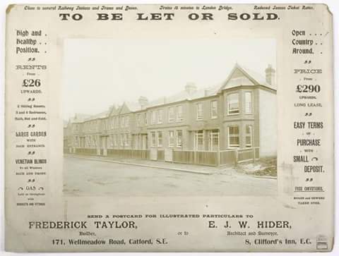
Running Past has ‘visited’ the Corbett Estate a couple of times before – firstly, looking at North Park Farm – whose sale was to allow the development of the estate, and early in the development a walk with one of Charles Booth’s researchers in 1899.  This post relates to a period a few years later in the development and was ‘triggered’ by an advert for the sale of newly built houses on the Corbett Estate that periodically appears on social media.

So where is the row of houses?  Well it certainly isn’t the 171 Wellmeadow Road of the advert (see two photos down) – they are larger semi-detached houses than those pictured above.  The shape of the roof at the right is unusual, and, from a couple of runs up or down almost every street on the estate (with a tiny bit of help from Streetview), it seems to appear on just a small number of roads – there are certainly a few houses at the southern end Ardfillan Road but the bay is wider there with two front-facing windows and the pointed roofs further down the advert are absent; at the northern end of the same road, the houses are again much wider, with two front-facing windows in the bay; a stretch of the terrace towards the northern end of Balloch Road is much closer, the property sizes seem right, but, again, the pointed roofs are missing.  However, the road in between, Birkhall Road, has the perfect match on its eastern side with the right mix on the neighbouring houses along with the rendering on the flank wall.  While there is no house to the right in the advertisement – this was probably just a later phase of the development.

The advert never seems to appear with a date; however, it would certainly be sometime after 1901 as 171 Wellmeadow was not occupied at that point according to the census, however, it probably wasn’t long after, as building work on the street started in 1904 (1) .

There had been considerable  price rises on the estate since we last ‘visited’ the Corbett Estate in 1899 with Charles Booth’s researcher, Ernest Aves, at that point the three bedroom houses were around £252, perhaps 5 or 6 years later, the advert prices them at £290.  Rents of £26 a year were only a £1 more than in 1899 though.  The houses advertised were more expensive than the similar houses being developed in Lee by the builders WJ Scudamore which were being sold for £265 around the same era.  The differences are minuscule compared with current prices – one of the houses in the photograph sold for just under £500,000 in 2015.

So which of the other streets on the estate did Frederick Taylor’s firm build?  The only certainty is the terrace in the photograph, however, it is very noticeable that the streets around Birkhall Road – the two mentioned above plus Ardoch Road, where the unusual gables are also present, have much less homogeneity than other streets on the Corbett Estate so maybe this ‘block’ was the area constructed by Frederick Taylor.

Frederick Taylor was certainly not the only builder to work on the Corbett Estate – as was noted in an earlier post, much of the work was sub-contracted by Corbett, whom Booth described as ‘speculator in chief‘; Running Past has covered one of the other sub-contractors, James Watt, who built a lot of homes elsewhere in Catford in his own right, along with running a chain of cinemas.  Another was John Lawrence, of whom little is known other than his name cropped up in a legal dispute between Cameron Corbett and the Borough Council relating to unpaid building control fees (2).

So who was Frederick Taylor?  He was certainly living at 171 Wellmeadow Road (above) when the census enumerators traipsed through the nearly completed Corbett estate in 1911 – the family had been living in Lambeth where he was listed as a builder a decade earlier.  He was then 49 and from Camberwell; he was married to Charlotte from Chelsea, with three children the youngest of whom was born in Lewisham in 1907.  There was an 11 year gap back to the middle child who had been born in Dulwich. Sadly Frederick was not to live much longer, he passed away in 1914; the family seems to have moved to Eltham Road in Lee just before his death.

The 1914 Kelly’s Directory lists a builder, Frederick Taylor, at 152 Muirkirk Road (below), this may have been the same man, as Kelly’s Directories always seemed a year or two behind reality, or it could of course have been his son, also Frederick, carrying on the business.  There was no mention though in the next available directory in 1917 though.

As for the architect, Ernest Hider, he had been born in Lee in 1871, and stayed in the area until his 20s – he was a Surveyors Clerk in 1891.  By the time the houses in Birkhall Road were being built he had moved away, the 1911 census had him listed in Clacton and seems to have been an active mason.  By the time the 1939 Register was drawn up he was in the Surrey commuter belt, where he died in 1960.

Notes

  1. Godfrey Smith (1997) ‘Hither Green: the Forgotten Hamlet : Including the Corbett Estate’ p42
  2. The Times (London, England), Monday, May 06, 1901; pg. 14; Issue 36447.

Census and 1939 Register data is via Find My Past

Kelly’s Post Office Directory data from University of Leicester 

If I have unintentionally breached your copyright on the ‘featured’ image (like several others) please do let me know and I will happily properly credit the image,

A Victorian Walk Around the Corbett Estate

A month or two ago it was noted in another post on Running Past, that there had ‘probably never been a single sale of land around Hither Green and Lee that has been more significant than the sale of North Park Farm by the Earl of St Germans in 1895 as it allowed for the development of was initially known as the St Germans estate, now generally known as the Corbett estate.’ This post picks up the story a few years after the sale after development was well under way, but far from being completed.

We return on 15 November 1899 in the company of one of Charles Booth’s investigators, Ernest Aves (there is a biography of Aves here)and PC Lloyds from Ladywell Police Station, who lived locally in Harvard Road.  The walk gives a fascinating insight into the early days of the estate.120px-charles_booth_by_george_frederic_watts  Charles Booth (picture Creative Commons), the centenary of whose death is on November 23, 2016, conducted an ‘Inquiry into Life and Labour in London’ between 1886 and 1903 – for much of the city he produced wonderfully detailed maps coloured on the basis of income and the social class of its inhabitants.  His assessment was based on walks carried out either himself or through a team of social investigators, often with clergymen or the police, listening, observing what he saw and talking to people he met on the road.  Sadly, no map seems to be available for most of the walk but below is an extract which includes the most southerly part of Hither Green that seems to have been mapped – available from London School of Economics as a Creative Commons.

image

booth

Albert Lloyds was about 35 and has been in the police for 11 years all of which has been in Lewisham, Booth feels that he is unlikely to get promotion due to his lack of education, he had five children in 1899.  By the 1901 census Albert Lloyds, from Newchurch in Kent, was still living at 35 Harvard Road, with his wife Ellen and 7 children in a two bedroom house.

Corbett was described as ‘speculator in chief’ but was subletting much of the work, the contractors included James Watt, whom Running Past has already covered.  The estate is described as being mainly for the ‘lower middle class’ and two styles predominated – ‘a small single fronted house letting at about £25 and a somewhat larger double-fronted house letting at £36 to £38.‘  The larger houses in Brownhill Road attracted a rent of £60.  These were presumably monthly rentals.  But there were lower, weekly, rents around ‘working class’ Sandhurst Road.

Aves seemed almost surprised that ‘many of the houses throughout the estate are said to be owned by their occupiers‘. Sale prices, on a leasehold basis a year earlier in 1898 had been £379 to £470 for the largest six bedroom homes; £298 – £353 for four bedroom homes and £215 to £252 for the 3/4 bedroom homes.  The smallest 3 bedroom homes on the estate were not offered for sales until 1903 (1).  The biggest of these are now fetching over £1 million, as was noted in a recent post in Clare’s Diary.

Duncrievie Road
His starting point was where we had left the estate a few years earlier in a post about the farm that came before the estate – North Park.  The original farm, occupied for years by William Fry, had gone, but houses occupied by the Sheppards were still there.  Eliot Lodge (below), at the corner of Hither Green Lane, was still occupied by Samuel Sheppard and the other, the former house of Edward Sheppard, was occupied by the Chief Agent for the estate, Robert Pettigrew who was from Edinburgh – it was referred to as North Park House in the 1901 census.  Both were given the second highest rating by Aves/Booth – red – ‘Middle class.  Well to do.’  Oddly Pettigrew wasn’t always in this trade, he’d been a storekeeper in 1881, but may have come across Corbett whilst the latter was developing in Ilford – he returned to Essex after he retired.

image
Springbank Road
While some of the shops had been built, but certainly not all and only two or three let – this was perhaps not surprising, while the road was laid out, the houses were yet to be built.  The bustling parade of a decade later (see below – source eBay September 2016) was yet to come.

springbank

The only houses were the other remnants of North Park farm, the ‘pink’ (Fairly comfortable.  Good ordinary earnings) former farm cottages at the corner of Hither Green Lane.
image

Wellmeadow and Broadfield Roads
The northern parts of the road, closer to the station, had already been built as had the ‘large Weslyan Chapel building’ (covered a while ago in Running Past) but south of Brownhill Road it was still under construction.

HG Church

Source – eBay February 2016

The pattern was the same with Broadfield Road (wrongly mentioned at Brookfield). Aves referred to the streets as a ‘pink barred’, this is a slight variant on some of his earlier definitions – in correspondence, this seems to mean ‘high class labour – fairly comfortable good ordinary earnings’

Brownhill Road
This was oddly described as ‘the swell road of the estate’ – many of the larger houses had already been built and were ‘red’ with a few of the pink barred blocks of houses constructed.

Ardgowan, Torridon, Arngask and Fordel Roads
Ardgowan Road, north of Brownhill Road, had been completed by the time Lloyds showed the estate to Aves, but to the south, construction was still ongoing; the opposite seemed to be the case with Torridon Road. Arngask and Fordel Roads were both completed, but Aves merely seemed to pass by noting the same pink barred colouring of the other two streets.

torridon-1910-l-wiki

Torridon Road from a decade or so later via Lewisham Archives on a Creative Commons

Glenfarg and Sandhurst Roads
These were described as ‘the two working class streets’  they were largely built, unlike much of the rest of the burgeoning estate, to rent on a weekly basis and these were the slightly lower graded pink (without barred element).

Aves with his interest in poverty lingered here longer, seemingly mainly on Sandhurst  Road –

‘most occupied by a decent class, but many on the down-grade.  Two families (per house) frequent, and even in passing many signs of deterioration observable.’

Many living in these streets were employed on the estate and would be expected to leave when the work was finished.  Given the estates position in then suburbia, Corbett presumably felt that to get the workers, he needed to build houses for them first – there seemed to be no philanthropy here, just business necessities.  Certainly, Smith noted that these houses were much later coming onto the market (2).

Maybe influenced by his companion, Aves noted that

The street (Sandhurst) is not getting a good name, and disorder and drunkenness are not uncommon, in spite of the absence of licensed houses in the intermediate neighbourhood.

Booth still felt the road to be mainly pink, but, apart from the shops of Sandhurst Market, that it would be turning ‘purple’ (‘Mixed. Some comfortable others poor.’)

It took another eleven years for the the building work to be completed with homes on Verdant Lane and Duncrievie Road being finished in 1910 (3).  The difference between 1894 and 1914 is enormous as the maps below show (both maps on a Creative Commons from the National Library of Scotland).

image
At some stage in the not too distant future we will pick up the story of the estate just before World War 2, to see whether the predictions of Aves and Booth proved to be correct.

Notes

  1. Godfrey Smith (1997) ‘Hither Green: the Forgotten Hamlet : Including the Corbett Estate’ p40
  2. ibid p40
  3. ibid p42

Census and related data comes from Find My Past.

The Lost Methodist Church of Hither Green Lane

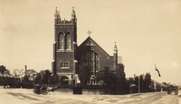
The Church had an impressive position on the angle of Wellmeadow Road and Hither Green Lane and was part of the St Germans Estate, now generally known as the Corbett Estate, it was one of seven places of worship built on the Estate – although there were no public houses or off-licences.

Source EBay February 2016

Source – EBay February 2016

The foundation stone was laid in July 1899 and completed the following year at a cost of £4,800, and accommodated 700 worshipers.  The building work was carried out by C. Castle & Son of Lower Clapton, little is known of them other than it was may well have been the son, Frederick William Castle, who was carrying out the work.  The firm went ‘bust’ in 1911 when Frederick was living in Alcester Crescent in Lower Clapton trading out of Milton Works Shacklewell Lane in Hackney.

The church has been described as being of

red brick with stone dressings in the 16th century Gothic style with heavily traceried windows and a tall pinnacled tower. The interior consisted of a nave, two aisles, a transept, chancel, organ chamber and galleries on three sides.

Its architect was Josiah Gunton was born in the tiny Fens village of Manea, about 4 miles north west of Ely in 1862. In the 1871 census he was 9 and living with an elder brother, William, and his father, also Josiah who was a farmer.  His mother died just before the census was carried out.

In the 1881 census, he was lodging with the Collard family in St Phillips Road in Hackney and was listed as an Architectural Assistant.  He isn’t recorded in either the 1891 or 1901 censuses but married Jessie Runchman from Hackney in 1886, it was probably his second marriage as both his children pre-dated the marriage and his staunch Wesleyan Methodist views would have no doubt ‘prevented’ having children outside wedlock.  They probably stayed around East London – he was captain of Walthamstow Cricket club in in the late 1880s.

By 1911 he and Jessie were  living at 23 Orchard Road in Bromley  and had  two children still at home who had been born in Hackney two decades before, and  along with 3 servants.

Josiah Gunton was articled to the firm Gordon & Lowther and was taken into partnership in 1885. After the death of Lowther in 1900, the practice continued as Gordon & Gunton. William Henry Gunton, Josiah’s son who had been born in 1881 joined as partner in 1916.  Josiah Gunton designed many Wesleyan chapels but the firm Gunton & Gunton tended to specialise in commercial buildings after World War I.

Gunton was a City of London Alderman, having initially been elected for Coleman ward in 1904.  He was a member of the London County Council for the Municipal Reform Party (allied to Conservatives) from 1928 until his sudden death on 5 March 1930 at Hotel Metropole, Monte Carlo, Monaco. There were suggestions that but for his death he might have been elected as Lord Mayor.

The church was destroyed during a raid on the night of 11 September 1940, which also caused a fire a few hundred metres up the road at the Park (later Hither Green) Hospital.

It is not clear why some local churches destroyed in WW2 were rebuilt, such as the Good Shepherd in Lee, but others such as Holy Trinity in Glenton Road and Christ Church in Lee Park weren’t – the latter two have both already been covered in Running Past.  Hither Green Methodist church was one of those that were never rebuilt.  The congregation seems to have largely moved to another Methodist church on the Corbett Estate – what was then known as the Benson Memorial Church on Torridon Road.

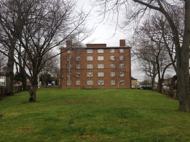
The site of the church was redeveloped for council housing after World War Two which is known as Littlebourne – while they are flats that, from the outside at least, have stood the test of time well, and been on the site much longer than the church, they are perhaps not quite so impressive looking.

image

The Benson Memorial Church suffered bomb damage in 1944, possibly as a result of a V1 attack on 4 August which hit Arngask Road, which was opposite the church,although it was initially reported as hitting Torridon Road.  The congregation had to move into the neighbouring church hall.  The Benson Memorial Church eventually became known as Hither Green Methodist Church and remained in the church until 1995 when it was sold for housing.  The hall was modified and refurbished as both a hall and church in 1996.

Note

All the census and related data came via Find My Past