Tag Archives: Hither Green Ditch

Beating the Bounds of Lee, Part 6 – Following the Quaggy

During the 2020 Coronavirus lockdown Running Past followed the long, thin boundary of Victorian Lee before it was subsumed into Lewisham in 1900, aided only by a 1893 Second Edition Ordnance Survey map. This has been in stages, from Lee Green to Winn Road, appropriately passing Corona Road en route; the second part took us through Grove Park, crossing the never built Ringway; we then passed through Marvels and Elmstead Woods and a Borough of Deptford Cemetery; the fourth part took us through Chinbrook Meadows appropriately following Border Ditch; and the last part followed the hidden stream Hither Green Ditch more or less parallel to Verdant Lane and Manor Lane.

We left the boundary at the confluence of Hither Green Ditch with the Quaggy to which we will return, following the red dots on the map.

The confluence has actually moved – in 1893 it was more or less where 49 Longhurst Road is now located; it is now around 40 metres away on a sharp corner between between Manor Park and Leahurst Road (pictured below).

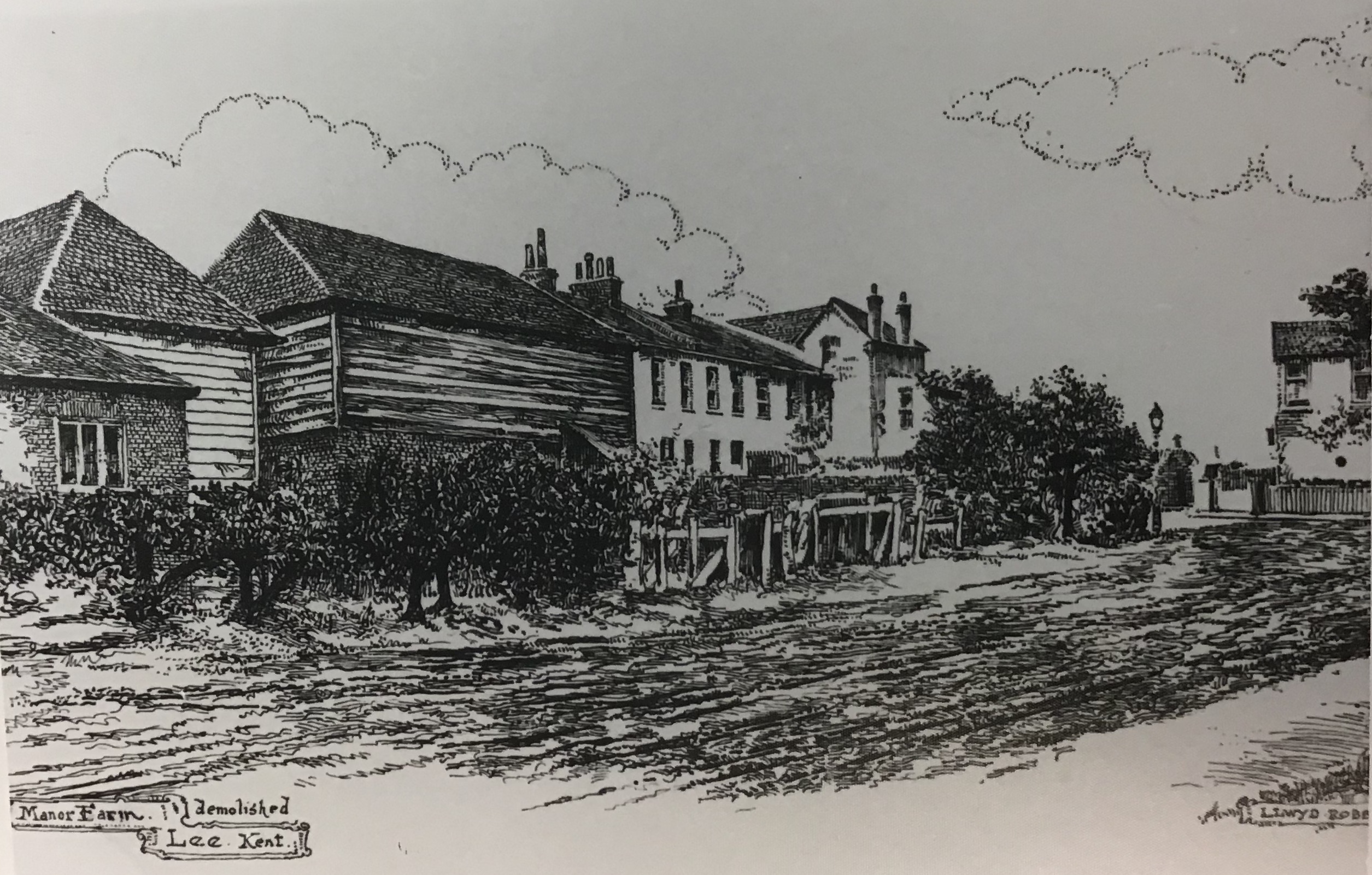
In 1893 this was still, just, the land of Lee Manor Farm, although this would change dramatically over the next decade. As was the case when we followed the boundary along Hither Green Ditch, the Quaggy not only was the Lee – Lewisham boundary it was one between two farms. On the west was North Park Farm (the top of the map below) and on the east Lee Manor Farm – the sale of the former to Cameron Corbett who created what is known as the Corbett Estate and the latter by the Northbrooks in a more piecemeal fashion was to shape the urban landscape.

The boundary was within the flood plain, with the Quaggy meandering along the boundary of the farm, the Lee – Lewisham boundary of 1893. While this was acceptable in farmland it wasn’t in relation to the smaller suburban housing about to be developed the east of the railway. Memories of the devastating floods of 1878 will still have been prominent – the theory about dealing with such floods, which prevailed until the end of the following century, was to deepen and straighten the river, moving the water on as quickly as possible – this is clear from the photograph below. This approach also made development easier as had been seen with the development of Lampmead Road following the sale of Lee House in the 1880s.

Like the previous sections, the boundary is being followed on foot, the footwear of choice has changed though because while the rest of the route has been run, this section, apart from a 300 metre covered section in central Lewisham, is by walking along the river bed so waders became the footwear of choice.

The river and boundary continue to diverge for a little, the 1893 flow of the Quaggy and consequently the boundary meandered along what is now broadly Longhurst Road. It was never any more than 50 metres away from the river’s current, very straight, deep, engineered course. The convergence of the 19th boundary and the Quaggy more or less where the 21st century bridge from the the entrance from Longhurst Road into Manor Park is now situated – just above the start line for the annual (in non-COVID-19 years) Quaggy Duck Race.

While the Quaggy and Lee – Lewisham boundary are now coterminous and the meanders are broadly similar in 2020 to 1893, much changed in the intervening period. The Quaggy was straightened and channelised through what until the 1960s was the last bit of farming in Lee – a piggery. The open space, Manor Park, was created in the mid-1960s with meanders restored to something very close to those that existed in 1893 in 2007.

At the exit of the Park, there is a bridge, it is a long-standing crossing of the Quaggy, part of an ancient path known as Hocum Pocum Lane which ran from St Mary’s Church in Lewisham to Lee High Road. Despite the work done further upstream to deepen and straighten the course it flooded badly here in 1968.

Beyond Manor Park, the river and 1893 boundary squeezes between the Victorian housing of Weardale Road and Eastdown Park. The land for the latter land had already been developed by 1893, Eastdown Park on land that had been cultivated by the market gardens of Lewisham Nursery, run by Messrs Willmott and Chaundy, until 1860.

Beyond the river’s first meander is the garden of 45 Eastdown Park, possibly very briefly home to the Ginger Baker, his father was there just before the Cream drummer was born in 1939.  A hundred metres or so further on another there is another building with a musical history – the Rose of Lee, now Dirty South, which saw the first public performance by Kate Bush.

We have already mentioned serious flooding that occurred in the spring of 1878 in relation to straightening the Quaggy upstream.  However, while the meanders and boundary of Lewisham and Lee hadn’t changed since then, the depth of the watercourse had.  It is at least half a metre lower than in the prictue showing the partial destruction of the bridge in Eastdown Park.  So whilst it is a pleasant wander down the river there is little to see beyond boundary walls and banks for much of this stretch.

In 1893 on the opposite side of the Eastdown Park bridge was a Baptist Chapel, this was largely destroyed during World War 2 and the site is a vacant garage, last home to Penfold’s.

Both sides of the river and boundary into Lewisham were lined with housing in 1893; on the Lee (High Road) side a few remain, 152 was once home to William Sidery (pictured top) part of a multi generational Lee building firm.  Grove Cottage next to the Ambulance Station dates back to 1835 and 96 is the last remaining section of Lee Place (not to be confused with the eponymous mansion off Old Road) which was built in 1813 (lower picture) (1).

The remaining houses were largely lost to Fry’s garage and showrooms, which themsleves were replaced by a large Lidl and topped by an even larger block of flats this century.

On the opposite side of the river in Lewisham in 1893 was the well established College Park estate, briefly home to the poet James Elroy Flecker.

Behind the housing the river retains a pleasant almost rural feeling idlyll – it has probably changed very little in the 127 years since the Ordnance survey map being followed was surveyed.  

Beyond Clarendon Rise bridge, on the Lee side, was the Sultan in 1893 (pictured from early in the 20th century below), replaced in the last decade by Nandos; on the Lewisham side of the bridge is now the beautiful Hindu temple although that was a yard in 1893. Penfold’s moved into the site adjacent to both, known as Clarendon Yard around 1904.

The river disappears under what was referred to as Lee Bridge in 1893 for around 300 metres.  Alas, dear reader, this part was done at street level. 

The raised area above the river was an established shopping parade in 1896 with a tea dealer (83), a pair of boot makers (75 & 81), a wool shop (79), a confectioners with an architect and auctioneers above (77), Singer’s sewing machines (73), a stationers (71), a series of household goods shopsunder George Stroud’s ownership (65-69), a chemist (63), a florist (61) and the mainstay of that part of Lewisham high Street for generations – Chiesman’s Department Store (pictured a few years into the 20th century). 

Much has changed now, rather than Chiesmans dominating the street scene it is a massive and not particularly attractive police station. 

On the side of the police station is memorial that celebrates the contribution of Asquith Gibbes to Lewisham and, in the context of of the Black Lives Matter protests of earlier in lockdown, seems an important place to pause. Such memorials to members of London’s Black community remain a rarity, although just inside the Lee border is the Desmond Tutu Peace Garden, Tutu was a curate in Grove Park.

Asquith Gibbes was born in Grenada, and arrived in Britain in the late 1950s, working in Lewisham for 40 years fighting racial inequalities in education, policing and housing. There is a fuller biography of him as part of the brief for the memorial – two examples of his work have national significance. He chaired Millwall Anti-Racist Trust and instigated the ‘Kick it Out’ programme at Millwall Football Club in 1993, a campaign that was adopted nationally. Asquith was also part of very significant work with the Association of Chief Police Officers and the Home Office on reforming ‘stop and search’ rules.

Returning to the Lee – Lewisham boundary of 1893, the Quaggy re-emerges just beyond the shops of 1893 and the police station. The boundary though takes a sharp turn to the east (right) by St Stephen’s church, at what is/was the confluence of the Quaggy and Upper Kid Brook, following the latter towards Blackheath. We’ll cover that part of the boundary at our next visit.

Picture Credits

  • The picture of Chiesmans shop in Lewisham is via e Bay in June 2016
  • The photographs of 1968 floods, the destroyed bridge in Eastdown Park and the map of Lee Manor Farm are from the collection of Lewisham Archives and remain their copyright, but are used with their permission
  • The Ordnance Survey map of 1893 is via the National Library of Scotland on a non-commercial licence
  • The photograph of the Sultan is used with the permission of Robert Crawford, the great grandson of the Craddocks, licensees there in the 1920s, it remains his family’s copyright.

Note

1 Lewisham Leisure (1990) ‘From the Tiger to the Clocktower’

This, and the rest of the series of posts on the Lee boundary, would probably not have happened without Mike Horne, he was the go-to person on London’s boundary markers; he had catalogued almost all of them in a series of documents. He was always helpful, enthusiastic and patient. He died of a heart attack in March but would have loved my ‘find’ of a London County Council marker in some undergrowth on Blackheath during 2020’s lockdown, and would have patiently explained the details of several others he knew to me. A sad loss, there is a lovely series of tributes to him via this link.

Beating the Bounds of Lee, Part 5 – Verdant Lane and Manor Lane

During the 2020 Coronavirus lockdown, Running Past has been following the boundary of Victorian Lee before it was subsumed into Lewisham at the end of the Victorian era, aided only by a Second Edition Ordnance Survey map. We have so far wandered, in stages, initially from Lee Green to Winn Road, appropriately passing Corona Road en route; the second stage took us through Grove Park, crossing the never built Ringway;  then through Marvels and Elmstead Woods and a Borough of Deptford Cemetery; and in the previous instalment through Chinbrook Meadows appropriately following Border Ditch. We pick up the 1893 Lee – Lewisham boundary on what is now Downham Way – the most southerly of the red dots on the map below.

The Downham estate was built by the London County Council (LCC) in the late 1920s and early 1930s on compulsorily purchased farm land. On this side of the estate included what was probably the last outpost of the land owned by the Baring family, Shroffold Farm, pictured later in the post.  We will probably return to the farm at some stage in the future. However, the farm was part of the Manor of Lee bought by Sir Francis Baring, later Baron Northbrook, the purchase of which was at least partially funded by both financing of slave owning operations as well as some direct ownership on enslaved people. While the Barings dispensed largesse to the locals in their latter years, their ability to do this was based, in part at least, on the enslavement of African men, women and children in Montego Bay in Jamaica at the end of the 18th century.

We’d split our circuit of Lee at the top of what was described in a 1790 map as ‘Mount Misery’, better known these days as Downham Way (the most southerly dot on the map). There was a lot of ‘misery’ in the area in that era. South Park farm, which was to become North Park – a little further down the hill in our broad direction of travel was a farm that for a while was known as Longmisery.

The reason for the split in the post at Mount Misery was that the boundary in 1893 had changed soon after the brow of the ‘Mount’ from field edge to stream at the boundary.

Before leaving this point, it is worth remembering that at the time the Ordnance Survey cartographers surveyed the area they would have had an undisturbed view almost to the north of the parish and St Margaret’s Church. Certainly this was what the local Victorian historian, FH Hart, noted in the early 1880s when following the boundary from this point.

The stream is Hither Green Ditch; a stream that Running Past followed a while ago which has several sources. The nomenclature ‘Ditch’ is used quite a lot within the Quaggy catchment, it shouldn’t be seen as belittling or derogatory it is just the way smaller streams are described – the 1893 boundary of also followed, Grove Park Ditch and Border Ditch, with Milk Street and Pett’s Wood Ditches further upstream.

This branch of Hither Green Ditch seems to have emerged somewhere around Ivorydown, south and above Downham Way. It merges with the 1893 Lee – Lewisham boundary just north of the street named after the farm, Shroffold. The merged boundary and stream followed the middle of Bedivere Road.

The section that the Lee-Lewisham boundary initially followed, is one of the sections of Hither Green Ditch that is barely perceptible on the ground, although the contours are clear on early 1:25,000 Ordnance Survey maps, if not current ones. Whether this part of the stream was actually flowing in 1893 is, at best, debatable, water tables had declined after the end of the Little Ice Age, the last really cold winter was in 1814 – with extensive flooding around the parish of Lee when there was a thaw.

The boundary and stream followed the edge of a small piece of woodland in 1893 which is now an area bordered by Pendragon, Ballamore and Reigate Roads. There is an attractive U shaped portion of the latter, where council surveyors struggled with dampness from the hidden Ditch.

The post war 1:25,000 Ordnance Survey map, notes a flow at around the point of Railway Children Walk, an homage (or a homage) to E Nesbit who lived on the other side of the railway – on of at least a trio of locations within the Parish she resided in. A small detour is worth making for a view of another Lewisham Natureman stag standing proudly above the railway.

Detour made, the boundary follows Hither Green Ditch which was marked as flowing in the 1960s 1:25,000 Ordnance Survey map, so was presumably also flowing in 1893. To the west of the Ditch, and boundary, was Shroffold Farm, the farmhouse (pictured below from the 1920s) was where the mosque is now located – diagonally opposite to where the Northover/Governor General was to be built 40 years later at the junction of Verdant Lane, Northover and and Whitefoot Lane. To the east was almost certainly land belonging to Burnt Ash Farm – both sides of the boundary owned by the Northbrooks.

While fields in 1893, this area is now part of Hither Green Cemetery. It originally opened as Lee Cemetery in 1873 but with a much smaller size at the northern end of the current one. Like the Borough of Deptford cemetery we passed through in Grove Park, it was outside the jurisdiction it served, all on the Lewisham side of Hither Green Ditch. There are two impressive chapels, the Dissenters one (for Methodists and the the Baptists of Lee High Road and what is now Baring Road), was built by William Webster of Blackheath and was damaged during the last war and is slowly decaying.

The southerly end of what is now the cemetery had changed from farm land to allotments in the early part of the 20th century. The exact timing of the expansion of the cemetery into the allotments isn’t clear, it was probably just before or just after the start of World War 2, it was showing as allotments in the 1938 surveyed Ordnance Survey map. But by the time the children who died in the awful attack on Sandhurst Road School in early 1943, were buried the area had expanded. There is a large memorial to those who perished, something covered in a blog post that marked the 75th anniversary of the bombing in 2018. The crematorium in the south east corner was opened in the 1950s.

The 1893 boundary is relatively easy to follow on the ground through the cemetery as Hither Green Ditch has left a small valley close to the Lombardy poplars that border the railway.

Just outside the cemetery in 1893 was a small hospital, Oak Cottage Hospital; it had been built in 1871 by the local Board of Works for dealing with infectious diseases like smallpox and typhoid (1).  It was overtaken by events in that the Metropolitan Board of Works (which covered all of London) decided to open a series of fever hospitals as a response to a major Scarlet Fever epidemic in 1892/93, the health system was unprepared and there was a severe shortage of beds.  One of these was the Park Fever Hospital, later referred to as Hither Green Hospital; Oak Cottage Hospital was briefly considered as a possible alternative location (2).   Oak Cottage Hospital closed soon after Park Fever opened in 1896 (3).  It eventually became housing in the 1960s or 1970s.

Beyond Oak Cottage Hospital in 1893, were again fields, probably part of Shroffold Farm. On the opposite side of Verdant Lane (then Hither Green Lane) was North Park Farm, about to be ploughed under by Cameron Corbett. The Lee Lewisham boundary continued to use Hither Green Ditch which was to remain visible until the development of the Verdant Lane estate in the 1930s. This section is pictured below, probably soon after the Corbett Estate was completed around 1910.

In addition to the Ditch, there were a pair of long gone boundary markers, one was just to the north of the junction of Verdant Lane and Sandhurst Road, perhaps at the point one of the confluence of two of the branches of the Ditch; the other where it crosses St Mildreds Road – again a possible branch of the Ditch that would have been obliterated by the railway.

St Mildreds Road hadn’t existed when the Ordnance Survey cartographers had first visited in the 1860s. While the church of St Mildreds had been built in 1872, even in 1893 only homes at the Burnt Ash Hill end had been build, including another of the homes in the area of E Nesbit in Birch Grove.

The boundary went under the railway close to what was a trio of farm workers cottages for North Park Farm, which are still there at the junction of Springbank Road and Hither Green Lane.

The boundary continued to follow Hither Green Ditch – it wasn’t just a Parish boundary at this point, but a farm boundary too – on the Lewisham side, Hither Green’s North Park Farm, which was mainly on the other side of the railway and was sold at around the time that the land was surveyed and would form the Corbett Estate. On the Lee side was Lee Manor Farm, which is pictured on a 1846 map below (right to left is south to north, rather than west to east) and Hither Green Ditch which had several small bridges is at the top.  There were several boundary stones and markers along what was broadly Milborough Crescent and Manor Lane.  There was then a sharp turn to the east along what is now Longhurst Road.

The confluence of Hither Green Ditch with the Quaggy was in a slightly different place in 1893, then it was more or less where 49 Longhurst Road is now located; it is now around 40 metres away on a sharp corner between between Manor Park and Longhurst Road, as pictured below.

We’ll leave the boundary of Lee and Lewisham here for now following what is now the Quaggy into Lewisham in the next instalment.

This series of posts would probably not have happened without Mike Horne, he was the go to person on London’s boundary markers, he had catalogued almost all of them in a series of documents. He was always helpful, enthusiastic and patient.  He died of a heart attack in March but would have loved my ‘find’ of a London County Council marker in some undergrowth on Blackheath, and would have patiently explained the details of several others he knew to me.  A sad loss, there is a lovely series of tributes to him.

Notes

  1. Godfrey Smith (1997) Hither Green, The Forgotten Hamlet p54
  2. Woolwich Gazette 02 June 1893
  3. Smith op cit p54

Picture Credits


Lee Manor Farm -‘Old’ Lee’s Last Farm

As regular readers will no doubt recall Running Past has covered many of the former farms of Lee – Lee Green Farm, College Farm, Melrose Farm, Horn Park Park and Burnt Ash Farm.

The land of Burnt Ash Farm had originally been farmed from a large house which was on the site of what is now Lee Manor House.  It was probably not an ideal location for the farm as its land was virtually all to the south – stretching away towards Grove Park.  The move to the junction of what is now St Mildred’s and Baring Roads happened in the mid-1720s (1).  The remains of the original Farm on Old Road were found underneath the library when some building work was undertaken in the early 1980s.

The shift in location to Burnt Ash was by Thomas Butler who came from Dagenham in, what was then, rural Essex (2).  Perhaps as early as 1739, and certainly after Butler’s death in 1751 (3), Burnt Ash Farm was split between two of his sons, Matthew who remained at Burnt Ash and farmed the land south of St Mildred’s Road; and James who was to farm what was to be called Lee Manor Farm.  The land was most of the area bordered by Burnt Ash Road, what is now St Mildred’s Road, the stream Hither Green Ditch until it joins the Quaggy, the river itself and Lee High Road.The initial site of the farmhouse was to the west of Pentland House (at one stage called Foclallt House) on what is now Manor Lane Terrace and included the site of Lochaber Hall (on the 1860s map above it is referred to as Manor Cottage).  It was a large three-storey house with extensive outbuildings (4).  The land was not owned by the Butlers and, as was covered in a post on the Manor House, was bought by William Coleman who sought to recreate the old Manor of Lee for his nephew Thomas Lucas – funded by the proceeds of slavery.  Lucas inherited the farms on his uncle’s death in 1771.

On James Butler’s death in 1762 it seems likely that the Farm was again managed by his brother, Matthew, from Burnt Ash (5). After Matthew’s death in 1784 the tenancy of the two farms were taken on by Baron Dacre of Dacre House, whose estates were relatively small.  (6) We will return to Dacre House at some point in the future.

Following the deaths of Lord Dacre in 1806 and Lady Dacre in 1808, there were some changes to Lee Manor Farm.  Part of the land bounding Lee High Road was sold to the new owner of The Firs, Christopher Godmond, who had bought the House after the death of David Papillon. (7)

The farm house had be let separately since the 1780s; so when Lee Manor Farm was again let and managed in its own right in 1808, a new farmhouse was needed for a new tenant.  The new farmhouse was built on what is now Manor Lane Terrace, between the current Northbrook and Kellerton Roads (it is shown on the map above).  The bend in Manor Lane Terrace is explained by the location of the farm.   The artists impression of the farm is by Lloyd Roberts (see credits below).

The new tenant was the butler of the new Lord of the Manor, Sir Francis Baring – Thomas Postans (8) – Postans was to stay there until 1816, when he moved on to manage the kitchen gardens of the Manor House to supply the officers mess at St James Palace.  Mr R E Brown was the tenant of the farm for this period but Postans returned to the Farm in the mid 1830s.

There is a fascinating map of the farm from towards the end of Thomas Postans tenure drawn with an east – west axis; Lee Green is in the bottom right hand corner with Burnt Ash Road providing the bottom boundary (the other side of Burnt Ash Road was Crown Estate land) and Lee High Road to the right of the map.  There is considerable overlap between the 1843 field pattern and the street pattern that emerged in the decades afterwards.

In 1845 a lease was granted to Mark Cordwell who hailed from Buckinghamshire; oddly he was listed as a seaman in the 1861 census with with his 20 year old son, Charles, born in Greenwich, noted as as the farmer.  Mark died in 1864.

By 1881, Charles had married Mary (née Peasnell) who was from Buckinghamshire, like his father, and had eight children and a servant living on the farm; the farm was listed at 150 acres in the census. They may have had a bailiff or manager running the farm for them for a while in the 1870s as three children were born in Shoreham in Kent.  In the 1871 census they were listed at Prestons Farm House  in Shoreham.

They were back in Lee in 1891; but by the 1901 Census, Charles was listed at 35 Medusa Road in Catford as a ‘retired farmer’ with his son and daughter in law.  He may have emigrated to the USA as the last record for him is sailing to New York on the Philadelphia in 1906.

While he may have moved to America, his name lives on in the 1970s council housing that was developed to replace the southern side of Northbrook Road and land behind Kellerton Road – Cordwell Road.

The end of the farm coincided with the gradual sale of of the Northbrook estate from the 1860s onwards.  One of the main builders from the mid 1890s were the family firm W J Scudamore.  Their developments included what they referred to as the Manor Park Estate (roads such as Kellerton Road, parts of Manor Lane Terrace, Redruth Road (now Manor Lane) and parts of Manor Park.  It seems that the old Manor Farm came as part of the lot; most developers would have probably demolished the buildings and built over it.  However, the Scudamores decided to retain the building as a family home – which it remained as until the 1960s – there is a little more on this in the post on W J Scudamore.

The last of the Scudamores to live in Manor Lane Terrace was Elizabeth (née Drane) who died in 1961 aged 90.  After her death, the house and the land around it were acquired for council housing – although all the homes appear to have been sold under Right to Buy.  The name Wolfram Close is presumably a reference to the last tenant of the Manor House – the slightly differently spelled Henry Wolffram.  

Notes

  1. Josephine Birchenough (1981) Some Farms and Fields in Lee p4
  2. ibid p5
  3. ibid p7
  4. ibid p7
  5. ibid p8
  6. ibid p9
  7. ibid p9
  8. ibid p10

Picture Credits


The 1930s Verdant Lane Estate – ‘Delightful Houses’ for Skilled Workers

The Verdant Lane estate was developed in the early 1930s with most homes sold by the middle of the decade – it consists of homes on the eastern side of Verdant Lane itself plus the streets of South Park Crescent (named after the former farm on the opposite side of Verdant Lane that became part of North Park Farm); Further Green Lane plus the smaller streets of Pasture Road and Sedgeway. The newly built houses, as we shall see later, were to become the homes of skilled working classes along with a few supervisory staff and managers.

The opposite side of Verdant Lane had been developed by Cameron Corbett as part of the development of North Park Farm, the west side of Verdant Lane had been one of the last streets to be developed in 1910 (1). The land now occupied by the Verdant Lane estate was presumably not farmed by the Sheppards at North Park and was probably part of Shroffold Farm which was located where the mosque is now situated at the junction of Verdant and Whitefoot Lanes with Northover.  Latterly, like much of the newer part of the cemetery, it was allotments as the map below shows.

The allotments are clear in the photograph below, taken from 140 Verdant Lane around 1920 (see credit below) – the bend in the road is the junction of Verdant Lane and Sandhurst Road.  The photograph also shows trees bordering one of the Quaggy’s tributaries, Hither Green Ditch; the stream seems to have been culverted around the bulge in the fencing.  The course of the Ditch is obvious in the small valley on Pasture Road, the remnants of the stream is probably now culverted either under the front gardens of Verdant Lane or under the access tracks to garages behind.

Adjacent to the estate was Oak Cottage Nursery, which dated from at least the 1860s, perhaps earlier.  The nursery lasted until after World War 2 (the map below is from the early 1950s), presumably until Oak Cottage Close was built in the 1960s or 70s. A small part of the nursery remains as a lovely community garden

The builders of the estate were J Gerrard and Sons from Swinton in Greater Manchester; they had been founded in 1864 by Jonathan Gerrard.  Gerrard had died in 1906, but the firm was still within the family, although by this stage focused in the main on large scale public building contracts including hospitals and public housing for Manchester City Council.  Private sector housing, particularly in southern England, seems to have been something of a rarity for them at this stage in their evolution.

By the 1950s they seem to have been specialising in building power stations, such as Fleetwood in 1956. It appears that the construction arm was sold to Fairclough in 1971, who in turn were taken over by AMEC in 1982 and then by Wood Group in 2017.  There is still a haulage firm operating and still run by the Gerrard family.

Who designed the houses isn’t clear – it may have been an in house team and they seem to have done their own sales, presumably from a show house on the estate.

E17CAAB6-1B21-4E73-A176-CD0F7538E59D

The completion locally would have been on the Woodstock Estate,now mainly Woodyates Road, which was advertised in the same edition of Lewisham’s Official Guide (probably 1931).  While Woodstock was priced at £25 cheaper, with seemingly a similar specification, Gerrard’s, by asking for a higher deposit, managed to get the weekly cost to be slightly cheaper.

So who were the early occupants of the estate? The 1939 Register was effectively a mini-census carried out just before the start of World War 2 for the purposes of rationing.   It isn’t completely comprehensive, as anyone likely to still be alive now is redacted and those in the armed forces were not included. As part of the research for this post, the records of the 36 houses on eastern side of Further Green Road (35 – 105 odds) have been reviewed.  While other parts of the estate might have been slightly different, it is probably a big enough sample to get a reasonable picture of who lived there.

The men of the estate were employed in a wide mixture of trades, but there were a mixture of skilled manual workers and a range of office and managerial jobs

  • The skilled manual workers included a metal machinist, a couple of telephone engineers, two train drivers and a plasterer; and
  • The office and managerial roles included several warehousemen, a Director of a Shipping Agent, a Civil Servant, a theatre clerk and an office manager.

The difference between Further Green Road and a similar study in 1939 of Ardmere Road in Hither Green is stark – a large majority in Ardmere Road were semi and unskilled manual workers – the only Further Green Road resident that would fall into this category was the Brewer’s Drayman at 89. This was one of the very few entries with the suffix ‘Heavy Work’ added after the trade.  This would have entitled those described to extra rations.  Of the 50 paid jobs, only four had ‘Heavy’ appended to them – one of which was probably an error as it was given to a shorthand typist….

As was the case in Ardmere Road, working women, other than a few grown up children, were a rarity – most were listed as carrying out ‘Unpaid Domestic Duties.’

One of the surprising features of the estate was the lack of children – these in the main are three bedroom houses but there were only 11 children in the 36 homes (assuming all the redacted entries were children). This was almost certainly due to evacuation of children which had started at the beginning of September 1939 – including in Lewisham.  Most had returned by 1943 as the estate had  one of the bigger concentrations of the child victims of the Sandhurst Road School bombing.

Notes

  1. Godfrey Smith (1997) ‘Hither Green: the Forgotten Hamlet : Including the Corbett Estate’ p40
  2. Manchester Courier and Lancashire General Advertiser 29 December 1906

1939 Register data is via Find My Past

Image Credits

The pre-development photo is copyright of the always helpful Lewisham Archives and is used with their permission.

The Ordnance Survey maps of Oak Cottage and the estate before development are from the National Library of Scotland and are on a Creative Commons – the

The advert and floor plans were copied from somewhere on social media in mid-2017, I thought that it was from the excellent cornucopia of all things London local government – LCC Municipal – mainly to be found on Twitter, but I was mistaken – so if you posted it do tell me so that I can properly credit you!

Finally, thank you to David Underdown for reminding me of the reasons for the lack of children on the estate in late September 1939 – most had been evacuated.


A Walk through Hither Green’s History

Hither Green has a rich and interesting history; this post was written to ‘accompany’ a walk organised as part of the 2018 Hither Green Festival, it can be used to independently to walk the route (its a circuit of around 1.8 miles) or as virtual tour of the area.  The ‘walk’ is divided into sections which relate to the planned stopping points – each of which is full of links to other posts in the blog which will have more detailed information.

Starting Point – Before the Railway

Hither Green station is the perfect place to start the walk as the railway ‘made’ the area.  At the time of the railway arrived in Hither Green in the 1860s, it didn’t stop – it was to be a junction until the mid 1890s.  When the South Eastern Railway navvies constructed the embankment and cutting through the area, Hither Green was largely rural, surrounded by farms as the map below shows – the farms including several covered by Running Past – North Park, Burnt Ash and Lee Green.

Hither Green Lane was there with several large houses but the main population centres were outside the area – the elongated Lewisham stretching all the way along what is now the High Street and Rushey Green, the three parts of Lee – Lee Green, the area around the church and Old Road, the latter with the Manor House and the farm and servants housing of Lee New Town.

While Hither Green remained a junction until the 1890s, the edges that were closer to other stations started to be developed – for example Courthill Road started to be developed from 1867, Ennersdale Road during the 1870s.  Then roads like Brightside, Mallet and Elthruda began to be developed in the late 1870s and early 1880s.  Everything changed with the opening of Hither Green Station on 1 June 1895 – the area lost its rural feel, most of the remaining large houses were sold and the Victorian and Edwardian houses and ‘villas’ built.

The Prime Meridian is crossed and marked in the pedestrian tunnel at Hither Green station, most of the walk will be in the western hemisphere..

Springbank Road & Nightingale Grove

A V-1 attack on devastated the area on the western side of the station on 29 July 1944 killing five  and destroying a significant number of homes, as the photograph (below) from the now closed ramp up to Platform 1 shows. It was one of 115 V-1 rocket attacks on Lewisham that summer – the most devastating had been the previous day when 51 had died in Lewisham High Street. Soon after the war nine prefab bungalows were put on the site; with the council bungalows probably appearing in the early 1960s.  The Beaver Housing Society homes on the corner of Nightingale Grove and Ardmere Road also replaced some of the homes destroyed – there are glazed tiles naming the landlord which is now part of L & Q Group.

© IWM Imperial War Museum on a Non Commercial Licence

Ardmere Road (covered in a 2 part post) was built in the 1870s but was considered one of the poorest in the neighbourhood by Charles Booth’s researcher Ernest Aves in 1899 – he described it as one of the ‘fuller streets, shoddy building, two families the rule.’ It was marked blue – one up from the lowest class.

The area was looked unfinished to Aves and there was even a costermonger living in a tiny tin shack with their donkey on the unfinished Brightside Road in 1899, along with a temporary tin tabernacle. This immediate area was very poor and in ‘chronic want’ compared with the comfortable middle class housing of much of the rest of the area.

Hither Green Community Garden

The Community Garden dates from 2010 – cleared and maintained by volunteers from Hither Green Community Association.

North Park Farm

The Community Garden would have been part of the farmyard for North Park Farm.  It was latterly farmed by the Sheppards, although the land was owned by the Earls of St Germans until the sale to Cameron Corbett in 1895 – there are already posts on both the farm itself and in the early days of the development.

There were two Sheppard brothers both of whom had houses – one of the farm houses remains at the junction of Hither Green Lane and  Duncrievie Roads (see above) – along with their long term farm manager William Fry, who lived in the original farm building around the Community Garden..

The shops (see below) were developed by Corbett early in the development – there was no pub as Corbett was a strict teetotaller. There was a beer house (licenced to sell beer but not wines or spirits) nearer the station in area demolished by the V-1.

There was a small stream which I have called North Park Ditch which ran through the farm – it is visible in the Hither Green Nature Reserve and was a tributary of Hither Green Ditch, which joins the Quaggy between Manor Lane and Longhurst Road.

The Old Station

The original entrance to the station was where Saravia Court , a block of housing association flats built around 2013, is now situated – it is named after the original name for Springbank Road.  The station buildings lasted until around 1974, when the booking hall was moved to its current location at platform 4½.  The site was used by timber merchants for many years.

The only remnants of the former station are the stationmaster’s house, 69 Springbank Road and the gate pillars to the former station entrance

Park Fever Hospital

This was the site of two of Hither Green’s larger houses – Hither Green Lodge and Wilderness House, these were sold to a private developer in the early 1890s and then onto the Metropolitan Board of Works who built the hospital after much local opposition.

Despite the 1896 signs, the hospital opened in 1897, it went through variety of guises including fever, paediatrics, geriatrics in its century of use.  The site was redeveloped for housing after the hospital closed in 1997.  There is a specific post on the the hospital and the housing before and after it in Running Past in early 2018.

Opposite the hospital in Hither Green Lane was the childhood home of Miss Read – she was a popular writer of rural fiction in the mid 20th century, who covered her time there in the first volume of her memoirs.

The Green of Hither Green, the area’s small bit of common land was  at the junction of Hither Green and George Lanes and was enclosed around 1810,

Roughly the same location was the ‘home’ to Rumburgh (other spellings are available) a settlement that seems to have died out as a result of the Black Death in the mid 14th century – this was covered a while ago in the blog.

Park Cinema opened in 1913 with a capacity of 500, it is one of several lost cinemas in the area.  It closed its doors in 1959 and was vacant for  many years  – it has gone through several recent uses including a chandler – Sailsports, a soft play venue Kids’ Korner and latterly another alliteration, Carpet Corner.

Its days seem numbered as a building as after several unsuccessful attempts to demolish and turn into flats – planning permission was granted in September 2017 after an appeal against a refusal by Lewisham Council.

Beacon Road/Hither Green Lane

The Café of Good Hope  is a recent addition to the Hither Green Lane, part of the Jimmy Mizen Foundation –  Jimmy was murdered on Burnt Ash Road on 10 May 2008.  The charity works with schools all over the United Kingdom, where Margaret and Barry Mizen share Jimmy’s story and help young people make their local communities safer, so they can feel safe when walking home.

The Fox and Sons ‘ghost sign’ is next door to the Café.  Ghost signs are painted advertising signs, they are not meant to be permanent – although were to last much longer than their modern day counterparts.  The urban landscape used to be full of them but most have been lost – either to modern advertising, being painted over or the buildings themselves being demolished lost.  There are still quite a few locally – the best local ‘collection’ is around Sandhurst Market at the other end of Corbett estate.  They can be

This was very briefly an off licence, there is a photo of it but it didn’t seem to last long enough to make local directories. There is much more on the brewery behind the ghost sign in a post here.

The Pillar Box on the corner of Beacon Road may look ordinary but it was attacked by suffragettes in 1913 – it was one of many similar attacks by Lewisham’s militant WSPU branch. 


St. Swithun’s Church

The church building dates from 1904, although the now church hall was used as a church from 1884.  Both were designed by Ernest Newton who also designed the Baring Hall, the original Church of The Good Shepherd and Lochaber Hall.  Gladys Cooper, the actress was baptised here.

Perhaps the biggest surprise with St Swithun’s (pictured above) – is that it is still here.  So many of the local churches were lost in World War Two – the Methodist Church at the junction of Hither Green Lane and Wellmeadow Road, the original church of The Good Shepherd, Christ Church on Lee Park and Holy Trinity on Glenton Road.

Merbury Close

Merbury Close was developed as a sheltered scheme for the elderly in 1986.  Before that it had been a nursery – the last remnant of something that this end of Hither Green had several of  – the best known – run  Lewisham Nursery, run in its later years by Willmott and Chaundy, which finally closed in 1860.

Bullseye or Japes Cottage – (pictured above) was on the corner of Harvard Road and Hither Green Lane – it was the gardener’s cottage for one of the larger houses on Hither Green Lane  – the inappropriately named, in terms of size, Laurel Cottage.

Spotted Cow – one of the older pubs in the area, the name referring to its rural past; it closed around 2007 and was converted into flats by L&Q Housing Trust, the block at the side is the name of one of its former Chairs.

Monument Gardens

From the 1820s to 1940s this was ‘home’ to Camps Hill House, an impressive large house which was built in the 1820s for the brick maker Henry Lee – it is pictured below (source eBay October 2016) .  It was demolished post-war for what initially called the Heather Grove estate.  There is a much fuller history of both the estate and its predecessor in a blog post from 2016.

The monument on the grass is something of a mystery  – it is dated 1721, well before Campshill House was built – it is rumoured to memorial to an animal – it isn’t marked on Victorian Ordnance maps, although seems to have been there from the mid-19th century.

Nightingale Grove

This used to be called Glenview Road and was the location of one of the biggest local losses of life during World War 1 – a large bomb was dropped by a Zeppelin  in the ‘silent’ raid on the night of 19/20 October 1917.   There were 15 deaths, including 10 children, two families were decimated – the Kinsgtons and the Millgates.  The attack was covered in an early post in Running Past, as was its fictional retelling by Henry Williamson, better known for writing ‘Tarka the Otter.’

Hansbury’s (formerly the Sir David Brewster)

When this post was first written this was one of the more depressing sites (or sights) on the walk – a rapidly decaying former pub,.  While it has been converted into flats, the bar remains closed.  It was once one of half a dozen Hither Green boozers, despite Archibald Cameron Corbett preventing them on the former North Park Farm.  Hither Green now has just one pub, the Station Hotel along with the Park Fever beer and chocolate shop opposite on Staplehurst Road which offers some limited seating and the new Bob’s on Hither Green Lane.  A 2016 blog post tells the story of the pub.

There was an attempt to build a pub in the late 1870s in Ennersdale Road, however, there were two rival builders and they seemed to expect the magistrates to decide on which one to allow.  In the end neither happened (1).

Dermody Gardens

The path over the railway to here used to be called Hocum Pocum Lane (covered a while ago in Running Past), it can be followed back to St Mary’s and beyond towards Nunhead and continues down the hill over a long established bridge over the Quaggy and then north along Weardale Road to join Lee High Road by Dirty South (formerly the Rose of Lee).  It was renamed Dermody Road after an alcoholic Irish poet in the 1870s – Thomas Dermody (below) is buried at St Mary’s and there is something on his short life here.

Towards Lewisham the street layout evolved in the early 1870, the area was certainly included within the Lewisham Nursery of Wilmott and Chaundy who grew Wisteria amongst other plants, although the name of the road may predate the nursery.  The area beyond this, towards Lewisham, was developed as the College Park Estate in the 1860s.

The Holly Tree closed in 2017 and, like its neighbour over the railway, while the upper floors are used as flats the doors tot eh bar remain firmly shut.

Manor Park

This was a pig farm before being turned into a park in the 1960s, although it was once of Lewisham’s more neglected parks until a major upgrade in 2007 with Heritage and Environment Agency funding the river was opened up park and the park re-planted to encourage wildlife.   There are Running Past posts on both the Park and the Quaggy at this point.

While going through Manor Park is a pleasant detour – we will only see the backs of the houses of Leaahurst Road.  Large chunks of this end of the street, particularity on the western side were destroyed during World War 2.  The bomb sites were searched extensively during a notorious 1943 child murder investigation – the murderer was Patrick Kingston, a surviving member of the family almost wiped out in the Zeppelin attack.

Leahurst Road was also home to one of Hither Green’s once famous residents – the early Channel swimmer, Hilda ‘Laddie’ Sharp (pictured above).

Staplehurst Road

The Shops were built in the early 20th century, a little later than those in Springbank Road, the dates are marked in several places as one of the original ‘Parades’ – the sign for Station Parade is still there (above the Blue Marlin Fish Bar).  The nature of the shops has changed significantly – although mainly in the period since World War 2.  There is more on this in a blog post, including Hither Green’s Disney store.

The Station Hotel was built by the Dedman family who had previously run both the Old and New Tigers Head pubs at Lee Green and opened around 1907.  It is now Hither Green’s only pub.

The Old Biscuit Factory is a new housing development from around 2013, the site including the building now used by Sainsbury’s was originally a very short-lived cinema, the Globe – which lasted from 1913 until 1915, before being ‘home’ to Chiltonian Biscuits.

The area around Staplehurst Road suffered badly in a World War 1 air raid – two 50 kg and two 100 kg bombs were dropped by German Gotha aircraft and fell close to 187 Leahurst Road, damaging 19 shops and 63 homes, the railway line.  Two soldier lost their lives and six were injured on the evening of 19 May 1918.  Unlike the World War Two attacks, there seems little evidence there now of the bombing.  There was more significant damage and a lot more deaths in Sydenham in the same raid.

World War 2 damage is a little more obvious in Fernhurst Road, there was a small terrace built by the local firm W. J. Scudamore, which was hit by a V-1 rocket in June 1944.  Prefabs were built there immediately after the war, with the present bungalows following in the late 1950s or early 1960s.

If you want to do the walk physically rather than electronically ….

It is about 1.8 miles long and all on footpaths, it seems fine for buggies and wheelchairs apart from one very narrow, steep uneven section on Dermody Road (although it is better on the opposite side of the road).

Toilets – the only ones on the route are in Manor Park, although they are only open when the café is.

Refreshments – several places either side of the station, along with the Café of Good Hope on Hither Green Lane and the Lewisham Arts Café in Manor Park

Public transport (as of May 2018) – there is a bus map here, and rail journey can be planned from here.

Notes

  1. Kentish Mercury 04 October 1879

Picture Credits

  • The postcards and drawing of Campshill House are all from e Bay between January 2015 and January 2018
  • The painting of Japes Cottage is  ©Lewisham Local History and Archives Centre, on a non-commercial licence through Art UK
  • The Ordnance Survey map is on a Creative Commons via the National Library of Scotland
  • The photograph of the destruction of Glenview Road in the ‘silent’ Zeppelin raid is on a Creative Commons via Wikipedia
  • The photograph of the Sir David Brewster (Hansbury’s) is from the information boards at Hither Green Station.
  • The picture of Thomas Dermody comes from an information board at St Mary’s church
  • The photographs of Hilda Sharp – left photo source, right photo Times [London, England] 25 Aug. 1928: 14. The Times Digital Archive

Hither Green Ditch – A Tributary of the Quaggy

Hither Green Ditch or Hither Green Quaggy is a short tributary which flows, hidden, through parts of Downham, the borders of the Corbett Estate and Hither Green.  The nomenclature ‘Ditch’ is used quite a lot within the Quaggy catchment, it shouldn’t be seen as belittling of derogatory it is just the way smaller streams are described – there are Milk Street, Grove Park,  Border and Petts Wood further upstream.

Like the Quaggy itself, there are probably several sources to the stream.  There is certainly some evidence on a 1920s OS map of a thin blue line going back towards Grove Park across the railway.  Any evidence of contour lines that would have supported this as a source were obliterated with both the construction of the main line and the railway sidings. 20140718-184743-67663559.jpg

There is some support for an east of the railway source on the Environment Agency flood risk maps too.

HGD EA

To the west of the railway, there were ponds on Shroffold Farm  (now the location of a mosque at the junction of Verdant and Whitefoot Lanes and Northover, which Ken White  (1) had the source as – he is almost certainly right.  While the pond may have been fed by a small spring – there may also have been some run-off from the area around Whitefoot Lane, which is gently sloping down towards the former pond at this point. (See map below on a Creative Commons from the National Library of Scotland).

HGD 1

Another branch is clear too from the  tell-tell notches in contour lines of fluvial erosion on Ordnance Survey maps point further uphill, towards the top of the hill on the Downham Estate.  While the stream wasn’t marked on old Ordnance Survey maps – it may have been dry by then – its course is obvious on the ground with distinct dips on Tristram and Camlan Roads, similarly there is a depression where it would have crossed Northover at its junction with Durham Hill and Shroffold.  The north easterly course becomes slightly less distinct as land flattens out crossing Roundtable, Pendragon and Ballamore Roads.  There is a clearer depression in the north eastern end Reigate Road, where there is an attractive grassed square surrounded by houses.  These houses have problems with damp and there is local knowledge of an underground stream there (see comment from Brian below).

image

There is also a distinct dip Railway Children Walk (named after the Edith Nesbit book – Nesbit lived for a while in Tree Gables on the opposite side of the railway).  The ‘Ditch’ would them have continued into what is now the cemetery – although its current route would be blocked by a relatively recent mound of earth; the flood risk map (towards the top of the post) shows its likely route quite clearly too.  A 1961 OS Map shows both the branches still partially visible at that stage (on a Creative Commons from the National Library of Scotland).

HGD 2

Once in the cemetery there is a perceptible dip suggesting a course.  The cemetery has two distinct elements – initially the course is through the bleaker twentieth century part with more regimented lines of graves, fewer mature trees and with a partial backdrop of the railway sidings and yards.

20140718-185054-67854639.jpg

It has a slightly desolate feel to it when compared with the delightful, slightly overgrown Victorian northern quarter with a decaying dissenting chapel (built by William Webster, covered by Running Past in 2016) – partially destroyed by a World War 2 bomb.

20140718-184931-67771258.jpg

Before leaving the cemetery, a detour of a hundred metres or so to the south of the chapel is worth making to the memorial to the Sandhurst School disaster, where 38 children and six teachers died in a day time bombing in 1943, perhaps more on that another day.20140718-185239-67959997.jpg
At the north of the cemetery there is what looks like a ditch, while the was no evidence of any water it seems likely that this was its course as a local resident remembers a stream at this point (see comment from Dean). He also recalls it being piped to follow a course behind South Park Crescent and then towards Oak Cottages. This is certainly the route that contour lines would suggest.

The stream would have joined the now not particularly Verdant Lane just beyond Pasture Road – there is a clear dip in the road, adjacent to the Verdant Lane Community Wildlife Garden. There is no waterway to see, although there is a speedboat that has been ‘moored’ in a front garden for as long as I can remember.

20140718-184347-67427171.jpg

At around this point, close to the junction with Sandhurst Road, Hither Green Ditch would have been joined by another small stream, which can be traced through the Corbett Estate.  Going up stream, probably crossing Minard Road mid-way between Dowanhill and Hazelbank Roads and crossing Dowanhill Road around its junction with Broadfield Road – in quiet moments there is the sound of water beneath manhole covers at this point.  The contours are visible on the 1961 1:25,000 Ordnance Survey map below, (on a Creative Commons via the National Library of Scotland) with just perceptible dips in the roads. While I didn’t hear any sounds of subterranean water emerging from manhole covers – those who live there have heard them around these streets.

HGD 3

There is also evidence there of a water-filled ditch at the back of homes on Hazelbank Road and the Excalibur Estate, there is a thin-blue line on the 1961 map and seemed big enough for a swan to be able to use it (see comment from Diane on one of the posts on the Quaggy).  It seems to have had an issue behind 244 Bellingham Road and disappeared into a sink between 143 Hazelbank Road and 6 Wentland Close – see map below on Creative Commons via National Library of Scotland).  There are clear sounds of water rushing below the street from a couple of manhole covers at the northern end of Longhill Road, but the sounds peter out further south; it may be that the source is on the eastern side of Forster Memorial Park, but there isn’t any cartographical or on the ground evidence of it.

HGD 4

There seems to be a second source for the tributary – water below a pair of manhole covers can be clearly heard at the T junction of  Castillon Road and further north on Broadfield Road, close to the junction with Hazelbank Road.  Similar pairs of manhole covers and dips in roads can be seen on Gilton Road and on Waters Road, but, sadly given the street name no sound of water, nor was there any clear evidence  further south.

This tributary stream probably provided the water for South Park Farm, a small farm of around 70 acres centred around Dowanhill and Hazelbank Roads. After moving to somewhere around the Torridon and Brownhill Roads junction, the farm was renamed ‘Longmisery’ (2). It merged with North Park Farm (which we will ‘visit’ further downstream) in the mid-19th century.  Perhaps this small stream should be called South Park Ditch.

The main stream’s original course would have taken it across what is now the South Circular just to the west of the railway bridge before being bridged by the railway behind the junction of Springbank Road and Hither Green Lane. To the east of the railway it flowed through what are now the gardens of Milborough Crescent, just south of its junction with Newstead Road. The Crescent followed the long curve of the stream before it reached and was bridged by the railway on Manor Lane.  While it is not visible at this point, it is certainly still flowing – there was a serious diesel spillage in early 2016 in the yard which polluted Quaggy and lower reaches of the Ravensbourne.

The stream flowed alongside Manor Lane for another couple of hundred metres before turning west-north-west and meandering across the line of Longhurst Road, joining the Qauggy where it dog-legs to the north.  This is all now covered.

Around here the stream would have been joined by a small tributary that seems to have ‘risen’ just the other side of the railway on what was North Park Farm which was roughly in between where Duncrievie and Elthruda Roads are now. The sale of the 278 acre farm to Archibald Cameron Corbett in 1896 was to allow the development of the western side of the railway. Despite being a junction for around 30 years, Hither Green had only opened as a station in 1895. A new booking hall was built to the west of the station in Springbank Road as part of the development – its red brick gateposts are still visible as the entrance to a new housing association development. The original stationmaster’s house survives, adjacent to the gates, at 69 Springbank Road.

20140718-185407-68047305.jpg
The tributary flows through the nature reserve of Hither Green Triangle between platforms 4 and 5 of the station; this offers the only above ground remnants of the tributary or indeed the main stream. From the far end of platform 5, the stream is just visible, way below the platform level – not surprisingly given the viaduct the railway is on. The water was glistening in the sunlight when I visited. While access to the nature reserve is rightly limited, its management plan, while confirming the stream’s presence gets its direction of flow wrong (although the original mistake seems to lie with the now defunct London Ecology Unit).

‘A small stream trickles from north to south across the east of the site’

20140718-185534-68134763.jpg
The tributary would have originally emerged from the embankment from platform 6 somewhere between the house and the bus stop before trickling on towards Longhurst Road.

20140718-185800-68280126.jpg
The final outflow of the substantive stream into the Quaggy would have been around where it is bridged by Fernbrook Road, although nothing is obviously emerging from the brickwork ‘bank’, presumably long since culverted away.

Notes

  1. Ken White (1999) “The Quaggy & Its Catchment Area”
  2. Godfrey Smith (1997) ‘Hither Green: The Forgotten Hamlet’ p12