Tag Archives: Downham

Beating the Bounds of Lee, Part 5 – Verdant Lane and Manor Lane

During the 2020 Coronavirus lockdown, Running Past has been following the boundary of Victorian Lee before it was subsumed into Lewisham at the end of the Victorian era, aided only by a Second Edition Ordnance Survey map. We have so far wandered, in stages, initially from Lee Green to Winn Road, appropriately passing Corona Road en route; the second stage took us through Grove Park, crossing the never built Ringway;  then through Marvels and Elmstead Woods and a Borough of Deptford Cemetery; and in the previous instalment through Chinbrook Meadows appropriately following Border Ditch. We pick up the 1893 Lee – Lewisham boundary on what is now Downham Way – the most southerly of the red dots on the map below.

The Downham estate was built by the London County Council (LCC) in the late 1920s and early 1930s on compulsorily purchased farm land. On this side of the estate included what was probably the last outpost of the land owned by the Baring family, Shroffold Farm, pictured later in the post.  We will probably return to the farm at some stage in the future. However, the farm was part of the Manor of Lee bought by Sir Francis Baring, later Baron Northbrook, the purchase of which was at least partially funded by both financing of slave owning operations as well as some direct ownership on enslaved people. While the Barings dispensed largesse to the locals in their latter years, their ability to do this was based, in part at least, on the enslavement of African men, women and children in Montego Bay in Jamaica at the end of the 18th century.

We’d split our circuit of Lee at the top of what was described in a 1790 map as ‘Mount Misery’, better known these days as Downham Way (the most southerly dot on the map). There was a lot of ‘misery’ in the area in that era. South Park farm, which was to become North Park – a little further down the hill in our broad direction of travel was a farm that for a while was known as Longmisery.

The reason for the split in the post at Mount Misery was that the boundary in 1893 had changed soon after the brow of the ‘Mount’ from field edge to stream at the boundary.

Before leaving this point, it is worth remembering that at the time the Ordnance Survey cartographers surveyed the area they would have had an undisturbed view almost to the north of the parish and St Margaret’s Church. Certainly this was what the local Victorian historian, FH Hart, noted in the early 1880s when following the boundary from this point.

The stream is Hither Green Ditch; a stream that Running Past followed a while ago which has several sources. The nomenclature ‘Ditch’ is used quite a lot within the Quaggy catchment, it shouldn’t be seen as belittling or derogatory it is just the way smaller streams are described – the 1893 boundary of also followed, Grove Park Ditch and Border Ditch, with Milk Street and Pett’s Wood Ditches further upstream.

This branch of Hither Green Ditch seems to have emerged somewhere around Ivorydown, south and above Downham Way. It merges with the 1893 Lee – Lewisham boundary just north of the street named after the farm, Shroffold. The merged boundary and stream followed the middle of Bedivere Road.

The section that the Lee-Lewisham boundary initially followed, is one of the sections of Hither Green Ditch that is barely perceptible on the ground, although the contours are clear on early 1:25,000 Ordnance Survey maps, if not current ones. Whether this part of the stream was actually flowing in 1893 is, at best, debatable, water tables had declined after the end of the Little Ice Age, the last really cold winter was in 1814 – with extensive flooding around the parish of Lee when there was a thaw.

The boundary and stream followed the edge of a small piece of woodland in 1893 which is now an area bordered by Pendragon, Ballamore and Reigate Roads. There is an attractive U shaped portion of the latter, where council surveyors struggled with dampness from the hidden Ditch.

The post war 1:25,000 Ordnance Survey map, notes a flow at around the point of Railway Children Walk, an homage (or a homage) to E Nesbit who lived on the other side of the railway – on of at least a trio of locations within the Parish she resided in. A small detour is worth making for a view of another Lewisham Natureman stag standing proudly above the railway.

Detour made, the boundary follows Hither Green Ditch which was marked as flowing in the 1960s 1:25,000 Ordnance Survey map, so was presumably also flowing in 1893. To the west of the Ditch, and boundary, was Shroffold Farm, the farmhouse (pictured below from the 1920s) was where the mosque is now located – diagonally opposite to where the Northover/Governor General was to be built 40 years later at the junction of Verdant Lane, Northover and and Whitefoot Lane. To the east was almost certainly land belonging to Burnt Ash Farm – both sides of the boundary owned by the Northbrooks.

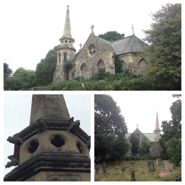
While fields in 1893, this area is now part of Hither Green Cemetery. It originally opened as Lee Cemetery in 1873 but with a much smaller size at the northern end of the current one. Like the Borough of Deptford cemetery we passed through in Grove Park, it was outside the jurisdiction it served, all on the Lewisham side of Hither Green Ditch. There are two impressive chapels, the Dissenters one (for Methodists and the the Baptists of Lee High Road and what is now Baring Road), was built by William Webster of Blackheath and was damaged during the last war and is slowly decaying.

The southerly end of what is now the cemetery had changed from farm land to allotments in the early part of the 20th century. The exact timing of the expansion of the cemetery into the allotments isn’t clear, it was probably just before or just after the start of World War 2, it was showing as allotments in the 1938 surveyed Ordnance Survey map. But by the time the children who died in the awful attack on Sandhurst Road School in early 1943, were buried the area had expanded. There is a large memorial to those who perished, something covered in a blog post that marked the 75th anniversary of the bombing in 2018. The crematorium in the south east corner was opened in the 1950s.

The 1893 boundary is relatively easy to follow on the ground through the cemetery as Hither Green Ditch has left a small valley close to the Lombardy poplars that border the railway.

Just outside the cemetery in 1893 was a small hospital, Oak Cottage Hospital; it had been built in 1871 by the local Board of Works for dealing with infectious diseases like smallpox and typhoid (1).  It was overtaken by events in that the Metropolitan Board of Works (which covered all of London) decided to open a series of fever hospitals as a response to a major Scarlet Fever epidemic in 1892/93, the health system was unprepared and there was a severe shortage of beds.  One of these was the Park Fever Hospital, later referred to as Hither Green Hospital; Oak Cottage Hospital was briefly considered as a possible alternative location (2).   Oak Cottage Hospital closed soon after Park Fever opened in 1896 (3).  It eventually became housing in the 1960s or 1970s.

Beyond Oak Cottage Hospital in 1893, were again fields, probably part of Shroffold Farm. On the opposite side of Verdant Lane (then Hither Green Lane) was North Park Farm, about to be ploughed under by Cameron Corbett. The Lee Lewisham boundary continued to use Hither Green Ditch which was to remain visible until the development of the Verdant Lane estate in the 1930s. This section is pictured below, probably soon after the Corbett Estate was completed around 1910.

In addition to the Ditch, there were a pair of long gone boundary markers, one was just to the north of the junction of Verdant Lane and Sandhurst Road, perhaps at the point one of the confluence of two of the branches of the Ditch; the other where it crosses St Mildreds Road – again a possible branch of the Ditch that would have been obliterated by the railway.

St Mildreds Road hadn’t existed when the Ordnance Survey cartographers had first visited in the 1860s. While the church of St Mildreds had been built in 1872, even in 1893 only homes at the Burnt Ash Hill end had been build, including another of the homes in the area of E Nesbit in Birch Grove.

The boundary went under the railway close to what was a trio of farm workers cottages for North Park Farm, which are still there at the junction of Springbank Road and Hither Green Lane.

The boundary continued to follow Hither Green Ditch – it wasn’t just a Parish boundary at this point, but a farm boundary too – on the Lewisham side, Hither Green’s North Park Farm, which was mainly on the other side of the railway and was sold at around the time that the land was surveyed and would form the Corbett Estate. On the Lee side was Lee Manor Farm, which is pictured on a 1846 map below (right to left is south to north, rather than west to east) and Hither Green Ditch which had several small bridges is at the top.  There were several boundary stones and markers along what was broadly Milborough Crescent and Manor Lane.  There was then a sharp turn to the east along what is now Longhurst Road.

The confluence of Hither Green Ditch with the Quaggy was in a slightly different place in 1893, then it was more or less where 49 Longhurst Road is now located; it is now around 40 metres away on a sharp corner between between Manor Park and Longhurst Road, as pictured below.

We’ll leave the boundary of Lee and Lewisham here for now following what is now the Quaggy into Lewisham in the next instalment.

This series of posts would probably not have happened without Mike Horne, he was the go to person on London’s boundary markers, he had catalogued almost all of them in a series of documents. He was always helpful, enthusiastic and patient.  He died of a heart attack in March but would have loved my ‘find’ of a London County Council marker in some undergrowth on Blackheath, and would have patiently explained the details of several others he knew to me.  A sad loss, there is a lovely series of tributes to him.

Notes

  1. Godfrey Smith (1997) Hither Green, The Forgotten Hamlet p54
  2. Woolwich Gazette 02 June 1893
  3. Smith op cit p54

Picture Credits


Beating the Bounds of Lee, Part 4 – Chinbrook and Downham

During the 2020 Coronavirus lockdown Running Past has been following the boundary of Victorian Lee before it was subsumed into Lewisham, aided only by a Second Edition Ordnance Survey map surveyed in 1893 and a fair amount of local knowledge. Posts have taken us in stages from Lee Green to Winn Road, appropriately passing Corona Road en route; the second took us through Grove Park, crossing the never built Ringway and the previous one through Marvels and Elmstead Woods leaving the boundary on the edge of Chinbrook Meadows allotments – and it is on to the Meadows that we now proceed.

This section is marked by the red dots on the adjacent map.

At around the point of a kissing gate, at the top of a steep hill down into Chinbrook Meadows the 1893 and 2020 variants of the boundary of Lee diverge.

The current variant of the boundary heads down into the lovely Chinbrook Meadows; it wasn’t always like this when the farmland became a park, the Quaggy was hidden. A blog post from a few years ago, covers its rejuvenation in 2002. The now Bromley and Lewisham border largely hugs the bottom of the railway embankment coming in from Elmstead Woods.

The 1863 version of the boundary crosses the railway in what is a deep cutting at this point, and emerged in what was then a small field and is now part of the smaller southwestern field of Chinbrook Meadows following the fences to the rear of the gardens of Portland Road until the Quaggy is again reached (further upstream than when covered in earlier in the circuit of Lee).

The 1893 boundary followed the Quaggy for around 100 metres until a confluence with the Border Ditch underneath the railway embankment. The ‘border’ in Border Ditch appropriately refers to the boundary we are currently following. When we followed Border Ditch as part of the tracking of the Quaggy and its constituent tributaries, the Ditch in Chinbrook Meadows was in a poor state but there were plans for a sustainable urban drainage system to be incorporated into its flow. Alas, this seems not to have materialised and the watercourse looked decidedly uninviting during lockdown – the photographs of its latter stages are from the initial visit in 2016.

Border Ditch has an even shorter flow than the Quaggy within Chinbrook Meadows – it emerges from culverting in a way that is more reminiscent of a drain than a stream.  As had been the case in the summer of 2016, there was little sign of movement in the ominous looking muddy water. 

The Ditch continues upstream and seems to have marked the border until the 1991 proposals came into force, although as was noted in the post on Border Ditch there were several minor re-alignments of the Ditch and the boundary over the years

Over the other side of the physical boundaries of the railway, which required a significant detour, Border Ditch only appeared as a field boundary on the 1893 Ordnance Survey map. It is now not only the border between Bromley and Lewisham but between the private sector semis of the former and the social housing of the latter. Traces of water were difficult to find in lockdown in the normally still flowing division between the two.

Streams, even quite small ones create valleys and out on the main Burnt Ash Lane the dip is noticeable and there lies both the current and 1893 variants of the boundary. The photograph above probably dates from just after the map was drawn, is of what was then a bridge and is looking towards Bromley.

Burnt Ash Lane was a name that once continued from here to the junction with St Mildred’s Road, but the it was renamed in ‘honour’ of the Lords of the Manor – the Baring Family. At the time they bought the Manor of Lee at least part of the Barings money was coming from an enslaved estate in Montego Bay in Jamaica. John Pound built much of Victorian Grove Park, on Northbrook/Baring land, naming the pub after them – the lovely Baring Hall.

We’ve strayed 400 metres away from the boundary putting the street name into some context, so back to the border, Border Ditch. The 1893 Lee (now Lewisham) – Bromley border continued westwards across fields to a three-way split in 1893 with Lewisham providing the third part of the trio. During the 19th century there had stood, according to F H Hart, ‘a tall round-top oak tree, a land mark from Lee Church’ at the junction of Lee Terrace and Brandram Road. It seems that this may have been lost by 1893, as this point was marked with a boundary post. In 2020, it is part of one of the dozens of largely access roads to garages in the area made largely redundant by the increase in car size, this one behind Welbeck Avenue.

The redundant access road is the course of Border Ditch which continues another 50 metres or so to a source in what is now some school playing fields. A small pond was marked in 1893. Oddly for such an elevated situation, close to the watershed between the Quaggy and Ravensbourne catchments, this was a small World War 1 airfield, Grove Park Landing Ground.

On the other side of the redundant track to redundant garages is the edge of one of the larger London County Council (LCC) estates, Downham, which was built in the late 1920s and early 1930s. The name doesn’t have any local links, rather it was that of a Chairman of the LCC just after World War 1.

The Lee – Lewisham boundary of 1893 was through fields, the boundary following what were then the hedges of field edges not marked in any way by posts, markers or marks on trees. Despite the transformation of the area between the World Wars, the street pattern still at least partially follows the field patterns. The former Lee – Lewisham boundary was follows the middle of what is now Geraint Road; like many boundaries that follow roads, it’s marked by white paint. The 1893 boundary then bisects Ivorydown, the name of a former field in this area, to reach Downham Way.

We will leave the boundary there for now because on the other side the nature of what is followed changes from field edge to hidden stream.

Credits and Thanks

  • The Ordnance Survey Map is via the National Library of Scotland on a non-commercial licence.
  • The black and white photograph of Burnt Ash Lane was originally used in the post on Border Ditch on the basis of a creative commons from this site, although the photograph library with it seems to have been deleted.

The series of posts on the Lee boundary that this post is part of, would probably not have happened without Mike Horne, he was the go-to person on London’s boundary markers; he had catalogued almost all of them in a series of documents. He was always helpful, enthusiastic and patient. He died of a heart attack in March but would have loved my ‘find’ of a London County Council marker in some undergrowth on Blackheath during 2020’s lockdown, and would have patiently explained the details of several others he knew to me. A sad loss, there is a lovely series of tributes to him via this link.

The Long Good Friday & the Camouflaged Pub

The demise of some pubs is felt strongly by local communities, by their former regulars and often by those who were occasional drinkers but perhaps saw the pub as part of their community – their passing is regretted and the mere mention of their name provokes fond memories.  But for a pub which started life as the ‘Northover’ on the south corner of the junction of Northover and Whitefoot Lane  these rose-tinted reminisces proved harder to find, although not impossible, as we’ll return to later; a comment on a local blog described it as the ‘late unlamented Governor General’ (its latter name) set the scene.

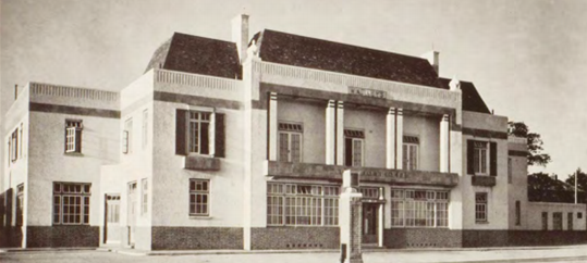
The pub opened around 1937 as the Northover; not that much imagination in naming a pub after the street it was sited on.  It was a striking, large building on a big plot designed by the firm A W Blomfield for Watneys.  Blomfield was a well-established architectural firm, the founder made his name as a church restorer – his work included substantial alterations to what was then St Saviours, Southwark – now the Cathedral and his staff included for a short period a very young Thomas Hardy. Arthur Blomfield had died a generation before the pub was designed though.

govgen4

The pub is clear about 40% of the way up on the right hand side of the 1937 photograph  from Britain from the Air website that was taken around the time it opened.  Beyond it are the well planned lines of the Corbett Estate dominating the rear of the shot and the local authority housing of Waters Road the mid ground.  The open ground around the middle of the shot was to become the Excalibur Estate a decade later.

The location of the pub was on the edge of the Downham estate which had been developed from the 1920s, there was an excellent post on the estate in the Municipal Dreams blog.  The first and then largest pub in England, the Downham Tavern, had been built in 1930; the Northover was one of the second phase of community facilities which included the library and swimming pool, whose original incarnations were also opened in 1937.

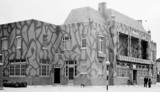
It was in a prominent location and as the Britain from above shot showed, highly visible from above; as a result it would have been vulnerable to attacks from the Luftwaffe – so some attempts were made to camouflage the pub during World War Two – they clearly worked as the pub survived the war intact – remnants of the camouflage remained into the 1970s.

It is not clear when the name change happened, although the logic is clear – it was a reference to the rich and prominent local Forster Family, who lived at Southend Hall, which was at what is now the junction of Whitefoot Lane and Bromley Road.  Henry Forster had been ‘elevated’ to the peerage in 1919 and was Governor-General of Australia between 1920 and 1925.  He died in 1936.

govgen5The pub’s only real claim to fame was that it was that it had a small ‘part’ in the 1979 gangster movie ‘The Long Good Friday’ (poster – Wikimedia Commons) which starred Bob Hoskins and Helen Mirren, which the picture to below (source – the fantastic Reel Streets) is a ‘still’ from. Unlike Bob Hoskins, where the film became a launchpad for a successful career, the Governor-General faded back into obscurity and local semi-notoriety.


govgen3

Other on line references are very few and far between, the Governor-General appears in several message board discussions of ‘rough’ pubs where fights were a regular occurrences and there was even a strange suggestion that the pub’s name change followed its purchase by Danny LaRue.  While LaRue certainly owned other pubs and hotels, such as the Swan at Streatley on the Thames, and the upmarket hotel Walton Hall – owning a boozer on the edge of a council estate is probably unlikely.

There have been a few Facebook ‘threads’ on the pub including several relating to this post; the SE London Memories Group which started with its reputation claiming it ‘used to be a drinking hole for most of South East London’s underworld.’  Many remembered this aspect of the pub’s past with comments such as – ‘Northover was the sort of pub where you wiped your feet on the way out and ordered a fight at the bar along with your drinks.’ Someone else called it a ‘pint and a fight’ pub.  One person remembered their father returning home, rather shaken, after someone he had been standing next to at the bar was threatened with a crossbow.

One former employee described it as ‘a dump …. nothing but punch ups, (the) public bar was like a wild west saloon! ’  It was pointed by someone else though out that most of the pubs in the area had fairly similar reputations.

But many more had fonder memories – there was a function room at the back which several had held their weddings receptions, it was often packed out on Friday evenings when there were rock & roll and rockabilly bands and often discos; and, for the more refined, there were dinner dances there too.  It was the venue for football and other club ‘do’s’ too.

There were memories of the two worlds colliding too – there was a recollection of a mass brawl following a talent night being gate-crashed in the 1970s.

On a different thread , the pub is remembered as the location of the first, underage, pint – trying to and probably failing to look 18, and younger memories of sitting in the garden with just lemonade and crisps where the salt came in a blue packet (presumably before it was done on a retro basis).  Similar recollections came on some of the threads relating to this post too.

The filming of the Long Good Friday is remembered too – apparently Bob Hoskins had a kick about with several local teenagers, and generally being friendly towards locals; he may have received the attentions of a number of the local young women… One of the part of the filming went slightly wrong in that an actor was meant to be swung around seem to hit a poster on a wall, there was apparently a mixture of fake and real blood when it was salvaged as a souvenir.

The pub car park was the scene of a rather bizarre incident in the late 1970s when a large block of ice deposited from an aeroplane smashed through a car taking the engine with it!

The pub closed in the early 1990s – a pattern followed by several others on the edge of Downham – the Garden Gate, now a McDonalds, just off Bromley Hill and the Green Man, demolished and now a housing association office.  These days the site would no doubt have been developed for housing but around 2000 it opened as a petrol station, initially, as Q8, latterly a Shell filling station

image

As with other ‘lost pub posts’ on Running Past, it would be good to be able to add in some other memories into the post. If you worked there or drank there tell your story – who were the characters that were regulars at the Governor-General? What about the landlord, the staff, the atmosphere, recollections of the friends, the memorable nights, (given its reputation) perhaps the fights and any memories of the filming of ‘The Long Good Friday.’  You can use your Facebook or Twitter login to comment here, first comments get moderated before they appear though.  If you found the post via Facebook, you can write your recollections there.  I will update the post with the memories.  Please don’t put anything libellous or that might offend others though…..