Tag Archives: Old Road

Bankwell Road – Edwardian Migration & Employment

In the relatively recent past Running Past has looked at migration to several Lee streets based on censuses soon after the first residents moved in – the working-class Robertson Street (now Brightfield Road) and the middle-class middle section of Southbrook Road both in 1881.  Similarly, we have looked at the occupations of those first occupants – looking at Ardmere Road in Hither Green and parts of Springbank Road, along with the 1930s parts of Old Road and the Verdant Lane estate.

We turn our attention to a street that was built somewhat later than all but the last two – Bankwell Road whose homes were completed in early 1909. It is a small road running from Lee High Road to the northern entrance to Manor House Gardens. The street is in what was the grounds of Lee Place.

Lee Place had been one of the larger houses in the area from the 17th century until it was demolished at the end of Benjamin Aislabie’s lease in 1824.  The former estate was sold in plots with the area bounded by Old Road and Lee High Road (that section was initially referred to as New Road) being divided into three – see map above.  The easterly end was developed for shops and Lee Working Men’s Institution in the late 1870s; the westerly end was used as an orchard and kitchen garden for Pentland House before becoming Arts and Crafts style flats on Old Road and a shopping parade on Lee High Road – Market Terrace.

The section in middle now has Bankwell Road at its centre.  It was a field until the beginning of the 20th century.  The eastern frontage onto Lee High was developed as shops next to those developed in the 1870s around 1910, on the opposite side of Bankwell Road was a cinema, Lee Picture Palace, run and almost certainly built by James Watt.

While Watt was a prolific builder, both in his own right and as a contractor on the Corbett Estate, he didn’t build the houses on Bankwell Road. That was a firm called Hatch and Hatch who were based at 62 Rushey Green, in the main they were auctioneers but did some speculative building work.  They were owned by Robert Frarey who also had a builders’ merchants called Catford Building Supply Association who were based at 161 Rushey Green – a site still in the same business trading as Catford Timber (1).    

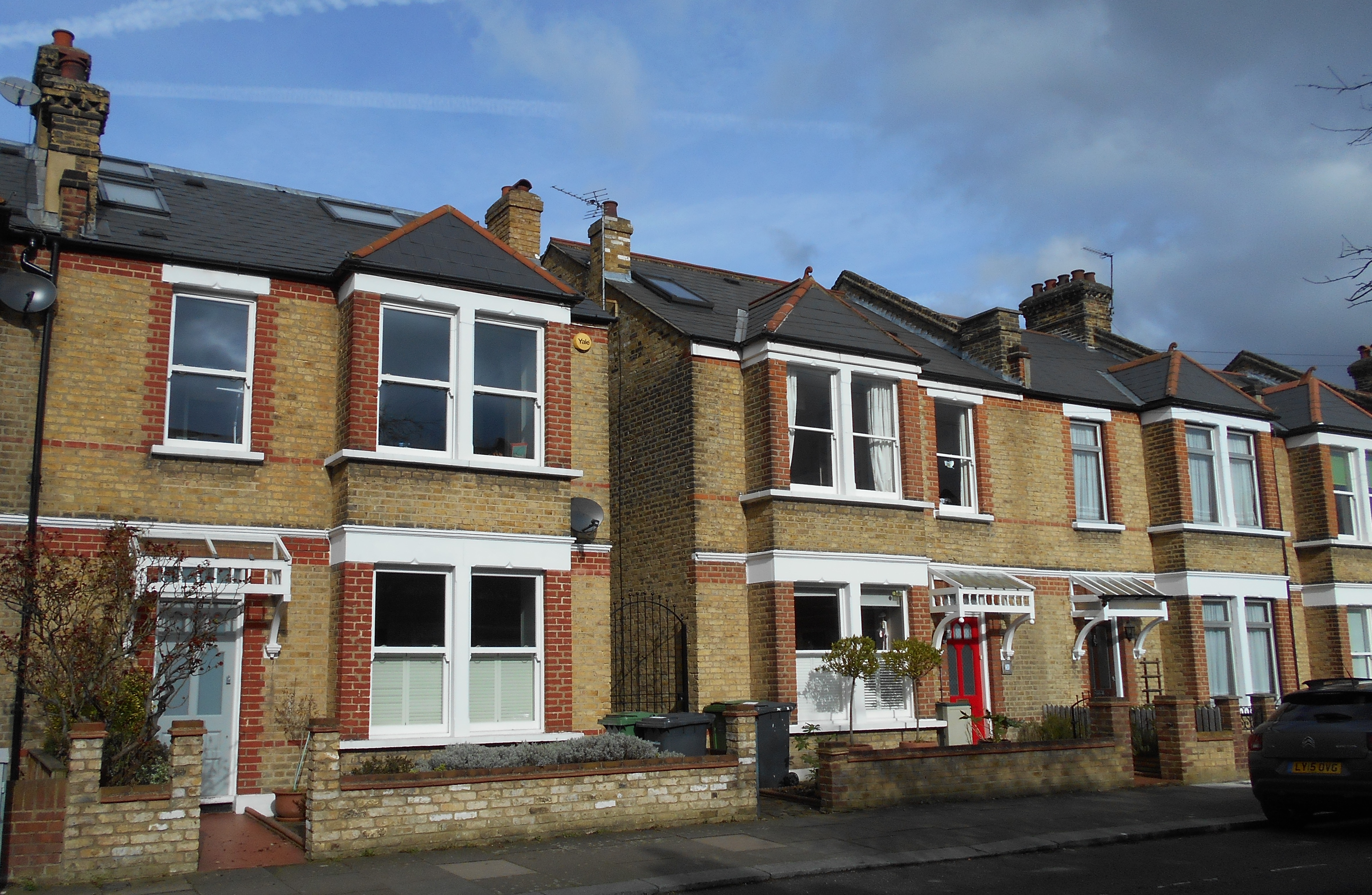
The houses seem to have been completed in early 1909 with number 3 being used as a show house as there was a sale at auction of furniture from there (2).  Number 3 was one of four houses on that side of the road that were to be sold by auction in March 1909 on 99-year leases (3).  The houses on the western side, pictured below, were completed a few months later (4). 

There were a lot of problems for the tenants of the houses in the months after – the owner was still Robert Frarey who had presumably failed to sell the homes in March 1909 (5).  Frarey was summoned for failing to supply water to numbers 6 and 8 (6).

There were issues too with delays in sorting out pavements, the road surface and street lighting which prompted a letter from one of the residents of the street to the local press in May 1909 when the street still had builders materials scattered about and to reach the front door in wet weather almost required ‘top boots or a raft’ (7).  While the Borough of Lewisham stepped in and adopted the road, they found it difficult to get the money out of the owners (8). 

The reason for this was that Hatch and Hatch were teetering on the edge of bankruptcy – there was a creditors’ meeting in July 1909 where it became clear that one of the reasons for his debts was his inability to ‘realise property’ – presumably not selling on the homes in Bankwell Road and land owned in Wimbledon (9).  It seems that by August 1909 the houses had been sold on, probably at a loss, by the Receivers (10).

One of the houses, probably number 12, described as a ‘pre-war villa’, was for sale for just £895 in 1927 (11).

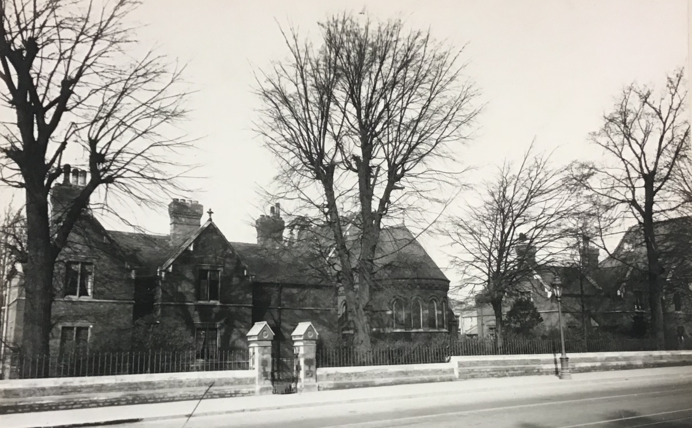
The eastern side of the street with a then dairy at the corner is pictured below from early in their life.

So, who were the initial tenants many of whom had to live on a building site to start with?  The 1911 Census was taken a couple of years after the houses were completed.  A surprisingly high number of the 13 houses were empty (5, 6 & 11) when the enumerators called.

They were in the main young professionals with young children, the average age of the adults was 33. There were a couple of house shares – one three siblings (the Stevens at number 3) and the other two sisters and one of their husbands (the Trivett/Venner household at 7)..

Several were probably employed in local businesses – Edwin Linden at number 2 was a Clerk at a Cat and Dog Food Manufacturers.  This may well have been Perfecta Foods which had been bought by Arthur Chilton King and was to become Chiltonian biscuits soon after. (There is a short post, which needs some updating from the early days of Running Past). The Linden family was to stay at number 2 until the late 1990s.

Also probably working at Chiltonian was Percy Jarrett from number 9 – he was listed as manager in a biscuit factory.  Other trades included a provisions merchant, an electrical engineer, a couple of assistant teachers, a postal sorter, perhaps at Lee Sorting Office in what is now Woodyates Road, a Drapers’ Manager a Clerk for a Tent and Sail Maker – perhaps for John Edgington & Co who were to move in 36 Old Road after the war.

None of the married women worked but the Stevens sisters were both employed at a Telephone Exchange, perhaps the Lee Green one, then in Gilmore Road; the only other working woman was one of the Assistant Teachers, Grace Venner, who lived at number 7. 

Before looking at the census records, the assumption had been that most of the adults would probably have been second generation migrants with parents having moved from elsewhere in the country to London.    That was true of a few such as Draper’s Manager, Alexander Miller who hailed from Sydenham with a father from Poole in Dorset. 

Madeline Trivett at number 7 was from Bermondsey and her teacher sister from Canning Town, three doors away Edith Howland seems to have come from Wandsworth – a lodger there was from what is now Tower Hamlets.  So, only five out of twenty-six were born in London.

As the map shows, there was quite a spread across the country (there are three outliers all from Aberdeen, the Stevens siblings at number 3, which aren’t shown).  Compared with the working class street of Robertson Street here are fewer Londoners and fewer from East Anglia and areas close to London.  Compared with the wealthier early occupants of Southbrook Road, where 14% have been born in parts of the Empire, none fell into this category in Bankwell Road.   As has already been alluded to there were considerably fewer Londoners too. 

Of the children, unsurprisingly given the age of their parents most were local 10/14 were from what is the current Borough of Lewisham and three of the others within 5 miles.

It is only 10 houses so not too much can be inferred from it, but it is interesting that in one new street most came from outside the capital – migration to the city was still a significant feature.

Notes

  1. Kentish Mercury 16 July 1909
  2. Kentish Mercury 26 February 1909
  3. Kentish Mercury 05 March 1909
  4. Kentish Mercury 14 May 1909
  5. Kentish Mercury 05 March 1909
  6. Woolwich Gazette 11 June 1909
  7. Kentish Mercury 14 May 1909
  8. West Kent Argus and Borough of Lewisham News 19 October 1909
  9. Kentish Mercury 16 July 1909
  10. Kentish Mercury 13 August 1909
  11. Sydenham, Forest Hill and Penge Gazette 8 July 1927

Credits

  • The photograph of the dairy and the eastern side of the street is used here with the kind permission of Bill Bowyer, it remains his copyright
  • Census and newspaper data is via Find my Past (subscription required)
  • The Ordnance Survey map is part of the collection of the National Library of Scotland, and is used here on a non-commercial licence
  • The migration map has been created with Google Maps

Brightfield Road – the Street with Two Names (Part 1)

Streets having their names changed is nothing unusual – we’ve covered it a couple of times before with Dermody Road (formerly Hocum Pocum Lane), Waite Davies Road (formerly (Butterfield Street). Similarly, on the other side of Lee High Road the bottom of Dacre Park was previously known as Turner Road. Like the second two examples, there is fading evidence of a painted street sign bearing the earlier name. However, it isn’t as easy to decipher the former name, Robertson Street, due to multiple layers of faint paint, re-pointing and a burglar alarm. In a pair of blog posts we’ll tell the history of the street – from its building to the present day.

The builder of the original part was someone we’ve covered several times before, John Pound, mainly in relation to his house building but also shops on Burnt Ash Road, pubs and Lee Public Halls. The street was built by Pound around 1862 (1), with applications made to the Board of Works that March for drainage connections. The land was owned by Lord Northbrook, although it doesn’t seem to have been farmed as part of Lee Manor Farm – it isn’t in the farm map of 1846 – and the estate seems to have retained the freehold post development (2) as permission was sought from Lord Northbrook’s agent for some work.

The homes were unlike most of those in the rest of the area at the time. The arrival of the railway in Blackheath had seen substantial homes with space for servants built to the north of Lee High Road. The function of these smaller houses was similar to those in Lee New Town – providing homes for the servants who didn’t ‘live-in’ and working classes of mid-Victorian Lee. There was another function too, large-scale housing development in what was then suburbia needed somewhere for the building labourers and trades to live in an era without cheap public transport. Pound seems to have done the same around Waite Davies Road and Summerfield Street for his brickworks in South Lee. It was a pattern followed by Cameron Corbett with houses in Sandhurst Road a few decades later.

Pound also seems to have built the neighbouring Hedgely Street – he made an application for sewer connections in 1868 (3).  The street was adopted and paved in 1871 at a cost of 4/6d on the rates for occupiers – not the landlord (4).

So, who were the early occupants?  We’ll look at the first 20 houses in the 1871 census, the first census they appeared in; while the numbers appeared as consecutive in the census reports it isn’t clear whether this was the case on the ground.  The numbering is now odds and evens. The shops have been ignored for now, but may be returned to in a later post.

The majority (52%) of heads of household were working in the building trade, mainly skilled trades with the remainder split between various forms of domestic service and other trades.  Relatively few of the women worked, but those who did, tended to be listed in the census as charwoman or laundress.  While not in in the houses reviewed in detail, elsewhere in the street there were farm labourers housed – presumably still working at either Burnt Ash, Lee Manor or Horn Park which were all still working at that stage.

Almost half of the houses were either home to two households or took in a lodger, there were some very overcrowded homes as a result – 13 lived at no 17 for example. Almost all the households had children.

A decade later the average number in each house was 6.7 (it had been 5.5 in 1871), mainly due to an increase in lodgers and shared houses.  More women were working, although the trades were mainly around washing, ironing and cleaning.  Male employment had changed little too, the majority working in the building trades.

Unsurprisingly, there was some crime relating to the street, a fair amount of it alcohol related. John Mahoney had to be removed by heavies from the Tiger’s Head for being drunk and aggressive. He then went over the road to what is now referred to as the New Tiger’s Head, but press reports called the Little Tiger, where he was arrested after falling asleep drunk. He then violently assaulted the arresting officer for which he spent 6 weeks in prison (5).

Robert Stow was found guilty of assaulting a police officer after being arrested for being drunk and disorderly outside the nearby Duke of Edinburgh – his defence was that he didn’t know it was a policeman and that he’d had too much rum to drink cut no ice with the magistrates.  He was fined 20/- or 2 weeks in prison (6).

Theft wasn’t completely absent though – Thomas Upton (23) a labourer from 19 Robertson Street charged with stealing 25 hens from Blackheath Park and then selling them in Greenwich.  He was sent to prison for 14 days (7).

The western side of the terrace backed not onto the Quaggy, as it does now, but onto a path from that broadly followed what is now Aislibie Road.  After the floods in 1878 and probably also to allow better development of the land that was to form Lampmead Road, the Quaggy was deepened, straightened and took the route of the path. The differences are clear between the 1863 (top map below) and 1893 visits of the Ordnance Survey Cartographers.

The extension of the street to the northern side of the Quaggy seems to have happened around 1885 following the piecemeal sale of the Lee House estate. The builder may well have been George Mitchell; he made the application for connecting the new homes Brightfield Road to the existing sewers in what was still referred to as Robertson Street. John Pound asked for money for the connection (8). It is assumed that these would be the homes that are now numbered 109 to 127 Brightfield Road (some of which are pictured below), but could have been those to the south over the Quaggy.

Three years later a decision was made by the Metropolitan Board of Works in March 1888 to change street names in the area.  It seems that Lampmead Road was created, it had originally been a dog-leg of Lenham Road going towards Lee High Road.  The biggest change was in relation to Brightfield Road – from 1883 it had run from Old Road and then dog-legged around to the new homes built by George Mitchell.  The section from Old Road now became Aislibie Road and Brightfield Road, while shortened to the north took expanded over the river and Robertson Street was no more (9). In addition to the remains of the painted sign, a stone one remains and is now part of a garden wall.

The new Brightfield Road had changed a lot by 1891 compared with the last census for Robertson Street. John Pound’s building work had finished in the area and only 8% of the heads of household at the eastern end of the street were working in the building industry, just over a third were servants – mainly jobs relating to horses with the remainder a wide variety of manual jobs. As was the case a decade earlier a lot of the women worked – mainly as dressmakers and laundresses. Most households had children and most of the houses were either shared or homes to lodgers too – overcrowding remained, although it was less bad than in 1881 – the average was 5.8 rather than 6.7 a decade earlier.

There were a few sales of the houses which seemed to be all tenanted over the next few years. In 1892, 111 -125 (odds) were up for sale at auction. These are the larger houses backing on to Manor House Gardens, then let as a military crammer school before the House and Gardens were sold to the London County Council in 1898. The particulars of the sale of the houses in Brightfield Road noted the proximity to Lee and Blackheath stations. Each house was ‘conveniently arranged for two families. Let to very respectable tenants at 12/- a week.’ There were unexpired leases of 92 years (10).

Three years later some more of the later houses, 75-79 which were adjacent to the original houses were sold – they were advertised as being on long leases, having a weekly rent of 12/- and an annual ground rent of £5 (11).

The change in name didn’t stop crime relating to the street in 1897, Emma Agate was arrested for theft of a large number of garments from Lee Public Halls Steam Laundry (in early 2021 home to Travis Perkins off Holme Lacey Road) where she worked as an ironer, she was found with a number of pawn tickets. She denied the charges but was remanded in custody (12).

There were a couple of bigamy cases – William James was charged with bigamously marrying Mary Bator of number 61 in 1889 (13). Four years later, Walter Garland admitted to a bigamous marriage to Alexandra Taylor of 60 Brightfield Road (14).

We’ll leave Brightfield Road at the end of the 19th century, returning in the second part to cover the 20th century and beyond.

Notes

  1. Kentish Mercury 22 March1862
  2. Kentish Independent 01 June 1872
  3. Kentish Independent 10 October 1868
  4. Kentish Independent 16 December 1871
  5. Kentish Mercury 18 June 1870
  6. Kentish Mercury 30 October 1875
  7. Kentish Independent 10 April 1886
  8. Kentish Independent 02 May 1885
  9. Kentish Mercury 9 March 1888
  10. Kentish Mercury 25 July 1892
  11. Kentish Mercury 29 September 1895
  12. Woolwich Gazette 27 August 1897
  13. Kentish Mercury 13 June 1890
  14. Woolwich Gazette 27 April 1894

Credits

  • The maps are on a Non-Commercial Licence via the National Library of Scotland
  • All the census and related data came via Find My Past (subscription required)
  • The photo of the stone sign is courtesy of Frederic Heffer

The Post Christmas Blitz on Lee Part 2 – 29 December 1940

In the first part of this post we looked at the post-Christmas Luftwaffe attacks on 27 December 1940 on Lee which saw numerous bombs dropped and homes destroyed on Aislibie Road, the misspelled road, named after Benjamin Aislabie – slave owner, awful cricketer and tenant of Lee Place.

While there was a lull the following evening, it seems that the Luftwaffe were just gearing up for an even bigger raid on 29 December, the aim of which seems to have been to put the fire services under a level of pressure that they would be unable to cope with and see London burning.

The attacks were much more concentrated in a small number of streets between Lee High Road and and Manor House Gardens. Most were incendiaries, and along with a few high explosive bombs, were dropped in a few minutes around 8:15 pm.

As we found with the post on the first night of the Blitz, it is worth remembering that not every incident was reported to the Air Raid Precautions (ARP), some being just reported to the Fire Brigade but others never going through official channels. One of the pages of incidents for the night of 29/30 December 1940 is show below.

The first attacks of the night in Lee started at around 7:25 pm in Blessingham Road, when a high explosive bomb hit the back garden of number 38. Elsewhere on the street another high explosive bomb injured two people. The street was to be decimated by a series of V-1 flying bombs later in the war and was developed, initially as prefabs, and in the early 1960s, as the Mercator Estate.

Fifty minutes later, Lee was on fire, the ARP logs note several dozen incendiaries being dropped at the same time, so we’ll look at the attack on a street by street basis. Aislibie Road (pictured below) which had suffered badly two nights before, was again hit. It was different houses this evening with 5, 13, 26, 30 and 39 all being bombed with roofs and upper floors damaged by the incendiary bombs, none were destroyed though.

Parallel to Aislibie Road, and the location of a devastating V-1 flying bomb three and a half years later, is Lenham Road which saw 5, 7, 10 and 28 all hit by incendiaries. The fires were successfully dealt with by local ARP and Fire Wardens.

Incendiary bombs rained down on neighbouring Brightfield Road with 32, 34, 42, 43, 49, 63 and 83 all hit by them (some are pictured below) – the fires were put out by wardens and the inhabitants, but many of the roofs were damaged.

Elsewhere in the neighbourhood, the roof and upper floors of 24 Lampmead Road were damaged, as was 4 Hedgley Street. Taunton Road saw at least two attacks – number 60 was slightly damaged and 2 Thornhill Cottages saw its roof damamged. Thornhill Cottages was a terrace at the eastern end of Taunton Road between Burnt Ash Road and Hedgley Street seemingly on the present Sainsbury’s site.

At the opposite end of Manor House Gardens, 2, 44 and 61 Old Road plus Pentland House (pictured below) were all hit but Fire Wardens managed to deal with all four fires.

A little further along Lee High Road, number 345 was hit by another incendiary; ironically it had been a fire station up until 1906 when the one on Eltham Road opened, it is now a solicitors. The roof seems to have been damaged, and assuming that there was no damage on other occasions during the war, a central turret there was destroyed (there is a pre-damage photograph in the post on the fire station).

There was an explosive and incendiary combination dropped on Dacre Park at the same time and there were ‘several .. casualties in the road’ as a result.

Around fifteen minutes later at 8:30, a high explosive bomb hit Lee High Road between Old Road and Lochaber Road – there 5 casualties, including an ARP warden, with shrapnel damage to almshouses’ boundary wall that is still visible (along with a fading direction sign to an air raid shelter). The ARP warden was Henry Cottell of 41 Manor Lane Terrace who was to die later that evening in Lewisham Hospital – it was a house that seems to have been lost to the construction of Wolfram Close. Henry left behind two adult daughters and his wife Ann, who were there when the 1939 Register was collected.

Also at 8:30, Chiesman’s store repository at 87 Old Road was hit by a high explosive and incendiary combination – the ARP log noted that the repository was on fire. We’ll return to this incident later in the post.

One of the ARP Fire wardens for that part of Lee that night was Phyllis Noble (later Willmott), who lived at 49 Lampmead Road with her parents and grandparents. In the aftermath of the incendiaries being dropped, she and her brothers, who were also ARP Wardens, grabbed stirrup pumps, buckets and sandbags. ‘Incendiaries seemed to be everywhere, but so too were numerous fire watchers like ourselves.’ (1)

The first fire they dealt with was at the almshouses that stood at the corner Lampmead and Lee High Roads (pictured above) where a room had caught fire. They put out that and another in the neighbouring Methodist church, now the New Testament Church of God. Phyllis and her brothers spent the next few hours putting out fires in locations that didn’t even get a mention in the ARP log chasing ‘up and down stairs in the tall Victorian houses in the High Road.’ They reached Old Road and Chiesman’s Store depository by around midnight (2)

“As the red glow in the sky told us, there were still plenty of fires raging, including one in the furniture depository nearby. We went along to see if there was anything we could do there; giant tongues of red and gold flames were shooting skywards from the glowing building and clearly this was not work for us, in any case the firemen had already arrived.”

Had the Fire Brigade arrived earlier they may have been able to save 87 Old Road but it was largely destroyed.

Lee was probably only a stopping off place for the Luftwaffe as they headed towards the centre of the city. Later in the evening incendiaries rained down on central London in what was described as the Second Great Fire of London, the iconic picture of St Paul’s Cathedral amidst the smoke was from that night as 160 died and hundreds of buildings were destroyed in the capital.

Notes

  1. Phyllis Willmott (1988) Coming of Age in Wartime p50
  2. ibid

Credits

  • Most of the information for this post comes from the Lewisham ARP Log – it is a fascinating document, which is part of the collection of Lewisham Archives. It isn’t a complete record – some incidents were reported to the Fire Brigade rather than the APR and some incendiaries were dealt with by residents or Fire Wardens without ever reaching the ARP service – this is particularly the case on busy nights such as this.
  • The photograph of St Paul’s is via a Wikipedia Commons
  • The photograph of the Boone’s Almshouses and the page of the ARP Log are both from the collection of Lewisham Archives, both are used with permission and remain their copyright.

The Two Boone’s Chapels

Boone’s Chapel on Lee High Road is a impressive former church building on Lee High Road; it is one of only two Grade I listed buildings in Lewisham, the other being St Paul’s in Deptford. Less well known is that there is another Boone’s Chapel – about 500 metres up Lee High Road. This post looks at both of them starting with the listed variant.

‘…..a delightful little brick rectangle with stone trimming, two heavy round-headed windows on the front, equally heavy oval windows higher on the east, west and south, and heavy pediments on the same sides; octagonal cupola on the centre of the roof.’ (1)

Originally, there seems to have been a carved stone angel above the door but supports rusted away it was lost in a storm, probably in the early 19th century.

Christopher Boone had bought Lee Place around 1670 following the death of George Thomson. The Chapel was built for the Boones; it has been attributed to Wren, but was probably designed by Robert Hooke and construction finished around 1683, along with some almshouses built next door on the High Road. We will return to these almshouses, along with the Merchant Taylor’s almshouses, behind, at some point.

Between 1683 and 1877 the Chapel was used as a place of worship for the Boone family, the almshouse residents and as a chapel-of-ease for St Margaret’s Parish. After Christopher Boone died in 1686, the Chapel was also used as a mausoleum for him and his wife. The burial place in a chamber beneath the floor was discovered during restoration works on the Chapel in 2006.

When the Chapel was built, it was close to the gate to the estate; at this stage the main road broadly followed the course of Old Road. There were regular accidents on the sharp bend with carts going to and from London markets. During a service in 1813, when St Margaret’s was being rebuilt, a horse and cart failed to navigate the corner and the horse ended up inside the Chapel!

While it was one of the first London buildings scheduled for preservation, it had largely fallen into disuse by the end of World War Two. In 1999 Blackheath Historic Buildings Trust was set up to try to restore the Chapel. The initial plan involved some cross subsidisation with a block of new almshouses at the back. However, alternative funding streams through the National Lottery Heritage Fund were found that meant that this wasn’t needed and the Chapel was restored, with work being completed in 2008. The Chapel is now home to an architectural practice although is regularly open to the public including during Open House weekend.

Before moving up Lee High Road, it is worth pausing briefly by the adjacent wall, which is part of the Grade I listing, while the listing mentions ‘3 brick and stone piers and ball caps’ what is probably more interesting is a very weathered coat of arms, that of the Merchant Taylors Company (2).

The ‘other’ Boone’s Chapel was described by Pevsner as ‘a neat new Gothic chapel ….. red brick, apsed, lancet style.’ (3) It was designed by Edward Blakeway I’Anson, who was the third generation of the family practicing in a City of London architectural firm.  The replacement almshouses were built either side of it – as the photograph below shows.

This second Boone’s Chapel dates from around 1875. The land will have been the first part of the estate of Lee House to have been sold off; there had been attempts to sell the whole estate in the early 1870s, but in the end only a narrow strip alongside Lee High Road was sold; 344 to 368 were built in the late 1870s and Blenheim Villas, 334 -342 a few years earlier (4).

While it was generally referred to locally as Boone’s Chapel, it was consecrated as St John the Baptist. It was later referred to as ‘a missionary outpost of the parish (of St Margaret’s) where the rector’s volunteer workers came to do good with the Lee villagers on whom curates also learnt their craft.’ (5)

It was slightly odd that this part of Lee had continued to be ministered to by St Margaret’s parish even when the ‘new’ parishes of Christ Church (1854) on Lee Park, Holy Trinity on Glenton Road (1863), St Mildred’s on the South Circular (1872) and the Church of the Good Shepherd on Handen Road (1881) were carved out of it. It was connected by a small isthmus of land between Old Road and Boone Street.

The parishioners included some of the Noble family from Lampmead Road. We have covered the 1920s and 1930s childhood reminiscences of Phyllis Willmott (née Noble) a few times in relation to the Sunday Constitutional, trips to Lee Working Men’s Club on Lee Road and in interwar play.

She notes that the Nobles weren’t a chapel or church going family; her mother had a Methodist upbringing but went to the chapel a couple of hundred metres from their home as ‘social pleasures drew her, a chance for a word or two with friends and neighbours; the chance to sit back and remember the Sundays of her own childhood.’ (6)

Part of the joy of going seemed to be the dressing up in the ‘Sunday Best’ even if the clothes were from a jumble sale. Her mother put on ‘a slick of powder and lipstick and perhaps a new feather in an old hat or, for me, putting the latest find from a jumble which we persuaded ourselves we had succeeded in making “as good as new.”’ (7)

Phyllis’ brothers were choristers in the small choir, girls seem not to have been allowed to join. They occasionally sang solos, which guaranteed her mother’s presence (8). The social aspect of going to church was important – her Mother would chat to friends and neighbours outside and shake hands with the curate who would take the service (9).

Her parents seemed to have assumed that religion was ‘a good thing for young children but something they naturally grew out of;’ it seemed particularly helpful as it allowed supervised childcare on Sundays. Most of the other children in the Bible Class seemed be from the ‘posh’ side of Lee High Road, the Blackheath side, rather than the poorer streets to the south (10). This changed when the evangelical Harold Plumstead became curate and organised lots of activities using them as an opportunity to persuade the children to ‘see the light’ and ‘stand up for Jesus.’ (11). Despite the lack of church origin tradition within the family, Phyllis was confirmed when she was 13 (12).

It seems that the church was at least partially rebuilt in the 1920s suffering some limited damage during World War 2, although it reopened in 1947 (13). However, it’s temporary closure probably sounded the Chapel’s death knell as its congregation dispersed in 1952 (14). Its listing in Kelly’s didn’t change though, so while not used, it seems to have remained in the ownership of St Margaret’s. During the 1960s the church unsuccessfully sought to turn part of the site into a petrol station.

By 1975, Kelly’s Directory was describing it as a ‘Pentecostal Church’ although by 1980 the entry had changed to ‘Assemblies of God Emmanuel Pentecostal Church.’ They added the single story modern frontage completed in 1984. More recently there were unsuccessful attempts to demolish the entire site and rebuild the church with some flats (the unsanctioned demolition of most of the almshouses will be covered in a later post.)

Behind the single-storey frontage are the red brick remnants of the original church.

Along with the New Testament Church of God next door, the church seems popular with dense parking in neighbouring streets at the time of Sunday services.

Notes

  1. Bridget Cherry & Nikolaus Pevsner (1983) The Buildings of England – London 2: South p426
  2. Lewisham Leisure (1990) From The Tiger to The Clocktower
  3. Cherry and Pevsner op cit p426
  4. Lewisham Lesiure, op cit
  5. Phyllis Willmott (1979) Growing Up in a London Village p119
  6. ibid p119
  7. ibid p119
  8. ibid p121
  9. ibid p122
  10. Phyllis Willmott (1983) A Green Girl p40
  11. ibid p42
  12. ibid p43
  13. Lewisham Leisure, op cit
  14. ibid

Credits

  1. The Kelly’s Directory information comes from a mixture of Lewisham and Southwark archives.
  2. The black and white photograph of the 1875 variant of the church is part of the collection of Lewisham Archives, it remains their copyright and is used with their permission
  3. The photograph of the original Boone’s Chapel and almshouses is from The Proceedings of the Lewisham Antiquarian Society 1908 on a Creative Commons

Old Road & Beyond – A Walk Through Some of Lee’s Past

The area bordering Manor House Gardens has a rich and interesting history which Running Past has written numerous posts about.  This post was written to ‘accompany’ a walk organised as part of the 2019 Manor House Gardens Festival, it can be used to independently to walk the route (it’s a circuit of around a mile, which can be found here) or as virtual tour of the area.  The ‘walk’ is divided into sections which relate to the planned stopping points – each of which is full of links to other posts in the blog which will have more detailed information.

Some Background

Before it was enveloped by the city Lee was a village, a village with three centres – Lee Green, the area around St Margaret’s Church and Old Road, as John Rocque’s map from 1746 shows.

Lee remained largely rural until mid-19th century until the coming of the railways – Blackheath & Lewisham stations opened in 1849, Lee in 1866 and Hither Green not until mid-1890s (it was just a junction before that).

The mid-1860s Ordnance Survey map above shows how little development there was beyond Lee Green and to the south of Old Road; farms remained until the 1920s and 1930s, such as Burnt Ash and Horn Park.

The Manor House

Old Road was once home to a series of large houses, starting from the eastern end these were Lee House, The Cedars, Lee Place, the Manor House, Pentland House and The Firs – geography played an important part, it is on a small hill which would have offered impressive views to the east and south but were high enough to protect from flooding from the Quaggy and the now diverted Mid Kid Brook, which used to flow down Lee High Road.

Lee Place

The first of the country houses was Lee Place; Its building was the result of the death of Lord of the Manor, Brian Annesley who had a moated farm probably where St Margaret’s Lee School is now situated.  His later years are believed to at least partially inspired Shakespeare to write King Lear – there was happier ending than in the play though.  The estate split up on his death.

Lee Place (above) probably built by/for George Thompson – had links to the slave trade but is better known as a soldier and MP during the Commonwealth brother of Maurice who lived at Lee Farm. It was the home to the Boone family (it was their family chapel) for several generations but was let out from the mid-18th century.  Its last tenant was Benjamin Aislabie.

The estate was sold in 1824 as still has an impact on the current landscape as it was broken up into relatively small lots which were developed at different times.  It allowed too the straightening of Lee High Road – the straightened bit was known as New Road for several decades

The Manor House

Lee Farm was previously on the site, which moved to what is now the junction of Baring and St Mildred’s Roads in 1727 and became Burnt Ash Farm. The former farm was bought initially by the slave trading brother of George Thomson, Maurice and then by William Coleman who sought to re-create the lands of the old Manor for his nephew,Thomas Lucas, both were ‘merchants’ with strong links to the slave trade.

The Grade II listed Manor House was built on the site of the farm in 1770 by Richard Jupp for Lucas.  It was bought by Sir Francis Baring in early 19th century, whose family wealth also had its origins in the slave trade – used it as their near London base – the merchant on the maroon plaque is depressingly vague. The Northbrooks let in out during much of the 19th century

They sold the house as a library and grounds to the London County Council in 1898 opening to the public in 1902.  The Northbrooks owned much of Lee and their gradual selling off of their ‘estate’ in the latter part of the 19th century which shaped the current urban landscape.

Pentland House

Pentland House was built in early 1790s and is probably the oldest residential building in Lewisham – it is a close run thing with St Mary’s Vicarage though!  It has been added to considerably and rendered in the early 19th century when extended.

It was home to the rich, but not that significant Smith family, who sold to some more Smiths, who sold to some more Smiths (albeit with a prefix) – it became a Goldsmiths’ College hall in 1913 which stayed until the early 2000s.  It is currently a largely backpackers hostel.

Flats & Houses Opposite

The houses and flats opposite are a bit less grand – Bankwell Road & adjoining bits of Old Road – completed in 1908, possibly by James Watt – it was the central of three plots of land bounded by Lee High Road and Old Road – as the 1890s Ordnance Survey maps below shows.

The eastern of the plots are Arts & Crafts style flats which are a bit out of kilter with rest of area.  The land they were built on had been part of Lee Place – the house itself was on this part.  The land was bought as an orchard and kitchen garden for Pentland House with the flats & Market Terrace on Lee High Road built in the mid-1930s.

Before moving on worth reflecting on the library, the park and indirectly the rest of the current urban landscape was paid for by the slave labour in the plantations of the Caribbean owned or traded by those that lived here and over the road.

On the way to Lochaber Hall at the first house on Manor Lane Terrace look at the wall – the remains of a sign pointing towards air raid shelters in Manor House Gardens (more on that later).

Lochaber Hall, the Firs, Holy Trinity

Lochaber Hall

If think Lochaber Hall looks like a church hall you’d be right, it was originally church hall for Holy Trinity in Glenton Road (pictured below).  The church was destroyed in the Blitz and is now Callaghan Close (almost opposite the Telephone Exchange) and named after the 1970s Prime Minister who lived in Blackheath.

The Hall was designed by Ernest Newton, a locally renowned architect and President of RIBA, he also designed St Swithuns, the original Church of Good Shepherd and Baring Hall at Grove Park. Slightly surprisingly it is Grade II listed. Immediately after World War Two it was used as a hall for the Church of the Good Shepherd as that church was largely destroyed in a fire & the congregation was using the adjacent hall as the church.

The Firs Estate

The Firs was another of the large country houses of Lee, it was a large red-brick house which was a built around 1700 as the ‘town’ residence for the Papillion’s, a prominent Huguenot banking family – it stayed in the family’s ownership for a century.  The last owner from the mid-1860s was John Wingfield Larkin, a member of a wealthy Kent family who had been a merchant in Egypt and British consul in Alexandria between 1838 and 1841.  The family sold up on his death as the city encroached in 1893.

It was developed as Murillo, Old, Rembrandt & Lochaber Roads by the end of 19th century.  It is not certain who the builder/developer was – although is a stained glass for Siderys on Murillo Road – who were prominent builders in the area.

The houses on the corner of Manor Lane Terrace and Abernethy were largely destroyed on the 1st night of the blitz.  27 Murillo Road was home to one of the more prominent Lewisham suffragettes – Caroline Townsend.

Lee Manor Farm

This was originally at the Manor House, moved to what is now the junction of St Mildred’s Road and was renamed Burnt Ash Farm in 1727; that farm was split in the early 19th century and new farm buildings constructed opposite The Firs (close to the current junction of Manor Lane Terrace and Manor Lane).  It didn’t stay the farm house that long and we’ll return to it at our next stop.

Junction of Manor Lane Terrace & Kellerton Road

Manor Park Estate

We are in the land of W J Scudamore here and along with John Pound are probably the two firms of builders that most influenced the area – buying land from the Northbrooks. W J Scudamore were based on Manor Lane (corner of Handen Road) then Lee High Road (part of Sainsbury’s site) and latterly on Holme Lacey Road in Lee and active in Lee, Hither Green and later elsewhere from the 1890s until the 1930s.

The Manor Park Estate (as the roads around here were originally referred to as) was built for a mixture of rent and sale – sale prices were £265 or£275 for the bigger ones – it was 1906…!

They definitely also built

  • Shops on Manor Lane (eastern side)
  • Newstead Road
  • Some of St Mildred’s Road
  • Holme Lacey & Dalinger Roads
  • Several small sections of Leahurst, Longhurst and Fernbrook Roads
  • Probably lots of others too

Wolfram Close

On the site of the last location of the Lee Manor Farm (pictured below) – the land farmed was to the south of here.  The farmhouse seems to have been sold with the land for the Manor Park Estate and became a home for the Scudamore family who remained there until 1961.

The site was redeveloped in the 1960s or early 1970s, it isn’t clear whether this was by Scudamores, as they went into liquidation in 1966. It is presumably named after the last occupant of the Manor House – Henry Wolffram from Stuttgart who ran a ‘crammer’ school for would-be army officers – the spelling of his name is incorrect though – the cul de sac as one ‘F’ the name two ‘Fs’.

The council estate behind Cordwell Road – is named after one of the last farmers of the farm.


Manor House Gardens

The park was created in the early 1770s as gardens for the Manor House until 1898 when the Northbrooks sold up to the London County Council (LCC), which as with Mountsfield Park on the Hither Green and Catford borders wanted to ensure that the newly developing suburbia had parks and libraries provided. The Gardens had been left in a poor state by last occupant (Henry Wolffram) and didn’t open to the public until 1902.

Source –  eBay Feb 2016

It contains a rather impressive Ice House which was used as an air raid shelter in World War Two; there were a couple of other ones too, the outline of one of them was visible in the parched grass in the hot weather of 2018.

The Gardens have been ‘listed’ since 1987 and underwent a major refurbishment in 2000.  The small lake has been part of grounds for most of its post agricultural life.  The River Quaggy flows through the Gardens, it used to be at a higher level but the bed was  excavated partially to reduce flooding – probably in the 1880s.

Behind the library, there are two little bits of Catford – foundation stones for the now demolished St Laurence Church and the original Town Hall.

Lenham Road/Lammead Road Corner

If we were standing here in the 1870s we would be in or next to the River Quaggy as there was a meander that originally came up to this point. It was straightened in 1880s both to allow development but possibly too as flood prevention measure – there were really bad floods in 1878.

Most of housing on Lenham, Lampmead (and Aislibie that will walk up) Roads dates from late 1880s when Lee House (more on that later) was demolished and the land sold for development. It was slightly different on the other side of the river – Robertson Street, now Brightfield Road probably dates from the late 1850s or early 1860s.

The houses at the corner are very different – early 1960s council housing as opposed to late Victorian.  This was because early in the morning of 22 June 1944 a V-1 flying bomb hit the corner, killing 6.  There was a lot of Blitz damage on Lenham Road as well as on Aislibie Road where there are several bits of infill council housing from the late 1950s or early 1960s.

49 Lampmead (above) was home to Phyllis Noble who was to become Phyllis Willmott and wrote a 3 part autobiography about growing up in Lee in the 1920s and 30s – this has been covered a few times – including in relation to the Sunday Constitutional and children’s play.

Almsot opposite, at the junction with Aislibie Road in 2016 a house had Blitz type damage as a result of badly executed building work.

Lee Centre

Lee House & Centre

This was originally the site of Lee House, a medieval mansion that was rebuilt in the 1820s probably partially as a result of the re-alignment of Old Road, it is pictured below. However, by the 1880s it no longer met the needs of the wealthy Victorian gent as city encroached with the railways.

Lee Centre was built on the site in the 1880s – initially it was home to a few clubs, including a chess club. But it was never developed uses that befitted its impressive architecture by World War 2 it had effectively become used for storage and nurse appointments; it was used for education from 1970s and more recently by various charities.

Next door was built as St Margaret’s Parish Rooms, long before Kingswood Halls were built; it was also home to school for many years before becoming offices and warehouses for stationery supplier and then a toy merchant.  It has been a nursery for the last decade or so.

Chiesmans’ Warehouse

In a former incarnation this was home to the teetotal Lee Working Men’s Institution, it was taken over as a depot for the Lewisham Department Store, Chiesmans who rebuilt it around 1914 – it was almost completely destroyed in during the Blitz before being rebuilt on same footprint for Chiesmans in mid 1950s.  After some slightly less than legitimate activities it is slowly being converted into flats.

The Cedars

Was situated on what is now the opposite corner of Aislbie Road, it was another large house – the estate was broken up and mostly sold at the same time as Lee House.  The house itself remained until the 1890s before being sold for development – hence the housing at the north-western corner of Aislibie Road is different to the rest of the street.  The street itself was named after, although spelled incorrectly, the slave owner and terrible cricketer Benjamin Aislabie – the last tenant of Lee Place.


Manor House Gardens (Old Road entrance)

This is next door to 36 Old Road, this was part of the estate of The Cedars.  Post development the site was used for many years as stables for Thomas Tilling’s horse drawn buses and then as a workshop by the firm afterwards.  It went through several uses afterwards – the sweet makers Whitehouse and Co from 1929; John Edgington and Co Marquee Manufacturers who latterly made floats for the Lord Mayors Show were there from 1949 (including some of those below) and then Penfolds used it as a crash repair workshop from the late 1980s until around 2010.  Development into flats started a few years later but has been paused for a couple of years.


Picture Credits

  • John Rocque’s 18th century map is from the information board at Lee Green
  • The Ordnance Survey map from the 1860s is on a Creative Commons via the National Library of Scotland
  • The picture of Lee Place comes from the information board opposite St Margaret’s Church
  • The picture of Holy Trinity Glenton Road is via Wikipedia Commons – originally from Illustrated London News
  • The photograph of The Firs is from the information board on Brandram Road, opposite St Margaret’s church.
  • The drawing of Lee Manor Farm is part of the collection of Lewisham Archives, it remains their copyright and is used with their permission
  • The 1890s Ordnance Survey map is courtesy of the National Library of Scotland on a Creative Commons.
  • The pair of Ordnance Survey maps from  1863 (top) and 1893 are on a Creative Commons via National Library of Scotland
  • The sale plan of Lee House is part of the collection of Lewisham Archives, it remains their copyright and is used with their permission
  • The picture of Benjamin Aislabie is on a Creative Commons via one of Lewisham Archives sites 

Arts & Crafts Housing on Old Road

Old Road in Lee is veritable cornucopia of housing types – two of the large houses of Lee remain – the Manor House, now a volunteer run library, and Pentland House, now a hostel. There is the 1890s housing at the western end which was built on the site of The Firs. At the other end is the Edwardian housing centred on Bankwell Road – possibly built by James Watt, he certainly built the cinema that was part of the same plot.

In between are 1930s flats built with more than a nod to the Arts and Crafts style of housing, more often seen in suburbia of the era with mock exposed beams against white rendered eaves. The reason for two terraces of 1930s housing  and the row of shops of a similar style and era on Lee High Road, Market Terrace, goes back to 1824 and the break-up of the estate of Lee Place, the original country home of Lee.

Lee Place had probably been built for George Thomson, but was for most of its life home to the Boones, they latterly let the house to Benjamin Aislabie – when his lease expired the estate was broken up into small lots with the house being demolished. Two of the lots were used to build Lee New Town (the area around Lee Church Street) and the Merchant Taylors Almshouses. The lot built on in the 1930s was bought by the owners of Pentland House and used as an orchard – it is to the right on the Old Road snow scene, probably from the 1890s.

When Pentland House was bought as halls of residence for Goldsmiths College around 1913, the orchard was bought with it.  The Ordnance Survey map below from the 1890s shows the plots the the north of Old Road clearly.

The land was sold in the early 1930s for housing – the first mention of homes being lived in was in the 1933/34 Kelly’s Directory for Blackheath, Greenwich and Lee – one of the last local editions.

So who lived in the homes? Less than six years after residents moved in World War Two broke out and the 1939 Register was collected – so while there will have been some movement since the initial letting and sales, it gives an interesting insight into some of the early households who made this part of Old Road their home.  A surprising number of the flats did not have entries, whether they were empty or missed by those compiling the Register isn’t clear.

Occupations were mainly manual, although there were a few clerical grade civil servants and similar jobs in selling advertising, insurance and the like. It was quite similar to the Verdant Lane estate which was developed at around the same time.  Unlike Ardmere Road (where Running Past has done a similar analysis of the 1939 Register), where around a third of the male household members had the  ‘Heavy’ suffix to their trade entitling them to more rations, there were only a couple in Old Road.

As was generally the pattern at both Ardmere Road and Verdant Lane (where a 1939 Register analysis was also done) relatively few women worked with most listed either as ‘Housewife’ or  ‘Unpaid Domestic Duties.’  The exceptions were a couple of shop assistants, maybe working in local shopping parades on Lee High Road or Market Terrace plus a laundress, a couple of typists and an embroidery machinist. In all but one of these the woman was the head of household – something that wasn’t seen in either Ardmere Road or Verdant Lane.

The ages were younger though than Verdant Lane – the average age there was almost 42; in the Old Road flats there were mainly relatively young couples living there – the average age was 36, although this was pushed up a couple of years by the single retired couple who had a working son.

This is perhaps not surprising; the homes were smaller, mainly one bedroom flats, compared with the three bedroom houses at Verdant Lane, although any children of school age would have been evacuated in early September 1939.  However, given how few redactions (generally for those who would be still alive) it would indicate almost no pre-school children who would have remained in Lee.  Had the Register been taken a month earlier there would have no doubt be several children in the flats – Winifred and William Kinsey’s son Anthony at 19 would have been 11 in 1939 and was no doubt evacuated with friends from the street.

The tenure of the flats after they were built in the 1930s isn’t clear – although nationally over half of housing was private rented in 1939.  Based on Land Registry data, just over half the flats have been sold since 1999 – 2 bedrooms flat sold for £405k in late £2018, although the last 1 bedroom flat sold seems to have been in 2015 which changed hands for £270k. However, this probably implies that a lot remain in private renting  or have returned to the private rented sector in the recent past. Two of the blocks, four flats, seem to have been acquired by Lewisham Council at some stage, although one of the flats has been subsequently sold under Right to Buy.

So how has the area changed since 1939?  For the slightly wider 2011 Census Output Area which covers a slightly wider area of 134 homes including most of the rest of Old Road, Bankwell Road, the adjoining part of Lee high Road and Hamlet Close.  51% were owner occupied and 42% privately rented with  the remainder socially rented.

Employment patterns  have probably changed more – the biggest employment sector was education (15%)Heath and Social Work (13%), IT (9%), Finance and insurance (8%) and the motor trade (8%).  This was not dissimilar to the rest of Lewisham  – although there were fewer working in admin activities and accommodation and food services, with more in manufacturing and education

Credits

  • The Ordnance Survey map is courtesy of the National Library of Scotland on a non-commercial license;
  • The Picture of Lee Place is from the information board opposite to St Margaret’s Church;
  • The snow scene is part of the collection of Lewisham Archives, who hold the copyright, it is used with their permission;
  • Kelly’s Directories records were accessed at Lewisham Archives;
  • Land Registry data on tenure is through Nimbus Maps (Registration required)
  • The 1939 Register data comes via Find My Past (subscription required)

87 Old Road – From Lee Working Men’s Institution to Chiesmans & Flats

A while ago Running Past covered the Lee Centre – originally a hall and meeting place built in the late 1880s originally known as the Lee Institute ‘For the use and benefit of the men and lads of Lee.’   There was similar organisation and building less than 50 metres away when it was built – it was known as Lee Working Men’s Institution.   The building and its successor, which was a warehouse for Chiesmans store, have an interesting history.

With the words  ‘working men’ is in the name one could be forgiven for thinking that Lee Working Men’s Institution was, perhaps, akin to a working men’s club – somewhere for the working class of Lee to meet.  It was nothing of the sort; it was very much the preserve of the wealthy of the parish – although this wasn’t how they saw themselves.

The original venue for the Institute was in Boone Street, numberless, but between 9 and 11 in the 1870 Kelly’s Directory, its likely location is shown below.   It opened its doors in September 1854 – to a packed room, with a number outside, its chairman, a Mr Bennett of Blackheath suggested that members should ‘recognise no class – the corded jacket should have as much respect as the black coat.’  It was seen as a means of sharing knowledge through lectures and the printed word – a lending and reference library and reading room books and newspapers (1).  Unlike equivalent halls elsewhere, there was to be no popular entertainment – musical hall type acts or the like.

The original plan was for members to deliver lectures on their trades so that others could learn from them (2).  In practice though most of the lectures seem to have been given by Dr William Carr, the local GP – who gave talks on subjects ranging from ‘Low Prices and How to Profit from Them’ (3) to ‘Life in Russia’ (4).  A recurring theme though was poverty, drunkenness and overcrowding amongst the poor in the neighbourhood – Carr lecturing on this in 1864 and ‘gave great satisfaction’ to a ‘large attendance’ (in the small hall) (5); it was a subject that he returned to in 1871 (6).

Other lectures in 1868 were noted to include the dwellings of the poor, Trades Unions (7).

The Institution was home to a variety of other meetings, including Deptford and Greenwich Unemployment Relief Fund in 1866 (8) as well as the Lee and Blackheath Horticultural Society.  A frequent speaker there was  also Dr Carr, who on  New Year’s Eve 1868 gave the 3rd in a series of, no doubt, riveting lectures on ‘The food of plants and the sources from whence it is derived: the absorption and circulation of fluids and respiration.’ There is no report as to the numbers attending and the impact that it had on the trade of the neighbouring pubs, notably the Woodman (9).

By 1866 they had started to look for larger premises than their small room in Boone Street and were looking at a site around the junction of what is now Kinsgwood Place and Dacre Park – ‘the very centre of Lee’ (10).  By this stage they had around 500 members and included a temperance society ‘which found a home within their walls’ as they recognised that ‘their great rival’ was the public house (11).  This temperance society seems to have become part of the national Band of Hope by 1871 (12).

By 1868 the land had been bought and there was a fund of £400 that had been put aside for the building work (13), which was added to later that year by a bazaar which was held in the grounds of Blackheath College (now Blackheath Hospital) in Lee Terrace and took over £400 on the first of 3 days (14). The Institution ran ‘benefit clubs’ for the poor along with a ‘coal club’ too (15).

The move from Boone Street took until 1877 to happen though – there seem to have been problems with the site on Dacre Park and then issues with permissions from the local Board of Works, these delays seem to have cost the Institution as, by 1875, despite the regular fetes and bazaars they had only £600 in the bank towards the likely costs of £1100.  A contract was signed though with Messrs Gates of Lee and Eltham to build on a new site in Old Road, on what is now behind shops on Lee High Road (16).

It took another two years for the Institute to open in October 1877 – it was described as

comprising a library and reading room on the ground floor, with club and committee rooms above and in (the) rear a hall, well lighted, with seats for 400 persons; there is a library of 800 volumes and the reading room is well supplied with daily and weekly newspapers and periodicals.

Similar fayre continued in the new home for the Institution, although without the inimitable Dr Carr who died in 1877.  This included a winter series of ‘penny readings’ where members recited poems, gave readings and sang relatively serious songs, ending with the National Anthem (17) .  With a larger venue, classical chamber music began to be offered to the locals of Lee (18) – although sometimes with ‘moderate’ audiences (19) and also it became a venue for amateur dramatics (20) The Horticultural Society continued to meet there and put up a lean to enable the growing of peaches (20).

The move seemed to be a success with 1000 members reported in 1880, with popular life assurance and sickness benefit schemes, the coal club continued and the Lewisham, Lee and Blackheath Buidling Society, formed in 1877, was based there. There was still a debt on the building but this was being paid off (22).  In some ways the Institution was becoming the very model of self-help suggested by the eminent Granville Park resident Samuel Smiles.

Political meetings started to happen by the mid-1880s in a way that would have been perhaps frowned upon by those who set up the Institute, with meetings in opposition to what became the Local Government act of 1884 which would have impacted on the power of many of the leading lights of the Institute, Liberal Party hosting held there during the 1885 General Election (23) as did the sitting Conservative MP, Viscount Lewisham (24)

Children’s entertainment had been added to the repertoire of the Institute by 1885 including the dissolving view entertainment – a form of magic lantern (26).  Around the same time quadrille classes started to be offered – perhaps the salsa of its day (27).

It is clear that there were issues with the structure from an early stage – it was noted in an unrelated newspaper report that the building had suffered from structural problems, leading to a decision not to renew a musical licence in 1886. (28)

During the 1880s it seems that any pretensions of this being a working men’s club had disappeared and it was more commonly known as the Lee Institute. Penny readings continued into the 1890s (29).  The structural problems that had led to the decision not to renew the musical licence appeared to have been sorted out as the Kentish Mercury reported in early 1895 that the Institute was ‘now available for concerts and kindred entertainments.’ (30)  This was to include several variety hall type evenings, which the original founders would no doubt have frowned upon and would have been more akin to the entertainment offered at the Lee Public Halls 15 years before (31).

Kelly’s’ Directory noted the continued presence of the Lee and Blackheath Building Society from 1890, as well as Tax Offices in the 1901 edition.  However, by 1906 there was no mention of the building, with the Building Society having switched its operations to the opposite side of the road in the St Margaret’s Parish Rooms.  What had happened isn’t clear, whether the previous structural problems had remerged, tastes and expectations had changed or whether a small area couldn’t support two similar type buildings (the church hall of Holy Trinity, Glenton Road, now called Lochaber Hall, was being planned too).

There was no mention of the site in the Kelly’s Directory until 1914 when 87 Old Road was again home to the Building Society and, more importantly, Chiesmans ‘depositary and warehouse.’

It was to be used by Chiesmans (their shop in Lewisham is pictured above) for many years despite being seriously bomb damaged in World War Two, with the Ordnance Survey cartographers describing it as a ‘ruin’ in 1950 (see below).  It was listed in the 1942 Kelly’s Directory but had gone by 1943.

In the years after the war there were various applications to refurbish and extend the building, including the building of an additional storey on the front of the building for use as a piano store.  These were refused by the post war planners and in the end rebuilding to a uniform height of three storeys was approved in 1951.

Presumably the brick shortages after the war meant that it took a while to be rebuilt – the first post war listing as Chiesmans was in 1959, their usage of the building continued until the mi-1980s.  By that stage the firm had been bought out by House of Fraser who rebadged it as Army and Navy.  It didn’t last long the repository had closed by 1985, with the Army and Navy store in Lewisham closing its doors for the last time in 1997. On the shop site is now ‘probably’ the largest police station in Europe.

In the recent past it has had long periods empty (see above from Streetview in 2008), has been squatted, there were attempts to set up a indoor combat venue and was used as an auction house.  Planning permission was eventually given for flats in 2014, although the actually building work has stuttered a lot with periods of activity followed by months of inactivity.  The ‘stunning warehouse conversion’ properties were marketed for rent only in early 2019 with the 4 bed at £3,995 a month, 2 bed at £2,150 or £1,900 and the 1 bedroom flats at £1,650.

Notes

  1. Kentish Mercury 30 September 1854
  2. Ibid
  3. Kentish Mercury 17 October 1874
  4. Maidstone Journal and Kentish Advertiser 19 December 1868
  5. Kentish Independent 06 February 1864
  6. Kentish Mercury 11 November 1871
  7. Kentish Mercury 04 April 1868
  8. London Evening Standard 20 November 1866
  9. Kentish Mercury 26 December 1868
  10. Kentish Mercury 03 August 1866
  11. Kentish Mercury 09 March 1867
  12. Woolwich Gazette 05 August 1871
  13. Kentish Mercury 04 April 1868
  14. Pall Mall Gazette 04 June 1868
  15. Kentish Mercury 04 April 1868
  16. Kentish Mercury 21 August 1875
  17. Kentish Mercury 08 November 1879
  18. Kentish Mercury 25 December 1880
  19. Kentish Mercury 27 April 1883
  20. Kentish Mercury 05 November 1881
  21. Kentish Mercury 02 August 1889
  22. Kentish Mercury 24 April 1880
  23. Kentish Mercury 13 November 1885
  24. Kentish Mercury 25 September 1885
  25. Woolwich Gazette 11 July 1884
  26. Kentish Mercury 18 December 1885
  27. Kentish Mercury 09 October 1885
  28. Kentish Mercury 19 November 1886
  29. Kentish Mercury 11 March 1892
  30. Kentish Mercury 08 February 1895
  31. Woolwich Gazette 25 December 1896

Credits

  • The maps is via the National Library of Scotland on a Creative Commons
  • The picture of Chiesmans shop in Lewisham is via e Bay in June 2016
  • Kellys Directoy information is via the always helpful Lewisham Archives


Lee House to Lee Centre – the Story of a Small Part of Lee

The Lee Centre is an elegant late Victorian building at the junction of Aislibie and Old Roads in Lee. It is currently used by a couple of voluntary sector organisations. Both the building, and its predecessors on the site, have interesting stories – this blog post outlines the history. 

The site was for centuries ‘home’ to Lee House, a medieval mansion that was probably the last building showing on the bend of the main road on the southern side of John Rocque’s map from the 1740s (see below (1)). This was, of course, before Lee High Road was straightened following the breakup of the estate of Lee Place in 1824. At that point Old Road was given its current layout.

The original Lee House was probably a Tudor mansion and was known to have rush and clay partition walls (2).   Relatively little is known about the early history of the House although it was to become one with Republican links – it was home to the family of one of the Regicides of Charles I (3) and then owned by the slave owner and trader, Maurice Thomson.  Running Past has already covered Thomson and his brother George who may have built Lee Place and who also had clear links to slavery.

In the early 18th century the House was owned by the Lewin family (4), then home to the Huguenot Jamineau family (5) and later to City merchant and Alderman Sir George Champion (6). Champion’s daughter Mary was to marry Sir Thomas Fludyer in 1742 who inherited the house (7), presumably on George Champion’s death in 1754.

Sir Thomas Fludyer was brother of Samuel who lived at Dacre House, more on him at some stage in the future. Thomas was elected as MP for Great Bedwin in 1767, a seat that he swapped for his brother’s Chippenham seat on the latter’s death in 1768 (8). He died the following year in Hackney although his body was buried in Lee (9). Lee House was left to his daughter, Mary, better known by her married title, Lady Dacre.  She was to live at the eponymous House, further up the hill towards St Margaret’s Church. Her time in Lee will be considered in more details in a future post on Dacre House.  The House was sold on by the early 1770s to Henry Pelham (10).

Pelham was the nephew of two Prime Ministers – his namesake who died in office in 1754, as well as the Duke of Newcastle.  Lee’s Henry Pelham had been briefly an MP, but by the time he moved to Lee was Commissioner of Customs in 1758, a role he continued in until the 1788 retiring on a pension of £761 (worth around £1.4m at 2018 values). Henry Pelham died in 1803.

Around 1807 (11) the House was bought by the banker and MP for Taunton, William Morland; he died in 1815 with his wife remained at the house until her own death in 1826. The House was then inherited by their grandson Sir Francis Bernard Morland.

Sir Francis demolished the old house within a year or two, along with a neighbouring house on Lee High Road which had previously been home to Alexander Rowland, the barber who popularised the use of Macassar Oil, who had died there in 1823. As F H Hart noted, many of the older houses in Lee had been considerably extended over the years (as we have seen with Pentland House) but done in a way that didn’t meet the aspirations of the wealthy early Victorian Kent country gentleman. The realignment of the road provided the ability to design a home with a sweeping drive and gatehouse so gave added impetus for change.

Like its predecessor, no images of the House seem to exist, but from late 19th century Ordnance Survey maps at least, it appeared quite grand with a gatehouse (12) – Lee House is the unnamed large house below the right ‘E.’

While Sir Francis Morland lived on to the ripe old age of 86,  he moved on relatively quickly, as the occupant of the eight acre estate for much of the 1830s and 1840s were the Stuarts – William Forbes Stuart, a Scottish  ‘merchant,’ and his wife Hannah.  In 1841 they were living there with two grown up daughters a relative and eight live-in servants.  The Stuarts (incorrectly spelled Stewart) were still there in the 1851 census; while their children had moved on, they had a retinue of 14 servants, including a pair of lodge keepers.

The Stuarts seem to have sold up in the 1850s and moved to Brighton.  The purchaser was James Halliburton Young, a Justice of the Peace. he probably never lived there but he certainly added some of the land of Lee House to his estate at Cedar House which was situated on what is now the opposite side of Aislibie Road, and no doubt will be covered at some stage in Running Past.  It is the collection of buildings between Lee House and Manor House on the Ordnance Survey map above.

It isn’t clear who was at Lee House in 1861; it may well have been empty when the census enumerators called. In the 1871 Lee House was home to James and Anne Dale – it was clearly a time before contraception – there were 13 surviving children between 18 and just born living at the House along with 3 live-in servants.

By 1881, while the Youngs were still next door, there was no mention of the House in the census, part of the site had already been sold off – the census lists St Margaret’s Home whose inhabitants included a curate.  By the late 1880s, the house had been demolished and what is now Lee Centre at least had its foundation stone, with the grounds sold for the housing of Aislibie and Lenham Roads.

Part of the land was bought by the widow of George Barnes Williams, Helen, ‘For the use and benefit of the men and lads of Lee.’  The building is now known as the Lee Centre.

George Barnes Williams is a name that has already had a passing reference in Running Past in that he was living at ‘Belmont’ (The House that Named the Hill) when the census enumerators called in 1871. He was an architect and surveyor, with a business based in Westminster.  He was best known for his input into the refurbishment of the Mercers Hall between 1877 and 1881.

In 1881 he and his wife Helen were living at 14 Brandram Road. George died in 1887.  In addition to what is now the Lee Centre, it appears that Helen paid for a window at St Margaret’s Lee in his memory.  Helen seems to have lived on at Brandram Road until her own death in 1894.

From the outset there was a chess club based there, which was to be a feature at the Institute for at least 30 years, meeting initially on Monday and Thursday evenings (13).   In addition to chess, there seems to have been a football team based there for a while (14), and an athletic club was based there in 1892 which met on Tuesday and Thursday evenings (15).  How long the football and athletics clubs lasted is not clear, as there was only one mention for each in the local press. In its early days of operation the building was also used by Lee Dispensary – it was listed in the Kelly’s Directories there between 1895 and 1900.  Certainly, when it was first considered by planners in 1888, the application from Helen Williams, was in relation to setting up a Cottage Hospital (16) so this may have been a relic of the original application.

While initially it seems that the Institute was an independent one, by 1927 it had come under the wing of St Margaret’s Church whose parish rooms were then next door.  The building was still home to the Chess Club which lasted there until 1930; the 1937 Kelly’s saw a solitary mention of St Margaret’s 1st Lee Scouts being based there.

While the Scout group only appeared once in Kelly’s Directory, it seems to have been a feature there until the early 1960s, before the group moved to the then newly acquired Kingswood Halls. The building continued to be used to store camping and other equipment for Scout and Guides until at least 1960.

The building was also used for storage by a father and son painting firm, Charles and Gordon Payne, in the late 1950s and 1960s, perhaps earlier. They lived in Dacre Park as war broke out in 1939 and continued to use a hand cart to transport materials around Lee into the 1960s when motorised transport had become the norm.

The Working Men and Lads suffix lasted until 1953, by which time the building was just known as St Margaret’s Lee, Church Institute – a name which lasted in Kelly’s until 1980 by which time it was referred to as the Lee Centre.  The mosaic above the door probably dates from around then – it certainly wasn’t there in 1979 when photographed.

By this stage, the building was being used Goldsmiths College as a Community Education Centre, as part of their Department of Adult Studies. This had started in 1973 and continued until around 1991, the activities run from there included several reminiscence projects during the 1980s.  The building was also used for some Lewisham Council run Adult Education courses up until around the mid-1990s.

In the more recent past it has been home to several voluntary sector groups – notably the Arts Network whose work was aimed at people with enduring mental health support needs and sought to provide ‘a supportive welcoming space for participants to explore their creativity.’ It often opened its doors to the public as part of Lee Green Open Studios, with the upper floor providing a pleasant airy space for displaying art. The project has now moved on to the Leegate Centre.

At the time of writing (late 2018) the building was being used by Ubuntu, a Black social history project and Family Health Isis, a mental health project.

It is a lovely building, although, oddly, neither Listed nationally by English Heritage or locally by Lewisham – it is certainly at least as worthy as the Grade II listed Lochaber Hall a couple of hundred metres away.

Notes

  1. Map from information board at Lee Green
  2. Edwin and Josephine Birchenough (1968) Two Old Houses of Lee – Dacre House and Lee House p68
  3. ibid p68
  4. ibid p71
  5. ibid p72
  6. ibid p73
  7. ibid p78
  8. ibid p78
  9. ibid p79
  10. ibid p94
  11. ibid p97
  12. The map is on a Creative Commons via the National Library of Scotland
  13. Kentish Mercury 18 October 1895
  14. Lloyd’s Weekly Newspaper 15 January 1899
  15. Kentish Mercury 25 March 1892
  16. Kentish Mercury 17 August 1888

Census and related data comes via Find My Past

Kelly’s Directorys were accessed via the always helpful Lewisham Archives

Pentland House – One of the Country Houses of Lee

The area around Old Road in Lee was one of the three original parts of Lee – a three centred village, the other concentrations being around the original St Margaret’s Church and Lee Green. Old Road at various stages was ‘home’ to some of the largest houses in the district, the first two of which were at least partially funded through slavery – Lee Place, the Manor House, The Firs, Cedar House (which was at the top of what is now Aislabie Road) and Lee House  (roughly where the Lee Centre is now).  The final one that still remains is Pentland House, known for a while in the second half of the 19th century as Foclallt House – shown  in the mid 1860s surveyed Ordnance Survey map below (1).

It is a Grade II listed building which was built at the end of the 17th century, probably by a John Smith on land bought from the Boones of Lee Place – on the opposite side of Lee Road. It predated the adjacent Manor House by about a decade and is probably the oldest inhabited building in Lewisham.

It seems that the house stayed in the ownership of the Smith family for about 170 years – the commonness of the name though, may have hidden some elements of the past.  Around 100 years after the house was built its occupant was Matthew Smith, who became Mayor of the Tower of London in 1793

It seems that Matthew Smith moved out at the beginning of the century, and let the house, initially to Sir Thomas Baring whilst his father, Sir Francis, lived next door at the Manor House.  Pentland House was then home to a ladies boarding school which taught ‘French language and manners’.  It was run by William Grimani who was probably a Hugenot refugee.  He was one of the signatories of the Lee Petition in 1814 – one of part of a campaign begun to insert a clause in the treaty with France to make France abolish their slave trade, which had been reintroduced by Napoleon.

Matthew Smith died in 1812 and his son, also Matthew, inherited the house; he was a navy Captain with a less than distinguished record – his vessel was sunk after hitting a rock and he was court martialled and dismissed from the service in relation to an incident in 1794.   While he appealed and was re-instated, he never commanded a ship again.

Matthew Smith did not extent the lease of Pentland House to Grimani beyond 1822 moving in himself and making major alterations.  The building was extended to the east, almost to the boundary with the Manor House, probably adding the Doric porch at around the same time.  It seems that rather than repairing the external brickwork on original house, the entire structure was rendered.

Lee Place was demolished and sold after its last tenant Benjamin Aislabie moved out in 1824, Smith bought one of the lots, the land opposite – now surrounded by the newer part of Old Road,  Market Terrace on Lee High Road and the western side of Bankwell Road. It had been used as a kitchen garden but seems to have been converted into an orchard (as the Ordnance Survey map above shows).

Matthew Smith appears to have moved to Richmond before his death and let Pentland House to another naval family Admiral Sir George Martin, whose wife, Ann, was sister of Rev. George Lock, then Rector of Lee.  The couple were there, along with two servants, when the census enumerators first visited Lee in 1841. Ann died a year later and it seems that Sir George moved to central London – he died in Berkeley Square in 1847.

When Matthew Smith died in 1844, he left the house to his nephew Colonel Bellingham J. Smith.  He was still there in the 1851 census where he was described as a ‘fund holder’, aged 60 – the other occupants were his wife Priscilla and four servants.

While Bellingham Smith sold up in 1856, it was another Smith that bought the house – the unrelated John T Smith, a retired Colonial Marine Engineer who lived there with his wife Maria Sarah with 10 children living at home in 1861 and 6 in 1871.  It was a family that had moved around the Empire a lot with children born in India, the East Indies and South Africa before arriving in Lee where one of their children was born in 1859.  Living in one of the larger houses in the area they clearly had standards to maintain – there were 9 servants in 1861, a complement that had grown by 2 in 1871.

It seems to have been John Smith that changed its name to Foclallt House, it is referred to as this in electoral registers in the 1860s.  Where this name came from isn’t clear though; it is a Welsh word although the only definitive reference elsewhere is to a farm of that name near Tregarron.

The house was sold on to Robert Whyte in the early 1870s; the Whytes were already in Lee in the 1860s, living at 126 Lee Park in 186.  Robert Whyte’s father was described as a Colonial Merchant.  By the time Robert (snr) died in 1869 the family was living further down Lee Road at 20.  Where Robert was listed as the head of household in 1871.  During the 1870s they moved to Old Road, returning the Pentland to the House name.

Whyte, according to F H Hart, the Victorian historian of Lee,  ‘modernised the interior and improved the whole for domestic and personal convenience, so as to render it available for the requirements of the present age.’  By 1881 he had married Ruth (nee Jay) and they already had 4 children and 6 live-in servants, he was listed as a ‘General Merchant’ in the census. In 1891 there were more children and more servants.  Whyte and his extended family remained at Pentland House until around 1911 – they were listed there in that year’s Kelly’s Directory.  In 1912 there was no mention of the house but in 1913 it was listed as ‘Hostel (Goldmsiths College) for Women attending the Training Department at the College.’

There were occasional adverts for staff in The Times – in 1926 there was an advertisement for a kitchen maid and housemaid offering  ‘wages £26 : good holidays and outings :  might suit sisters’ (2) and a decade later ‘a lady to assist the Housekeeper’ (3).

The house remained a student hall into the 21st century when it seems to have been sold by Goldsmiths.  It then went through a variant to the hall – basic bedsits with shared cooking facilities before being refurbished around 2016 to effectively become a backpackers hostel – with prices starting from as little as £16.20 (September 2018) a night in a shared dormitory, with breakfast for a further £3.  At the time of writing there were very mixed reviews on Trip Advisor and regular complaints about noise from neighbours, particularly in Manor Lane Terrace and Manor Lane.

Notes

  1. The map is via the National Library of Scotland on a Creative Commons
  2. The Times (London, England), Friday, Mar 26, 1926; pg. 3; Issue 44230
  3. The Times (London, England), Wednesday, Sep 16, 1936; pg. 3; Issue 47481

Census and related data is via Find My Past

Kelly’s Directory information is via Lewisham Archives

The Firs – A Country House of Lee

From the early 17th century Lee became ‘home’ to a small number of large houses for the extremely wealthy.  Several still remain – two on Old Road, the Manor House (now library) and Pentland House – used for student and other housing, along with The Cedars on Belmont Hill.  Several were lost to Lewisham’s development – notably, Lee Place – which was covered on the blog last year, and what latterly was referred to as Dacre House.

The Firs was a large early Georgian house, on the corner of Old Road and Manor Lane Terrace, like Lee Place, it is long gone but its presence is still visible in the post-demolition street patterns in the area, particularly the on the western side of Old Road in Roads such as Abernethy and Lochaber.

image

The Firs was a large red-brick house was a  built around 1700 as the ‘town’ residence for the Papillion’s, a prominent Huguenot banking family who had prior to that lived in Norton Folgate in Spitalfields as well as having a country house in Acrise, near Folkestone.  Three generations of Papillion’s lived at The Firs over the next century – the first two owners Phillip, who died in 1736 aged 80, and David who lived until 1762 were MPs for Dover.  The final owner, another David, passed away in 1809, when The Firs was sold.

The house had a series of owners after the Papillion’s sold the house in 1809.  Notable amongst these was, General Edward Paget who had been second in command to the Duke of Wellington for a while in the Peninsula War, before becoming Governor of Ceylon and then Governor of the Royal Military College at Sandhurst.

The Firs was later home to the Sladens, who were described as ‘hospitable at home, also charitable to the poor of Lee’ – their family tomb is in the old churchyard at St Margaret’s Lee and is listed – Joseph lived at The Firs until 1855, when the house was sold.

image

The last owner was John Wingfield Larking (1801- 1891), who probably moved in after the Sladens – he was certainly on the electoral register by 1862.  Wingfield Larking was a member of a wealthy Kent family who had been a merchant in Egypt and British consul in Alexandria between 1838 and 1841.

One of the more interesting features of the latter years of The Firs happened in 1884 when Wingfield Larking appointed a young Thomas Sanders, who had been working as a gardener at the Palace of Versailles, to look after the grounds.  Sanders created a winter garden and a series of large conservatories at The Firs.  The winter gardens became well known and a trio of pictures were painted by Arthur William Head.

image

For Sanders, The Firs was a stepping stone and he moved on to edit Amateur Gardener in 1887.  Sanders settled in Ladywell and became a Councillor for Lewisham Park in 1912 – his story in interesting enough to do a post in its own right at some stage.   His gardens only lasted a few years longer – Wingfield Larking died in 1891.

image

The area changed rapidly after Wingfield Larking died; The Firs was sold and by 1894, OS maps show  the first homes on Lochaber Road and Lee High Road had already been completed on the former estate, and the housing on the western side of Old Road, Abernethy, Murillo and Rembrandt Roads would soon follow.

image

So who were the builders? The Scottish Lochaber and Abernethy Road names could have links with Cameron Corbett, who named all of his roads in both his Eltham and Hither Green/Catford borders estates after Scottish towns and areas. Similarly, it could have been one of his builders James Watt who was of Aberdonian and Orcadian descent.

A more likely answer though is the local building firm, the Siderys – there is a glazed panel above the door of 51 Murillo Road, on the corner of Rembrandt Road noting the base the fourth generation within the building trade.

The earliest was William Sidery, who was born in 1771 and died in 1825; the second generation of builders was also William Sidery, who had been born in Lee in 1803 and by the 1851 census was a master bricklayer employing 8 men; his son, predictably, also William (born in 1836) was apprenticed to his father. By 1861, William was listed as a builder at Grove Place on Lee High Road (just below Eastdown Park). He remained there until his death in 1876 – which seems to be noted on the side of the building (sadly partially hidden by a modern drainpipe).

William (1836) was listed in 1881 in Grove Place with 8 children with Elizabeth, including three sons William (1862) and John Sutton (1863) listed as carpenters and Charles (1864), a painter. In the 1891 census William was listed as a bricklayer living in st Mary’s Villas on Pascoe Road; he was to die the following year before The Firs estate was sold. The adult sons had all moved out by that point. Elizabeth, the widow of William (1836) moved into 72 Murillo Road where she remained until her death in 1908.

It isn’t clear where John was living in 1891, but by 1901 was living at 51 Murillo Road and listed as a house decorator with Mary who he had married in 1886 and two children. John died in with Mary passing away in early 1939. Their son Sydney is listed in the 1939 Register as living next door at 53, although this isn’t that clear on the register itself and could easily be at 51.

While it is possible that the Siderys built the estate, for a firm of this size a development of a couple of hundred homes may have been beyond their range, although much will depend on the extent to which work was subcontracted. They may just have worked on the estate.

Picture Credits

The three pictures by Arthur William Head (a view of the house, the Fernery and the Winter Garden) are owned by LB Lewisham and are accessible via the Local History and Archives Centre, but have been made available through the BBC’s Your Paintings site; images and data associated with the works may be reproduced for non-commercial research and private study purposes.  Non Commercial research includes blogs such as this.

The black and white picture is photographed from the information board on Brandram Road, opposite St Margaret’s church.

Census and related data comes via Find My Past