Tag Archives: World War 2

War and a Lee Street – Taunton Road

Over the years Running Past has looked at the impact of the Blitz and the V-1 and V-2 attacks at the end of World War Two, as well as looking at the preparations that were made ahead of war being declared.  This post takes a slightly different tack, looking at one street and the impact that was felt there – Taunton Road, a street of mainly Victorian terraced houses running from Burnt Ash Road to Manor Lane.

In the main we’ll look at World War Two, but we’ll start with World War One; like virtually every other street there were young men who went to war from Lee but who never returned….

Frank Eugene Gamblin was just 19 when he died on 31 May 1918 in Northern France.  He was the son of Thomas and Edith Gamblin of 50 Taunton Road (at the corner of Hedgley Street).  He was a Private in the Devonshire Regiment.  Frank had been working part time as a ‘Milk Boy’ aged 12 in 1911, still at school and living in Rhyme Road in Lewisham.

Just beyond the school, at 58 Taunton Road, lived William Jupp; he had been born in Lee, although the family have moved to Hove for a while but was in the street by the 1911 census. At that point he was still at school, but just over seven years later, on 24 August 1918, he died near Albert in Northern France, aged just 21, a rifleman in the London Regiment.  His parents, Rachael and William, were still living in Taunton Road.

James Woodnott was a Private in the London Regiment who died at Aubers Ridge on 4 October 1918 in Northern France and was buried close by.  Born in 1886 he was the oldest of the five who died. He had grown up in Dacre Street; by 1909 he had married Fanny, and in 1911 he was working as a carman living in Neuchatel Road in Catford.  They were living at 83 Taunton Road, opposite the park entrance, as war broke out with two children, born in 1913 and 1914.

Another man with links to the street was Alfred Edward (Edwin) Braine. He had a couple of rooms at number 13 before he went to war. Born around 1881, he seems to have lived on the street for much of his life – growing up at 37. He was serving as a Sergeant in the Royal Field Artillery when he died towards the end of on the war on 20 September 1918 and is buried or commemorated at the Vis-en-Artois Memorial. He may well have joined the Army at 18, someone of a similar name (the middle name is listed as Edwin) and age signed up in October 1899 in the same regiment.

Charles Frederick Broad had grown up in Taunton Road, born around 1896 his parents, Rose and Huntley, were living at 84 Taunton Road by 1901.  He was still at school in 1911 but died less than six years later aged just 20 in Belgium on New Year’s Day 1917 where he was buried at Spoilbank Cemetery (pictured below).  He was a Lance Corporal in the London Regiment.  His parents were Huntley Charles Broad and Rose Matilda Broad still of 84 Taunton Road.

Entrance stone for Spoilbank cemetery

Two doors away at 80, was the mother of Ernest E Jackson; he was a Corporal in the Royal Fusiliers and died at Gallipoli on 13 August 1915, aged 22.  He may have no direct contact to Lee other than through her – Mrs Florence Brosinovich, who had married Henry in 1893.  Ernest was almost certainly born Brosinovich.

For reasons that will become clear, we will continue with the group of houses to the west of the park entrance where the Brosinovich and Broad households lived.  Unlike the bigger houses in the streets to the south, that part of Taunton Road hadn’t changed that much between 1911 and the outbreak of World War Two, it was still predominantly single-family homes, mainly housing skilled working-class households, when the 1939 Register was collected.

Florence Brosinovich and some of her family were still at 80, they shared with another couple. 80 was the only shared house in the group, two households with 5 people and all but Florence worked. 

The Broads were still at 84, Charles’ younger brother was working as a local government officer and his father in his 60s was working as a printer.  Their neighbours at 86 were the Buttons where Robert worked as a lorry driver and got the ‘heavy work’ supplement which would have entitled him to larger rations.  On the other side at 82 were three women sharing, including typist Doreen Tew, who would have turned 19 in the autumn of 1939.

Others in the group of houses to the west of the park included Amos and Elizbeth Howick at 70 who were in their 60s, he was a bricklayer and he too would have been entitled to the ‘Heavy Work’ supplement in the rations.  The Wilsons at 74, included paper hanger Henry in his early 50s, his work wouldn’t have got the supplement.

A little further down the street was Hedgley Street School (now Trinity), which is pictured above; there is a separate post on this but just before the 1939 Register was collated most of the children would have been evacuated to Ashford in Kent.  Although given it was another year until the start of the Blitz, many children will have drifted back to Taunton Road and neighbouring streets by the time bombing started.

As the children moved out, the Air Raid Precautions (ARP) service moved in.  Their role has been explored in an earlier post but one of the but several of the Noble family from 49 Lampmead Road were to be based there.  This included Phyllis (later Willmott) and her brother Joe who was injured when school bombed and seriously damaged with the front part largely destroyed in 1941 – the school never re-assembled.

Oddly the Nobles were to move to the house next door to the school (52) which had a yard (now part of the school playground) for Phyllis father’s building business – a trade that would have been kept very busy with repairing local bomb damage.

One of the earliest bombs to hit the street was on 25 September 1940 when an Anderson shelter in the garden of number 1, a small house on the opposite side to Sainsburys, took a direct hit – Charles (who worked at RAF Kidbrooke) and Claire Rivers both died, along with their 7-year-old daughter Sylvia – orphaning several other children.  There were 11 there in October 1939, including five who were redacted presumably children who weren’t evacuated. One of the surviving children, Ruby, ended up in an orphanage but was discovered by a brother were returned to Lewisham on leave and reunited her with other family members.

The deaths at number one weren’t the first from the street during World War Two though.  Sylvia Wickens from number 7 had volunteered to be an ARP Warden, she was based in Lewisham Town Centre and was one of 41 who died at Albion Way on 11 September 1940, when a public shelter took a direct hit. 

Almost four years later another resident of the street died in an attack on Lewisham town centre – Maude Clarke from 85 died in the High Street V-1 attack in July 1944.

Returning to the Taunton Road, the most damaging raid was just before Christmas in 1940, when the section of the street that we covered above in relation to the 1939 Register was hit by a High Explosive bomb on 15 December.  82 probably took a direct hit as there was most damage there, but several other houses were destroyed beyond repair and replaced after the war with council homes.
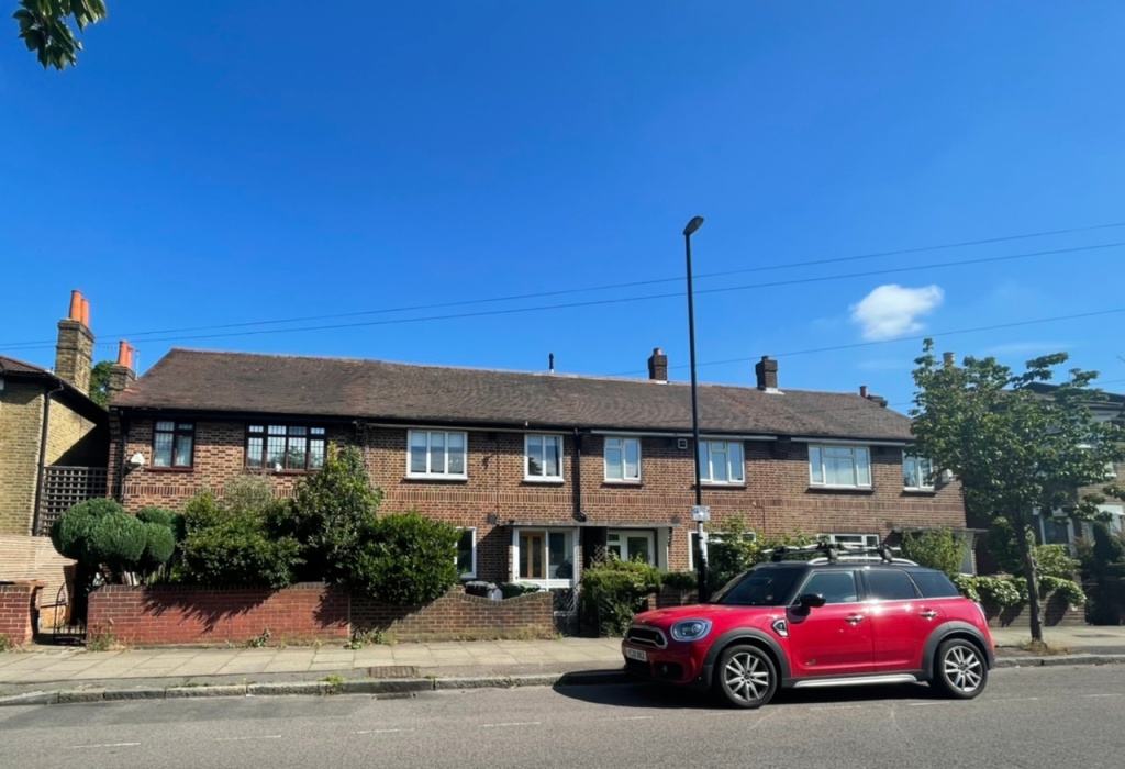
At 82 there were two deaths – one was the 23-year-old Monica Tew, who was listed as the daughter of H Tew. It may be remembered that Monica’s sister, Doreen was living there in 1939, the Tews may be have been displaced by earlier raids elsewhere.

82 was a shared house by 1940, also there were the Setons whose 7-year-old daughter Elizabeth also perished.  She had probably been originally been evacuated (see above) but had later returned to Lewisham.

Assuming that Florence Brosinovich had remained at 80 in the year since the 1939 Register was collected, she would have been made homeless – it seems that she moved to somewhere in the Reigate, Godstone, Dorking and Epsom area of Surrey where she died before the war was out in 1943.

There were other bombings on the street – lots of incendiary bombs fell around the junction with Wantage Road on 8 December 1940, not obviously causing any significant damage.  At some stage houses closer to the now Sainsburys site were destroyed, although this was either missed when I went through the ARP logs or wasn’t recorded, not every incident was on busy nights. 

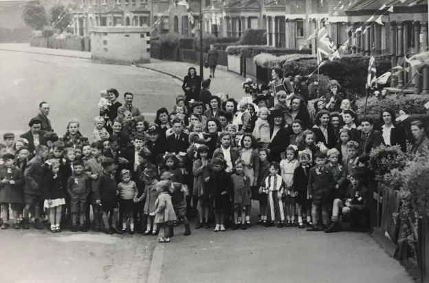
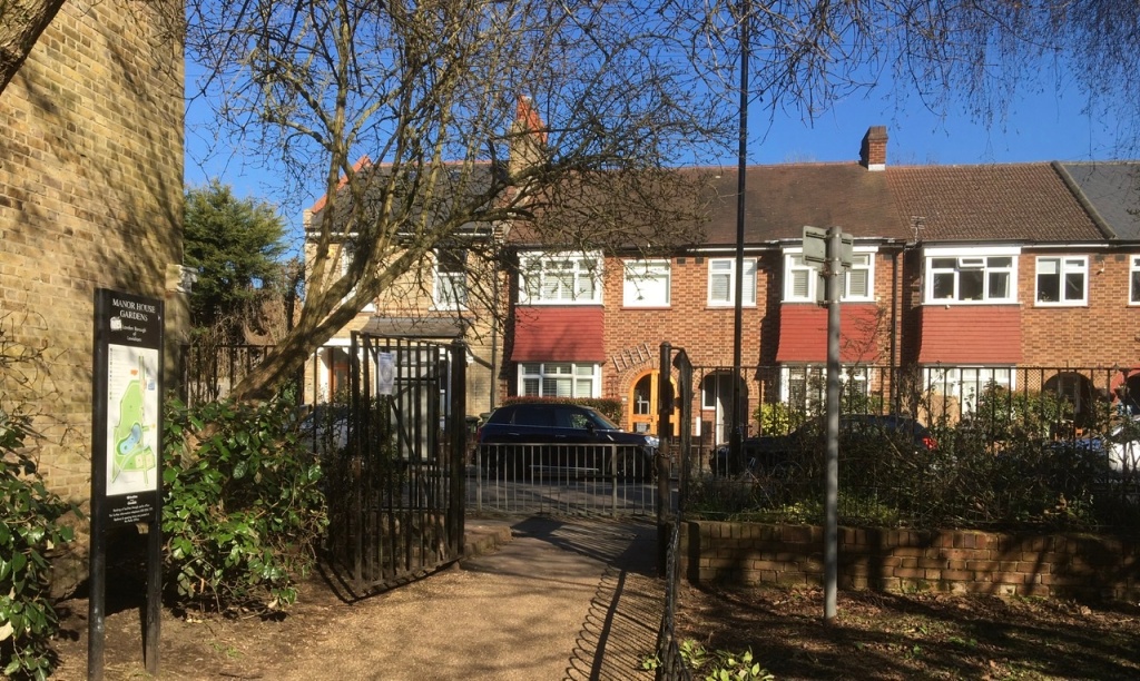
At the end of the War, on VE Day there were celebrations of the end of the war, no doubt they were tempered by the deaths and injuries to friends and neighbours.  There was certainly a party on Taunton Road, possibly two.  The photograph above is taken from around the park entrance looking back towards Wantage Road – there is a concrete air raid shelter in the background.  The one below is in the section close to Burnt Ash Road that was redeveloped 20 years or so later. 

Notes & Credits

  • The photograph of Spoilbank Cemetery is via Wikipedia on a Creative Commons
  • Thank you to David Carter for the information about his family who were orphaned in September 1940 link here
  • The photographs of VE parties are from the collection of Lewisham Archives, they are used with permission but remain their copyright
  • The photograph of Hedgely Street School is from a booklet produced by Church of the Good Shepherd, Lee in 1956, p15 – it remains their copyright and was accessed via Lewisham Archives and was used with the permission of both
  • The census and related data comes via Find My Past (subscription required)
  • The World War One casualties come from the Commonwealth War Graves Commission website
  • Most of the detail of the bombing raids come via the ARP Log for Lewisham which is held by Lewisham Archives
  • Thank you to Denise Whibley Baba on Facebook for details of Alfred Edward (Edwin) Braine.

Brightfield Road – the Street with Two Names, Part 2

In the first part of this post, we explored the 19th century history of Brightfield Road from its building as Robertson Street to its extension and renaming in the 1880s. We turn now to the 20th century and beyond, looking in particular at how the street fared in the World Wars.

We pick up the story with the 1901 census; the street had changed in the late Victorian period from homes for the building trades employed by John Pound, and other local builders, as well as for servants for the large houses in Lee, to a wider mixture of working class occupations.  Looking at the lower numbers at the eastern end of the street, little had changed by 1901 with a mixture of working class jobs such as road mender, carpenter, horse keeper and coachman (this excludes the shops which we will return to in a later post).

The average size of households had reduced to 5.3 (from 5.8 a decade before) mainly as a result of slightly fewer households taking in lodgers and/or houses being split between households. This was much smaller than the numbers in the not dissimilar homes in Ardmere Road in Hither Green which were built at around the same time.

There was little change by 1911, although the average household size dropped again to 4.5.  The nature of the jobs was little different though – manual trades and still lots relating to horse based transport.

The street fared badly in World War One, many of the sons, brothers and husbands of the households were either volunteers or conscripts to fight on the battlefields of France and Belgium – eight of them never returned home to Lee all were buried in cemeteries or remembered on memorials close to where they died.

  • William Upton of number 42 was a Driver in the Royal Engineers and died on 13 March 1918. He was a labourer in civvy street and was around 25 when he died; he was buried at Sailly-Labourse Cemetery in France.
  • Sidney George Munday lived five doors up from William Upton at 52, he was a Private with The Buffs (East Kent Regiment). He was 21 when he died on 14 April 1918 and is remembered at the Tyne Cot Memorial in Belgium.
  • William Henry Church had lived just over the road at 33, he was just 20 when he died serving as a Private in the Queen’s Own (Royal West Kent Regiment) on 18 September 1916.  He was buried at Etaples Military Cemetery in northern France.
  • Willie J Church was just 18 when he died on 6 June 1918, serving as a  Private in the London Regiment.  He is buried at Bienvillers Military Cemetery in France.  He lived at number 85, it isn’t clear whether he was related to William Henry Church.
  • Arthur John Cobb will have known Willie, as he lived  two doors away at 89 with his wife Gertie.  They served in the same Regiment too.  Arthur died on 18 February 1917 and was buried in France at  Merville Communal Cemetery Extension.
  • Alfred William Meggs lived seven doors down at 75, he was 20 and serving as a Corporal with the Queen’s Own (Royal West Kent Regiment) when he died on 3 October 1916.  He is remembered at the Thiepval Memorial, pictured above.
  • William George Bickle had lived five doors away at 65, he died two days after Christmas in 1915 aged just 16, the youngest on the street to perish. He shouldn’t have been there but, probably like Willie Church he will have lied about his age – soldiers needed to be 18 to sign up and 19 to be sent abroad as we saw with Herbert Burden from Catford who was shot for desertion aged just 17.

As World War Two broke out, the numbers living in the smaller houses at the eastern end of Brightfield Road were probably the lowest that there had ever been in the street’s existence – an average of just 2.9 people per home.  A large chunk of this related to the evacuation of children in September 1939, just before the ‘census’ for rationing purposes was taken, the 1939 Register.  However, even taking this into account household size had reduced with very few lodgers and a lot more houses just inhabited by couples and single people.  This will probably be at least in part as a result of limited non-contributory pensions being paid from 1909.

Since 1911 all the horse related trades had disappeared and the eastern end of the street was home to several involved in train, lorry and tram related transport.  There were several working at the Royal Arsenal making armaments.  Very few had the ‘Heavy Work’ suffix to their role which would have allowed them to have larger rations though.  The difference with Ardmere Road here is significant.   A slightly smaller proportion of women worked to 28 years before in 1911, but the trades were little more diverse – still mainly shop, laundry and work and dressmaking though.

There were a couple of nights heavy bombing in early December 1940, on the nights of the 8th and 9th of December.  Given the significance of these nights in the area we’ll return at some point but several houses had incendiary bombs hit them – 19, 20, 22, 43, 46, 52, 60, 113 and 123.  All seemed to have been put out and the houses remain.   There was a high explosive bomb that seems to have landed in the rear garden of 95 without causing too much damage.

Just after Christmas incendiary bombs rained down on Brightfield Road with 32, 34, 42, 43, 49, 63 and 83 all hit by them (some are pictured below) – the fires were put out by wardens and the inhabitants, but many of the roofs were damaged.

Early in 1941 there was a high explosive bomb that hit the roadway close to the bridge over the Quaggy, several houses were destroyed or had to be demolished due to the resulting major gas explosion (1). The damage is the darker colours is shown on the bottom left hand corner of the map below (2). No one died with only two requiring optional treatment but there was widespread damage in terms of broken windows and major structural damage to houses up to 100 metres away (3).

On the odd side, 103 – 107 were never replaced and the gap was used to form an entrance to Manor House Gardens.  Over the road, whilst the last house, 92 (at the left of the photograph) survived, 84 to 90 didn’t and they were replaced by private sector housing after the war.

Over the bridge, 75 to 79 were lost too at some stage in the Blitz.  They too weren’t replaced – the playground to what was then Hedgley Street School (now Holy Trinity School) was extended.

Several civilians on the street died;

  • Annie Taylor from 121 Brightfield  died in an attack on 110 Springbank Road as we saw in a post on that street;
  • Alfred Dibley of 56 died on 5 July 1944 at St John’s Hospital on Morden Hill presumably as a result of a V-1 attack;
  • Elizabeth Grant of 70 died at Albion Way Shelter early in the Blitz and
  • Eliza Jenner was injured at an attack on number 4 on 11 May 1941 and died at Lewisham Hospital the same day.  

There was a VE Day party there, a bit later than most on 2 June 1945.  The street scene is now markedly different – the attractive bank buildings (once a temperance coffee house) and the three storey shops at the end of the street were lost after the war either to Penfold’s or Sainsbury’s expansion.  We’ll return to the shops in a later post.

So who lives there now?  While it isn’t possible to use census data from 2011 just for the street there is a Output Area that relates to most of the street, along with Lampmead Road.  The employment categories are very different to the census data that we have looked at before.  The main employment types of the 196 residents in employment were shops (7%), finance, insurance and banking (10%), professional and scientific (13%), education (19%) and health (7%).  It will be interesting to see what changes there are when the 2021 Census results are collated.

Most of the homes seem to be owner occupied homes – although there are eight or nine owned by property companies letting the homes and three are let by social landlords.  The change is massive compared with when the homes were built as Robertson Street when virtually all will have been privately rented.

Certainly rising house prices will make affordability nigh on impossible for the sort of people that lived there before World War Two. One of the bigger houses was sold for £842,500 in 2020 – now single-family dwellings, when built they had been ‘conveniently arranged for two families. Let to very respectable tenants at 12/- a week’ in 1892 (4). 

One of the smaller houses sold for just under £500,000 just before the first lockdown.

We will return to Brightfield Road at some point in the future to look at the shops that used to be on the street.

Notes

  1. Phyllis Willmott (1988) Coming of Age in Wartime London, Peter Owen p51
  2. Laurence Ward (2015) The London County Council Bomb Damage Maps 1939-1945 p116
  3. Willmott op cit p51
  4. Kentish Mercury 25 July 1892

Credits

  • Permission has been given by the copyright owners of the Bomb Damage Maps, the London Metropolitan Archives to use the image here, it reamins their copyright
  • All the census and related data came via Find My Past (subscription required)
  • The photographs of the VE Day party is part of the collection of the Lewisham Archives, it is used with their permission and remains their copyright;
  • The photograph of the Theipval Memorial is on a creative commons via Wikipedia

The World War Two Home Front – Digging For Victory, Allotments and Women’s Land Army

Since the 80th anniversary of the outbreak of the Second World War in September 2019, Running Past has been looking at a number of aspects of life on the ‘Home Front’ during the War.  This has included the evacuation of Lewisham’s children to safer areas, the shelters built to try to keep the local population safe during air raids, the role of the Air Raid Precautions (ARP) Service and the rationing of food.  On a similar vein we’ll look now at what is referred to a Digging for Victory, the growing of food in gardens and allotments along with briefly looking at the Women’s Land Army.

In 1939 Britain was importing large quantities of food – including 70% of cheese, cereals and sugar, 80% of fruit and more than 50% of meat. It was fully expected that the Germans would target food supplies coming in via sea, as they had done with the U-Boat Campaign in World War 1.  At the national level merchant shipping was put under Admiralty control in August 1939 – with food coming via convoy.

While they have links back to the 17th century, allotments, as we know them, have their roots in the Victorian period, demand for them in areas such as the then suburban Lewisham seems to have come from middle classes who wanted space to grow their own.  As we have seen with Lee Working Men’s Institution and Lee Public Halls there were several gardening clubs locally. Allotment numbers were not that large though with 244,268 plots in 1873 across the   country.

Numbers grew steadily in the Edwardian era and by the time World War One broke out, there were somewhere between 450,000 and 600,000 allotments. Those pictured above, bounded by Hafton, Hazelbank and Wellmeadow Roads, probably date from early in this period.  There was a large expansion during World War 1 with just over 1.5 million allotments in England by 1918.

Numbers of plots declined in the interwar period such that by the outbreak of World War Two just 819,000 allotment plots were cultivated. Many around Lee and Hither Green were lost to development in this period – two of the larger interwar private housing developments in the area – the Woodstock (the area around Woodyates Road) and Verdant Lane estates were both built on allotment sites in the 1930s, as was part of Reigate Road on the Downham Estate and a plot to the north east of bend in Meadowcourt Road near Lee Green.

The Ministry of Agriculture launched the ‘Dig for Victory’ campaign soon after the outbreak of war in 1939. There was propaganda throughout the war encouraging people to use their gardens, parks and unused land for cultivation, stressing that ‘food just as important a weapon of war as guns’– several hundred thousand leaflets were distributed, with posters such as the one above displayed and it was a regular feature in propaganda films such as this one…

Around a million new allotments were created and many parks and open spaces were converted into allotments.  In the old Borough of Lewisham about 3000 were created (1)  – this included large swathes of Mountsfield Park as the 1940s Ordnance Survey map shows.

Parts of Beckenham Place Park were turned over to the growing of potatoes, with sheep grazing on the now former fairways (2).  Parts of Ladywell Fields were turned into allotments and on Blackheath around half of the triangular green bounded by Hare and Billet Road, Orchard Road and Eliot Place was turned into allotments.

One of the most iconic views in south London changed during the war with the field below the Observatory in Greenwich Park being dug up for allotments, the same had happened during World War One there.

It wasn’t just parks that saw food grown, other bits of land were brought into use too – a narrow strip of, presumably, railway company owned land between Milborough Crescent and the embankment was cultivated.  This was the same with the land on the other side of St Mildred’s Road where a narrow strip all the way down to Grove Park Nature Reserve was turned into allotments.

Other land too seems to have been taken over –  the land in a triangle bounded by Dacre Park (then Turner Road), Boone’s Road and Lee Park was a nursery and had been since the 1860s, probably before, emerged out of the war as allotments.  They continue to remain in that usage and are pictured below.

Another aspect of maintaining food availability was increasing the amount of help on farms – this was done through the Women’s Land Army which was launched ahead of the War in June 1939.   This was initially based on volunteering but a degree of conscription was added. By 1944 it had over 80,000 members; while most were already rural based around a third came from London and other cities.

Several women from Bellingham, including Olive Boyes who had previously worked at Chiltonian Biscuit Factory, Rene Powell and Joan Hicks joined the Women’s Land Army in the spring of 1942. They took a train from Catford to Ashford with Olive and Rene ending up in a small village called Hamstreet, with Joan and her friend Ivy being sent to Faversham.

Betty Hilda Baker lived at 41 Nightingale Grove had started the war as a ‘confectionary hand’ – perhaps working for Whitehouse and Co. at 36 Old Road.  Born in 1918 she was living with her parents, Charles and Julia, along with what are probably two younger siblings, Stanley who was a 23 year old butcher’s assistant and one that was redacted. It is known that she joined the Land Army but not known where she was stationed.

Joan Pearson lived at 73 Bramdean Crescent in Lee, at the outbreak of war she was an invoice clerk for Fords, aged 17.  When she joined up in 1942, she was working for Crosse and Blackwell near Charing Cross station – she wanted to ‘do something useful’ and to ‘get away from London.’ She ended up driving tractors in the New Forest.

Notes

  1. Lewis Blake (1995) How We Went To War – Deptford & Lewisham 1939 -1945 p24
  2. ibid

Where not specifically referenced, examples of locations of allotments come via Ordnance Survey maps.

Credits


Woodlands Street – A Hither Green Street

Woodlands Street is a Hither Green road that has been touched on a couple of times before – notably in relation to its builders, WJ Scudamore who completed work on this and the neighbouring streets of Benin and Blashford at the end of the 19th century.  This post looks at what was there before the the street was developed, Hope Cottage, the early residents along with the impact of the war on the street along with recent changes.

Hope Cottage was built on farmland in around 1840; it was described initially as Wood Cottage in the 1841 census. While it was called a ‘cottage’ it was anything but and was located on what is now the forecourt of the shops of 272/274 Hither Green Lane (1). Unlike many of the large houses in Hither Green and Lee, there was no complicated history of ownership and tenants to unravel, Hope Cottage was built for, and inhabited by, the same family throughout its life. The Ordnance Survey cartographers got to name wrong when they surveyed the area in the mid-1860s – describeing it as Oak Cottage.  The real Oak Cottage was further south off what is now Verdant Lane.

It was built for William and Eleanor Butler (both born around 1785), the former was a wealthy grocer and property owner who hailed from St Pancras. It was an area they seem to have stayed in as all the children were born there.

In the 1861 census, what was then referred to as Hope Cottage was described as being in ‘Brightside’ – a lane down the side of the property to a property of that name, it is a name which lives on in the relatively nearby Brightside Road.  Hope Cottage was home to the now retired Butlers, William and Eleanor along with their adult children Charles (42, born in 1819) and William (56, 1805) who were both fund holders and Eleanor (45, 1816) who didn’t work.

Eleanor (Snr) probably died in 1870; but everyone else had remained at Hope Cottage, with Richard, born in 1819 having moved back to the house. William (Snr) died in 1876.  By 1881, all the younger Butlers were still there and had been joined by their younger sister Elizabeth who was widowed, all were described as having an income derived from houses and dividends.

By 1891 there was just Charles, Eleanor and Elizabeth remaining, all described as ‘living on their own means.’  In the latter years of the three siblings, the city was rapidly encroaching on what had been originally a country house:

By this stage Charles was the only remaining Butler, Elizabeth had died in 1893 and Eleanor in 1896. Charles sold up to W J Scudamore soon after Eleanor’s death and seems to have moved in with a nephew in one of the large houses on Brownhill Road – he was there in the 1901 census.

This was one of the earlier sites in the area that family building firm W J Scudamore developed in the area; the work was started in the late 1890s with payments for the connection of the sewers into Hither Green Lane made in 1899. However, the building was probably over several years. In the 1901 Census,  21 – 27 at the south western end (away from Hither Green Lane) were not recorded, with 19 and 20 (the numbering is consecutive) appeared not to be fully occupied and may have only just been let.

Unlike some of the bigger houses on Hither Green Lane along with the bigger Corbett Estate houses, Woodlands Street was a working class street.  Virtually all the houses were subdivided into flats, 3 room flats 6/- (30p) a week with the 4 room variants 7/6d (38p) in 1904 (2) with the homes managed from the Scudamore’s estate office at 1 Benin Street.   It was only the southern side of the street that was built on – the edge of the Park Fever Hospital formed the northern side of the street.

A few houses seemed have singles families, including the Ives at 2 and the Lees at 6, although with each of these it may be that part of the house was empty at the time the enumerators called in 1901.  Some were significantly overcrowded – there were 14 people living at number 4.  That said there were slightly fewer people living there on average than in the smaller houses in Ardmere Road in 1901 – the average there was 7.4 per house, with 6.9 in Woodlands Street with a median (mid-point) of 8 and 7 respectively.

The trades were all manual work, a lot linked to the building industry – it will be remembered that the Corbett Estate was still being built and while the Archibald Cameron Corbett used some of the smaller houses in streets such as Sandhurst Road to house workers, the demand for housing will have spilled out into estates such as this.  Some of the tenants may also have been employees of the Scudamores. There were several bricklayers, a pair of plumbers, a house painter and a trio of carpenters.  Several worked on the railway, perhaps based at Hither Green.

In the early years there were a few cases of crime – several of these involved neighbour disputes and included one of tenants of 24 being convicted for throwing a flower pot at child of the other tenant of 24, while it missed, the court fined her 5/- (25p) (3).

There were a fair number of cases of drunkenness; George Fowler of 10 was convicted of being drunk and disorderly, using abusive language towards the police and fined £1 or 2 weeks in prison (4). His neighbour at 11, Andrew Smith,  was arrested for being drunk and disorderly at the Black Horse in Catford in 1905 and was fined as a result (5).

Richard Sancto of no 7 was charged with being drunk and disorderly and assaulting Joesph Gibbs of Ardmere Road and a police Constable who tried to break up a fight in Courthill Road. Sancto was sentenced to two months hard labour in the summer of 1907 (6).

There were thefts too, some local, some a little further afield – Fanny Gotts of 13 was charged with the theft of two pairs of trousers in Greenwich – pleaded guilty and sentenced to 21 days hard labour (7).

By the time the 1939 Register was collected just after the outbreak of World War Two, the nature of employment on the street had changed markedly.  As was the case in Ardmere Road, the number employed in the building industry had dropped sharply – this was not surprising as, other than a few small infill sites, there wasn’t much new housing being built in the area.  Work was almost entirely manual amongst the men, with around 1/3 being given the ‘heavy work’ suffix which attracted additional rations during the war.  There were lots of labourers, a few lorry drivers, and several working on the railways.  Other than those who were unmarried, very few women worked – amongst those who weren’t married there were several cleaners, a couple of telephonists, a typist, a tie packer and a knitting machinist.

In the 28 houses (48 households) six were working on war preparations with the navy in Deptford, RAF Kidbrooke and the Royal Arsenal.  In addition three of the residents on the street had already been recruited to Air Raid Precaution work – Albert Chambers at 15 and Albert Hudson at 18 were part time ARP Wardens with Frederick Cook at No 2 recruited on a full-time basis.

There were more children in the street than perhaps expected – eleven with ages and another 22 redacted cases (anyone who may still be alive is blacked out on the Register).  Most children had been evacuated, including from the school site that many of the boys will have received their education at Catford Central Boys School, Brownhill Road Boys School which was split into infants and juniors.

One other point that has already been alluded too was that these were still shared houses.  The levels of overcrowding were not as great as in 1901, although this is probably largely explained by evacuation.

Key: black=total destruction, purple=damaged beyond repair, dark red=seriously damaged (doubt if repairable), light red=seriously damaged (repairable at cost), orange=general blast damage (non-structural), yellow=blast damage (minor), green=clearance area

There was some damage to the street as a result of World War 2 attacks – Woodlands Street is around the centre of the map above; it is coloured red which means that the homes were ‘seriously damaged (repairable at cost)’ – given that the Park Hospital next door was a one of the two specific targets of the Luftwaffe, along with the railway marshalling yards behind Springbank Road (8), it is perhaps surprising that there wasn’t more collateral damage during the Blitz.

In fact, the main damage came in an awful day time raid on 20 January 1943 when a number of FW190 planes got through defences with indiscriminate shooting  at numerous civilians, killing 6 people and injuring 14 others.  Each plane had a 500 kg bombs; one of these was dropped at Sandhurst Road School at 12:31 killing 38 children and 6 teachers.  Another landed in Woodlands Street 4 minutes later– the impact must have been in the street itself as none of the houses were destroyed, and just 2 injured.  The ARP Log notes that the road was closed due the scale of debris and that 66 houses were severely damaged – this included houses in neighbouring streets too.

In some locations where World War 2 damage is easy to spot with replacement houses in a different style or large areas of different bricks used – there were brick shortages post World War Two and it was often to get exact matches. The tell-tale signs are less clear here – in a few houses bricks the red brick detail around square bays of the yellow London Brick Co ‘Stocks’ is missing.  But the only really obvious signs are on one house above with different window styles and a missing pointed roof to a bay window.  That said, a lot of houses on the street are  rendered or have painted brickwork which hides what happened underneath.

The street outlasted the hospital next door which closed in 1997.  The hospital site was redeveloped over the next decade or so mainly by Bellway – ‘badged’ as Meridian South (the Prime Meridian passes through the end of Woodlands Street).  The Woodlands Street part seems to have been one of the later phases and was developed for a housing association.

Notes

  1. Godfrey Smith (1997) Hither Green, The Forgotten Hamlet p35
  2. Kentish Mercury 05 February 1904
  3. Woolwich Gazette 15 July 1904
  4. Kentish Independent 11 September 1903
  5. Kentish Mercury 06 October 1905
  6. Kentish Mercury 09 August 1907
  7. Kentish Independent 13 March 1903
  8. Smith op cit p63

Credits

  • The Ordnance Survey map is on a Creative Commons from the National Library of Scotland.
  • Census, 1939 Register and related data is via Find My Past (subscription required)
  • The ARP Log was accessed via the under-resourced, but always helpful, Lewisham Archives
  • The bomb damage mape is via Laurence Ward’s ‘The London County Council Bomb Damage Maps 1939-1945’ published in 2015 – permission has been given by the copyright owners of the map, the London Metropolitan Archives, to use the image here

World War Two Food Rationing in Lewisham

Since the 80th anniversary of the outbreak of the Second World War in September 2019, Running Past has covered a number of aspects of life on the ‘Home Front’ including the evacuation of Lewisham’s children to safer areas, the shelters built to try to keep the local population safe during air raids and the role of the Air Raid Precautions  (ARP) Service.

We turn now to food rationing which was introduced on 8 January 1940; we’ll cover cover the linked issue of growing food in allotments and gardens through ‘Digging for Victory’ in a later post. Rationing didn’t completely end until 1954 and also covered clothes, petrol and various other goods.

In 1939 Britain was importing large quantities of food – including 70% of cheese, cereals and sugar, 80% of fruit and more than 50% of meat. It was fully expected that the Germans would target food supplies coming in via sea, as they had done with the U-Boat Campaign in World War 1.

The preparations for food rationing had begun soon after war started with the compilation of the 1939 Register which was used to was used to devise a carefully detailed rationing plan and issue Identity Cards. It listed everyone living at properties, although in London there were very few children mentioned due to evacuation that had happened a few weeks earlier; it also excluded any serving locally based adults serving with the armed forces.

Running Past has used the 1939 Register several times to look at specific streets, including Ardmere Road (pictured above), close to Hither Green Station. So, at 1 Ardmere Road, there was Fanny and Frederick Histed, the latter was entitled to extra rations due to his ‘Heavy Work’ as a builders labourer. Next door at No 2 (the numbering is consecutive) Amy and John Ashling lived, John was a general labourer, but not entitled to extra rations. It was the same at No 3 where Albert Tolhurst was also a general labourer. In the street as a whole just under a half of the men had the suffix or prefix to their trade of ‘Heavy Work’ which entitled them to extra rations. The differences were stark when we looked at both the Verdant Lane estate and the Arts and Crafts housing on Old Road – both had only a smattering of people entitled to extra rations for ‘Heavy Work.’

From 8 January 1940, every individual was issued with a ration book (see below, along with an Identity Card) which was registered at their local shops. Shopkeepers were then supplied with sufficient food for everyone registered. Ration books worked on a coupon based system, so people could purchase their entitlement but no more, although a good relationship with the shopkeeper might lead to more favourable treatment.

So in the terrace of shops 310 to 332 Lee High Road, locals may well have had ration coupons for the butchers RC Hamnett at 324; those close to Manor Park Parade (which will feature in posts in early 2020) would have no doubt queued up for their rations at Arthur Howard’s grocer’s shop at no. 16.

Returning the Ardmere Road, the locals from there and neighbouring streets such as Brightside Road would have taken their ration books to Edith May’s grocers at no 18 (which is pictured above), the shop closed in the 1980s and it is now a house. There are memories of the shop having (in this period and beyond)

Old marble counters, wooden single drawer for a till, flagstone floor, shelves with doilies and a huge brass scales.

So what were the foods that Lewisham residents would have found rationed during World War 2? Initially, it was just bacon, butter and sugar were rationed; but meat was rationed from 11 March 1940; cooking fats and tea in July 1940; while cheese and jam were added to the list in March and May 1941.

The amounts of each item varied a little over time

  • Bacon and ham 113 – 227 g (4 – 8 oz)
  • Sugar 227 – 454 g (8 – 16 oz)
  • Tea 57 – 113 g (2 – 4 oz)
  • Meat 5 – 6p worth (1/- to 1/2d)
  • Cheese 28 – 227 g (1 – 8 oz)
  • Preserves 227 g – 1.36 kg (8 oz – 3 lb)
  • Butter 57 – 227 g (2 – 8 oz)
  • Margarine 113 – 340 g (4 – 12 oz)
  • Lard 57-85 g (2-3 oz)
  • Sweets 227-454 g (8-16 oz) – monthly

Lewisham Market survived during the early part of the war, although fruit such as oranges and bananas which were relatively common before the War became something of a rarity with queues ‘a mile long’ when they became available (1). Tomatoes too were much less common on the market than they had been pre-war; when they were available, traders typically imposed rations of their own, limiting purchases to 8 ounces (227 grams) (2). As a result there were long queues with children often sent to take adult places in the queue, while parents got on with the rest of their shopping (3).

However, it really struggled after V-1 attacks (4) including a direct hit on the market itself in July 1944.

There is a fascinating film in the collection of the Imperial War Museum, which was aimed at American audiences which is at least partially Catford based – the Catford Bridge Tavern is clearly visible in one of the shots. Unlike many of the other propaganda films, including ‘Britain Can Take It’ this wasn’t one made at Blackheath’s GPO Film Unit, made by the smaller World Wide Pictures.

Some with longer memories than mine recognise the shop that ‘Mrs Green’ is coming out of as being Sainsburys at 58 Rushey Green (pictured below, probably just after the War), almost next door to the current Aldi Shop.


Credits


Notes

  1. Lewis Blake (1995) How We Went to War – Deptford & Lewisham 1939 – 1945, The People’s Story p23
  2. ibid p24
  3. ibid p23
  4. ibid p23

The Bombing of Sandhurst Road School

Perhaps the most depressing and bleak of Lewisham’s World War Two memorials can be found in Hither Green Cemetery on Verdant Lane – it is to the 38 children and 6 teachers who perished in a daytime bombing of Sandhurst Road School on 20 January 1943.

The school between Minard and Ardgowan Roads had been opened in 1904 – midway through the development of the Corbett Estate – it was not that dissimilar to many of the era, including the one on Eltham’s equivalent Corbett Estate.  The opening ceremony was performed by the Chairman of the London County Council (LCC), J Williams Benn – grandfather of the late Labour politician Tony Benn. The LCC had just taken over responsibility for London’s Schools including those in Lewisham, from the London School Board.

Many children had been evacuated from London in September 1939 but as bombing became less frequent after the Blitz ended in May 1941, lots had returned to the capital.  It was to be another 18 months before V-1 flying bombs started hitting south London.  There were though a few sporadic attacks designed to terrorise the civilian population in the intervening period – often in retaliation for Allied bombing raids on German cities – these became more organised towards the end of 1943 with Operation Steinbock.

The facts as to what happened are quite simple; it was lunchtime at Sandhurst Road School on 20 January 1943.  A group of 28 Focke-Wulf 190 Fighter-Bombers, escorted by Messerschmitt Bf 109 fighters (totalling about 60 planes), had taken off at around noon in occupied northern France and had evaded air defences and one of them was able to fly low over Catford and Downham. One of the  Focke-Wulfs was seen over Downham Way spraying bullets towards those on the ground; soon after it flew over Ardogowan Road, just above the roofs of the Corbett Estate, it was carrying a single 500 kg bomb.

At just before 12:30 the plane flew over Sandhurst Road School, there were reports that the plane looped around the school with the pilot waving to children in the playground.  On the ground, the bell for lunch had just gone – a few children heard a distant air raid warning siren.  Some pupils made their way to the air raid shelter – oddly a bricked up classroom on the second floor.  The sound of the plane was heard and a few outside realised that it had black crosses of the Luftwaffe.

The bomb was dropped and the children in the air raid shelter were

transformed from neatly dressed school girls into ghastly frightening creatures, covered all over in dust which was choking us too and some of us bleeding from cuts …somehow, there was no panic — just bewilderment. Choking, bleeding and with tears streaming down our faces, we made our way out of the shelter, over girders, plaster, bricks, wood, glass ….. through the debris … there was a huge smouldering gap below us were the bodies of those children (who had been queuing up for lunch), some dead, some dying, some in terrible pain.

Initially even some of the children started to try to help with the rescue effort before emergency services arrived on the scene, but by the evening

it seemed that every available man in the locality was there, digging, some with their bare hands, as was my brother, frantically searching for loved ones, hearts and hands torn. Boys in the services home on leave, digging, searching, all through the night. The Red Cross, the women in the church hall just across the road making tea, tending those brought into the hut, even the vicar in his shirt sleeves had been there since the search had begun. All with one motive, even if it meant constant danger from falling rubble — to get those little mites out.

Sandhurst School1

© IWM. Original Source– Non-commercial reproduction allowed

Despite the claims of the pilot waving at children there is some debate as to whether the pilot realised that it was a school – his report on the raid noted that the large building destroyed was block of flats.  However, other local schools though seem to have been attacked by machine gun in the raid, not necessarily by the same plane though, including at the nearby Catford Boys School and at Prendergast (then on Rushey Green) and a little further away on Ilderton Road, off the Old Kent Road.

Sandhurst School 2

Source News Shopper

In addition to the attack on Sandhurst Road School and the indiscriminate machine-gunning of civilians, which killed six and injured fourteen, there were several other local bombings in the same raid – the recorded ones are serious damage to several houses in Woodlands Street, off Hither Green Lane; Woodham’s Yard on Sangley Road (covered in happier times in Running Past in 2017) took a direct hit with six perishing and 14 injured; and four houses were demolished in Glenfarg Road (1).

Most of the victims, 31 children and one of the teachers, Harriet Langdon, were buried together at Hither Green Cemetery in a civilian war dead plot a week later after a memorial service at St Andrew’s Church on Torridon Road.   The photograph with the small coffins at the crowded cemetery from the Illustrated London News, below (2), is perhaps the most poignant one relating to the bombing, much more so than those of the destruction to the school.

Equally moving was a description within one of the press reports from the Daily Herald (3) of one brief encounter with a 14 year old at the cemetery

“Children walked past the grave – snowdrops narcissi, anemones drifted over the silver name plates.

A girl twitched my coat.  She said “Can you see Rodney’s names down there?  I’ve brought violets for him. They’re the first from the garden.

She was June Jarrett.

When the school at Lewisham was hit, she spent hours searching in the debris for Rodney, her six-year-old brother.

Now with violets in her hand she sought him again.”

Unsurprisingly, most of the victims lived relatively close by, within a mile and a half or so of the school; there were still some who lived some distance away – their parents perhaps moving after the child had been admitted to the school. As has been noted in other posts on World War 2 bomb and rocket damage, despite the war there was still a lot of movement between homes in an area where the private rented sector was large and security of tenure limited, but obviously too because of damage to homes in the Blitz.  The biggest concentration was around  South Park Crescent where 5 of the victims lived.

The orange ‘pin’ marks the school, blue pins children, purple the homes of two siblings and red, the homes of the teachers who died (one is off map in Surrey).  The data came from the CWGC website.

There don’t seem to be any equivalent daytime attacks on Berlin schools by the RAF, although attacks tended to be at night time to avoid the German air defences.  There were in total just over 67,000 British civilian deaths during the war – a figure dwarfed by the numbers of ordinary Germans who died – estimates vary from 1.5 to 3 million, including thousands in the Charlottenburg area that Lewisham is now twinned with.  But it seems that this Terrorangriff, terror-raid, may have been a reprisal, demanded by Hitler, for a RAF bombing of Berlin on 17 January 1943.

That so many bombers got through the air defences without adequate warning and allowing such a catastrophic loss of young life to occur seems like an abject failure.  The Air Minister’s explanation was it was initially thought that the raid was heading for the south coast and it was policy not to send warnings to London unless it was certain that the raid was heading that way. Otherwise the Germans could have easily sent Londoners scurrying into shelters every few hours by sending planes over Kent.  It appears that of the 60 planes, it was a smaller group of around 12 that peeled off towards London which was initially missed and as a result warnings were late (4).

The school was rebuilt after the war and remains – there is a memorial garden of remembrance to the victims and a stained glass window.

There are several contemporary videos that include footage showing the devastation of the school, including this one.

There are some memories of a survivors of the attack in a documentary made to mark the anniversary of the start on World War 2.

The bombing is still remembered in the local community. One of the 2022 Corbett Estate Advent Calendar windows around 50 metres away from where the bomb hit, depicted it; it was day 20, the day of the month of the bombing with an angel for each of those who died. It is also included in series of tiles between reception and nursery at the school – see bottom picture.

Finally, it is worth remembering the names of those who died at the school

The children

  • Malcolm Britton Alexander (11)
  • Brenda Jean Allford (5)
  • Lorina Elizabeth Allford (7)
  • Olive Hilda Asbury (12)
  • Joan Elizabeth Baker (12)
  • Betty Ellen Barley (15)
  • Dennis Handford Barnard (10)
  • Ronald Edward Barnard (9)
  • Anne Rosemary Biddle (5)
  • Judith Maud Biddle (5)
  • Kathleen Myrtle Brazier (13)
  • Donald Victor Brewer (10)
  • Joyce Agnes Brocklebank (11)
  • Pauline Feo Carpenter (4)
  • Margaret Kathleen Grace Chivrall (12)
  • Pamela Mary Joyce Cooper (15)
  • Winifred Mary Cornell (13)
  • Eunice Joan Davies (9)
  • Pauline Mary Davies (7)
  • Joan Margaret Day (12)
  • Olive Annie Margaret Deavin (15)
  • Anthony Drummond (9)
  • Janet Mary Dutnall (5)
  • Richard George Fagan (9)
  • Cyril Arthur Glennon (6)
  • Norman Frederick Greenstreet (8)
  • Norah Marie Harrison (9)
  • Sylvia May Ellen Head (12)
  • Iris May Hobbs (15)
  • Rodney Charles Ash Jarrett (6)
  • John Edward Jones (10)
  • Doreen Alice Lay (6)
  • Mary Rosina O’rourke (15)
  • Evelyn Joyce Scholes (11)
  • Pamela Eileen Silmon (10)
  • Clive Derek Tennant (8)
  • Doreen Thorne (12)
  • Edna Towers (12)

And the teachers

  • Ethel Jessie Betts (53)
  • Virginia Mary Carr (38)
  • Mary Frances Jukes (38)
  • Gladys Maud Knowelden (51)
  • Harriet Irene Langdon (40)
  • Constance May Taylor (58)

Notes

  1. Godfrey Smith (1997) Hither Green – The Forgotten Hamlet pp63-64
  2. Illustrated London News (London, England), Saturday, February 06, 1943; pg. 159; Issue 5416
  3. Daily Herald 28 January 1943
  4. Hull Daily Mail 27 January 1943

The Lenham Road V-1 Attack

Lampmead and Lenham Roads are quiet residential streets coming off Lee High Road, they are mainly Victorian terraces.  There are also several infill homes built by the London Borough of Lewisham,or its forerunner.  There is a story behind their presence in the early 21st century streetscape – they are the indirect result of a V-1 rocket attacks which hit the junction of Lampmead and Lenham Roads on just before 5 am on the morning of 22 June 1944.

Running Past has covered several of the almost two hundred V-1 and V-2 rocket attacks on Lewisham, including the ones on Lewisham High Street, Lewisham Hill and Hither Green’s Fernbrook Road.  They are important to remember both in terms of the death and injuries caused to ordinary Londoners whose stories often get forgotten, but also in terms of their impact on the urban landscape – both in the short-term and longer term.

Six died as a result of the attack on Lenham and Lampmead Roads and no doubt many more were injured.  Those who lost their lives were James Joseph Carroll (20) and Patrick Leonard (26) who died at 34 Lenham Road; Hugh William George Harvey (59) who died at 6 Lampmead, Joseph Daniel Barry (55) died next door at number 8, his neighbour Alfred William Roedear (64) died at no 10 – his wife Annie appears to have survived, and Flora Borthwick (37) perished at 12 Lampmead.

What is perhaps surprising is that of those who died only one, Hugh Harvey, who was a groundsman and coach at the outbreak of the war living at 6 Lampmead Road, had lived there when the war broke out (1).  It is worth remembering that the private rented sector was still dominant at that time – accounting for almost 60% of homes – security of tenure, while perhaps slightly greater than it is now, was still limited.  In Lewisham these landlords included some of the bigger builders in the area – WJ Scudamore and James Watt.

During World War 1 there had been profiteering by some residential landlords which had led to rent strikes and unrest which threatened to undermine the war effort.  These had been repeated in the East End of London in 1938 and 1939. In this context, full rent control was introduced early in World War 2.  However, this seems not to have led to a stable community in this part of Lee – similar issues were found with the Lewisham Hill V-1.

The V-1 would have exploded on impact and a blast wave rippled out from the impact point, effectively creating a vacuum in the centre – the combined impact was to both push and pull buildings leading to large numbers of collapses.  The impact was often spread over quite a wide area with total destruction in the centre with much less damage on the outside.  The map below  produced by the London County Council during the war (2) shows this well – the darker the hand-colouring, the greater the damage.

Key: black=total destruction, purple=damaged beyond repair, dark red=seriously damaged (doubt if repairable), light red=seriously damaged (repairable at cost), orange=general blast damage (non-structural), yellow=blast damage (minor)

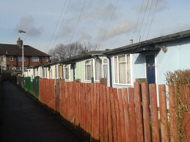
By the time the Ordnance Survey cartographers surveyed the area in 1949 (see below & note 3), the debris had been cleared and the site filled with 14 prefabs – a small part of attempting to deal with post-war housing needs.

The old Borough of Lewisham put up 1,610 prefabs by 1948 and a further 1,088 by 1955.  They would have no doubt not been that dissimilar to those on the Excalibur estate in Catford (below from 2014).  The prefabs probably lasted until the 1960s when they were replaced with council housing.

As the lower of the two maps above shows, there were several smaller gaps in the neighbouring Aislibie Road (named after Benjamin Aislabie – the last tenant of Lee Place), the result of bombing during the Blitz, the gaps were not used for the prefabs but they too were later filled by post war council housing.

Notes

  1. The 1939 Register didn’t cover armed forces so possible that some of victims had been living there before war broke out, employment details from Commonwealth War Graves Commission
  2. Laurence Ward (2015) The London County Council Bomb Damage Maps 1939-1945 – permission has been given by the copyright owners of the map, the London Metropolitan Archives to use the image here
  3. On a Creative Commons via the National Library of Scotland