Tag Archives: Lee Road

The 1878 Lewisham and Lee Floods

There were serious floods in Lewisham in September 1968 which Running Past covered on their 50th anniversary. Previous floodings of the Ravensbourne, Quaggy and Pool were mentioned in passing at that stage, including a reference to some very serious ones 90 years earlier in 1878. It is to these that we now turn our attention. In syndicated press reports it was reported that in Lewisham the ‘whole of the village (was) 3 or 4 feet deep in water’ (1).

The 19th century had seen several inundations of Lee and Lewisham –  Victorian historian FH Hart noted very serious floods in 1814 as the ice melted following one of the last big freezes of the Little Ice Age – the last time there was a frost fair on the Thames.  There had also been really bad ones in 1853 and another flooding following a period of heavy rain on Christmas Eve 1876 – but the 1878 ones were described as being ‘the worst in living memory’ (2). 

The spring of 1878 seems to have been a very dry warm one with surfaces left hardened.  From the early hours of Thursday 11 April 1868, 3¼ inches (83 mm) of rain fell in 12 hours while this was the highest for 64 years, it was substantially less that the rainfall that led to the 1968 floods.

Unlike the floods 90 years later in 1968, where the devastation was similar in the three catchments of the Ravensbourne, Pool and Quaggy; in 1878 it was mainly in the Quaggy and the Ravensbourne below the confluence with the Quaggy near Plough Bridge – named after the pub of the same name (pictured just before its demolition around 2007).

This is not to say the other parts of the catchment escaped – there was flooding higher up the Ravensbourne with Shortlands impassable; the local landowners at Southend, the Forster’s, home was flooded and the nearby bridge on Beckenham Lane (now Hill Road) was washed away – the bridge that replaced is pictured in the background of the postcard below. The cricket pitches by Catford stations were flooded up to sills of pavilion windows. Similarly, Bell Green was impassable on the River Pool (5).

The local press though focussed on the Quaggy and lower Ravensbourne – we’ll follow the trail of destruction and damage downstream from Lee Green. 

At Lee Green the basement of the shops at what was then called Eastbourne Terrace on Eltham Road (to the left of the photo, a couple of decades later) were completely flooded out with seemingly some flooding at ground level too. 

Further downstream where the Quaggy is bridged by Manor Lane, the road was impassable.  The area was in a period of transition from its rural past to suburbia, having been opened up by the railways through (but not stopping at) Hither Green, Lee and Blackheath.  There were still some larger houses from the exclusive village past – all situated in the higher ground around Old Road and on the hill between Lee High Road and Belmont Hill.   The lower lying fields were under water as was any housing built on the flood plain.  The same continued downstream through what is now Manor Park – the course of the Quaggy was a little different at that stage though. 

The houses that had been completed on what is now Leahurst Road (then a dog leg of Ennersdale Road) which backed onto the Quaggy were badly flooded.  As a result of the 1876 floods, the local Board of Works had built a large concrete wall, an early use of the material, to try to reduce the impact of future floods.  It was described as ‘perfectly useless’ as water bypassed it and inundated the houses in Eastdown Park.  The wall is still there – extended upwards a little after the 1878 floods.

There was a small dairy on Weardale Road, probably next door to the Rose of Lee.  Unsurprisingly it became flooded and the cowherd turned out the 30 cows who were found wandering in the water on Manor Park. The were taken to the higher ground of Lee Manor Farm.  Elsewhere in Lee, pigs were drowned.   

Beyond the Rose of Lee the relatively newly built Eastdown Park bridge ‘blown up by the force of the water.’ The bridge between Weardale Road and Eastdown Park also seems to have been destroyed.

The food waters became deeper as they went down Lee High Road, up to 1.2 metres (4’) deep in the houses of Elm Place, just before Clarendon Rise (then Road).  The Sultan on the other side Clarendon Rise was badly flooded too – the third time that this had happened in a decade as the publican, Robert Janes, explained in the press. The pub is pictured below from the next century.

Beyond the Sultan, flood waters flowed both over and under the road – at one point it was expected that the culvert  from the bottom of Belmont Hill to St Stephens church might be destroyed but in the end it was just the road surface that was wrecked – this is the high pavement that now stands in front of the police station. 

The roadway in front of St Stephens several feet underwater – with the Roebuck, Plough and other pubs such as the Albion all flooded.  Boats used to ferry people through Lewisham.  There was a real bottle neck around Plough Bridge, the ‘utter insufficiency’ of the narrow Plough Bridge to carry off ordinary storm water was regarded as one of the causes too. The whole area around Lewisham Bridge (pictured below from a few decades later) badly flooded, particularly Molesworth and Rennell Streets and unsurprisingly Esplanade Cottages in the middle of the Ravensbourne, along with the pub the Maid in Mill and rest of Mill Lane.

An iron girder bridge at Stonebridge Villas was washed down along with a wall by the railway, built to try to reduce flooding a year before was washed away – hundreds of houses on the lower lying parts of what became the Orchard estate to the east of the Ravensbourne were inundated. It was the same with the market gardens on the western side, along with large swathes of Deptford. Virtually all the area around the Ravensbourne on the map below from 15 years later was left underwater.

In addition to the high rainfall there was a clear underlying cause which was summed up well by a local man, Frederick Barff, who had grown up in Lee when it was still rural but was living in Eastdown Park in 1871 and if still there in 1878 would have been flooded out. He observed that prior to the development of Lee from the mid-1850s while there had been flooding, it initially stood in large areas of fields which absorbed the runoff without major consequences. The growth of Victorian suburbia had led to increased run off and more water ending up in rivers and stream and at a quicker pace (6).

In the immediate aftermath a temporary wooden bridge over the Quaggy between Weardale Road and Eastdown Park was approved the following day by the Metropolitan Board of Works (7).

There was a public meeting at the Plough on the Friday (next day) to ‘consider the best means of alleviating the distress amongst the poor of Lewisham, Lee, Blackheath and Catford. Crowded by the clergymen, parish officials and leading tradesmen of the district.’ In days before the state intervened in disasters like this it was left to charity to provide ‘coal and relief to those poor people in the district’ whose homes had been flooded. Over £200 was collected or promised for the Lewisham and Lee Inundation Relief Fund – with £120 going to the parishes of St Mark and St Stephen in central Lewisham that had been worst affected; £50 for Ladywell; with £50 for Lee and Blackheath.

So, what happened afterwards?  The approach that was used was one that continued towards the end of the 20th century and the 1968 floods – straightening and deepening rivers to try to move water on more rapidly.  This happened on the Quaggy behind what is now Brightfield Road – as the maps from 1863 and 1893 show. The Quaggy was also moved and straightened between Manor Park and Longhurst Roads – this happened a little later once the land was developed for housing.

Several bridges were replaced – the partially destroyed Eastdown Park bridge was rebuilt and replaced with a girder one (see below from the river), the river level is lower there now too, although whether this happened post 1878 or 1968 isn’t immediately clear (8). 

Plough Bridge was replaced in 1881 by the Metropolitan Board of Works (9) having been preceded by ‘general dredging and clearing the channels of the river’ (10).  Later a new sewer between Lee Bridge and Deptford Creek was constructed to try to take some pressure off the rivers from run off (11).

Another bridge replaced by the Board of Works was the one on Lee Road.  Previously this had been a ford and footbridge, but a large single span bridge replaced it following the floods, presumably with a lowering of the river bed (12). 

The underlying problems remained though, making flows quicker may alleviate problems in one location but without storage and a whole catchment solution, including the ability to control flows on the Thames it wasn’t much better than a sticker plaster. The fields that had acted as sponges continued to be developed and increased run off. In reality, not much had changed by the 1968 floods and it took the development of flood storage in Sutcliffe Park (pictured below) in the early 2000s to really make much difference. Without it Lewisham would regularly flood – it is pictured from late 2020.

Notes

Most of the information for this post comes from the Kentish Mercury of 27 April 1878 which covered the flooding and its aftermath in depth.  Readers can assume that contemporary information comes from there unless otherwise referenced.

  1. Dundee Courier 12 April 1878
  2. Kentish Mercury 20 April 1878
  3. ibid
  4. ibid
  5. ibid
  6. ibid
  7. Kentish Independent – 13 April 1878
  8. Woolwich Gazette 31 July 1880
  9. Woolwich Gazette 1 October 1881
  10. Kentish Mercury 16 October 1880
  11. Woolwich Gazette 17 June 1882
  12. Woolwich Gazette 31 July 1880

Credits

  • Census and related data comes via Find My Past, subscription required
  • The Ordnance Survey maps are on a non-commercial licence via the National Library of Scotland
  • Postcards of Lewisham Bridge and what was then Beckenham Lane are via eBay from 2016
  • The photograph of the Sultan is used with the permission of Robert Crawford, the great grandson of the Craddocks, licensees there in the 1920s, it remains his family’s copyright
  • The photograph of the destroyed bridge in Eastdown Park is from the collection of Lewisham Archives and remains their copyright, but is used with their permission

Beating the Bounds of Lee, Part 8 – Blackheath to Lee Green

We’d started our circuit of Lee at Lee Green during the first 2020 Coronavirus lockdown and the last leg from Blackheath to Lee Green was under the not dissimilar conditions of lockdown 2.0 in the late autumn of 2020. In the intervening months, Running Past followed the long thin boundary of Victorian Lee just before it was subsumed into Lewisham in 1900. The navigation was aided by an 1893 surveyed Ordnance Survey map.

This circuit has been in seven stages up to this point, from Lee Green to Winn Road, passing a street whose residents probably now wish it had a different name – Corona Road; the next stage was through Grove Park; then on through Marvels and Elmstead Woods; the circuit skirted Chinbrook Meadows and followed the appropriately named stream Border Ditch; then another Ditch, Hither Green Ditch, more or less parallel to Verdant Lane and Manor Lane before following the Quaggy from Longhurst Road into Lewisham, then in the penultimate part following a Quaggy tributary, Upper Kid Brook to Blackheath.

We’d left the boundary at a T junction of borders, Lee – Lewisham – Charlton with a replacement of a 1903 boundary marker of a similar style to those seen in several places around the border.

Source – eBay (Sept 2016)

The stone is next to the railway bridge and it is worth a quick turnaround by the first turning on the left, or would have been in 1893. A large Methodist chapel had been built in the mid-1860s and dominated the Blackheath Village skyline and was to do so for another 52 years until a V-2 rocket attack hit it in March 1945.

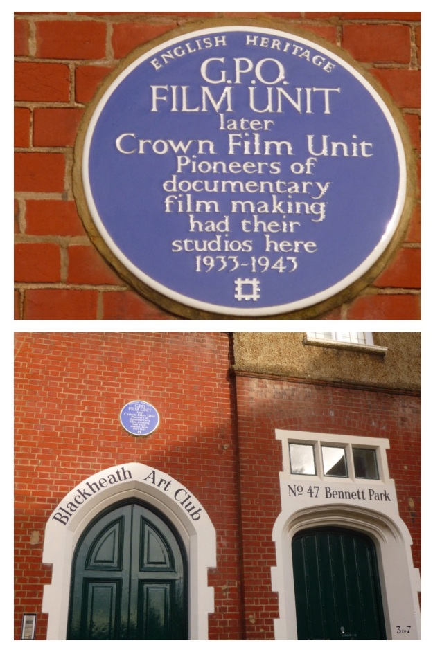
The turning is Bennett Park, which has one of biggest concentrations of blue plaques in south east London – the Physicist, Sir Arthur Eddington lived at number 4 – he was listed as a boarder there in the 1911 census, whilst working at the Royal Observatory. The cartoonist Donald McGill, lived at 5 Bennett Park – he was there when the 1939 Register was compiled. But, perhaps, the most significant is one at the far end for the GPO Film Unit, whose output included the wonderful film adaptation of W H Auden’s Night Mail, which featured a score by Benjamin Britten. The Film Unit also produced some World War Two propaganda films. The building had been partially funded by one the main benefactors of late Victorian Blackheath, William Webster, son of the eponymous main contractor of Joseph Bazlegette, as Blackheath Art Club.

Onwards and southwards, the boundary goes upwards and out of the valley of Upper Kid Brook towards the watershed with the adjacent Brook in the trio of Kid Brooks, Mid Kid Brook. Straddling the catchments is a pair of elegant buildings at the top of the hill – the Conservatoire of Music and Blackheath Concert Halls, again in part the paid for built by William Webster. Both were a few years away in 1893 though, there was a terrace of houses there at that stage. The Concert Halls, resplendent with some lovely pargeting, were to be the location of a badly disrupted suffragette meeting in 1909.

Lee Road, which we follow to Lee Green and the end of our circuit, had been farmland on the western side until 1835 (1) – this was a little later at the Lee Green end which in some years was the home to the annual horse racing of Lee Races. The eastern side, part of the Cator Estate, had seen some development from a couple of decades earlier. We won’t look at much of the housing here in any detail as Neil Rhind’s meticulously researched Blackheath Village and Environs Volumes 2 &3 cover this.

By 1893 though, this was wealthy suburbia and there was still farmland to the west. In the period since, the mix of housing has changed considerably – the area around corner of the Lee Road and Blackheath Park (pictured above from early in the 20th century) is perhaps, typical of them – with Victorian housing replaced by Span housing of which there are lots examples dotted around the Cator Estate (pictured from a similar location in 2020).

The Charlton – Lee boundary continued, unmarked, along the centre of Lee Road in 1893; on the western side the view would probably have been dominated by the Christ Church on Lee Park. The area had once been part of the parish of St Margaret’s but the burgeoning population saw the parish split several ways, Christ Church (pictured below from Lee Park) being the first to be carved out in the 1850s. It lasted until ten days into the Blitz when Luftwaffe bombs destroyed most of it with the remaining parts demolished before the end of the war.

The church wasn’t the only part of the urban landscape to suffer during the war. There was damage of sufficient volume for there to be two small estates of prefab bungalows – Lee Road Bungalows just to the north of what is now Heathlee Road and River Close, which was opposite Manor Way. The section between them and onwards to the south was re-developed in the 1960s. The postcard below shows the street scene in that part of Lee Road in the early 20th century looking towards Blackheath – the boundary going down the middle of the road.

Just to the north of Manor Way, there was another T junction of boundaries – Lee remained constant but on the eastern side Charlton became Kidbrooke. The 1893 Ordnance Survey map noted a boundary stone, but this alas is no longer there. The Charlton – Kidbrooke boundary had followed Mid Kid Brook through the Cator Estate. The Brook’s original course would have been across Lee Road but during the 18th century it was diverted down Lee Road, it is currently culverted.

The was very little bomb damage on the eastern side of the boundary beyond Manor Way, with most of the houses that would have been there in 1893 remaining. One of the original houses was taken over as Lee Workingmen’s Club at 113 -115 Lee Road in the 1920s, the Club (pictured above) closed this century and is now a nursery . The Lee Constitutional Club was two doors down but arrived just too late to quench the thirst of the Ordnance Survey cartographers.

The 1863 and 2020 boundary continues down the middle of the road, now with Greenwich rather than Kidbrooke. Like the streetlights, bins, paving, white lines and tarmac colours that have become informal boundary markers, Lee Road has another variant – a small island in the road.

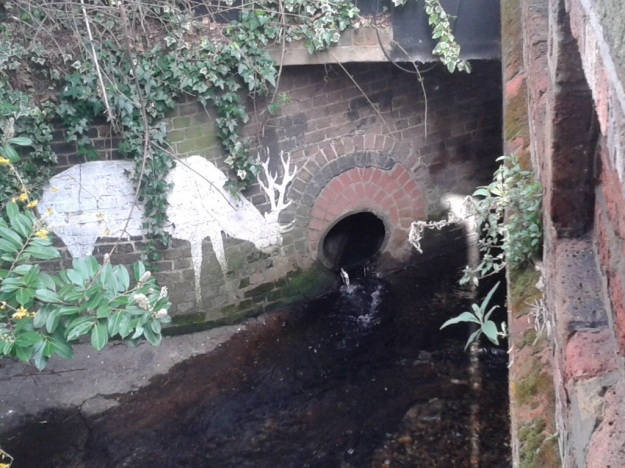
About a hundred metres on, we reach the Quaggy – another three way boundary in 1893 with Eltham replacing Kidbrooke. There is another boundary marker by the bridge over the Quaggy, its a defaced one of a similar style to that at the beginning of this section – rumour has it that the places were hacked out so as not to offer any help to German troops in the event of an invasion. There is though a better boundary marker almost below it though; by the outflow of the culverted Mid Kid Brook which as it joins the Quaggy is another Lewisham Natureman stag. This is the final one in the quartet of stags we have spotted on or close to the Lee boundary, so it seems an appropriate place to finish the circuit.

Notes

  1. Neil Rhind (forthcoming) Blackheath and Its Environs Volume 3

The Postcards are via eBay from 2016, apart from the one of Christ Church which is from a couple of years before.

Census and related data is via Find My Past (subscription required)

This, and the rest of the series of posts on the Lee boundary, would probably not have happened without Mike Horne, he was the go-to person on London’s boundary markers; he had catalogued almost all of them in a series of documents. He was always helpful, enthusiastic and patient. He died of a heart attack in March but would have loved my ‘find’ of a London County Council marker in some undergrowth on Blackheath during 2020’s lockdown, and would have patiently explained the details of several others he knew to me. A sad loss, there is a lovely series of tributes to him via this link.

Lee Working Men’s Club – a Lost Lee Road Watering Hole

A while ago Running Past covered the Lee Working Men’s Institution which was initially on Boone Street but later at 87 Old Road.  There were several questions on Facebook threads about whether the Institute was in some way linked to the Lee Working Men’s Club that used to be at 113 -115 Lee Road.  The short answer was ‘no’, and those that set up the Institution on Boone Street would probably have been appalled by the thought – it had strong links with the Victorian temperance movement noting that ‘their great rival’ was the public house (1)

So what of their near namesake on Lee Road?  The Lee Working Men’s Club & Institute (I’ll drop the & Institute to avoid confusion) first appeared in Kelly’s Directories in the late 1920s – over 30 years after its near neighbour at 119, the Lee Constitutional Club, Conservative was added later; maybe something on that another day. It could well have been a little earlier than this as Kelly’s Directories were sometimes a year or two behind changes in business on the ground and there was no entry for the address in the 1920s.

The houses had been built well before the Ordnance Survey cartographers arrived in the mid-1860s (see buildings highlighted above) – it was probably constructed soon after the railway arrived in Blackheath in 1849.  However, as just post war maps make clear – while current site numbering is 111 to 115, it hasn’t always have been this.  111 was originally part of a pair of Victorian semi-detached villas next door to the site and what was the Working Men’s Club was 113-115. So not to confuse matters  the numbers used will be the current ones.

In 1896 111, the building at the side,  was used by  John Walls to carry on a Dairy business, he’d been previously listed as a ‘cow keeper’ in Kelly’s since an early one in 1884 – presumably keeping his small herd in the still rural land toward Eltham.  113-115 was the private dwelling of Charles Valentine Game – Game was appropriately a butcher, who had lived in Burnt Ash Lane in the 1860s.  115 was then referred to as ‘Holland House.’  Game seemed to live there until his death in 1894.

In the first decade of the 20th century John Walls departed and presumably the outbuilding at the side was incorporated into the main house. It became home to a private school, initially run by Valentine Johnson and then Warwick Wyatt Crouch.  The school had closed its doors by the time the 1911 Kelly’s Directory was compiled and the house was home to Major Ernest Edward Bruno.

The next occupant was the Working Men’s Club at some stage during the 1920s. There were some early recollections of the Club in some local memoirs.  Regular readers will recall that a while ago Running Past covered the ‘Sunday Constitutional’ that the Noble family’s men used to have in the late 1920s and early 1930s Lee, starting from a house in Lampmead Road. It was something covered in the memoirs of their daughter who was to become Phyllis Willmott, a noted Social Work and Social Policy academic. In that post the menfolk, with children in tow, went to various hostelries in Lee and Blackheath whilst the women stayed at home to cook the Sunday dinner.

Evenings had been spent downstairs (Phyllis and her immediate family had most of the 1st floor at 49 Lampmead Road) around her gran’s piano. However, as the children got older, it seems as though this was replaced with drinking outside the home, to which both the children and their mother were allowed to come too. The destination was Lee Working Men’s Club (2).

It was clear that this was something that Phyllis wanted to do but wasn’t allowed to come every week – her prayers at Boone’s Chapel often included requests to be allowed to the Working Men’s Club (3). (This is what is now Emmanuel Pentecostal Church, rather than the Grade II listed 17th century one further down Lee High Road).

When Phyllis and her family started going to Lee Working Men’s Club there was strict demarcation inside. Women and children were generally only allowed in the Hall at the side, what is now 111 (4). There was a regular dance night at the Club some Sunday’s in the Hall. The beer befuddled men would make a late appearance for the last waltz, generally poor dancers they would be guided around the dance floor by their more sober wives and girlfriends (5).

When it was warm enough the dances and events were held in the garden which had a ramshackle external bar, and a couple of sheds selling – jellied eels, horseradish and the like at one and saveloys and sandwiches at the other.  The horseradish was locally grown – harvested from the side of the railway close to Hither Green station (6).

Perhaps surprisingly, there are few on-line memories of the Club – a Facebook thread from earlier in 2019, had positive memories of being a Club that seemed child friendly, with several generations of the same family having almost grown up there. There were recollections too of bands and being in bands that played there.

While its doors were still open when the StreetView car passed by in June 2008 (see above), ‘sale agreed’ signs were outside when the next drive past occurred in the autumn of 2009.

So what went wrong?  Apart from the more general changes in drinking patterns, the most likely explanations are both local and national.  The haemorrhaging of office businesses from Lee Green (Osborne Terrace and Leegate) along with the closure of the Police Station a little further down Lee High Road meant that the clientele for lunchtime or post work drinks was considerably reduced.  There was competition too in the cheap beer market with Wetherspoons opening the Sir Edmund Halley in Leegate.  The factors were importnant too in the closure of two Lee Green pubs – the Prince Arthur and the New Tiger’s Head. Nationally, the smoking ban introduced in 2007 may well have sounded the death knell for the Club.  It is obvious though from comments on a Facebook thread that the closure caused some bitterness and disagreement amongst members.

By 2012 the site was split the hall, formerly 113, now 111, was (and still is) a Pilates studio and the main building is a nursery – part of a chain – Zoom, itself part of a larger chain Bright Horizons.

Notes

  1. Kentish Mercury 09 March 1867
  2. Phyllis Willmott (1979) Growing Up in a London Village p124
  3. ibid p125
  4. ibid p126
  5. ibid p127
  6. ibid p128

Credits and Thanks

  • The photograph of the Club when it was still operating is via StreetView in 2008
  • Kelly’s Directory information comes via Southwark Local History Library and Archive
  • The photograph of the garden is  copyright of  Lewisham Archives and is used here with their permission
  • Census and related data come via Find My Past

The New Tiger’s Head – A Lee Green Pub

One of the more depressing sites at the Lee Green crossroads is the slowly decaying New Tiger’s Head; it ought to be a focal point but the decline on such an impressive building was sufficient for the Victorian Society to include it on their 2017 list of 10 most endangered Victorian and Edward buildings – previous local listings have included Ladywell Baths.  Oddly, for such an impressive building, it isn’t nationally listed, and took until May 2019 to be even locally listed by Greenwich.

The New Tiger‘s Head started life as a beer shop known as the Tiger Tavern in the 1830s – it was a name that, off and on, it retained into the early 20th century. It was at the western end of a group of four cottages known as Prospect Terrace which were built at around the same time and had the same ownership. These cottages remain, housing a post office/newsagent and a hairdresser’s.  To confuse matters, it was partially on the site of its near neighbour the (Old) Tiger’s Head which had moved to its current location in the mid-18th century.

So what was a beer shop or house?  It had its roots in earlier social problems caused by excessive consumption of gin – made famous by Hogarth’s prints on the evils of Gin Lane and the relative merits of Beer Street in the 1750s – see below (1).  In the 1820s and 1830s governments were attempting to deal with widespread drunkenness through gin drinking which had partially arisen through high levels of taxation on beer.  The Beerhouse Act of 1830 abolished the tax on beer and allowed the opening on premises that could only sell beer and apart from an annual 2 guinea licence fee there was only limited control over their opening and limited regulation.  This was very different to the strict regime that existed for public houses which could sell wines and spirits too.  The beer house was the starting point in licencing terms for many Victorian public houses and there were often long campaigns to get turn the beer house licence into a full pub licence.

By 1841 the New Tiger’s Head seems to have been a successful business, it was described as being ‘intended for a licensed house, doing an extensive trade’ it was sold with the four neighbouring cottages – the lease was for 80 years with a ground rent of £17 a year (2).

In the 1840s seem to have seen the first recorded applications for a full licence for the New Tigers Head in 1847; unsurprisingly, it was opposed by Charles Morton, landlord of the Old Tigers Head opposite (3).

By 1849 the landlord was William Charles Pickup, he made the third application for a full licence – it was based on the growth of area and coming of the railway.  It was again opposed by Charles Morton, and was again refused by the bench – who noted that if Pickup ‘ever expected to gain a licence, he must conduct his house in a better manner.’ (4).

Pickup was a relatively young man, just 27 when the census enumerators called in 1851 Census. Pickup sold up in 1853 and there was a sale that year of assorted household possessions and a ‘light gig with excellent springs, patent axels, leather cushion etc.’ (5).

Each September the case for a full licence seems to have been made to the magistrates, and it was refused in 1856 (6) and the following year a petition against the request was presented to the bench ‘ numerously signed by the clergy and resident gentry of the place.’  It was again refused (7). The opposition from the clergy and the gentry shouldn’t be seen as any form of tactic support for the Mortons and their running of the Old Tiger’s Head; rather it was an opposition to drinking and pubs per se.  Much of the same group were behind the setting up of Lee Working Men’s Institution in 1854 in Boone Street.  Despite its name, it was no working men’s club and promoted the expansion of knowledge and abstinence. Running Past will return to this in the future.

James Phillips, described in the 1861 census as a refreshment house keeper, took over the licence in the late 1850s.  He used the petition tactic with his application getting support from several farmers and market gardeners of the area – perhaps including Richard Morris at Lee Green Farm, (pictured below from the information board at Lee Green) William Brown at College Farm, Thomas Adams of Burnt Ash Farm and Thomas Blenkiron at Horn Park Farm.

It was again opposed by the landlord of the Old Tigers Head, now Caroline Morton, mother-in-law of John Pound (soon to be owner of the Northbrook).  She used a different tack in the opposition to that used by her late husband, claiming the name would be too similar. Phillips suggested that it was a requirement of his lease, but he would be happy to call it ‘The Monkey’ or any other animal to get a full licence (8).  Unsurprisingly, the licence was refused, although a licence for selling wine (but not spirits) was granted later that year following new legislation (9).

Phillips, who was married to Martha and employed two live-in bar maids and a waiter in 1861, had another application rejected in 1861(10) but, after an adjournment in 1863, he finally obtained a full licence (11).

Almost as soon as Phillips had obtained the licence he sold his interest to Marchant Bowyer Warner, presumably it was worth much more than it had been as a beer house (12).

Phillips had planned to extend the frontage of the beer house in 1863, but permission had not been granted (13).  However, Warner was quick to extend – adding a billiard room in 1865 (14) along with some other alternations in 1866 (15) and a new sign, which required permission, the same year (16).

Warner was only 28 when he took over the tenancy in 1864; it wasn’t his first licence though – he’d been the publican at the Duke of Wellington in Shacklewell for just over a year before that.  Whether he had inherited wealth or the now fully licensed New Tiger’s Head was very profitable indeed, he was listed as a retired Licensed Victualler living in nearby Cambridge Drive by 1881.  He stayed in Cambridge Drive for the next three censuses and died in Lewisham in 1921.

There was a series of landlords in the 1880 and 1890s, with Edward Dicker (1881), John Stevens (1883) and Emma Porter all being licensees (17).  There were then brief interludes of Frederick Morgan (18) behind the pumps, followed by George Rose (19). Arthur Strutt Lindus took over soon after and was fined £8 12s for watering down beer in late 1894 (20). Lindus had been a licenced victualler before at the Heaton Arms in Peckham in the 1871 and 1881 censuses.

Source eBay September 2016

The pub seems to have been re-built in its present form in the late 1890s, a year or two after the Old Tiger’s Head on the opposite corner of Lee Road.  The landlord when it re-opened was probably Neville Dedman, part of a family with a strong tradition of running pubs.  Most recently, his father William had been publican at the Old Tiger’s Head before it was rebuilt in 1896.  Despite all press reports noting it as the New Tiger’s Head, it was listed as the Tiger Tavern again in the census.

For reasons that aren’t clear William, who lived a short way up Eltham Road, took over the tenancy in 1902 (21). He was eyeing up other options though and got permission to build the Station Hotel in Hither Green in 1905 (22).  Sadly, he died in 1906, the year before the Station Hotel opened and his widow, Jane, was to become the licensee. Neville was in control though by the time the census enumerators called in 1911. Neville saw out his days in an appropriate location for the pub keeping traditions of his family, at the beautiful, on the outside, at least, Licensed Victuallers Benevolent Institution Asylum Road in Peckham (See below – on a Creative Commons via Geograph) in 1939 Register.

John Reynolds from Cambridgeshire took over the tenancy in 1904, with his wife Elizabeth who hailed from Hitchin, and remained there until his death in 1914.

Albert James Bromley succeeded the Reynolds for 5 years but the long term licensee was Robert Prichard who took over in 1921 and was certainly there in the 1939 Register, then aged 71 with Agnes who he had married in 1925.  They had 5 live-in staff to help them run the business.  Robert probably remained there until his death in 1945.  It probably wasn’t his first licence as a Robert Pritchard of right age was running Red Lion, 1 Eldon Street, Shoreditch in 1901.

The pub ceased trading in 2005; it was no doubt the victim of a number of factors  – cheap supermarket drinks and some of the local factors that led to the demise of the nearby Prince Arthur – the closure of the police station and the slow haemorrhage of offices from Leegate House and Cantilever House (above the Leegate Centre).  There are suggestions too that the owners, Enterprise Inns ‘ran this place into the ground’, although the arrival of Wetherspoons’ Edmund Halley about 50 metres away with its cheaper beer and more welcoming feel at around the same time was probably more pivotal in its demise.

The building isn’t completely empty, the upper floors have been turned into 6 flats – with an annual rental income of over £70,000 – the interior has been recently had some emergency works undertaken to secure the interiors from further damage following discussions with both Lewisham and Greenwich Councils.   As Joe O’Donnell has noted (see comments below) – there was an unsuccessful application to Greenwich to turn the ground floor into flats in 2016.

At the time of writing (March 2018), the freehold is on sale with offers of £2.5 million sought. Ironically, when the plans for St Modwens redevelopment of the Leegate were first mooted there were suggestions that Wetherspoons might move to the New Tiger’s Head, although there has been nothing recent in the local media on this.

Unlike many other closed local pubs, there haven’t been pages of memories posted on Facebook – maybe there hasn’t been a trigger to do it… So, if you worked there or drank there, tell your story, who were the characters who propped up the bar, the landlord, the staff,  the atmosphere, the memorable nights, the particular celebrations that were held there, memories of the friends, the beers.  Post them below (you can use your Facebook or Twitter login – or via Facebook (if you found the post via here) – if it is you first comment ‘here’, you will have to wait for it to be ‘moderated’.  I will update the post with comments.  Anything libellous though will get deleted here & no doubt on the Facebook Group pages.

Notes

  1. On a Creative Commons via Wikipedia https://en.wikipedia.org/wiki/Beer_Street_and_Gin_Lane
  2. 12 October 1841 – Morning Advertiser – London, London, England
  3. 28 September 1847 – Kentish Mercury – London, London, England
  4. 06 October 1849 – Kentish Mercury – London, London, England
  5. 10 September 1853 – Kentish Mercury – London, London, England
  6. 27 September 1856 – Kentish Independent – London, London
  7. 25 September 1857 – Morning Advertiser – London, London
  8. 29 September 1860 – Kentish Mercury – London, London, England
  9. 10 December 1860 – Morning Advertiser – London, London, England
  10. 28 September 1861 – Kentish Mercury – London, London, England
  11. 26 September 1863 – Kentish Mercury – London, London, England
  12. 21 May 1864 – Kentish Mercury – London, London, England
  13. 21 March 1863 – Kentish Mercury – London, London, England
  14. 11 November 1865 – Kentish Independent – London, London, England
  15. 14 April 1866 – Kentish Independent – London, London, England
  16. 25 August 1866 – Kentish Independent – London, London, England
  17. 17 February 1883 – Woolwich Gazette – London, London, England
  18. 29 August 1890 – Woolwich Gazette
  19. Kentish Mercury 13 February 1891
  20. London Evening Standard 10 December 1894
  21. 29 August 1902 – Kentish Independent – London, London, England
  22. 10 March 1905 – Kentish Mercury – London, London, England

Census & related information come via Find My Past

Following the Quaggy – Sutcliffe Park to Lee Green

In previous posts, Running Past has followed the Quaggy from its sources around Locksbottom and then on through Petts Wood, the Hawkwood Estate, Chislehurst and Bickley, through the golf courses of Sundridge Park and on to Chinbrook Meadows.  Most recently, we left he river at on the south side of Eltham Green Bridge, by an old London County Council sign, wondering about how to moor a boat there.

North of the bridge, over Eltham Road, is Sucliffe Park; until the early 20th century the area was farmland, The Quaggy meandered through the fields as the map below shows (on a Creative Commons from the National Library of Scotland).  Woolwich Borough Council acquired the land just after World War 1.  It was named after the then Borough Engineer (1).

The meanders had been removed by the time that the Ordnance Surveyors cartographers visited again in 1938 and encased in concrete – as the map below shows (on a Creative Commons from the National Library of Scotland). The river was completely enclosed at some stage during the post war period, Ken White believed it to be around 1970 (2) although several on Facebook threads thought it was much earlier than this.

The look that remained until the current Millennium was of a flat, featureless park (apart from the athletics track that is home to Cambridge Harriers, whose early history was covered a while ago.  It was reminiscent of a miniature Hackney Marshes (Photo below on a Creative Commons via Restoring Europe’s Rivers wiki)

In Facebook threads on upstream posts, there were lots of memories of playing in the Quaggy and culverts around the Park, seemingly including some of the streams that join the Quaggy – notably Well Hall Stream.

This all changed in 2002. A new meandering channel was created for the Quaggy, close to its pre-1930s course, albeit at a slightly lower level, with the park itself being remodelled to create a flood plain able to store 85,000 m³  with a series of boardwalks, viewing points and a large pond. The old channel was retained for extreme flood situations and flow can be switched to it when the storage in the park is full (above, right photograph).

The park which used to be rarely visited other than for weekend football is now a well-used focal point and reconnecting the community with the river and its natural environment – it is often held up as an excellent example of urban river management. Unlike other parts of the Quaggy’s catchment, it is beginning to be used as a place of play and discovery – children can sometimes be seen jumping across the river, there were reminiscences about doing this in Mottingham, feeding ducks on the pond along with the occasional sightings of fishing nets and buckets.

The Quaggy was originally joined by Well Hall Stream in the park, although when followed a while ago, there was little evidence of any current flow.

The river goes through some complex engineering that can shut off the flows in periods of high water, and re-emerges the other side of Kidbrooke Park Road in the playing fields of John Roan School.  Here too the river has changed, the concrete encasement had continued west of the road, I remember having to scramble down angled concrete to fish out footballs from the river during my sons’ Saturday morning football practice there. 

The Quaggy is theoretically joined by Lower Kid Brook (above) opposite a rather impressive Woolwich Borough marker (below left), or rather it isn’t any more – the flow was probably diverted into the Quaggy three hundred metres to the east in Sutcliffe Park.

Beyond John Roan playing fields, the river is sandwiched between Lyme Farm Road estate, which replaced Victorian housing, and Crofton Albion FC.  It emerges out into the public gaze again at Weigall Road where the 1903 boundary markers from Woolwich had again been busy (above right).

Over the road, to the south, there is another series of playing fields – the first is a public one, Weigall Sports Field which was once home to Ravensbourne Athletic Club’s grass running track.  It was part of a residential club and sports centre for employees of Cook, Son and Co (St Pauls) Ltd. which was a clothing wholesale company – the building faces on to Eltham Road (see above) and was completed in 1912.  Prior to then there were newspaper reports of them being based in Ladywell Fields, hence the name from a different catchment.  The building on Eltham Road was requisitioned for World War 1 billeting but returned to its former use after the War.  It continued as this until after World War Two when it was converted into flats – it is now part of Ravens Way (perhaps a shortening of the club’s name) (3).

Its next door neighbour is the Bowring Group Sports Ground (below), although its days in recreational use are probably numbered as it seems to have been acquired for  a ‘Free’ School.

The northern banks of the Quaggy also used to have playing fields, the just post war Ordnance Survey map shows cricket grounds (on a Creative Commons from National Library of Scotland.) The outlines of the fields are still there and indeed the derelict remains of one the pavilions remains.  The formerly manicured grounds have been largely abandoned and now form part of the Weigall Road flood defence and storage, although the intention has always been dual use.

It isn’t meant to be an accessible area, but fences on Weigall Road and Blackheath Park are always porous enough for the runner of a smaller stature to enter without having to resort to contortions or scaling boundaries.  It the last long section of the river where the Quaggy has a bucolic feel – it probably hasn’t changed much since the fields by the river were used as the venue for the horse racing of the Lee Races in the first half of the 19th century.

The flood defences have a second fence to prevent the fluvial flâneur but in a period of low flow they proved to be of limited deterrent.  Apparently the Weigall Road storage will hold 65,000 m³ of water.

There is/was probably a small tributary joining around here.  There is very boggy ground just south of the derelict pavilion, more standing water in wetter seasons but still pooling in a very dry Spring.  There is an occasionally running stream which forms the boundary between the fields, in recent years I have only seen water there in the very wet winter of 2013/14.

On Facebook pages relating to upstream posts, there are fond memories of playing in and on the banks of the Quaggy in these parts – there still sometime cross river swings with a ducking for those with poor grips, although none have been noticed for a year or two.

Beyond the Weigall Road flood storage area, the Quaggy briefly disappears before being bridged by Meadowcourt Road and then flowing onwards towards Osborne Terrace.  The river is then bridged by Lee Road, there was only a footbridge until as late as the 1860s, as the 1863 published 25″ Ordnance Survey shows (on a Creative Commons via National Library of Scotland). The road bridge was certainly there by the time the cartographers returned in 1893.

This was an area of flooding – Hastead reported depths of 10′ (3 metres) in the 18th century and F H Hart reporting similar depths after the rapid thaw following the bitterly cold 1813/14 winter, there was flooding over a wide area including a lot of Lee Park.  Hart reported flooding being a regular occurrence in the early 19th century with a Bromley farmer drowning in 1830.

There is another Woolwich marker from 1903 by the bridge, only someone has chiselled out – the borough name, perhaps they were going to return and add Greenwich, but they never did.  Next to the bridge there is a pipe with water entering the Quaggy, with a Lewisham Natureman stag ‘grazing’ next to it, this is the diverted Mid Kid Brook.  On the opposite bank, there is a ghost sign for a ‘carver and gilder’ (more here), oddly hidden by the current cafe owners.  We’ll leave the river here for another day.

Notes

  1. Ken White (1999) The Quaggy & Its Tributaries p25
  2. ibid p25
  3. John Coulter (1997) Lewisham and Deptford in Old Photographs: A Third Selection