Tag Archives: Lewisham Natureman

Beating the Bounds of Lee, Part 8 – Blackheath to Lee Green

We’d started our circuit of Lee at Lee Green during the first 2020 Coronavirus lockdown and the last leg from Blackheath to Lee Green was under the not dissimilar conditions of lockdown 2.0 in the late autumn of 2020. In the intervening months, Running Past followed the long thin boundary of Victorian Lee just before it was subsumed into Lewisham in 1900. The navigation was aided by an 1893 surveyed Ordnance Survey map.

This circuit has been in seven stages up to this point, from Lee Green to Winn Road, passing a street whose residents probably now wish it had a different name – Corona Road; the next stage was through Grove Park; then on through Marvels and Elmstead Woods; the circuit skirted Chinbrook Meadows and followed the appropriately named stream Border Ditch; then another Ditch, Hither Green Ditch, more or less parallel to Verdant Lane and Manor Lane before following the Quaggy from Longhurst Road into Lewisham, then in the penultimate part following a Quaggy tributary, Upper Kid Brook to Blackheath.

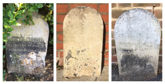
We’d left the boundary at a T junction of borders, Lee – Lewisham – Charlton with a replacement of a 1903 boundary marker of a similar style to those seen in several places around the border.

Source – eBay (Sept 2016)

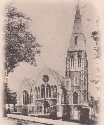
The stone is next to the railway bridge and it is worth a quick turnaround by the first turning on the left, or would have been in 1893. A large Methodist chapel had been built in the mid-1860s and dominated the Blackheath Village skyline and was to do so for another 52 years until a V-2 rocket attack hit it in March 1945.

The turning is Bennett Park, which has one of biggest concentrations of blue plaques in south east London – the Physicist, Sir Arthur Eddington lived at number 4 – he was listed as a boarder there in the 1911 census, whilst working at the Royal Observatory. The cartoonist Donald McGill, lived at 5 Bennett Park – he was there when the 1939 Register was compiled. But, perhaps, the most significant is one at the far end for the GPO Film Unit, whose output included the wonderful film adaptation of W H Auden’s Night Mail, which featured a score by Benjamin Britten. The Film Unit also produced some World War Two propaganda films. The building had been partially funded by one the main benefactors of late Victorian Blackheath, William Webster, son of the eponymous main contractor of Joseph Bazlegette, as Blackheath Art Club.

Onwards and southwards, the boundary goes upwards and out of the valley of Upper Kid Brook towards the watershed with the adjacent Brook in the trio of Kid Brooks, Mid Kid Brook. Straddling the catchments is a pair of elegant buildings at the top of the hill – the Conservatoire of Music and Blackheath Concert Halls, again in part the paid for built by William Webster. Both were a few years away in 1893 though, there was a terrace of houses there at that stage. The Concert Halls, resplendent with some lovely pargeting, were to be the location of a badly disrupted suffragette meeting in 1909.

Lee Road, which we follow to Lee Green and the end of our circuit, had been farmland on the western side until 1835 (1) – this was a little later at the Lee Green end which in some years was the home to the annual horse racing of Lee Races. The eastern side, part of the Cator Estate, had seen some development from a couple of decades earlier. We won’t look at much of the housing here in any detail as Neil Rhind’s meticulously researched Blackheath Village and Environs Volumes 2 &3 cover this.

By 1893 though, this was wealthy suburbia and there was still farmland to the west. In the period since, the mix of housing has changed considerably – the area around corner of the Lee Road and Blackheath Park (pictured above from early in the 20th century) is perhaps, typical of them – with Victorian housing replaced by Span housing of which there are lots examples dotted around the Cator Estate (pictured from a similar location in 2020).

The Charlton – Lee boundary continued, unmarked, along the centre of Lee Road in 1893; on the western side the view would probably have been dominated by the Christ Church on Lee Park. The area had once been part of the parish of St Margaret’s but the burgeoning population saw the parish split several ways, Christ Church (pictured below from Lee Park) being the first to be carved out in the 1850s. It lasted until ten days into the Blitz when Luftwaffe bombs destroyed most of it with the remaining parts demolished before the end of the war.

The church wasn’t the only part of the urban landscape to suffer during the war. There was damage of sufficient volume for there to be two small estates of prefab bungalows – Lee Road Bungalows just to the north of what is now Heathlee Road and River Close, which was opposite Manor Way. The section between them and onwards to the south was re-developed in the 1960s. The postcard below shows the street scene in that part of Lee Road in the early 20th century looking towards Blackheath – the boundary going down the middle of the road.

Just to the north of Manor Way, there was another T junction of boundaries – Lee remained constant but on the eastern side Charlton became Kidbrooke. The 1893 Ordnance Survey map noted a boundary stone, but this alas is no longer there. The Charlton – Kidbrooke boundary had followed Mid Kid Brook through the Cator Estate. The Brook’s original course would have been across Lee Road but during the 18th century it was diverted down Lee Road, it is currently culverted.

The was very little bomb damage on the eastern side of the boundary beyond Manor Way, with most of the houses that would have been there in 1893 remaining. One of the original houses was taken over as Lee Workingmen’s Club at 113 -115 Lee Road in the 1920s, the Club (pictured above) closed this century and is now a nursery . The Lee Constitutional Club was two doors down but arrived just too late to quench the thirst of the Ordnance Survey cartographers.

The 1863 and 2020 boundary continues down the middle of the road, now with Greenwich rather than Kidbrooke. Like the streetlights, bins, paving, white lines and tarmac colours that have become informal boundary markers, Lee Road has another variant – a small island in the road.

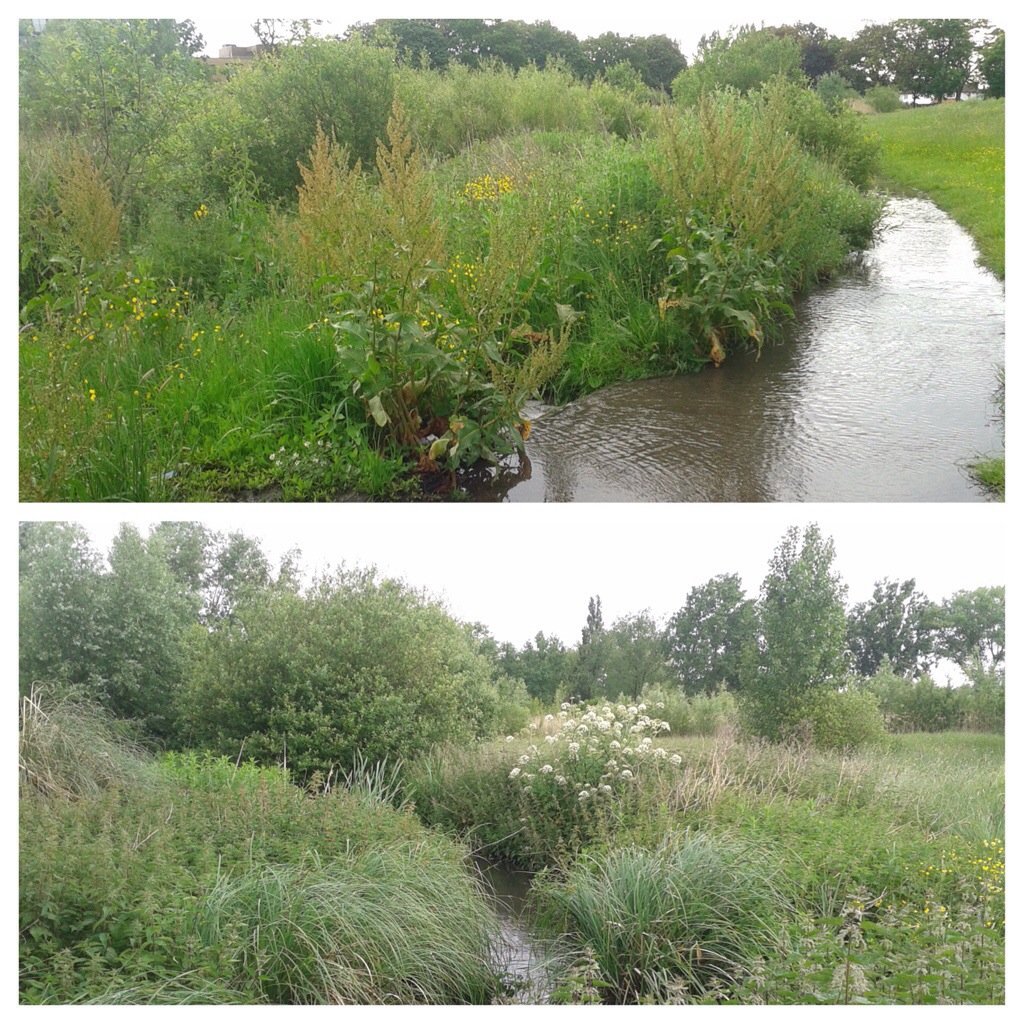
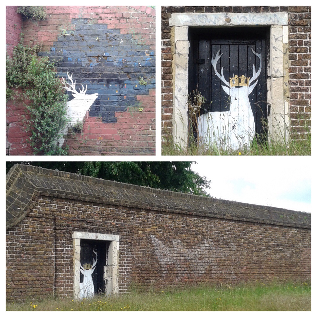
About a hundred metres on, we reach the Quaggy – another three way boundary in 1893 with Eltham replacing Kidbrooke. There is another boundary marker by the bridge over the Quaggy, its a defaced one of a similar style to that at the beginning of this section – rumour has it that the places were hacked out so as not to offer any help to German troops in the event of an invasion. There is though a better boundary marker almost below it though; by the outflow of the culverted Mid Kid Brook which as it joins the Quaggy is another Lewisham Natureman stag. This is the final one in the quartet of stags we have spotted on or close to the Lee boundary, so it seems an appropriate place to finish the circuit.

Notes

  1. Neil Rhind (forthcoming) Blackheath and Its Environs Volume 3

The Postcards are via eBay from 2016, apart from the one of Christ Church which is from a couple of years before.

Census and related data is via Find My Past (subscription required)

This, and the rest of the series of posts on the Lee boundary, would probably not have happened without Mike Horne, he was the go-to person on London’s boundary markers; he had catalogued almost all of them in a series of documents. He was always helpful, enthusiastic and patient. He died of a heart attack in March but would have loved my ‘find’ of a London County Council marker in some undergrowth on Blackheath during 2020’s lockdown, and would have patiently explained the details of several others he knew to me. A sad loss, there is a lovely series of tributes to him via this link.

Beating the Bounds of Lee, Part 5 – Verdant Lane and Manor Lane

During the 2020 Coronavirus lockdown, Running Past has been following the boundary of Victorian Lee before it was subsumed into Lewisham at the end of the Victorian era, aided only by a Second Edition Ordnance Survey map. We have so far wandered, in stages, initially from Lee Green to Winn Road, appropriately passing Corona Road en route; the second stage took us through Grove Park, crossing the never built Ringway;  then through Marvels and Elmstead Woods and a Borough of Deptford Cemetery; and in the previous instalment through Chinbrook Meadows appropriately following Border Ditch. We pick up the 1893 Lee – Lewisham boundary on what is now Downham Way – the most southerly of the red dots on the map below.

The Downham estate was built by the London County Council (LCC) in the late 1920s and early 1930s on compulsorily purchased farm land. On this side of the estate included what was probably the last outpost of the land owned by the Baring family, Shroffold Farm, pictured later in the post.  We will probably return to the farm at some stage in the future. However, the farm was part of the Manor of Lee bought by Sir Francis Baring, later Baron Northbrook, the purchase of which was at least partially funded by both financing of slave owning operations as well as some direct ownership on enslaved people. While the Barings dispensed largesse to the locals in their latter years, their ability to do this was based, in part at least, on the enslavement of African men, women and children in Montego Bay in Jamaica at the end of the 18th century.

We’d split our circuit of Lee at the top of what was described in a 1790 map as ‘Mount Misery’, better known these days as Downham Way (the most southerly dot on the map). There was a lot of ‘misery’ in the area in that era. South Park farm, which was to become North Park – a little further down the hill in our broad direction of travel was a farm that for a while was known as Longmisery.

The reason for the split in the post at Mount Misery was that the boundary in 1893 had changed soon after the brow of the ‘Mount’ from field edge to stream at the boundary.

Before leaving this point, it is worth remembering that at the time the Ordnance Survey cartographers surveyed the area they would have had an undisturbed view almost to the north of the parish and St Margaret’s Church. Certainly this was what the local Victorian historian, FH Hart, noted in the early 1880s when following the boundary from this point.

The stream is Hither Green Ditch; a stream that Running Past followed a while ago which has several sources. The nomenclature ‘Ditch’ is used quite a lot within the Quaggy catchment, it shouldn’t be seen as belittling or derogatory it is just the way smaller streams are described – the 1893 boundary of also followed, Grove Park Ditch and Border Ditch, with Milk Street and Pett’s Wood Ditches further upstream.

This branch of Hither Green Ditch seems to have emerged somewhere around Ivorydown, south and above Downham Way. It merges with the 1893 Lee – Lewisham boundary just north of the street named after the farm, Shroffold. The merged boundary and stream followed the middle of Bedivere Road.

The section that the Lee-Lewisham boundary initially followed, is one of the sections of Hither Green Ditch that is barely perceptible on the ground, although the contours are clear on early 1:25,000 Ordnance Survey maps, if not current ones. Whether this part of the stream was actually flowing in 1893 is, at best, debatable, water tables had declined after the end of the Little Ice Age, the last really cold winter was in 1814 – with extensive flooding around the parish of Lee when there was a thaw.

The boundary and stream followed the edge of a small piece of woodland in 1893 which is now an area bordered by Pendragon, Ballamore and Reigate Roads. There is an attractive U shaped portion of the latter, where council surveyors struggled with dampness from the hidden Ditch.

The post war 1:25,000 Ordnance Survey map, notes a flow at around the point of Railway Children Walk, an homage (or a homage) to E Nesbit who lived on the other side of the railway – on of at least a trio of locations within the Parish she resided in. A small detour is worth making for a view of another Lewisham Natureman stag standing proudly above the railway.

Detour made, the boundary follows Hither Green Ditch which was marked as flowing in the 1960s 1:25,000 Ordnance Survey map, so was presumably also flowing in 1893. To the west of the Ditch, and boundary, was Shroffold Farm, the farmhouse (pictured below from the 1920s) was where the mosque is now located – diagonally opposite to where the Northover/Governor General was to be built 40 years later at the junction of Verdant Lane, Northover and and Whitefoot Lane. To the east was almost certainly land belonging to Burnt Ash Farm – both sides of the boundary owned by the Northbrooks.

While fields in 1893, this area is now part of Hither Green Cemetery. It originally opened as Lee Cemetery in 1873 but with a much smaller size at the northern end of the current one. Like the Borough of Deptford cemetery we passed through in Grove Park, it was outside the jurisdiction it served, all on the Lewisham side of Hither Green Ditch. There are two impressive chapels, the Dissenters one (for Methodists and the the Baptists of Lee High Road and what is now Baring Road), was built by William Webster of Blackheath and was damaged during the last war and is slowly decaying.

The southerly end of what is now the cemetery had changed from farm land to allotments in the early part of the 20th century. The exact timing of the expansion of the cemetery into the allotments isn’t clear, it was probably just before or just after the start of World War 2, it was showing as allotments in the 1938 surveyed Ordnance Survey map. But by the time the children who died in the awful attack on Sandhurst Road School in early 1943, were buried the area had expanded. There is a large memorial to those who perished, something covered in a blog post that marked the 75th anniversary of the bombing in 2018. The crematorium in the south east corner was opened in the 1950s.

The 1893 boundary is relatively easy to follow on the ground through the cemetery as Hither Green Ditch has left a small valley close to the Lombardy poplars that border the railway.

Just outside the cemetery in 1893 was a small hospital, Oak Cottage Hospital; it had been built in 1871 by the local Board of Works for dealing with infectious diseases like smallpox and typhoid (1).  It was overtaken by events in that the Metropolitan Board of Works (which covered all of London) decided to open a series of fever hospitals as a response to a major Scarlet Fever epidemic in 1892/93, the health system was unprepared and there was a severe shortage of beds.  One of these was the Park Fever Hospital, later referred to as Hither Green Hospital; Oak Cottage Hospital was briefly considered as a possible alternative location (2).   Oak Cottage Hospital closed soon after Park Fever opened in 1896 (3).  It eventually became housing in the 1960s or 1970s.

Beyond Oak Cottage Hospital in 1893, were again fields, probably part of Shroffold Farm. On the opposite side of Verdant Lane (then Hither Green Lane) was North Park Farm, about to be ploughed under by Cameron Corbett. The Lee Lewisham boundary continued to use Hither Green Ditch which was to remain visible until the development of the Verdant Lane estate in the 1930s. This section is pictured below, probably soon after the Corbett Estate was completed around 1910.

In addition to the Ditch, there were a pair of long gone boundary markers, one was just to the north of the junction of Verdant Lane and Sandhurst Road, perhaps at the point one of the confluence of two of the branches of the Ditch; the other where it crosses St Mildreds Road – again a possible branch of the Ditch that would have been obliterated by the railway.

St Mildreds Road hadn’t existed when the Ordnance Survey cartographers had first visited in the 1860s. While the church of St Mildreds had been built in 1872, even in 1893 only homes at the Burnt Ash Hill end had been build, including another of the homes in the area of E Nesbit in Birch Grove.

The boundary went under the railway close to what was a trio of farm workers cottages for North Park Farm, which are still there at the junction of Springbank Road and Hither Green Lane.

The boundary continued to follow Hither Green Ditch – it wasn’t just a Parish boundary at this point, but a farm boundary too – on the Lewisham side, Hither Green’s North Park Farm, which was mainly on the other side of the railway and was sold at around the time that the land was surveyed and would form the Corbett Estate. On the Lee side was Lee Manor Farm, which is pictured on a 1846 map below (right to left is south to north, rather than west to east) and Hither Green Ditch which had several small bridges is at the top.  There were several boundary stones and markers along what was broadly Milborough Crescent and Manor Lane.  There was then a sharp turn to the east along what is now Longhurst Road.

The confluence of Hither Green Ditch with the Quaggy was in a slightly different place in 1893, then it was more or less where 49 Longhurst Road is now located; it is now around 40 metres away on a sharp corner between between Manor Park and Longhurst Road, as pictured below.

We’ll leave the boundary of Lee and Lewisham here for now following what is now the Quaggy into Lewisham in the next instalment.

This series of posts would probably not have happened without Mike Horne, he was the go to person on London’s boundary markers, he had catalogued almost all of them in a series of documents. He was always helpful, enthusiastic and patient.  He died of a heart attack in March but would have loved my ‘find’ of a London County Council marker in some undergrowth on Blackheath, and would have patiently explained the details of several others he knew to me.  A sad loss, there is a lovely series of tributes to him.

Notes

  1. Godfrey Smith (1997) Hither Green, The Forgotten Hamlet p54
  2. Woolwich Gazette 02 June 1893
  3. Smith op cit p54

Picture Credits


Beating The Bounds of Lee Part 2 – Winn Road to Grove Park

In the last post, we returned to the old tradition of ‘beating the bounds’ of the civil parish of Lee, ‘armed’ mainly with a Second Edition Ordnance Survey map of the area and a decent amount of local knowledge of the history. The survey for the map had been carried out in 1893, but it seems to have updated to reflect boundary changes relating to Mottingham in 1894.

We had left the Lee boundary on Winn Road, part of a small estate developed by William Winn, which, appropriately for the time this post was written, includes Corona Road.

The route followed is the red line on adjacent Ordnance Survey map. It was broadly the same circuit that had been followed in 1822 by the great and the good of the parish. Included in their number, although not in the ‘good’ part, was the final tenant of Lee Place, the odious Benjamin Aislabie – a slave owner after slavery was abolished in the Empire. At least the parish spelled his name incorrectly as ‘Aislibie’ when naming a street after him.

This image has an empty alt attribute; its file name is af0690cd-be10-40de-8e36-558916f75f88.jpeg

We had left the boundary at the final of a trio of 1903 Lewisham boundary markers at the south easterly junction of Winn and Guibal Roads. Lee was merged with Lewisham into the Borough of Lewisham in 1900. The 1893 boundary was about 15 metres to the west and cut across to what is now Burnt Ash Pond, mid way down Melrose Close. The current Lewisham boundary with Greenwich veers off to the east down Winn Road to the Quaggy.

Burnt Ash Pond is usually a delightful little oasis of calm, but seemed to be suffering from lock down, seemingly covered with either duckweed or green algae when passed by on this occasion. The 1893 variant of the boundary passed through the Pond and continued southwards down Melrose Close, attractive late 1970s council housing, diminished by an entrance through largely abandoned garages. In 1893 the boundary passed through back gardens parallel to Burnt Ash Hill, almost opposite College Farm. There is an 1865 Lee Parish marker hidden in the undergrowth next to the pond, although it is not visible from the outside.

The name ‘Melrose’ came from another farm which seems to have evolved out of Horn Park Farm, whose farm yard we crossed in the first post, and was essentially a market garden operation and was also referred to as Woodman’s Farm, after its tenants. The Close was probably part of its land. Its farmhouse in Ashdale Road remains and was used as a site office for the developers of much of the area we are about to pass through, Wates. The farm’s main claim to fame was the unintentional landing of Willows II (pictured below) which was aiming for Crystal Palace and in the process created a record for the longest airship flight.

This image has an empty alt attribute; its file name is image.jpeg


The boundary continues parallel to Burnt Ash Hill until a point almost opposite Ashwater Road when it follows what are now the rear fences of houses on the northern side of Senlac Road, presumably named after the likely location of the Battle of Hastings. In the back garden of a group of Wates built interwar semis between Exford and Ashdale Roads, there was once the junction of the parishes of Lee, Eltham and Mottingham. The house with three boundaries, then had two and now has none – the Bromley boundary is now at the bottom of the hill following the Quaggy. The change is a relatively recent one, dating from 1991 proposals, the current resident remembers paying council tax to both Lewisham and Bromley. In 1893 we would have been in fields.

The 1893 boundary broadly followed what is now an access road to the rear of houses in Jevington Road. The end of Jevington Road has a chain link fronted jungle facing it, the boundary pierces through the chain link, on the Mottingham side of the 19th century border is now a Den of a former Dragon, a Bannatyne Health Club. The Lee side is, arguably even healthier – some allotments, along with a community volunteer run library.

This image has an empty alt attribute; its file name is c184c1fd-fb72-4fc1-aba9-0217594ac8ee.jpeg

This section would have been very different if the Conservative run Greater London Council (GLC) plans for Ringway 2 had come to fruition in the late 1960s. In South London, it was essentially a motorway replacement for the South Circular.

There was much secrecy about the detail of the route, although the most likely version suggested by Chris Marshall would have seen a five lane motorway driven through the allotments, with a minor interchange for Burnt Ash Hill and a major one on Baring Road. There was much opposition across south London to the scheme, and the absence of a motorway here points to its success. The only tangible remains of Ringway in the area is an eponymous community centre on Baring Road.

Returning to 1893, when the Ordnance Survey cartographers visited, the Grove Park Hospital had yet to be built – that wouldn’t be for another 15 years. We’ve covered the hospital when we followed the Quaggy through these parts.

On the northern wall is a boundary marker – the ‘MP’ is clear in that it relates to Mottingham Parish which from 1894 to 1934 was a ‘detached’ part of the Bromley Rural District. The ‘LP’ is less clear, Lee had disappeared into Lewisham by the time the hospital was built, but it was the Borough of Lewisham rather than the parish.

In 1893 the parish of Lee meandered across the soon to be hospital site, changing direction at a tree that doubled up as a boundary marker. The tree is long gone, presumably felled when the hospital was constructed and the boundary moved to the edge of the hospital site. Oddly, in the housing that replaced most of the hospital buildings, there is a tree at the same point as the former boundary marker.

On the eastern side of the hospital site, Lee’s boundary takes on a new format, the Quaggy. Rivers and streams often form the boundaries between parishes and local authorities, as we have found with several streams and rivers – including the River Wilmore in Penge and Border Ditch that we will encounter later in our perambulation around Lee.

Alas, the conterminous boundary with the Quaggy (shown top left below) only lasts for around 50 metres, about 2 and a half chains of Victorian measurement. However, we swap one watercourse for another as the boundary veers off the the east, following Grove Park Ditch, which depending on rainfall levels either cascades or splutters into the Quaggy (top right, below).

The confluence is a pipe opposite the Sydenham Cottages Nature Reserve, named after the farm workers cottages above. The nomenclature ‘Ditch’ is used quite a lot within the Quaggy catchment, it shouldn’t be seen as belittling or derogatory it is just the way smaller streams are described – there also are Milk StreetBorder and Petts Wood further upstream.

About 50 metres inside the Lee side of the boundary, Lewisham Natureman has been recently active – a new stag has been painted, drinking from the Quaggy (or would be in more typical flows) in the shade of an elder bush. We will return to his work at a few other points on our travels around the Lee boundary.

The course of Grove Park Ditch isn’t certain, it is culverted for almost half a mile, but would have crossed the fields below more or less parallel to a very rural looking Marvels Lane from 1914, presumably coterminous with the boundary.

There is a boundary marker outside 94 Grove Park Road. It is weathered and unreadable, but marks the Lee boundary with Mottingham – given the style is similar to those around Winn Road at the beginning of this section it probably dates from 1903, however, the location of the boundary was the same in 1893.

In the next instalment, we will follow the boundary through the rural Grove Park of 1893.

Picture Credits

  • The Ordnance Survey Map is via the National Library of Scotland, it is used here on a non-commercial licence
  • The picture of Willows II is from an original postcard in the authors ‘collection’
  • The Ringway map comes from Chris Marshall’s fascinating website
  • The postcard of Grove Park is from e Bay in November 2016

The series of posts on the Lee boundary that this post is part of, would probably not have happened without Mike Horne, he was the go-to person on London’s boundary markers; he had catalogued almost all of them in a series of documents. He was always helpful, enthusiastic and patient. He died of a heart attack in March but would have loved my ‘find’ of a London County Council marker in some undergrowth on Blackheath during 2020’s lockdown, and would have patiently explained the details of several others he knew to me. A sad loss, there is a lovely series of tributes to him via this link.

Five Months On

It’s five months since my life was re-arranged by a Fiat Punto, while it is getting back towards normal, but is still some distance off, but still infinitely better than it might have been.

Life rather feels dominated by rehab work – near weekly trips to the physio and at least an hour a day of strengthening exercises and stretches, there is no alternative though – if I want to regain full fitness and range of movement I have to do them, and slowly, very slowly I am improving.

Running is still hard work, after three months of a relatively sedentary lifestyle my leg muscles had largely forgotten about the faster forms of pedestrianism and they grumble about every run when I start. But the running is progressing – I am coping with ‘faster’ sessions again – this week’s was a mile at just under 8 minute mile pace. At full fitness that would be around 6 to 6:15 pace, but it is real progress.

image

The distances I run are increasing – my long run is now over 5 miles and will hopefully get up to around 10k this week. Hills are becoming bearable – I toiled up to the top of Crystal Palace on Friday, but it was easier than Greenwich Park 10 days before. The views from the decaying remains of the burnt out Palace were surprisingly clear, the Sphinx on the way down always seems a mixture of slightly surreal and delightfully familiar, a trip to the Park isn’t the same without seeing one of them, and a little further down the hill, but no less surreal are the rotting remains of the 1970s Concert Bowl, once a stage for the likes of the Beach Boys, Lou Reed and Eric Clapton but now dangerous and unable to be used.

And finally ….. ‘grazing’ in the dappled shade, I spotted another Lewisham Natureman stag escaped from its home borough, outside the former entrance to Thomas Tallis School in Kidbrooke.
image

Reflections on the Rivers Ravensbourne & Pool

As I recover from an accident, I am still a while off running but my urban wanderings always seem to draw me back to my regular running routes.  

This week my still (slightly) short days at work have left me with time to follow the Rivers Pool and Ravensbourne from Sydenham back towards Lewisham.  It seemed slightly odd not running, but it gave a rather different perspective.  

Monday’s leaden skies saw me focus on the both the mural under the bridge near Bell Green – which was painted a couple of years ago, but I have never stopped and looked at – plus the more industrial and metallic elements of the route.  


Friday morning should have seen a partial eclipse and, given the juxtaposition of it with the vernal equinox, meteor showers and the aurora borealis being visible in parts of Britain, it would have had our ancestors heading for the henges and hills.  Sadly it was just 50 shades of grey in London (photo by @weareblackheath).  


The afternoon though was almost perfect spring weather – clear, mild and sunny.  I niddle-noddled along paths alongside the river, which I don’t usually use – tending to stick to the smooth tarmac – to save time on my run to work and to make intervals or tempo runs safer on the run home; it made a wonderful change.


I also spotted several reflections, which at a faster pace I would have undoubtedly missed.


Any wanderings of a fluvial flâneur would not be complete without the sight of a semi-submerged, upturned shopping trolley, one was spotted in the reflection of the Riverside Building of Lewisham Hospital – an odd cocktail of drugs on a past stay there left me convinced of the presence of dayglo squirrels in the adjacent Ladywell Fields. 


Sadly only grey squirrels were visible this week, and alongside the rivers a green woodpecker, a heron and the iridescent blur of a kingfisher was seen a couple of times.  It was two spottings of different wildlife that oddly pleased me more – Lewisham Natureman stags – one by the Ravensbourne under the road bridge in Catford, the other shyly hiding in the corner of the former Ladywell Leisure Centre site as I went from the Ravensbourne to the Quaggy catchment.


Ghost Signs – Frederick Stimpson, Carver and Gilder

Going north along Lee Road, from Lee Green towards Blackheath, the road crosses the River Quaggy and, at head height, on a building by the side of the bridge, is (or was) a ghost sign.  It is an odd location and painting much of it would have presumably have involved wading through the Quaggy, carrying ladders under the bridge from Osborn Terrace, with the ladder standing in the river whilst painting the sign.

20140612-203531-74131996.jpg

Other than the ‘F Stimpson’s’, ‘…works’ in the middle and ‘fine’ on the bottom row of lettering, it is difficult to decipher what remains – due to a combination of several layers, re-pointing and age. However, census data and Kelly’s Directories are of assistance – it is a sign for Frederick Stimpson who ran a carving and gilding business at 120 Lee Road, the side of the building on which the sign is located.

20140612-203643-74203132.jpg

So what was gilding and carving?  The carving element would relate to carving wood for furniture and picture frames; in some some cases it might also involved carving an shaping, plaster on ceilings.  The gilding part was applying gold leaf. A newspaper advert for a similar business in Burnt Ash Road in the 1890s focused on the picture framing part of it (1).

Frederick Stimpson was born in Killower, in rural County Galway 15 miles north of the city of Galway in 1876. His family had moved back to London, via Sussex where his sister was born, as by 1881 he was living at 29 Horton Street, just off Loampit Vale, in Lewisham.  His parents were William, was a ‘naval pensioner’ of 39 from Sheerness, and  Mahala who was from Messing in Essex.

By 1891 he was living in Footscray Road in Eltham with his family and was listed as a Cabinet Maker’s apprentice aged 15, perhaps with his brother William.  He married Annie (nee White), who hailed from Bexleyheath in 1900 and by 1901 he was listed in the census as living over the shop at 120 Lee Road.

He had probably only moved to Lee Road a year or two before the census – in 1896, 120 was occupied by Edward Lynch a picture frame maker . Over the next 10 years Annie and William had four sons, and the business was clearly successful as they were able to afford a live-in servant, Jessie Parsons who came from Islington.

Frederick died in 1935, still living at 120 Lee Road and was buried in the churchyard of St John the Baptist at the top of Eltham Hill.

The widowed Annie was still living over the shop in 1939 – listed as a picture dealer. Also there were two sons Harold (1901) and Geoffrey (1907) along with a lodger.  Both the sons were listed as married but there was no sign of their wives at Lee Road.

120 Lee Road was listed as Blackheath Galleries in 1940, whether this was a re-branded business with Annie at the helm isn’t clear either way though, it didn’t survive the war – the shop was empty in 1945. A similar business emerged in 1950 called C C Ham, a picture framer, but with no obvious link to the Stimpsons. It was a business that remained until the late 1960s since when it has been a series of takeaways.  The first, perhaps not one for a speedy service was a Chinese restaurant called ‘Slowboat.’

Edward Lynch’s business in 1896 wasn’t the first (or last) business to trade from the shop.  It makes for an interesting slice through retail history – hosiers Morton & Co were there in 1884, Albert Barnes a hosier and outfitter in 1888, in 1892 the short-lived Blackheath Gazette carried adverts for a W Francis who was a ‘Dyer, Cleaner, furrier and plumassier (someone who works with feathers),  a Miss E Francis who had dropper the second two bits of her father’s (?) trade in 1894.

20140612-203724-74244111.jpg

The ghost sign was still visible when this post was first written in 2014, but seems to have been boarded over by the current occupants of the shop, The Vintage Fish, who moved in around 2016.  Long term. this will protect what remains of the sign which is badly faded.  Those partial to painted artwork on bricks may still want to pay a visit to the site, as opposite, at river level, is one of the best examples of the Lewisham Natureman stag, ‘grazing’ by the diverted outflow of Mid Kid Brook.

Notes

  1. Kentish Mercury 27 January 1893

Credits

  • The Kelly’s Directory data comes via Southwark Archives
  • Census and related data is via Find May Past (subscription required)

The Slow Road to Recovery

It’s nearly three weeks since I last posted about my running, the recovery from the lateral collateral ligament strain picked up during the London Marathon has been slow to say the least. Until this week that is, a week ago I was considering having a complete break for two or three weeks but over the last 7 days it finally seems to have cleared up with nothing felt in 5 runs including a tempo run today round a rather soggy Sutcliffe Park where The Quaggy was rather full and one of the paths had become a temporary tributary.

20140526-220355-79435850.jpg
During the last couple of weeks I have ‘discovered’ some more of Lewisham Natureman’s deer – one in Cressingham Road in Lewisham

20140526-220516-79516334.jpg
The second, less than a mile away, wearing the Saxon Crown of the Borough’s badge, is on an abandoned gate in a listed wall on Blackheath, which, despite being able to walk around, has its own crown of broken glass.

In Search of Mid Kid Brook

I have known about the Kid Brooks for years, having done a little on-line trawling in the past to try to understand why Blackheath Village, whose contours would suggest that it is in a river valley which extends into Lewisham, seemed to be devoid of any waterway. The ‘discovery’ of the Upper Kid Brook (now with its own post) and its course through ‘The Village’ led to the realisation that there were two other Kid Brooks and that the end of the Lower one was on a playing field I knew well.

It is thus entirely logical then to start with the third Brook, Mid Kid Brook. Its source, according to the fantastic and usually reliable Edith’s Streets, is to the east of the Brook Hospital site, possibly from a pond at the former Hill Farm, (the entrance to which was around where Corelli Road is now). The source was probably covered when the Brook Hospital site was originally developed, and a ‘gated community’ was built after the Hospital closed around where the source may well have been. One of the few remaining bits of the fever hospital site is the old Water Tower, and for the want of a more tangible source, it seems as appropriate starting point for following the course of the Mid Kid Brook.

20140402-223517.jpg
Maps produced prior to the development of the area show the Brook flowing westwards, parallel to Shooters Hill Road, passing the former Brook pub (now a Co-op). Certainly at that point it could not be too far away from the main road at the land falls away to the south about 30 metres away from the road.

The first ‘sounding’ of the Brook may be in the London Marathon Playing Fields – there is a large manhole cover and a sound of running water underneath. It may just be wishful thinking on my part though, given the topics the blog covers.
&gtbr br />20140402-225726.jpg
Edith’s Streets has the Brook flowing parallel to Shooters Hill Road to opposite Marlborough Lane latterly behind a parade of shops, although there is nothing there to show its course in the jumble of dumped rubbish, broken fences and abandoned outbuildings. Just beyond there the Brook turned back sharply on itself at a farm that has long since disappeared – Arnold’s Farm.

The name lives on though with a sheltered housing scheme, in the general location of the farm – Arnold House. There are parallels with the modern housing at the former Brook Hospital site, between 1881 and 1948 it was the site of the Blackheath and Charlton Cottage Hospital (the Cottage being dropped just before WW1). The small dispensary is all that remains of one of a large number of hospitals on Shooters Hill Road.

20140402-223706.jpg
The pre-development map of the area has the Brook meandering south-west towards the current A2. The exact route is difficult to work out, although the on the ground contours would probably suggest a route that included Begbie Road, the playing fields on Wricklemarsh Road, and going behind houses on Holbourne Road and crossing Woolacombe Road just north of Dursley Road – just to the north of the former location of Manor Farm before crossing what is now the A2.

On the far side of A2 the exact locations become a little clearer, aided and abetted by a street name, Brook Road, and some gentle contours, which sees the Brook flowing under the edge of a small meadow behind St. John Fisher church and then under the church drive.

Opposite the church, on the other side of Kidbrooke Park Road, is our first sighting of the Brook – emerging from underneath the road and running alongside Thomas Tallis School.

20140402-223923.jpg
While it is then apparently visible as the boundary alongside the Blackheath Girls School playing fields, there is no public access. The next clues as to its course are on Casterbridge Road on the Cator Estate where the contours and manhole covers with the sound of water underneath suggest a likely route.

The next sighting is more obvious, the pond on Casterbridge Road. This is likely to be the remains of one of the former ponds from the Wricklemarsh Estate (the other being on what is now Pond Road), certainly the Mid Kid Brook originally fed a pond in roughly this location.

20140402-224103.jpg
The remains of a bridge over the Brook are still there and there is a clue as to the course in a street name, Brookway, after which it crosses Foxes Dale and its route becomes apparent again (although without any obvious sign of water, but oddly it is marked on various modern maps in blue) between two houses before disappearing in a sink in the garden of a house on Lee Road, as I confirmed a few weeks ago.

The sink takes the Brook across Lee Road, where there used to be a small bridge, before following a the western side of the road a couple of hundred metres to Lee Green where it joins the Quaggy next to the Lewisham side of the bridge..

Its final outflow from a pipe provided a picture of what I would have imagined happening further upstream perhaps 300 years ago – a deer drinking from the Brook. Alas it is not a real one, but it is the next best thing, and one that is rather more permanent feature – one of the delightful works of Lewisham Natureman, that appear in all sorts of odd places – a Blackheath Banksy perhaps?

20140402-224241.jpg

This post is a part of a series on the Quaggy and its tributaries which are brought together here.

Postscript – a later post suggests than the current course from the ‘sink’ may not have been the original one and that Mid Kid Brook may have originally flowed westwards, roughly along the line of Lee High Road, to join the Quaggy nearer Lewisham.