Tag Archives: Hither Green Lane

One Night in the Blitz – the Air Raids on Lewisham of 8 December 1940

Last year Running Past looked at two of the most intense nights of World War Two bombing in Lee on the 27 and 29 December 1940.  We turn our attention to a night earlier in December 1940 when Lee, Hither Green and parts of the Corbett Estate were again hit  – the night of 8-9 December 1940 – most of the bombs fell in a short period around 11:00 pm on the Sunday evening.   

As was the case with the raids almost three weeks later, Lee wasn’t the real target and was a stopping off point on a major raid on London during which German bombers dropped over 380 tons of high explosive bombs and at least 115,000 incendiaries. 250 Londoners were killed on 8 December and 600 more seriously injured. Several streets in Lee, such as Brightfield Road (below), were hit in both raids.

As we have found with other posts on the Blitz, including the first night and the raids on 27 December and 29 December 1940, it is worth remembering that not every incident was reported to the Air Raid Precautions (ARP) HQ at Lewisham Town Hall, some being just reported to the Fire Brigade but others never going through official channels. This is particularly the case with incendiary bombs which residents were often able to put out themselves.

This particular night was clearly chaotic at the ARP HQ with some incidents clearly being reported and/or written up several times – as far as possible the narrative and maps have attempted to strip out the duplicates. There were around 70 incidents reported in just Lee, Hither Green and the Corbett Estate with no doubt lots not reported and large numbers elsewhere in the old Borough of Lewisham.

So, what were incendiary bombs? They were cylindrical bombs around 35cm long, and 5cm in diameter. Inside was a mechanism that ignited an incendiary compound that filled the cylinder, thermite, on impact. They were often dropped in ‘breadbaskets’ typically containing 72 incendiaries.

There appear to have been at least three ‘breadbaskets’ dropped on Lee at around 10:50 pm– one around Wantage Road, another on Burnt Ash Road, although the numbers were smaller there and a third around Brightfield Road. There were around 70 incendiaries that the ARP logged – with most, the note on the log was ‘fire put out without significant damage to property.’ The fires in Brightfield Road were of a different class to those elsewhere though– the ARP log noted that they were ‘distinguished’ – presumably a typo. Several of the houses in the postcard above were hit, whilst the photograph was taken over 30 years before, the street scene, that much will not have changed by 1940. The locations recorded from the raid in Lee are mapped below.

There were relatively few injuries – those that there were tended to be from the aftermath and/or trying to put out fires – four were injured in Burnt Ash Road, including a child who was blinded at 90 Burnt Ash Road and an ARP warden was injured in Micheldever Road.

At around the same time as incendiaries rained down on Lee several were dropped around what was then Campshill House in Hither Green Lane, Ryecroft and Campshill Roads (at the top of the map below).  A few minutes later there were a couple in the streets to the north of Brownhill Road – Ardgowan and Springbank Roads (there is a separate post on attacks on Springbank Road.) There were also incendiaries dropped in Fernbrook Road – 67 and 101 were both damaged along with another two at 127 Manor Park and Leahurst Road area (see Lee map above).  No doubt a few more fell but weren’t recorded.

At about 11:05 it seems that a ‘breadbasket’ was dropped on the eastern side of the Corbett estate with several hits on Verdant Lane and a lot falling in Minard Road (pictured below) – although they mainly landed in the street. Whilst this would have destroyed cars in 2021, this presumably wasn’t much of an issue in 1940.

While in the main, it was incendiary bombs that hit Hither Green, Lee and the Corbett Estate that night, there were a few high explosive bombs dropped too. The earliest was in Nightingale Grove at the junction with Maythorne Cottages (the eastern side of the ‘tunnel’ and current main entrance to Hither Green station.) It failed to explode, but the road was closed and, presumably, residents evacuated at around 10:00 pm. Three and a half years later, more or less the same location was hit by a V-1, causing several deaths and the destruction of a lot of homes.

Around 45 minutes later another one exploded at the junction of Mount Pleasant and Fordyce Roads causing a crater in the road and damaging the water supply.  Another unexploded high explosive bomb was reported at 59 St Mildred’s Road around 1:00 am, it was probably dropped earlier in the evening and the residents were evacuated.

The most destructive high explosive bomb was reported at 11:30 pm – at the junction of Dacre Park and Eton Grove, close to Lee Terrace.  Two houses were demolished and several others were damaged beyond repair.  Dacre Park was blocked for a while and four were reported as being injured. 

One of those injured was William John Sherriff, a 21-year-old merchant seaman from Port Talbot in South Wales; William was taken to Lewisham Hospital but died there the following day.

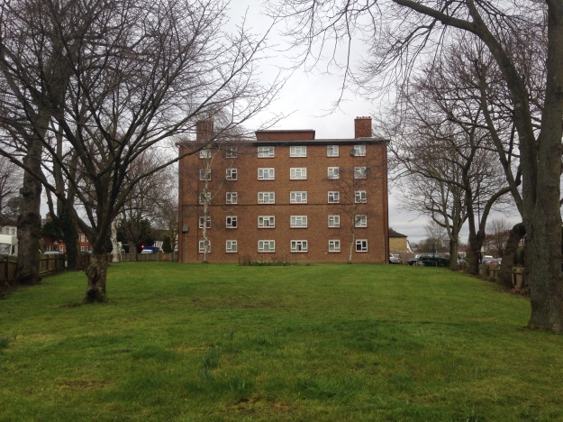
While of a similar size to the site from the Fernbrook Road V1 and several around Boone Street, the old Brough of Lewisham did not prefabs built on it; the site was cleared and flats built on it soon after the war, pictured below.

As noted earlier, Lewisham wasn’t the primary target of the raid – the bombers moved on towards central London where a high explosive bomb demolished the south and east sides of the Cloisters of St Stephen’s Chapel within the Houses of Parliament. The BBC buildings in Portland Place were badly damaged that night too.

Notes

  • In several locations the term ’many’ was used in the ARP log – this includes the both the eastern and western sides of Burnt Ash Road, Effingham Road (around the current Brindishe School), the eastern end of Burnt Ash. In these cases, I have assumed at least four incendiaries fell.  Some also aren’t exact – one group of four were noted as being on Micheldever between Wantage and Burnt Ash Roads.
  • The numbers are undoubtedly an underestimate – incendiary bombs that harmlessly fell in gardens or roads probably wouldn’t have been reported.

Credits

  • Most of the information for this post comes from the Lewisham ARP Log – it is a fascinating document, which is part of the collection of Lewisham Archives.
  • The postcard of Effingham Road is via eBay in February 2018
  • The maps are created via Google Maps

World War Two Damage on Springbank Road

There have been several posts in Running Past on World War 2 bombings and post-war reconstruction, many of these have been around V-1 and V-2 attacks such as those on Lenham Road, Lewisham Hill, along with a pair of Hither Green ones – Nightingale Grove and  Fernbrook Road.  More recently Running Past has covered the attacks that happened on three nights on their 80th anniversaries – the First Night of the Blitz of the as well as the post Christmas raids on the nights of 27/28 and 29/30 December 1940.  We turn our attention now to the more widespread damage on Springbank Road caused through a variety of attacks. 

Key: black=total destruction, purple=damaged beyond repair, dark red=seriously damaged (doubt if repairable), light red=seriously damaged (repairable at cost), orange=general blast damage (non-structural), yellow=blast damage (minor), green=clearance area

The level and scale of damage becomes clear when looking at the London County Council Bomb Damage Maps pictured above (1) which shows that most of the houses in the street had some form of damage.  Rather than Springbank Road itself, Hither Green marshaling yards, behind the eastern side of the street, were one of the two main Luftwaffe targets in Hither Green during the Blitz, the other being the hospital (2). The damage was much greater to Springbank Road though than to the west of the railway. 

Large swathes of the street were mapped as red by the London County Council surveyors – ‘seriously damaged (doubt if repairable)’ or worse.  In reality, a lot more end up surviving the war than the map suggests.

The Air Raid Precautions (ARP) Service logs make for fascinating reading in terms of trying to work out what damage happened when in Hither Green and the extent of the damage.  However, as we’ve seen in relation the First Night of the Blitz as well as the post-Christmas raids, recording in the log was patchy at best with some high explosive and incendiary bombs only being recorded by the Fire Brigade and others, which were dealt with by local ARP Fire Wardens, were never recorded.

On the third night of the Blitz, on 9 September 1940, it is clear that 136 Springbank Road was hit.  What is less clear is whether this was a direct hit or the fallout from the bombing of the house behind at 51 Wellmeadow Road. This was the house was on the corner with Torridon Road and marked in black on the map above and was completely destroyed. This part of Wellmeadow Road was rebuilt after the War.  William Brown (83) and Alice Budd (56) died at 51 Wellmeadow Road that night. 

136 Springbank was less badly damaged, although it seems to have undergone some wartime or post-war rebuilding work as from the front from the variety of slightly different bricks were used.  One of the inhabitants was Mary Hutcheson – it was a large house that she shared with a couple – the Gallotts.   Mary was seriously injured in the bombing, although she lived for another 6 months before dying at St Alfege’s Hospital (later Greenwich) on 10 March 1941, aged 82. 

Elsewhere on Springbank Road, there was some serious damage further down the street with 213 to 225 completely destroyed. The date of this bombing isn’t clear as the attacks appear not to have been recorded in the ARP log (3).  Unlike 136 Springbank, no one was killed in the attack, although given the scale of the damage it would be surprising if there were no injuries.  213 to 225 (pictured above) were rebuilt as a mixture of Borough of Lewisham houses and flats after the war.  On the other side of the street, there was destruction and rebuilding too, but you have to look closely to see the differences compared with the original Corbett estate homes – the brickwork around the doors and windows is different and the homes are similar to replacement houses in Wellmeadow Rod, which we’ll cover below.

Elsewhere on the eastern side, homes got away with some more limited damage; there had to be re-building work at 211; while its next-door neighbour didn’t survive, the roof, chimneys and bay wall had to be re-built at 211.

There had were several nights during December 1940, notably that of 29/30, when the area on the other side of the railway had seen 1 kg incendiary bombs raining down.  Springbank Road escaped on those nights. However, three weeks earlier on the night of 8/9 December, there had been a similar attack over a slightly wider area – there were a trio of hits at just before 11:00 pm at the southerly end of Springbank Road – none of the repots had any indication of the extent of any damage or casualties.  It could have been the attack that destroyed 213 to 225, as the fire services will have been overstretched that night, although incendiary damage tended to be of a much smaller scale and often put out by wardens.

V-1 doodlebug attacks started to pepper the area from 16 June 1944 – in Hither Green and neighbouring areas, during the first week there had been attacks between George Lane and Davenport Road on 16 June; Lewisham Park the same day; Lewisham Hill and Leahurst Road on 17 June and the junction of Lenham and Lampmead Roads on 22 June. 

Research on the accuracy of V-1s has noted that they had ‘relatively low accuracy… compared to modern missile systems’ but that the aim of the attacks was ‘to achieve its terror and urban damage objectives’ rather than hit specific targets.  So, V1 flying bomb hits on Hither Green and surrounding areas weren’t specifically targeted here.  Indeed, as we have mentioned in other posts on V-1 attacks there is some evidence to suggest that false intelligence was spread back to Germany which indicated that the early V-1 flying bombs were overshooting the north west of London and latter ones were re-calibrated slightly leading to south London boroughs such as Lewisham, Woolwich and Croydon being disproportionately affected.

At around 7:15 in the morning of Friday 23 June 1944 Hither Green had a double hit either site of the railway – Fernbrook Road, which Running Past covered a while ago and Springbank Road; where the block of Corbett Estate housing of 104 to 116 Springbank Road was either destroyed or had to be demolished along with the similar houses behind in 27-37 Wellmeadow Road – the scale of debris blocked Springbank Road for a while.

It was perhaps surprising that only one person died, Annie Taylor (57) who was visiting 110 Springbank from her home at 121 Brightfield Road – Annie was a widow and had lived with her son and daughter in law.  There were several reports of the level of injuries in the ARP log – which were thought at one point to be as high as 25, although final tally seemed to be 14. 

We don’t know the identity of those injured but from the 1939 Register we can work out something about the people who were living in 104 to 116 Springbank Road and the houses behind in 27-37 Wellmeadow Road.  Before doing that, it is worth remembering that the houses had been built as suburbia for the middle classes of Victorian and Edwardian London.  The houses in Springbank Road were some of the later ones built on the Corbett Estate and didn’t appear in the 1901 census, but were in the 1911 edition. The difference between Springbank Road and nearby streets such as Ardmere Road in 1911 is dramatic.  The latter had been built as working class housing with the small houses generally shared between two households with income coming from manual work.  In Wellmeadow and Springbank they were office and sales jobs – with several commercial salesmen and clerks along with a cashier and an accountant.  There were no manual jobs apart from servants in 3 of the 11 houses.  Despite the large houses, large households were rare – it was a very different life to that in Ardmere Road.

By the time the 1939 Register was taken, both streets had changed a lot – the middle class had moved out and both Wellmeadow and Springbank Roads were homes to manual workers, the only exceptions being the adult Spurrell sisters at 112 Springbank – which included Edith who was a Ledger Clerk at a bookshop but also worked as an ARP First Aider.  They were more well-to-do than their counterparts in Ardmere Road and Woodlands Street, the households were smaller and there was less sharing.  Only 108 Springbank and 31 Wellmeadow were split between more than one household.  None of the men (or women) were able to claim the ‘Heavy Work’ supplement which entitled larger rations

The housing built after the war on both Springbank and Wellmeadow sides of the site seems to have been private sector; this is unlike many of the other V-1 attacks that Running Past has covered – Hither Green Station, Lenham/Lampmead Road, Lewisham Hill and Fernbrook Road where it was homes built for the local authority.  On Springbank Road 104 to 116 (pictured above) were re-built, initially as houses although most have been converted into flats. Based on Land Registry data, most remain in the private sector although one has been subsequently acquired a housing association. It was very different in Wellmeadow where the houses seem to have been built almost as 1950s versions of their predecessors – again all but one are privately owned, with one has been bought and converted into flats by a housing association.

Notes

  1. Laurence Ward (2015) The London County Council Bomb Damage Maps 1939-1945 – permission has been given by the copyright owners of the map, the London Metropolitan Archives to use the image here
  2. Godfrey Smith (1997) Hither Green, The Forgotten Hamlet p63
  3. It is possible that some mentions were missed when scanning through the very fragile records

Data Sources

  • The ARP records are via Lewisham Archives
  • 1939 Register data is via Find My Past – subscription required
  • Land Registry data is via Nimbus Maps – registration required.
  • The photograph of 136 Springbank Road is via Streeview

A Walk through Hither Green’s History

Hither Green has a rich and interesting history; this post was written to ‘accompany’ a walk organised as part of the 2018 Hither Green Festival, it can be used to independently to walk the route (its a circuit of around 1.8 miles) or as virtual tour of the area.  The ‘walk’ is divided into sections which relate to the planned stopping points – each of which is full of links to other posts in the blog which will have more detailed information.

Starting Point – Before the Railway

Hither Green station is the perfect place to start the walk as the railway ‘made’ the area.  At the time of the railway arrived in Hither Green in the 1860s, it didn’t stop – it was to be a junction until the mid 1890s.  When the South Eastern Railway navvies constructed the embankment and cutting through the area, Hither Green was largely rural, surrounded by farms as the map below shows – the farms including several covered by Running Past – North Park, Burnt Ash and Lee Green.

Hither Green Lane was there with several large houses but the main population centres were outside the area – the elongated Lewisham stretching all the way along what is now the High Street and Rushey Green, the three parts of Lee – Lee Green, the area around the church and Old Road, the latter with the Manor House and the farm and servants housing of Lee New Town.

While Hither Green remained a junction until the 1890s, the edges that were closer to other stations started to be developed – for example Courthill Road started to be developed from 1867, Ennersdale Road during the 1870s.  Then roads like Brightside, Mallet and Elthruda began to be developed in the late 1870s and early 1880s.  Everything changed with the opening of Hither Green Station on 1 June 1895 – the area lost its rural feel, most of the remaining large houses were sold and the Victorian and Edwardian houses and ‘villas’ built.

The Prime Meridian is crossed and marked in the pedestrian tunnel at Hither Green station, most of the walk will be in the western hemisphere..

Springbank Road & Nightingale Grove

A V-1 attack on devastated the area on the western side of the station on 29 July 1944 killing five  and destroying a significant number of homes, as the photograph (below) from the now closed ramp up to Platform 1 shows. It was one of 115 V-1 rocket attacks on Lewisham that summer – the most devastating had been the previous day when 51 had died in Lewisham High Street. Soon after the war nine prefab bungalows were put on the site; with the council bungalows probably appearing in the early 1960s.  The Beaver Housing Society homes on the corner of Nightingale Grove and Ardmere Road also replaced some of the homes destroyed – there are glazed tiles naming the landlord which is now part of L & Q Group.

© IWM Imperial War Museum on a Non Commercial Licence

Ardmere Road (covered in a 2 part post) was built in the 1870s but was considered one of the poorest in the neighbourhood by Charles Booth’s researcher Ernest Aves in 1899 – he described it as one of the ‘fuller streets, shoddy building, two families the rule.’ It was marked blue – one up from the lowest class.

The area was looked unfinished to Aves and there was even a costermonger living in a tiny tin shack with their donkey on the unfinished Brightside Road in 1899, along with a temporary tin tabernacle. This immediate area was very poor and in ‘chronic want’ compared with the comfortable middle class housing of much of the rest of the area.

Hither Green Community Garden

The Community Garden dates from 2010 – cleared and maintained by volunteers from Hither Green Community Association.

North Park Farm

The Community Garden would have been part of the farmyard for North Park Farm.  It was latterly farmed by the Sheppards, although the land was owned by the Earls of St Germans until the sale to Cameron Corbett in 1895 – there are already posts on both the farm itself and in the early days of the development.

There were two Sheppard brothers both of whom had houses – one of the farm houses remains at the junction of Hither Green Lane and  Duncrievie Roads (see above) – along with their long term farm manager William Fry, who lived in the original farm building around the Community Garden..

The shops (see below) were developed by Corbett early in the development – there was no pub as Corbett was a strict teetotaller. There was a beer house (licenced to sell beer but not wines or spirits) nearer the station in area demolished by the V-1.

There was a small stream which I have called North Park Ditch which ran through the farm – it is visible in the Hither Green Nature Reserve and was a tributary of Hither Green Ditch, which joins the Quaggy between Manor Lane and Longhurst Road.

The Old Station

The original entrance to the station was where Saravia Court , a block of housing association flats built around 2013, is now situated – it is named after the original name for Springbank Road.  The station buildings lasted until around 1974, when the booking hall was moved to its current location at platform 4½.  The site was used by timber merchants for many years.

The only remnants of the former station are the stationmaster’s house, 69 Springbank Road and the gate pillars to the former station entrance

Park Fever Hospital

This was the site of two of Hither Green’s larger houses – Hither Green Lodge and Wilderness House, these were sold to a private developer in the early 1890s and then onto the Metropolitan Board of Works who built the hospital after much local opposition.

Despite the 1896 signs, the hospital opened in 1897, it went through variety of guises including fever, paediatrics, geriatrics in its century of use.  The site was redeveloped for housing after the hospital closed in 1997.  There is a specific post on the the hospital and the housing before and after it in Running Past in early 2018.

Opposite the hospital in Hither Green Lane was the childhood home of Miss Read – she was a popular writer of rural fiction in the mid 20th century, who covered her time there in the first volume of her memoirs.

The Green of Hither Green, the area’s small bit of common land was  at the junction of Hither Green and George Lanes and was enclosed around 1810,

Roughly the same location was the ‘home’ to Rumburgh (other spellings are available) a settlement that seems to have died out as a result of the Black Death in the mid 14th century – this was covered a while ago in the blog.

Park Cinema opened in 1913 with a capacity of 500, it is one of several lost cinemas in the area.  It closed its doors in 1959 and was vacant for  many years  – it has gone through several recent uses including a chandler – Sailsports, a soft play venue Kids’ Korner and latterly another alliteration, Carpet Corner.

Its days seem numbered as a building as after several unsuccessful attempts to demolish and turn into flats – planning permission was granted in September 2017 after an appeal against a refusal by Lewisham Council.

Beacon Road/Hither Green Lane

The Café of Good Hope  is a recent addition to the Hither Green Lane, part of the Jimmy Mizen Foundation –  Jimmy was murdered on Burnt Ash Road on 10 May 2008.  The charity works with schools all over the United Kingdom, where Margaret and Barry Mizen share Jimmy’s story and help young people make their local communities safer, so they can feel safe when walking home.

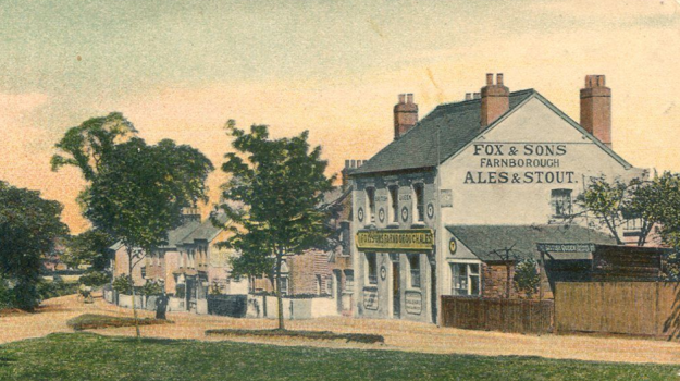
The Fox and Sons ‘ghost sign’ is next door to the Café.  Ghost signs are painted advertising signs, they are not meant to be permanent – although were to last much longer than their modern day counterparts.  The urban landscape used to be full of them but most have been lost – either to modern advertising, being painted over or the buildings themselves being demolished lost.  There are still quite a few locally – the best local ‘collection’ is around Sandhurst Market at the other end of Corbett estate.  They can be

This was very briefly an off licence, there is a photo of it but it didn’t seem to last long enough to make local directories. There is much more on the brewery behind the ghost sign in a post here.

The Pillar Box on the corner of Beacon Road may look ordinary but it was attacked by suffragettes in 1913 – it was one of many similar attacks by Lewisham’s militant WSPU branch. 


St. Swithun’s Church

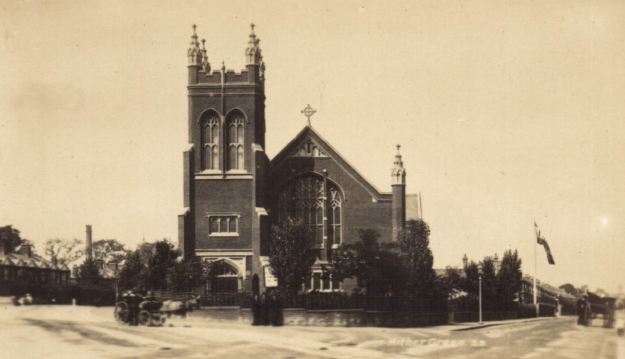
The church building dates from 1904, although the now church hall was used as a church from 1884.  Both were designed by Ernest Newton who also designed the Baring Hall, the original Church of The Good Shepherd and Lochaber Hall.  Gladys Cooper, the actress was baptised here.

Perhaps the biggest surprise with St Swithun’s (pictured above) – is that it is still here.  So many of the local churches were lost in World War Two – the Methodist Church at the junction of Hither Green Lane and Wellmeadow Road, the original church of The Good Shepherd, Christ Church on Lee Park and Holy Trinity on Glenton Road.

Merbury Close

Merbury Close was developed as a sheltered scheme for the elderly in 1986.  Before that it had been a nursery – the last remnant of something that this end of Hither Green had several of  – the best known – run  Lewisham Nursery, run in its later years by Willmott and Chaundy, which finally closed in 1860.

Bullseye or Japes Cottage – (pictured above) was on the corner of Harvard Road and Hither Green Lane – it was the gardener’s cottage for one of the larger houses on Hither Green Lane  – the inappropriately named, in terms of size, Laurel Cottage.

Spotted Cow – one of the older pubs in the area, the name referring to its rural past; it closed around 2007 and was converted into flats by L&Q Housing Trust, the block at the side is the name of one of its former Chairs.

Monument Gardens

From the 1820s to 1940s this was ‘home’ to Camps Hill House, an impressive large house which was built in the 1820s for the brick maker Henry Lee – it is pictured below (source eBay October 2016) .  It was demolished post-war for what initially called the Heather Grove estate.  There is a much fuller history of both the estate and its predecessor in a blog post from 2016.

The monument on the grass is something of a mystery  – it is dated 1721, well before Campshill House was built – it is rumoured to memorial to an animal – it isn’t marked on Victorian Ordnance maps, although seems to have been there from the mid-19th century.

Nightingale Grove

This used to be called Glenview Road and was the location of one of the biggest local losses of life during World War 1 – a large bomb was dropped by a Zeppelin  in the ‘silent’ raid on the night of 19/20 October 1917.   There were 15 deaths, including 10 children, two families were decimated – the Kinsgtons and the Millgates.  The attack was covered in an early post in Running Past, as was its fictional retelling by Henry Williamson, better known for writing ‘Tarka the Otter.’

Hansbury’s (formerly the Sir David Brewster)

When this post was first written this was one of the more depressing sites (or sights) on the walk – a rapidly decaying former pub,.  While it has been converted into flats, the bar remains closed.  It was once one of half a dozen Hither Green boozers, despite Archibald Cameron Corbett preventing them on the former North Park Farm.  Hither Green now has just one pub, the Station Hotel along with the Park Fever beer and chocolate shop opposite on Staplehurst Road which offers some limited seating and the new Bob’s on Hither Green Lane.  A 2016 blog post tells the story of the pub.

There was an attempt to build a pub in the late 1870s in Ennersdale Road, however, there were two rival builders and they seemed to expect the magistrates to decide on which one to allow.  In the end neither happened (1).

Dermody Gardens

The path over the railway to here used to be called Hocum Pocum Lane (covered a while ago in Running Past), it can be followed back to St Mary’s and beyond towards Nunhead and continues down the hill over a long established bridge over the Quaggy and then north along Weardale Road to join Lee High Road by Dirty South (formerly the Rose of Lee).  It was renamed Dermody Road after an alcoholic Irish poet in the 1870s – Thomas Dermody (below) is buried at St Mary’s and there is something on his short life here.

Towards Lewisham the street layout evolved in the early 1870, the area was certainly included within the Lewisham Nursery of Wilmott and Chaundy who grew Wisteria amongst other plants, although the name of the road may predate the nursery.  The area beyond this, towards Lewisham, was developed as the College Park Estate in the 1860s.

The Holly Tree closed in 2017 and, like its neighbour over the railway, while the upper floors are used as flats the doors tot eh bar remain firmly shut.

Manor Park

This was a pig farm before being turned into a park in the 1960s, although it was once of Lewisham’s more neglected parks until a major upgrade in 2007 with Heritage and Environment Agency funding the river was opened up park and the park re-planted to encourage wildlife.   There are Running Past posts on both the Park and the Quaggy at this point.

While going through Manor Park is a pleasant detour – we will only see the backs of the houses of Leaahurst Road.  Large chunks of this end of the street, particularity on the western side were destroyed during World War 2.  The bomb sites were searched extensively during a notorious 1943 child murder investigation – the murderer was Patrick Kingston, a surviving member of the family almost wiped out in the Zeppelin attack.

Leahurst Road was also home to one of Hither Green’s once famous residents – the early Channel swimmer, Hilda ‘Laddie’ Sharp (pictured above).

Staplehurst Road

The Shops were built in the early 20th century, a little later than those in Springbank Road, the dates are marked in several places as one of the original ‘Parades’ – the sign for Station Parade is still there (above the Blue Marlin Fish Bar).  The nature of the shops has changed significantly – although mainly in the period since World War 2.  There is more on this in a blog post, including Hither Green’s Disney store.

The Station Hotel was built by the Dedman family who had previously run both the Old and New Tigers Head pubs at Lee Green and opened around 1907.  It is now Hither Green’s only pub.

The Old Biscuit Factory is a new housing development from around 2013, the site including the building now used by Sainsbury’s was originally a very short-lived cinema, the Globe – which lasted from 1913 until 1915, before being ‘home’ to Chiltonian Biscuits.

The area around Staplehurst Road suffered badly in a World War 1 air raid – two 50 kg and two 100 kg bombs were dropped by German Gotha aircraft and fell close to 187 Leahurst Road, damaging 19 shops and 63 homes, the railway line.  Two soldier lost their lives and six were injured on the evening of 19 May 1918.  Unlike the World War Two attacks, there seems little evidence there now of the bombing.  There was more significant damage and a lot more deaths in Sydenham in the same raid.

World War 2 damage is a little more obvious in Fernhurst Road, there was a small terrace built by the local firm W. J. Scudamore, which was hit by a V-1 rocket in June 1944.  Prefabs were built there immediately after the war, with the present bungalows following in the late 1950s or early 1960s.

If you want to do the walk physically rather than electronically ….

It is about 1.8 miles long and all on footpaths, it seems fine for buggies and wheelchairs apart from one very narrow, steep uneven section on Dermody Road (although it is better on the opposite side of the road).

Toilets – the only ones on the route are in Manor Park, although they are only open when the café is.

Refreshments – several places either side of the station, along with the Café of Good Hope on Hither Green Lane and the Lewisham Arts Café in Manor Park

Public transport (as of May 2018) – there is a bus map here, and rail journey can be planned from here.

Notes

  1. Kentish Mercury 04 October 1879

Picture Credits

  • The postcards and drawing of Campshill House are all from e Bay between January 2015 and January 2018
  • The painting of Japes Cottage is  ©Lewisham Local History and Archives Centre, on a non-commercial licence through Art UK
  • The Ordnance Survey map is on a Creative Commons via the National Library of Scotland
  • The photograph of the destruction of Glenview Road in the ‘silent’ Zeppelin raid is on a Creative Commons via Wikipedia
  • The photograph of the Sir David Brewster (Hansbury’s) is from the information boards at Hither Green Station.
  • The picture of Thomas Dermody comes from an information board at St Mary’s church
  • The photographs of Hilda Sharp – left photo source, right photo Times [London, England] 25 Aug. 1928: 14. The Times Digital Archive

A World War One Childhood in Hither Green

One of the more surprising literary links to Lewisham, and Hither Green in particular, is that of Dora Saint, much better known as ‘Miss Read’ who wrote about the fictional, very rural, hamlets of Thrush Green and Fairacre.  She spent some of her formative years in the then more suburban Hither Green – opposite Park Hospital.

While her gentle, observational novels about seemingly cosy, idyllic and probably idealised bucolic landscapes sold well, particularly abroad, she never featured that strongly in the British public consciousness.  In addition to her novels she wrote a series of short autobiographical volumes, the first of which related to a few years in Hither Green.

‘Miss Read’ was born as Dora Shafe in South Norwood in April 1913, her father was an insurance salesman who was conscripted during the First World War. Her mother kept on his ‘round’ of door to door collections to maintain the family income and the family moved to Hither Green around 1916, where Dora grew up surrounded by a close-knit extended family of aunts and grandparents.

imageThe family home’s location isn’t clear, there was no mention of the family in the Kelly’s Directories of the era (maybe sometime I will trawl through electoral registers…), but much of Dora’s early childhood was spent at the home of her grandmother at 267 Hither Green Lane opposite the then Park Hospital.  The house is still there and the first volume of her autobiography paints an interesting picture of life and growing up in Hither Green during World War 1.

It was relatively well-to-do home, dominated by strong women – her maternal grandmother, Sarah Read, and two unmarried aunts – Jess and Rose.  The latter seems to have lived elsewhere but spend most of her non-working time at 267, probably contributing heavily to the household income.  Dora’s own mother and her uncle who also lived at 267 rarely get a mention.  As the older Dora noted the chief attraction of the house, in retrospect, was the affection with which Dora and her sister were surrounded.’ (1)

image

The House

She describes the house as a solidly built red brick house, it had a vigorous climbing red pyracantha at the front – Aunt Jess would lean out of the front bedroom to cut branches to take to school in the autumn (2);  the red brick is now painted and the pyracantha is long gone though. The house is visible between the trees on postcard above.

image

Whilst it well into the 20th century Sarah Read’s ‘house in Hither Green Lane was a Victorian one, and furnished in the Victorian style, sombre and heavy.’ This was contrasted with her paternal grandmother’s home in Walton on the Naze which reflected the relative ‘gaiety’ of the Edwardian era. (3)

The ‘drawing room’ at the front was Dora’s favourite – recalling plush red upholstered furniture and carpets, conch shells on the mantelpiece, when the fire wasn’t lit there was a beaded screen with arum lilies in front of it (4). There was a piano which had china cherubs perched on top, there was a small octagonal table with a potted fern.

The dining room was reached through rarely opened double doors and was dominated by a large mahogany table and chairs, with a corner cabinet containing the best and specimen china (5).  There was a conservatory at the back where fairy lights in small, different coloured glass jars were once lit (6).

Upstairs, there was an inside toilet and a separate bath with brass taps and encased in wood (7) – having an inside WC made it at the more genteel end of London living. Dora remembered being forced to spend time there to ‘try, dear’ before heading off to school.

Beyond the bathroom was Grandma Read’s room where Dora was meant to sleep in bed in afternoons before she was of school age and then during school holidays ‘tucked up under the eiderdown in just my vest, liberty bodice, chemise, knickers… petticoat and socks.’ (8). However,  she often just investigated the room rather than sleep – heading for the lace mat covered dressing table (9). There was a coloured glazed door from the bedroom through which the young Dora would imagine an underwater world through a blue pane, and a world of winter sun through the crimson glass (10).

Her aunt’s room was at the front of the house, looking out towards the hospital which even then had trees big enough to screen it (11) – perhaps remnants of Wilderness House that was on the site before the hospital.

The house was set up for servants with a set of bells operated by handles next to the fireplaces which rang in the kitchen (12).

Out and About in Hither Green

Grandmother Sarah regularly went to the then new Park cinema, the building is still there on the corner of George Lane, where the films were changed a couple of times a week.  Sometimes she went on her own, sometimes with friends, although there is not mention of the young Dora going too (13).

image


cats-meat-man-x300-m-1482-204x300There was a ‘cats meat man’ with a raucous voice whole sold skewers threaded with cooked horse meat (14) although the young Dora misunderstood the concept and was worried that it was the meat of cats that was being sold from the back of the trap (picture source).


Church, Sunday School and Singing

Sarah, Jess, Rose as well as Dora and her sister, all seemed to go to St Swithun’s Church a little further up Hither Green Lane (15); Rose ran the Sunday school there – ‘simple hymns and prayers alternated with handwork, making Moses in Plasticine, for instance, to put into a carefully woven cradle…There was quite a bit of marching…’ (16).

image

Congregation members often came back to 267 to sing around the piano in the ‘drawing room’.  Dora and more particularly her sister found this quite boring and hid behind the piano amongst the sheet music (17).

It wasn’t just church music though that was sung, Sarah clearly had been to music hall as there was lots of singing of music hall numbers as well as some of the more contemporary wartime songs (18).

Goodbye-ee, Goodbye-ee

Wipe the tea, baby dear,

From your eye-ee!

Wartime Memories

There was little recollection of the war itself other than the difficulties of getting certain foods, although as the youngest, it seems that Sarah spoiled Dora by putting her with sugar in sandwiches for her (19).

Soldiers and sailors regularly turned up at 267 for post church singing during the war (20), but apart from that the only mention was noticing a crater from a bomb one morning after a raid (21).  This was almost certainly in May 1918 when the area was attacked by aircraft, 2 bombs were dropped, one near St Swithun’s Church, where about 20 houses were damaged; the other bomb on Hither Green Lane, damaged 12 houses. No people were injured or killed, and, presumably, the second was some distance from 267, otherwise Dora would have probably recalled it.

The sisters were frightened that the Kaiser was hiding behind curtains on the landing ready to pounce! (22)

School

Their aunt, Rose, was a teacher at Ennersdale Road (now Trinity) School (23) and took both Dora and her elder sister to school with her. Dora’s first visit was the day before her fourth birthday in 1917 (24) her sister was already there.

The route to school involved walking down Ennersdale Road, the rumbling of the trains overhead terrified the young Dora (25).

image

At Play

Dora played a lot in the kitchen, often with her Aunt Jess, whilst she iron or made clothes.  She modelled with plasticine – mimicking the grocer cutting and wrapping up butter from the marble slab at the Home and Colonial Stores (26), which were at 180 Hither Green Lane, between Lanier and Theodore Roads (the picture is illustrative rather than Hither Green Lane – Creative Commons source here)

home_and_colonial_stores_may_10_1910

Other shopping games were played in the kitchen too, whilst most of the ‘purchases’ were imaginary, a request for ‘a farthing’s worth of currants’ would often lead to the real thing being brought down from a large metal canister on a high shelf (27).

The early books that the young Dora had read to her at 267 included many of the Beatrix Potter, which had begun to be published at the turn of the century (28).

Dora and her family moved out to the more rural Chelsfield soon after the war ended – both she and her mother were seriously ill as a result of the Spanish Flu epidemic of 1918 to 1921 – and they moved for the country ‘air’ whilst her father continued to work as an insurance salesman.

Notes

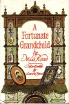
  1. ‘Miss Read’ (1982) A Fortunate Grandchild (Boston, Houghton Mifflin), p58
  2. Ibid p48
  3. ibid p101
  4. ibid p48
  5. ibid p50
  6. ibid p51
  7. ibid p51
  8. ibid p52
  9. ibid p53
  10. ibid p55
  11. ibid p56
  12. ibid p57
  13. ibid p15
  14. ibid p38
  15. ibid p15
  16. ibid p35
  17. ibid p16
  18. ibid p18
  19. ibid p19
  20. ibid p19
  21. ibid p40
  22. ibid p47
  23. ibid p29
  24. ibid p31
  25. ibid p39
  26. ibid p19
  27. ibid p28
  28. ibid p28

The postcards are all from eBay, downloaded during 2015 and 2016.

North Park – The Farm Before the Corbett Estate

There has probably never been a single sale of land around Hither Green and Lee that has been more significant than the sale of North Park Farm by the Earl of St Germans in 1895 as it allowed for the development of was was initially known as the St Germans estate, now generally known as the Corbett estate. We will return to the development sometime later, but for now we will look at the farm itself.

The name of North Park Farm goes back to at least the mid 16th century (1); while it is possible that the location changed over the next century it was clear on John Roque’s 1745 map – the easterly buildings in ‘Hether Green.’

image

It was situated on what is now Duncrievie Road – it remained in that area until the sale. Initially it was a relatively small farm, around 65 – 75 acres (2).  For a while it seems to have been known as Plum Farm – there is a reference to it as this on at least one map.

There had been a South Park Farm too – a small farm of around 70 acres centred around Dowanhill and Hazelbank Roads, which later ‘moved’ to somewhere around the Torridon and Brownhill Roads junction (3). The South Park name lives on in a street, South Park Crescent to the east of Verdant Lane.  The farm was renamed ‘Longmisery’ in the early 19th century but seems to have been merged with North Park Farm by the middle of that century (4) along with part of Rushey Green Farm by 1838 and a former nursery, Butlers Gardens, around 1860 (5). The latter nursery of around 43 acres was run by Willmot and Co, later Willmot and Chaundy – referred to in relation to Hocum Pocum Lane.

By this stage the farm was being had been run by the Owens for a generation and a half; there is reference to Abraham Owen in the 1843 Tithe Awards farming 201 acres, including around 38 acres of pasture and the remaining arable. He also farmed another 40 acres, elsewhere in Lewisham from landowners other than the St Germans, including church lands.

Owen also ran a butcher’s shop which was located at what is now 304 Lewisham High Street, almost opposite the current fire station. The family also had another shop a little further north, at Lee Bridge (the bottom of Lee High Road) – Abraham’s son is reported as having rescued a boy who fell into a flooded River Quaggy in 1844.

While a tenant farmer, Owen seems to have been a man of influence – his name appears in the 1838 list of Land Tax Commissioners for Lewisham – generally ‘commissioners were drawn from the gentry, but also included members of the peerage and of the professions, such as doctors. They were not paid for the work they did.’

In addition to the farming and the butchers, Owen (and his father Edward before him) acted as an auctioneer – amongst many other farm sales, he undertook the sale of the lease of Horn Park Farm in 1822, which William Morris(s) seems to have been the successful bidder for (6).

Abraham Owen died in 1845 which probably triggered the disposal of the lease to the farm, his will described him as a farmer and butcher.

The last farmers of North Park were the Sheppards – brothers Edward and Samuel. The family had an early mention in 1823 when they were farming land that was included in a diversion of a footpath from Loampit Vale to what is now Brockley Road.  The Samuel referred to would have been their father, as the two brothers would have been children then, Samuel was born in 1819 and Edward in 1814, both in Deptford. According to the 1841 census, the farm was Ravensbourne Farm – Samuel (Senior) had been born in 1781 and there were four adult children living on the farm. The oldest brother, Henry took over Ravensbourne Farm, after his father had died – Edward was still there in 1851.

While the brothers took over the farm in 1849 (7) they didn’t move in until later. The farm was managed for them by William Fry, who may have worked for the Owens just before the Sheppards took over, as his three youngest children in the 1851 census were born in Lewisham – the oldest of them born in 1848. Fry originated from Brasted in Kent, but had been working for a decade in Erith. Fry was to continue working for the Sheppards – he was still on the farm, in The Cottage, probably the original farm in 1861 – one of the buildings at the eastern side of the farm on the upper map below. His wife, Sarah, had 10 children by then.

image

By 1861, Edward had married Jemima and they were living at the new farm house which had been built in the mid 1850s, and was located about half way up Duncrievie Road (just to the west of the farm buildings on the upper map). The the census says he had ‘250 acres, 16 men and 4 boys’ – several of these would have been William Fry and his family members. Jemima died in 1876 (8), there seems to be not reference to them in the 1871 census, but the farm and employment had shrunk to 200 acres and 10 men in 1881. By 1891, he was listed as a retired farmer although still living on the farm, he suffered from mental health problems in his later years and needed an ‘attendant’ to help him cope; Edward died in 1892, before the farm was sold.

Fry was still there in 1871 at what was described as North Park Farm in the census. By 1881 though, he was living with his son who was a ‘fly proprietor’ on Lewisham High Street. A ‘fly’ was a one horse, two wheeled carriage, in case you wondered… Fry’s wife Sarah had died in 1871, with William passing away in 1888.

As for Samuel, he had married Emma in 1849 although there is no census record for them in 1851 – they may have been at Burnt Ash Farm which he had a brief interest in. In 1861 he was working as a market gardener, still around Deptford – their address was 7 Market Garden. Samuel and his family moved to the North Park farm in the 1860s, Eliot House (sometimes called Lodge) was built around 1867 for him. It still remains on the corner of Duncrievie Road and Hither Green Lane (the westerly of the highlights on the lower map).

image
The 1871 census shows that Samuel and Emma had six children who had all been born in Deptford, the eldest son also Samuel, was to take over Bellingham Farm. By 1881, little had changed other than the eldest daughter, also Emma, had moved out. Samuel (1819) was to live until 1904, remaining at Eliot House.

A lot of wheat was grown on the farm, a newspaper report noted in 1868 that there were much higher yields at North Park Farm than in neighbouring farms (9). Latterly though, with the growth of London the wheat will have almost certainly given way to market gardening.

Small parcels of land on the edge of the farm had been sold off to speculative builders almost two decades before the final sale of the farm, they were hoping for Hither Green junction to become a station – these were to become Brightside (developed from 1878), Elthruda (1882) and Mallet Roads (1882) (10). Mallet was the author of a masque about Alfred the Great which contained ‘Rule, Britannia!’ It was written in 1740 but there is no obvious link with Lewisham.
image

Other than the farm house, the only other obvious remains of the farm are a trio of farm workers cottages which are now 387 and 389 Hither Green Lane, at the junction with Springbank Road (11). They were referred to as Sheppard’s Cottages, for around a decade after the sale of the farm in Kellys Directories.

Notes
1 Godfrey Smith (1997) ‘Hither Green: The Forgotten Hamlet’ p10
2 ibid p11
3 ibid p 12
4 ibid p12
5 ibid p11
6 The Morning Post (London, England), Saturday, June 01, 1822 p1
7 Smith op cit p11
8 Daily News (London, England), Monday, August 28, 1876; Issue 9469.
9 The Times (London, England), Thursday, Aug 13, 1868; pg. 9; Issue 26202
10 All the development dates come from Joan Read (1990) ‘Lewisham Street Names & Their Origins (Before 1965)’
11 Smith op cit p11

Census and related data comes from Find My Past, references to Kelly’s Directories come from Leicester University and the Ordnance Survey maps are from the National Library of Scotland on a creative commons

A Hither Green Ghost Sign of a Long ‘Lost’ Brewery

In the middle of a row of shops on Hither Green Lane is a single-storey building, which seems oddly out of place in the two/three storey late Victorian properties – it has created some advertising space which remains filled by a painted ‘ghost sign’ which, at its very latest was painted in 1909 – more on that later.  The single-storey building may have originally been the same size as the rest of the terrace, the building was destroyed in a fire in 1894 (1).

image

The sign has clearly gone through at least two incarnations, painted over the top of each other, and have unevenly weathered, it appears to read – ‘Fox & Sons’. Below that is ‘…nborough’, then ‘Ales Stout’ and finally ‘In bottle and cask’.  There looks to be ‘wine’ in the midst too.

image

It is quite common for ‘ghost signs’ to relate to the business on the side of the building that it was painted on – Running Past has covered several including John Campion & Sons in Catford, a bakers in Sandhurst Road, Catford, a now hidden one at Lee Green and perhaps my favourite Wallace Prings Chemists in Bromley.

Fox & Sons were brewers from Green Street Green in Farnborough, now on the edge of Bromley. In the period up until the end of World War 1, and probably much longer, 210 Hither Green Lane seems to have been one of a pair of butchers shops on Hither Green Lane run by Joseph Hurdidge.  Hurdidge was born in Old Ford in 1865 and seems to have taken over the (presumably) tenancy of the 132 Hither Green Lane around 1890 and probably expanded to 210 when the shops were developed a little later.  Hurdidge certainly remained in the trade and remained in the Lewisham area for the rest of his life – in the 1939 Register he was still working but widowed and living at 78 Eltham Road, Lee, where he died in 1952.

There were a couple of off licences on Hither Green Lane – one just to the north of Harvard Road, run for years by a Robert Mott and one adjacent to Woodlands Street run by Florence Jackson.  Neither was mentioned in the sign though, although they may have sold bottled Fox and Co beer. More likely though is that there was a very short-lived off licence in the single story building next door – there is a photo of it but it didn’t seem to last long enough to make local directories.

Like most modern advertising billboards, it seems to have been a more general sign which the Brewery probably repeated in many locations – there is a postcard of a still serving pub from around 1906, the British Queen in Locksbottom, with an identical advertisement on the building side.

Source eBay April 2016

Source eBay April 2016

So what of the brewery? John Fox (born around 1787 in Buckinghamshire) had moved to Green Street Green in 1818 to run Oak Farm.  He brewed a little for himself and his employees but decided to set up a proper brewery on the site in the 1830s.  The business was taken over by his son Thomas (born 1819) who was still running the brewery (pictured below) with his sons in the 1881 census, but died in 1886. The third generation, Thomas (born 1852) and Walter St John Fox (born 1855), took full control after their father’s death.

fox-1

Source here

By the mid 1860s they had three main beers – BB Bitter, which they sold at £2 a barrel, XL Pale Ale at £2.25, and East India Pale Ale for £2.50 cash price.   All had been “carefully brewed from malt of the finest quality and they are hopped with the best Kent growths.”  They delivered to most of the then rural suburbs of south east London – including Lee and Lewisham every Thursday.  By 1891 the Oak Brewery was attempting to mimic the Burton Pale Ales and treated the water with gypsum, quarried by the River Trent to try to do this.

By 1909 they had expanded their range of beer – the best known was Farnborough Ale (FA) – which they described as ‘bright, sparking and nutritious.’ They had almost 40 tied public houses and employed 110 workers in brewing, distribution as well as associated trades such as barrel making and a blacksmith.  The brewery was the centre of village life in Green Street Green, with around 30 tied cottages.

Early in the 20th century, the brothers may have been in some financial problems – they were certainly re-mortgaging some of the ‘tied houses’ in 1906.  The partnership was dissolved in 1907 and they decided to retire, putting the brewery put up for sale including its ‘tied houses.’ (2 – see cutting below).

fox-2

It was not a good time to sell – values in the brewing industry were falling sharply (3), the 1904 Licensing Act gave magistrates more powers to refuse licences, particularly if there were a number of pubs in the area, although the value of the smaller number licences was expected to increase (4).

The Oak Brewery was bought in June 1907 for £89,000 (5); but the new owners clearly struggled and there was a second auction in April 1908 (6), but with a ‘reserve’ of £60,000 it failed to attract any interest.  It was split into smaller lots in June 1909 (7 – see below) with other breweries buying up the tied houses.  As brewing stopped in July 1909, presumably there was a separate sale of the buildings which were put to a variety of other uses after 1909 including military uses in the First World War and a later a plastic factory. The buildings were demolished for housing in the 1960s.

fox-3

Notes

  1. The Times (London, England), Monday, Dec 10, 1894; pg. 10; Issue 34443.
  2. The Times (London, England), Saturday, May 18, 1907; pg. 20; Issue 38336.
  3. The Times (London, England), Saturday, Dec 28, 1907; pg. 13; Issue 38528.
  4. Ibid
  5. The Times (London, England), Saturday, Jun 19, 1909; pg. 15; Issue 38990.
  6. Ibid
  7. ibid

Census and related information comes from Find My Past

Kelly’s Directory data is from the Collection at Leicester University


Campshill House – Housing for the Victorian Elite & the Post War Working Classes

Campshill was one of the larger houses on Hither Green Lane – it was home for a few generations to some of the wealthy of Victorian society. It declined during the 20th century being demolished to make way for post-war council housing.  It was built in the mid-1820s after Henry Lee had leased the land from Trinity College and built Campshill House. Henry was a brick maker and lime merchant who had previously lived with his brother, Henry, at Ellerslie House, close to their works on Loampit Vale.

campshillh

The Lee family were to remain at Campshill (above – source eBay October 2016) until around 1858, after both Henry and his widow had died, the latter in 1849 (1).

One of the next inhabitants was James Allan who bought the House in 1861.  He was an Aberdonian, born in 1811, he had worked for a variety of Scottish shipping based employers before moving to London with one of these which was to become the Peninsular Steam Navigation Company, later the Peninsular and Oriental Company (P & O).  He was to become Secretary, then Managing Director in 1848 – a position he held until his death in 1874.

Allen’s career was described as

one of steady industry and intelligent supervision. Without marked energy either of intellect or of action, his progress was rendered sure by the wisdom of his judgments, which were singularly undisturbed by any emotion of interest or of temper, and by his amiability of character, which disarmed hostility.

While the area was predominantly rural in feel when Allan bought Campshill House – the map below was surveyed in the 1860s

Campshill1

The lease for the house was put up for sale in 1879, with an advertisement in The Times describing it as a ‘capital family residence’ (2)

Campshill2

The purchaser may have been a W. H. Smith who lived at the House in the 1880s and 1890s, he wasn’t connected to the eponymous booksellers; the son of the founder of the stationers lived in altogether more grand Grosvenor Place, but may have known Campshill’s W. H. Smith, as both were members of the London Library.

Campshill’s W. H. Smith seems to have owned a firm of Gibraltar based shipping agents, Smith Imossi and Co, which still is in existence.

In the early inter-war years the Campshill House, was home to a glass bottle merchant and then a garage.   By 1927 it was home to Henry Thomas Taylor and John Belmont Taylor; the latter was a surveyor, he was in partnership with Horace William Langdon but their partnership was dissolved in 1927.  The quantity surveying firm he left behind was to become internationally successful; continuing today as Langdon & Seah.

Henry Thomas Taylor, who was almost certainly John Belmont’s his uncle.  Henry Thomas Taylor had been one of the brothers who had developed the Edwardian estates of Belmont Hill and Park Langley. The other brother was John, John Belmont’s father.  Presumably, the Belmont middle name was a reference to the Lewisham estate that was being developed at the time of his birth.

They bought sites in Langley Way on the Hayes/West Wickham borders in 1929 and The Crescent, Hayes, in 1932 and 1933. By the latter purchase, Henry seems to have moved back to the Beckenham area.

The name had changed to ‘Canada House’ by 1929 – the name is thought to refer to the billeting of Canadian troops at the House during World War 1.

It seems likely that Taylor was the last occupant of the House.  According to the Lewisham Air Raid Precautions (ARP) log, it was hit by a V1 rocket at 01:39 on 27 July 1944 – the rocket was listed as hitting ‘Hither Green Lane between Thornford Road and Ryecroft Road.’ There were no deaths, but three were injured and there was a fire. While the log noted that the fire was brought ‘under control,’ it wasn’t enough to save the building.

The London County Council Bomb Damage Maps 1939-1945 (3), shades the main house as a dark blue, one step better than ‘completely destroyed’ and outbuildings in purple, ‘damaged beyond repair.’ Given the amount of land that was still attached to the House it is not surprising that the grounds were quickly used for housing after World War 2.

As we have seen with other posts, there were two routes to replacement housing after World War 2 – the temporary and the permanent. The first was the result of post-war brick shortages meant that non traditional prefab bungalows were built in the parkland of Forster Memorial Park (Excalibur estate), Hillyfields and Hollyhedge Bungalows on Blackheath along with some smaller sites whether there had been large scale rocket destruction, such as Lenham Road,and Fernbrook Road  what is now the Mercator estate. The second group saw permanent homes constructed quickly and included Passfields on Bromley Road, Lewisham Hill and the Flower House estate. The cleared land from Camps Hill House was in this second category.

Campshill3

In any case the area had changed since the time of the Allans and Lees; as outlined in the post on ‘Hocum Pocum Lane’ which skirted the edge of the estate, the former market gardening area around Eastdown Park had been developed from the 1870s and the arrival of a station at Hither Green junction in 1895 saw the rest of the area developed.  Victorian terraced houses and the early council housing of Romborough Way and Campshill Road surrounded it.

146 homes were built where there had been built where there had been one, on what was initially referred to as the Heather (or Hether) Grove Estate. The picture below (3) seems to be the block that faced onto Hither Green Lane.  The builder was A Roberts, a firm that seemed to specialise in medium sized public sector projects such as this.

Campshill4
The architect for the development was  M. H. Forward, who was Lewisham’s Borough Architect, a position he held at least until 1962/63.  The the architects model which displayed at an exhibition at the Town Hall in 1950.

M H Forward was later responsible for the rather out of keeping additions to the side of Sydenham Library. In the intervening period he started the redevelopment of the old Lewisham Town Hall site which was eventually completed by his successor in 1968. The estate did have a few attractive touches like the archway that was part of Southfield House which faced onto Thornford Road.

The Heather Grove Estate was opened by the Lewisham MP, Herbert Morrison in 1948 – there is video footage of the opening with the then Deputy Prime Minister unveiling a commemoration stone and going inside the flats – sadly it isn’t publicly available.

While the new homes were built to a high standard, there were issues of affordability, something that has echoes in present new social housing, which have Orwellian ‘affordable’ rents.  It was noted by the Tory MP for Lewisham West, Henry Price in a Parliamentary debate in 1950

The rents here are 36/- (£1.80) a week, and for a four-bedroomed flat 39/- (£1.95) despite a subsidy of about 27/- (£1.35) per week. The result was that of the first 80 people to whom these flats were offered more than 40 had to refuse them because they could not afford to pay the rent. The flats had to be let to families a little lower down the list whose need was not so great but whose pockets were a little deeper.

image

Nothing remains of the former Campshill House, however, one feature escaped the post war wrecking ball – an obelisk remains on the grassed area to the east of what is now referred to as Benden House.  There is no inscription other than a date, 1721, but it is thought to be a memorial to an animal, (possibly a horse). The date is a century earlier than the former house, so whether it was on the site before the House or was a family monument that was subsequently moved to the site by a previous occupant is unclear.

image

The estate was not one that stood the test of time, while the two blocks at the rear of the estate remain, including Benden House, the blocks facing Hither Green Lane and Thornford Road was demolished in the 1980s  and replaced with attractive council houses – Canada Gardens (echoing the latter name of Campshill House) facing Hither Green Lane and Kemp’s Gardens off Thornhill Road which comes from an earlier name for the area – Kemp’s Hill.


Notes

  1. The Standard (London, England), Saturday, April 21, 1849; Issue 7703
  2. The Times (London, England), Saturday, Jul 05, 1879; pg. 18; Issue 29612
  3. Lawrence Ward (2015) ‘The London County Council Bomb Damage Maps’ p184

Picture Credits

  • The drawing of Camps Hill was from e Bay in January 2017
  • The Ordnance Survey maps are from the collection of the National Library of Scotland on a non-commercial licence
  • Teh photogrpah of the block on Hither Green Lane was from e Bay in May 2016
  • The photographs of the architects model and the arch at Southfields House are part of the collection of Lewisham Archives, they remain their copyright and are used here with permission.

Bullseye Cottage of Hither Green Lane

One of the stranger looking houses in Victorian Hither Green was Bullseye Cottage which stood on what is now the corner of Harvard Road and Hither Green Lane.  The Bullseye name came from its rather distinctive circular windows. It was latterly known as Japes Cottage after its final inhabitant, William Japes.

unknown artist; Jape's Cottage, Hither Green Lane

See note on painting at end

There is a surviving painting of the cottage by an unknown artist dates from around 1860 and is looking roughly south-west – Crystal Palace (and its adjacent water tower), moved to Anerley Hill in 1854 is visible across the largely open countryside.

William Japes was gardener at Laurel Cottage, see below (source), which was a large house around 200 metres further south along Hither Green Lane , almost opposite Mountsfield Close, between Lanier and Theodore Roads.

japes cottage3

Laurel Cottage dated back until at least the early 19th century, it was advertised for letting in 1835 (1), and described as a ‘detached‘ Gothic Villa’.  Great play was made of one of its previous occupants having been Sir John McMahon, who was ‘Keeper of the Privy Purse’ from 1812 until his death in 1817.  The ‘gardener’s cottage’ mentioned was presumably Bullseye Cottage.

japes cottage2

William Japes hailed from Cambridgeshire – seemingly from Willingham, a village mid-way between Cambridge and Huntingdon.  He married Louisa from Lewisham around 1832 so he must have moved to the area before then.  Whether he was already working at Laurel Cottage at that stage is unclear; the first reference to him at Bullseye Cottage was in the 1851 census – in addition to Louisa, the were five children living there, along with a visitor.

While the children moved on from Bullseye Cottage, William and Louisa seem to have remained – they were still as living on Hither Green Lane in 1871, although the house wasn’t given a name or number.  William was still listed as a gardener in the census (no mention of ‘retired’), although they had a couple of lodgers living there too.  Development was afoot though Harvard Road seems to have been laid out around 1871 (2).

image

William died in Lewisham in 1874 and if Bullseye Cottage was still there at that stage, it seems that the cottage was demolished soon after to make way for the shop fronts now there.  As for Laurel Cottage, that survived around another 20 years or so until it too succumbed to urbanisation, Theodore Road dates from 1897 (3).  The shop fronts below are on its former site.

image

Little can be found of Laurel Cottage’s occupants other than there was a steady flow of inhabitants noted by the deaths, marriages, auctions and servant advertisements reported in the press.  As late as 1883 there were some elements of farming going on from the land associated with the ‘cottage’ – the auction particulars included  an Alderney cow and several head of chicken (4).  The marriage of the younger daughter of a W J Seward warranted an advertisement in The Times in 1887 (5).

Laurel Cottage seems to have been renamed as The Laurels in the early 1890s; its last inhabitant was probably the then renowned mathematician William Burnside, an academic at the Royal Naval Cottage.

Notes

  1. The Morning Post (London, England), Wednesday, March 25, 1835; pg. [1]; Issue 20061
  2. Joan Read (1990) ‘Lewisham Street Names & Their Origins’, p26
  3. Ibid p54
  4. The Times (London, England), Friday, Mar 23, 1883; pg. 12; Issue 30775.
  5. The Times (London, England), Thursday, Oct 06, 1887; pg. 1; Issue 32196.

Picture Credit

The painting is owned by Lewisham Archives and made available on the Art UK website, reproduction is allowed for the non-commercial research purposes, such as this post.

The census and related data, other than where ‘linked’ comes from Find My Past.


The Lost Methodist Church of Hither Green Lane

The Church had an impressive position on the angle of Wellmeadow Road and Hither Green Lane and was part of the St Germans Estate, now generally known as the Corbett Estate, it was one of seven places of worship built on the Estate – although there were no public houses or off-licences.

Source EBay February 2016

Source – EBay February 2016

The foundation stone was laid in July 1899 and completed the following year at a cost of £4,800, and accommodated 700 worshipers.  The building work was carried out by C. Castle & Son of Lower Clapton, little is known of them other than it was may well have been the son, Frederick William Castle, who was carrying out the work.  The firm went ‘bust’ in 1911 when Frederick was living in Alcester Crescent in Lower Clapton trading out of Milton Works Shacklewell Lane in Hackney.

The church has been described as being of

red brick with stone dressings in the 16th century Gothic style with heavily traceried windows and a tall pinnacled tower. The interior consisted of a nave, two aisles, a transept, chancel, organ chamber and galleries on three sides.

Its architect was Josiah Gunton was born in the tiny Fens village of Manea, about 4 miles north west of Ely in 1862. In the 1871 census he was 9 and living with an elder brother, William, and his father, also Josiah who was a farmer.  His mother died just before the census was carried out.

In the 1881 census, he was lodging with the Collard family in St Phillips Road in Hackney and was listed as an Architectural Assistant.  He isn’t recorded in either the 1891 or 1901 censuses but married Jessie Runchman from Hackney in 1886, it was probably his second marriage as both his children pre-dated the marriage and his staunch Wesleyan Methodist views would have no doubt ‘prevented’ having children outside wedlock.  They probably stayed around East London – he was captain of Walthamstow Cricket club in in the late 1880s.

By 1911 he and Jessie were  living at 23 Orchard Road in Bromley  and had  two children still at home who had been born in Hackney two decades before, and  along with 3 servants.

Josiah Gunton was articled to the firm Gordon & Lowther and was taken into partnership in 1885. After the death of Lowther in 1900, the practice continued as Gordon & Gunton. William Henry Gunton, Josiah’s son who had been born in 1881 joined as partner in 1916.  Josiah Gunton designed many Wesleyan chapels but the firm Gunton & Gunton tended to specialise in commercial buildings after World War I.

Gunton was a City of London Alderman, having initially been elected for Coleman ward in 1904.  He was a member of the London County Council for the Municipal Reform Party (allied to Conservatives) from 1928 until his sudden death on 5 March 1930 at Hotel Metropole, Monte Carlo, Monaco. There were suggestions that but for his death he might have been elected as Lord Mayor.

The church was destroyed during a raid on the night of 11 September 1940, which also caused a fire a few hundred metres up the road at the Park (later Hither Green) Hospital.

It is not clear why some local churches destroyed in WW2 were rebuilt, such as the Good Shepherd in Lee, but others such as Holy Trinity in Glenton Road and Christ Church in Lee Park weren’t – the latter two have both already been covered in Running Past.  Hither Green Methodist church was one of those that were never rebuilt.  The congregation seems to have largely moved to another Methodist church on the Corbett Estate – what was then known as the Benson Memorial Church on Torridon Road.

The site of the church was redeveloped for council housing after World War Two which is known as Littlebourne – while they are flats that, from the outside at least, have stood the test of time well, and been on the site much longer than the church, they are perhaps not quite so impressive looking.

image

The Benson Memorial Church suffered bomb damage in 1944, possibly as a result of a V1 attack on 4 August which hit Arngask Road, which was opposite the church,although it was initially reported as hitting Torridon Road.  The congregation had to move into the neighbouring church hall.  The Benson Memorial Church eventually became known as Hither Green Methodist Church and remained in the church until 1995 when it was sold for housing.  The hall was modified and refurbished as both a hall and church in 1996.

Note

All the census and related data came via Find My Past 


Hither Green and the Black Death

Romborough Way is a road that it would be easy to pass by without a second thought but it is a name with some interesting history spanning 700 years.

The most recent part of that history is that Romborough Way, along with Campshill Road, formed Lewisham’s first council estate in the 1920s on the site of Campshill House.

20140711-224148-81708244.jpg
What is now Hither Green Lane has existed as a road for hundreds of years following part of the watershed between the river valleys of the Quaggy and the Ravensbourne. There are 14th century accounts of the road going from an earlier incarnation of St Mary’s Church to a hamlet called Rumbergh.

Rumbergh or Romborough was centred around the junction of Hither Green Lane and George Lane. While there are a number of references to the settlement up to 1349 there are none after, leading to the strong likelihood that the inhabitants of the hamlet were some of the victims of the Black Death epidemic that devastated the English population between 1348 and 1350 wiping out 1.5 million out of an estimated population of 4 million.

Along with the more obvious buboes, one of the symptoms of the Black Death was an acute fever – it therefore somewhat ironic that on the site of Romborough, the Park Fever Hospital, later Hither Green Hospital, was built in 1897 following a London-wide Scarlet Fever epidemic in 1893.

20140711-224251-81771363.jpg