Tag Archives: Prefabs

Corona Road – The History of a Lee Street

The word ‘Corona’ with the suffix of ‘virus’ is currently striking fear into the population of much of the world.  In a leafier part of Lee, just off Burnt Ash Hill, there is a street with the name which pre-dates the virus by 140 years and has a much more benign meaning – ‘something suggesting a crown.’  This post looks at some of the history of the street and the neighbouring area.

The land to the east of Burnt Ash Hill in Lee had been probably been in the ownership of the Crown since 1305 as part of the estate of the Eltham Palace which was originally used for hunting.  The area has been covered several times by Running Past in relation to two of the farms on the land, Horn Park and Melrose Farms, as well is in passing in relation to pubs linked to John Pound – including The Crown.

As the city expanded with coming of the railways, they arrived in Lee 1866, the Crown began to sell off fields for housing and related activities.  One of these sales was land for a brick works on the corner of Burnt Ash Hill and what would become Winn Road – a hundred metres or so down the road from another of Lee’s farms, College Farm.  By the 1850s these were, at least partially, owned by John Pound – one of the more significant builders of the Northbrook estate (generally to the west of Burnt Ash Road and Hill) who, as mentioned, also built a quartet of pubs plus a public hall for popular entertainment.

It appears that the brick works was bought by William Winn by 1874 as he had made an application soon after to build what was to become The Crown pub (above) on land which was formerly part of the brick works; in the application he was described as a lighterman and barge owner living at 16 St Stephen’s Road in Bow (1).  Despite being married to Elizabeth, he was living there separately as a lodger, something that was still the case in 1881.   There was another William Winn who was the bailiff at Burnt Ash Farm in the 1850s and early 1860s of a similar age both from East London; however, unless William Winn had two families, it wasn’t him.

In addition to Corona Road, the roads developed by Winn were the eponymous Winn Road and Guibal Road, along with some houses on the eastern side of Burnt Ash Hill.  The early press reports for what was initially called the Burnt Ash Hill Estate are silent on the builder.  However, William Baker who was based at 43 Ronver Road in the 1881 census and employing 12 men, was mentioned in the second phase of the development of the street applying for permission to build 5 homes on the north (2) and 5 on the south side of Corona Road.  So it is quite possible that he built the entire estate.  The houses were substantial ones at the edge of Victorian suburbia – beyond and to the back was rural Kent – as the Ordnance Survey map from 1897 shows.

While the Board of works provided four gas street lights in 1881 (3), it wasn’t until 1889 that they adopted the street and planted lime trees (4); the Board had previously refused to do this, despite complaints from residents, until the builder brought it up to an acceptable standard (5).

It isn’t known how much the houses were sold for but the annual rent was 55 Guineas (£55.25) in 1882, applications could be made at 15 Corona Road which was perhaps being used as a show house for the second phase of houses (6).  This house, now numbered 61, is the only remaining one from the 1880s – it is the left of the two above..

Four years later number 5 was for rent and was described as (7) being in a

Rural situation, on high ground with bracing air.  Near station, shops and tennis ground. Kent £60

The tennis ground was in the apex of Corona Road and Guibal Road and was probably lost in the 1930s as the southern section of Woodyates Road was developed – it isn’t clear whether this was part of the same development as the northern part of the road which was covered a while ago in Running Past.

So who lived there?  A few of the houses were occupied and sold or rented out by the time the census enumerators called in 1881 – in Corona Road itself, only 9 was let or sold, it was home to the Powells – Harry was a senior Civil Servant.  Several on the wider Burnt Ash Hill Estate were the temporary homes to those working for the builders.  Archibald Harrison who was living in one of the houses on Corona Road ‘Burgoyne Cottage;’ he was described as ‘Builder and Decorator, Master’ in the census – it is possible that he may have built some of the estate, or have been a subcontractor for William Baker.

Next to The Crown, on the corner of Corona Road, at Corona Villa, was Elizabeth Winn the seemingly estranged wife of William, their two adult children including William (born 1859) and three servants.  It is worth pausing on the middle one of these, which given the issues that have brought the street name to the fore in 2020, her name seems depressingly apt – Mary Le Fever (see above).  This is almost certainly an enumerator mangling the relatively common French name for an ironworker or smith – Lefèvre.

By the time the census enumerators called again in 1891 Corona Road was an established community. Archibald Harrison, the builder and decorator was still there. The rest of the street clearly oozed wealth an included several were living on their own means, with inherited wealth or had retired with a sizeable income; there was an East India Merchant, a Shipowner and broker, an Accountant, a Civil Engineer and a Chemical Manufacturer. Virtually all had servants, most had more than one.  Elizabeth Winn was still thereon the corner of the street but marked as a widow, with her daughter Maria who was also a widow.

A decade later Archibald Harrison remained and the ‘class’ of occupant was much the same and included a grain merchant, a confectioner, a hardware merchant, a wholesale bookseller, a couple of living on their own means, a shopkeeper, a retired engineer, a solicitor and an accountant. There was also a Mantle manufacturer, George Smith, perhaps the supplier for Alexander Aitken’s shop next to the Lee Green fire station. Again virtually all had servants.

By 1911, not that much had changed, the households were still relatively small in the large houses, almost all with a servant – amongst the occupants was still George Smith, his neighbours included a retired builder, an artist (living on her own means), another living on own means, a ship broker, a company secretary, a bookseller, and a bank cashier.

The 1939 Register was compiled soon after war broke out. A lot had changed since the 1911 census, only one, quite old household had a servant and the household incomes sources and occupations had changed dramatically – jobs now included a teacher, a municipal accountant, office maintenance worker

Corona Road, more particularly the northern side of it fared badly in World War 2, the London County Council maps show much of that side destroyed or damaged beyond repair (8). By 1948 when the Ordnance Survey surveyors mapped the post war urban landscape, that side of the road was full prefab bungalows, no doubt not dissimilar to those that are still present (spring 2020) on the Excalibur Estate a mile to the west.

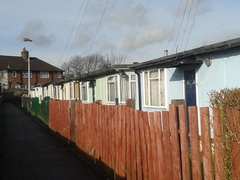
From the exterior of the current blocks and houses the prefabs were probably replaced in the late 1950s or early 1960s by Lewisham Council.

On the opposite side of the road while the bomb damage maps had marked the land as less badly damaged, the site seems to have been cleared by 1948.  This was presumably for the blocks of Elwyn Gardens, which look as though they may have been built soon after the war.

The housing at the western end of Corona Road is newer, perhaps from the early 1980s, following the demolition on the houses facing Burnt Ash Hill.  Like the rest of the estate, where homes have not been sold under right to buy, it is now owned and managed by a housing association L&Q.

Either side of the only house from the 1880s (pictured above), there are a few what look like 1930s houses, but almost certainly date from the 1950s given the wartime destruction.

Notes

  1. Kentish Mercury – 29 August 1874
  2. Woolwich Gazette – 02 October 1880
  3. Kentish Independent – 10 December 1881
  4. Woolwich Gazette -27 September 1889
  5. Kentish Independent -13 November 1886
  6. 22 September 1882 – Kentish Mercury
  7. 26 February 1886 – London Daily News
  8. Laurence Ward(2015) ‘The London County Council Bomb Damage Maps 1939-1945’


Credits

  • A massive thank you to Pat Chappelle who made the link of Corona Road to the correct William Winn – any subsequent errors are, of course, mine.
  • The 1881 census image is via Find My Past as are all the other census, 1939 Register and related references – subscription required
  • The Ordnance Survey maps from 1897 and 1948 are via the National Library of Scotland on a Non-Commercial Licence

The Hither Green Station V-1 Attack

Running Past has covered several of the almost two hundred V-1 and V-2 rocket attacks on Lewisham, including the ones on Lewisham High Street, Lewisham Hill, Lenham Road, Mercator Road and Hither Green’s Fernbrook Road.  They are important to remember both in terms of the death and injuries caused to ordinary Londoners whose stories often get forgotten, but also in terms of their impact on the urban landscape – both in the short-term and longer term.

Another was on the opposite site of the railway to Fernbrook Road around the junction of Springbank Road and Nightingale Grove, very close to the station at 6:18 on the evening of 29 July 1944. The photograph that is part of the Imperial War Museum collection (produced here on a Creative Commons) shows the devastation all too clearly.

The V-1 would have exploded on impact and a blast wave rippled out from the impact point, effectively creating a vacuum in the centre – the combined impact was to both push and pull buildings leading to large numbers of collapses.  The impact was often spread over quite a wide area with total destruction in the centre with much less damage on the outside.  There were memories from someone living at the edge of this attack of gardens ‘full of bits of shattered china and pottery from the houses affected by the bomb blast’ many years later.  The map below  produced by the London County Council during the war (1) shows this well – the darker the hand-colouring, the greater the damage.

Key: black=total destruction, purple=damaged beyond repair, dark red=seriously damaged (doubt if repairable), light red=seriously damaged (repairable at cost), orange=general blast damage (non-structural), yellow=blast damage (minor), green=clearance area

The worst destruction was in Maythorne Cottages and northern end of Springbank Road along with the adjacent ends of Ardmere and Beacon Roads, where, as the photograph shows, there was almost complete destruction.   Although a degree of caution needs to be used with the maps as a few properties that show as destroyed were able to be repaired – notably the former off licence on the corner of Ardmere Road – covered in an earlier post on the street.

There was damage too along  Nightingale Grove from opposite Maythorne to Brightside Road at the southern end. At this end were purpose-built maisonettes and, which seemed to have been built as ‘railway workers cottages’.  There was considerable damage, with the upstairs maisonettes having to be largely rebuilt.

Many of the houses destroyed were homes to some of the poorer residents of Hither Green, as was covered in the post on Ardmere Road.  Given the scale of destruction it is unsurprising that there were deaths in the attack, the casualties seem to have all been at Hither Green Station:

  • Emily (25) and Jean (1) Chapman – a mother and daughter from Walworth;
  • Violet Kyle (25) of 11 Morley Road, who died in the Miller Hospital in Greenwich;
  • Gerald Hill (17) of 278 Brownhill Road, who was in the Home Guard; and
  • William Pontin (38) of Weybridge.

Emily (nee Keleher) was living in Huntsman Street in Walworth when war broke out, and at the time was listed as a Solder Machine Hand.  The Bermondsey born Emily married James Chapman in 1940, although they were probably living together in 1939 with James’ parents.  Jean was just 22 months old when she died.

Violet was from Lewisham although when the 1939 Register was drawn up was living in a shared house in Circus Street in Greenwich.

Gerald had been born in Lewisham in 1927; at the time the 1939 Register was drawn up he would have been around 12 and was not listed locally as he had presumably been evacuated in September 1939.  Assuming that he was still living at home, his parents will have moved during the war as 278 Brownhill Road was vacant when the Register was compiled.  William Pontin appears to have been working as a brewer’s clerk at the outbreak of war in 1939 and was a lodger in a cottage in Weybridge.  The reason for his visit to Lewisham was probably to visit family – a William Pontin of the right age was born in Lewisham and in 1911 was living in Hedgley Street – where his younger brother Ernest still lived in 1939.

A further 17 people were reported as injured as a result of the attack (2).

There were initial reports of the tracks being blocked by debris at the station, although by the following day local lines were running and by 31 July the track was back to full operations.

The post-war rebuilding was a little more piecemeal than in some of the other sites with V-1 damage locally.  One of the early responses was to clear the site and erect prefab bungalows; what is perhaps surprising is that only 9 were built given the area covered and level of destruction.  Those at the southern end of Springbank Road were replaced in the late 1950s or early 1960s by permanent bungalows built by the Borough of Lewisham.

Beaver Housing Society, which seems to have been formed in the 1920s, appear to have owned the houses at the eastern end of Ardmere Road – they rebuilt some of them in the mid-1950s and added a terrace of red-brick houses on the corner of Nightingale Grove.

Both are resplendent with the blue glazed ‘Beaver’ panel, sadly, this is all that remains of Beaver – they were taken over by L&Q in the early 2000s.

The block surrounded by Maythorne, Springbank and the railway was used for offices and related yards. The one on the corner of Maythorne – still survives, home to the building contractors P J Harte.  The opposite corner went through a greater variety of uses – it was last a nursery which closed in the mid-2000s.  It was boarded up by 2012 (see below from StreetView) and new houses completed by the summer of 2017.

The remaining houses were repaired – the differences in the brickwork are obvious in several locations on Nightingale Grove.

Notes

  1. Laurence Ward (2015) The London County Council Bomb Damage Maps 1939-1945 – permission has been given by the copyright owners of the map, the London Metropolitan Archives to use the image here
  2. Godfrey Smith (1997) ‘Hither Green: the Forgotten Hamlet : Including the Corbett Estate’ p64

The Ordnance Survey map is on a Creative commons via the National Library of Scotland.

The marriage and 1939 Register data comes via Find My Past, the details of the deaths are via the Commonwealth War Graves Commission.


https://maps.nls.uk/view/102908716

The Ghosts of Hillyfields & Blackheath Prefabs Past

The prolonged spells of dry weather such as those in June and July 2018 same months in 2022 dries out the top soils in many areas and made visible archaeological remains of past buildings. In 2018 it enabled the likes of the flooded village of Mardale Green to be visible again, along with various ancient settlements in Wales.  A little more recent, and a lot nearer to home, are footprints of prefabs that appeared in Hillyfields and possibly on Blackheath too.

The Blitz and the later V-1 and V-2 rocket attacks had destroyed thousands of homes in south east London. – thousands were homeless, staying with families and friends. The main plank in trying to deal with this was the Housing (Temporary Accommodation) Act 1944, which planned to deliver 300,000 prefabricated homes.The old Borough of Lewisham put up 1,610 prefabs by 1948 and a further 1,088 by 1955. While many went on quickly cleared bombsites – such as those in Fernbrook Road and Lenham Road – parks and open spaces were often used. On the Greenwich side of Blackheath, open space on Pond Road in Blackheath was used but more significantly several parks saw significant concentrations of prefabs. Notable in this was the Excalibur Estate (pictured below) which was built on part of the Forster Memorial Park – the estate partially remains although a stalling redevelopment programme is underway. The Excalibur estate (below) was covered in an early post in Running Past. There were also big concentrations around the edge of Hillyfields as well as in a couple of locations on Blackheath.P1040344.JPG

Hillyfields Bungalows

As the 1949 surveyed map that included Ladywell shows, the open ground of Hillyfields was circled with prefabs – Hillyfields Bungalows – with a double row along Adelaide and Montague Avenues, and a single broken line on Hillyfields Crescent.  A number of different types of prefabs were used – the ones here were Arcon bungalows – somewhat different in shape and design to those at Excalibur.

They were certainly there until the early autumn of 1962 as there is cine film footage of them, although there are suggestions that residents may have been moved out before the winter as there are recollections of playing in the remains of the prefabs in the harsh winter of 1962/63.

The extent of the compaction of the ground caused by the foundations means that the ground dries out more quickly than the surrounding around and so sometimes makes the footprints of the prefabs visible from the air.  The Google maps satellite images, probably taken in the dry spring or early summer of 2011. – the top one of Adelaide Avenue, the lower of Montague Avenue.

IMG_0393.PNG

IMG_0515.PNG

They may have been visible on the ground at that point but the 2018 has made them a lot clearer than in previous years as the set of photographs below shows – the top pair are of the Adelaide Avenue prefab bases, the bottom trio are of Montague Avenue and Hillyfields Crescent.

Before leaving Hillyfields, the Ordnance Survey map above indicates a series of Nissen huts close to the tennis courts.  They probably related to search lights (there were search lights there in World War 1 too).  There was nothing visible on the ground in the drought conditions – a combination of post-war trees and play equipment have disturbed the surface too much.

St German’s Place, Blackheath

Alongside St German’s Place on Blackheath there was a double row of prefabs as the photograph from Britain from Above shows the edge of in the bottom left corner,

IMG_0514.JPG

The extent is clearer from the 1949 surveyed Ordnance Survey map.

Unlike the position at Hillyfields, the post demolition outlines never seem to have been visible from the air – Blackheath has seen more more earth movement over the years than Hillyfields (apart from the former brick works around Hillyfields Crescent).  Non-natural soils have been added to the edge the grass, while the mounds look impressive in flower they will cover some of the remains of the prefab footprints.

A recent drain edges the Heath a metre further west than the mound and then beyond is a tangle of long grass. There are a couple of outlines that might be the base of a bungalow but it could easily be something else.

Hollyhedge Bungalows

In the top corner of the aerial photograph above another, larger, group of prefabs is present at the south eastern edge of the Heath, adjacent to what is now the Territorial Army Centre at Hollyhedge House – looking  beyond them is Lewisham, almost unrecognisable without the tall buildings.

The bunglaows were know as Hollyhedge Bungalows – their extent is clearer from the map below

There appeared to be nothing obvious visible on the ground when visited – a combination of lots of earth movement on the Heath in the relatively recent past and confusion of lines caused by tyres – no doubt due to the obstacles of the Race for Life Pretty Mudder race the Sunday before – the grass will recover quickly from that, once it rains.

Not every bomb site was developed immediately for prefabs – as Running Past has already covered , sites at Campshill House and Lewisham Hill were developed for new council housing almost straight after the War – the final photograph below shows both Lewisham Hill estate (2/3 way up on the right) as well as Hollyhedge Bungalows at the top.

Notes

The modern aerial images are from Google Maps – copied during 2014

The older aerial images are all from Britain from Above and on a Creative Commons

The map images are on a Creative Commons from the National Library of Scotland – the full images are via links for Hillyfields; St German’s Place and Hollyhedge bungalows

The Fernbrook Road Doodlebug Attack

In Fernbrook Road, opposite the railway embankment for platform 6 at Hither Green station, there is a row of bungalows which were built by Lewisham Borough Council sometime after the Second World War.  They look slightly out of place in an area of Victorian terraces, like lots of other small sites in south east London – they were not there because of any defect of the original properties but because of bomb or rocket damage. Fernbrook Road was hit by a V-1 rocket, better known as a Doodlebug, on 23 June 1944 – which destroyed several houses and caused serious damage to others.

V-1 attacks had started on 13 June 1944 – a week after the D Day landings – and were to go on until October 1944 when the last V-1 site in range of Britain was captured, although there were a small number of later air launched attacks.

As was noted in a post a couple of years ago on the attack on Lewisham town centre, there appear to have been some attempts to use double agents to persuade the Germans that the V-1s were over-shooting their targets and landing to the north west of London, this may explain the reasons for the volume of V-1 rockets that hit South London. The old boroughs of Croydon (171), Wandsworth (122), Lewisham (115) and Woolwich (77) were the 4 locations hit the most. The Cities of London and Westminster only received 17 and 29 attacks respectively.

The V-1 exploded on impact and a blast wave rippled out from the impact point, effectively creating a vacuum in the centre – the combined impact was to both push and pull buildings leading to large numbers of collapses.  The Impact was often spread over quite a wide area with total destruction in the centre with much less damage on the outside.

Key: black=total destruction, purple=damaged beyond repair, dark red=seriously damaged (doubt if repairable), light red=seriously damaged (repairable at cost), orange=general blast damage (non-structural), yellow=blast damage (minor), green=clearance area

The map above (1) shows the damage surveyed by the London County Council, the circle to the north east of the railway shows the location of the Fernbrook Road V-1 (the adjacent one, in Nightingale Grove will be covered in a later post).  The terrace of homes it hit was probably built by W J Scudamore and Sons – certainly the houses either side of those destroyed have the same square bays and details to others locally.

The extent of the devastation is clear – destroying or damaging beyond repair the immediate area but causing significant damage to the shops on Staplehurst Road and the houses behind, on Leahurst Road, along with some blast damage to the Station Hotel.  Not showing on the map, there was also some damage to the Dartford Loop line (2).

There were 22 injuries (3) and two deaths in the attack on Fernbrook Road – Marjorie Annie Lewis and her father, George Samuel Atkins at 22 Fernbrook Road.  Marjorie was 29 and listed as a Clerk in the 1939 Register, George was a Butchers Office Manager in 1939.  George would have been survived by his wife Lily – a Lily Atkins of the right age remained in Lewisham until her death in 1959.

Marjorie had married Francis Lewis who was a Railway Porter after war broke out.  Francis was living further down Fernbrook Road at 64a in 1939 with his parents and sister.   It isn’t clear whether Francis had moved into 22 after their marriage or Marjorie was just visiting her parents at the time of the attack.

They weren’t the only World War Two civilian deaths in Fernbrook Road – Joyce Jones of 100 was to die a month later at Lewisham Hospital probably a victim of a later V-1 which hit there on 26 July 1944 and Henry Munyard from 106 who died in an attack on the London Power Station, along with eight of his work mates on 11 July 1944.

The Blitz, the ‘Dooblebugs’ and the later V2 rocket attacks had destroyed thousands of homes in south east London, leaving considerable numbers homeless. One of the responses was the Housing (Temporary Accommodation) Act 1944, which planned to deliver 300,000 prefabricated homes over 10 years, within a budget of £150 million. The temporary homes were designed to be quickly put up and last 10 years while more permanent solutions were found. Only half of that number was ever delivered due to a combination of costs being greater than expected and higher than traditional brick homes, and public expenditure cuts after 1947.

The old Borough of Lewisham put up 1,610 prefabs by 1948 and a further 1,088 by 1955. Many went up on parks and open spaces  – the most obvious location for this was on the edge of Forster Memorial Park, the Excalibur Estate (see picture above – taken in 2014), which Running Past covered in one its earliest posts; but there were there were several dozen around the edge of Hillyfields, where they remained until the 1960s, along with several locations on Blackheath (source Britain from Above on a Creative Commons).

Many bombsites were cleared too, including on Boone Street in Lee.  Fernbrook Road was another of these sites – the 1949 OS map (on a Creative Commons from the National Library of Scotland) shows them marked.

fernhurst Prefabs

One of the families who lived in the five prefabs in Fernbrook Road was the Beech family, they had lived there before the V-1 rocket attack.   The attack was recalled by Margaret (see comments below) who had been evacuated to Wales the week before the attack.  Her mother and older sister were in a Morrison shelter when the rocket hit three doors away and miraculously they survived.  They moved to relatives in Mottingham for the remainder of the war, returning to Fernbrook Road when the prefabs were built.

Unlike the prefabs of Excalibur, those in Fernbrook Road were relatively quickly replaced with bungalows, and a couple of houses at the southern end, probably in the late 1950s with a pair of semis at the far end of the new bungalows.

Notes

  1. Laurence Ward (2015) The London County Council Bomb Damage Maps 1939-1945 – permission has been given by the copyright owners of the map, the London Metropolitan Archives to use the image here
  2. Godfrey Smith (1997) ‘Hither Green: the Forgotten Hamlet : Including the Corbett Estate’ p64
  3. ibid

The marriage and 1939 Register data comes via Find My Past, the details of the deaths are via the Commonwealth War Graves Commission.

Listed Lewisham – The Excalibur Estate

The Blitz had destroyed thousands of homes in south east London, leaving considerable numbers homeless. One of the responses was the Housing (Temporary Accommodation) Act 1944, which planned to deliver 300,000 prefabricated homes over 10 years, within a budget of £150m. The temporary homes were designed to be quickly put up and last 10 years while more permanent solutions were found. Only half of that number was ever delivered due to a combination of costs being greater than expected and higher than traditional brick homes, and pubic expenditure cuts after 1947.

The old Borough of Lewisham put up 1,610 prefabs by 1948 and a further 1,088 by 1955. While many went on quickly cleared bombsites, parks and open spaces were often used. The sites used for ‘prefabs’ included locations on Blackheath, including Wat Tyler Road, and on the Greenwich Borough side of the ‘Heath, St Germans Place as well as on the open space on Pond Road. A little further away, there were several dozen around the edge of Hillyfields, where they remained until the 1960s.

20140313-193728.jpg
The biggest concentration solely in Lewisham was on the edge of Forster Memorial Park, the Excalibur Estate, which was one of the early developments; the 187 two bedroom bungalows were built in 1945-46. The Excalibur homes used the Uni-Seco model which is flat roofed with a timber frame with asbestos within the walls. The Uni-Seco homes average cost was around £1,131 – considerably more than the £500 a home assumptions in the 1944 Act.

Like many of the prefabs it was built by Italian and German prisoners of war from Rommel’s North Africa campaign.

The estate also contains a prefab church, St Mark’s.

20140313-193512.jpg
The number of prefab homes from the immediate post-war period is declining rapidly as sites are redeveloped, while Excalibur largely remains, its end is nigh. The homes have outlasted their lives by some margin but would be very expensive to bring up to current standards. Demolition has already started on the eastern side of the estate and other homes have been decanted ready for clearance. New homes were due to start being built at the beginning of 2014, but there now appears to be a large degree of uncertainty as to both the detail of the plans and the timescales.

20140313-193913.jpg
The estate is an important piece of 20th Century history and six of the homes have been listed. It is also for three weeks only, home to a ‘pop-up museum’ in one of the empty bungalows.

20140313-194011.jpg
As well as providing the opportunity to see what the homes are like inside there are photos of life on the estate as well as prefabs elsewhere in the country.

20140313-194623.jpg

20140313-195831.jpg
There was an even larger prefab development at Grove Park on the borders between the then Borough of Lewisham and Chislehurst and Sidcup Urban District Council with 210 homes on the playing fields at the corner of Marvels Lane and Grove Park Road. These lasted into the early 1960s but there seem to be no remaining photos of them – if anyone can locate any of them let me know and I will pass them on to a local historian.