Tag Archives: Archibald Cameron Corbett

Ardmere Road – A Portrait of What Was Once Hither Green’s Poorest Street (Part 1)

Ardmere Road in Hither Green is a quiet residential street of smaller Victorian terraced houses with some post Second World War bomb damage replacement homes; it is older than the homes to the south and predates the arrival of the station by around 15 years.

It was unusual in the area in that when Charles Booth’s researcher Ernest Aves included it on his 1899 walk which was mapping poverty in late Victorian London it was coloured ‘dark blue’, one up from the lowest class.  He described Ardmere Road as

 One of the fuller streets, shoddy building, two families the rule.

Charles Booth conducted an ‘Inquiry into Life and Labour in London’ between 1886 and 1903 – for much of the city he produced wonderfully detailed maps coloured on the basis of income and the social class of its inhabitants.  His assessment was based on walks carried out either himself or through a team of social investigators, like Aves, often with clergymen or the police, listening, observing what he saw and talking to people he met on the road.  The observations were part of a longer walk by Ernest Aves that took in much of the Corbett estate which was being built.  The extract of the map below is  available from London School of Economics as a Creative Commons.

Hither Green had been just a series of large houses along what is now Hither Green Lane and North Park Farm when the railway navvies carved the route through the area in the 1860s. There were little bits of development around the edges of the area in the next decade – with roads like Courthill Road emerging. The houses in Ardmere Road, along with the those in the neighbouring Maythorne Cottages were much smaller though and were built before the school in Beacon Road – the site for which was bought in 1881 (1)

So was Aves right about the street? The 1901 census was carried out a couple of years after Aves visited Hither Green, so the street was unlikely to have changed that much.  The census showed two households in each house were the just the majority, in 16/30 houses – with an average of 7.8 people living in the small three bedroom houses – the highest being 12.  There were a couple of shops – a grocer at 18 and an off-licence beer shop at 17.

All were manual labourers except for the Police Constable at 9, and you could probably make the case for PC Davies being a manual worker too.  A disproportionate number of the men worked in the building trade – some of these will have worked for Cameron Corbett’s contractors in the development of the Corbett Estate.  While Corbett initially rented out some of the smaller houses on his estate to building workers – notably in Sandhurst Road – this probably wasn’t sufficient.

A lot of the women worked – 8 were laundresses taking in washing for the wealthier households in the streets around – although some may have worked at laundries; there were a trio of charwomen and a couple of dressmakers.

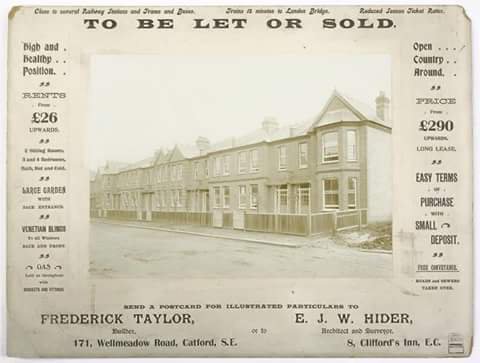
In the early years of the street rent levels were low – around five years after they were built they were being offered for rent as ‘seven roomed houses, in good locality, bay windows, forecourt, rent 7s per week’ – that’s 35p for those without pre-decimal knowledge (2).

Rent levels seem to have slightly reduced in the next decade – 21-32 were sold in 1894 as the owner was bankrupt – a couple of hundred properties across London were sold at the same time. The advertised rent level at Ardmere Road would have averaged 31p a week (3).

A decade later, when there were further sales, rents had gone up significantly – at 21, 22 and 23 they were 9/- (45p), 8/6d and 9/- respectively.  Whereas at 4 and 5 they were more expensive at 10/-. A few hundred metres away on similar sized houses on Ennersdale Road houses were offered at 13/- a week (4). The rent increases  probably related to the opening of the station at Hither Green.  21 – 23 were sold again in 1907 – rents hadn’t changed though (5).

The tenanted value of the houses was around £140 – based on the sale of an unspecified pair of properties in 1908 (6).   The trio of 21-23 Ardmere Road homes was again sold just before the outbreak of World War 1 – rent levels had declined slightly to 8/6d. The freeholds of most of the street were sold at the same time (7).

Perhaps part of the reason for the frequent changing of hands were difficulties in collecting the rent. There was a case of claim and counterclaim at the Police Court in 1897. One of the tenants was alleged to have assaulted the rent collector by hitting him with a chair. The rent collector, who described himself a clergyman of the Church of England, was witnessed to having used language and behaviour that would not been heard coming from the pulpit – calling the tenant a ‘dirty cow’ and then attempting to strangle her after she only offered him 10/- towards rent (and presumably arrears). Both cases thrown out by the Police Court (8).

There was lots of low level crime relating to the street – the O’Connor brothers at 30 appeared several times in court. Hugh was described as a ‘bad lad’ after stealing a ‘whip from a trap’ in Ardmere Road in 1890 (9). He was again in court in 1894 after stealing tinned fruit from a shop on Ennersdale Road (10); younger brother Michael was convicted of stealing from orchard in Nightingale Grove and was remanded for a week the following year (11).

There were a couple of dozen similar reports of theft in the local press between the early 1880s and the outbreak of the Great War. While not attempting to excuse them, most seem to have been born out of the grinding poverty that seems to have existed on the street. A laundress at 23 was remanded for pawning various clothes which belonged to a resident of the nearby, wealthy College Park estate (12).

There were thefts of a marrow in 1886 (13) and milk in 1887 (14), and several occasions of stealing lead piping including from empty houses on the street which belonged to the Finsbury Building Society the same year (15).

There were, of course, alcohol related convictions too, the father and son Lustys, from 21 were together charged with being drunk and disorderly in 1887 (16).


There was an off-licence at 17 run initially by Lewis White, who held the licence from 1879 to 1897. He was also a ‘General Dealer’ and had several brushes with the law, including allowing purchasers to drink outside the off-licence in 1884 (17). He was charged with selling alcohol outside permitted hours in early 1887 (18).

The last event seems have led to the bench refusing to grant him a new licence, so in the end it was transferred to William Barrett (19).  Barrett seems to have tried to extend to 18 in 1898 and obtain a full beer house licence, unsuccessfully on this occasion (20).  Oddly the Ordnance Survey, incorrectly  showed the 17 as a public house when surveyed in the 1890s.  Perhaps that’s how William Barrett’s tenure there appeared to the cartographers, it wasn’t though what the magistrates had approved though! (21)

We will leave Ardmere Road early in the 20th century, the second part of the post returns to the street in 1939 and looks at the changes to the street since then.

Notes

  1. 29 October 1881 – Woolwich Gazette – London, London, England
  2. 26 September 1884 – Kentish Mercury – London, London, England
  3. 27 October 1894 – South London Press – London, London, England
  4. 13 May 1904 – Kentish Mercury – London, London, England
  5. 17 May 1907 – Kentish Mercury – London, London, England
  6. 20 November 1908 – Kentish Mercury – London, London, England
  7. 07 March 1914 – Middlesex Chronicle – London, London, England
  8. 28 August 1897 – South London Press – London, London, England
  9. 26 September 1890 – Kentish Mercury – London, London, England
  10. 20 April 1894 – Kentish Mercury – London, London, England
  11. 30 August 1895 – Kentish Mercury – London, London, England
  12. 6 October 1880 – Woolwich Gazette – London, London, England
  13. 08 October 1886 – Kentish Mercury – London, London, England
  14. 16 December 1887 – Woolwich Gazette – London, London, England
  15. 18 February 1887 – Kentish Mercury – London, London, England
  16. 25 March 1887 – Kentish Mercury – London
  17. 06 September 1884 – Kentish Independent – London, London, England
  18. 14 January 1887 – Woolwich Gazette – London, London, England
  19. 01 October 1897 – Woolwich Gazette – London, London, England
  20. 09 September 1898 – Woolwich Gazette – London, London, England
  21. On a Creative Commons via the National Library of Scotland

Charles Booth’s map is  available from London School of Economics as a Creative Commons.

Notes re FMD

Frederick Taylor – A Corbett Estate Builder

Running Past has ‘visited’ the Corbett Estate a couple of times before – firstly, looking at North Park Farm – whose sale was to allow the development of the estate, and early in the development a walk with one of Charles Booth’s researchers in 1899.  This post relates to a period a few years later in the development and was ‘triggered’ by an advert for the sale of newly built houses on the Corbett Estate that periodically appears on social media.

So where is the row of houses?  Well it certainly isn’t the 171 Wellmeadow Road of the advert (see two photos down) – they are larger semi-detached houses than those pictured above.  The shape of the roof at the right is unusual, and, from a couple of runs up or down almost every street on the estate (with a tiny bit of help from Streetview), it seems to appear on just a small number of roads – there are certainly a few houses at the southern end Ardfillan Road but the bay is wider there with two front-facing windows and the pointed roofs further down the advert are absent; at the northern end of the same road, the houses are again much wider, with two front-facing windows in the bay; a stretch of the terrace towards the northern end of Balloch Road is much closer, the property sizes seem right, but, again, the pointed roofs are missing.  However, the road in between, Birkhall Road, has the perfect match on its eastern side with the right mix on the neighbouring houses along with the rendering on the flank wall.  While there is no house to the right in the advertisement – this was probably just a later phase of the development.

The advert never seems to appear with a date; however, it would certainly be sometime after 1901 as 171 Wellmeadow was not occupied at that point according to the census, however, it probably wasn’t long after, as building work on the street started in 1904 (1) .

There had been considerable  price rises on the estate since we last ‘visited’ the Corbett Estate in 1899 with Charles Booth’s researcher, Ernest Aves, at that point the three bedroom houses were around £252, perhaps 5 or 6 years later, the advert prices them at £290.  Rents of £26 a year were only a £1 more than in 1899 though.  The houses advertised were more expensive than the similar houses being developed in Lee by the builders WJ Scudamore which were being sold for £265 around the same era.  The differences are minuscule compared with current prices – one of the houses in the photograph sold for just under £500,000 in 2015.

So which of the other streets on the estate did Frederick Taylor’s firm build?  The only certainty is the terrace in the photograph, however, it is very noticeable that the streets around Birkhall Road – the two mentioned above plus Ardoch Road, where the unusual gables are also present, have much less homogeneity than other streets on the Corbett Estate so maybe this ‘block’ was the area constructed by Frederick Taylor.

Frederick Taylor was certainly not the only builder to work on the Corbett Estate – as was noted in an earlier post, much of the work was sub-contracted by Corbett, whom Booth described as ‘speculator in chief‘; Running Past has covered one of the other sub-contractors, James Watt, who built a lot of homes elsewhere in Catford in his own right, along with running a chain of cinemas.  Another was John Lawrence, of whom little is known other than his name cropped up in a legal dispute between Cameron Corbett and the Borough Council relating to unpaid building control fees (2).

So who was Frederick Taylor?  He was certainly living at 171 Wellmeadow Road (above) when the census enumerators traipsed through the nearly completed Corbett estate in 1911 – the family had been living in Lambeth where he was listed as a builder a decade earlier.  He was then 49 and from Camberwell; he was married to Charlotte from Chelsea, with three children the youngest of whom was born in Lewisham in 1907.  There was an 11 year gap back to the middle child who had been born in Dulwich. Sadly Frederick was not to live much longer, he passed away in 1914; the family seems to have moved to Eltham Road in Lee just before his death.

The 1914 Kelly’s Directory lists a builder, Frederick Taylor, at 152 Muirkirk Road (below), this may have been the same man, as Kelly’s Directories always seemed a year or two behind reality, or it could of course have been his son, also Frederick, carrying on the business.  There was no mention though in the next available directory in 1917 though.

As for the architect, Ernest Hider, he had been born in Lee in 1871, and stayed in the area until his 20s – he was a Surveyors Clerk in 1891.  By the time the houses in Birkhall Road were being built he had moved away, the 1911 census had him listed in Clacton and seems to have been an active mason.  By the time the 1939 Register was drawn up he was in the Surrey commuter belt, where he died in 1960.

Notes

  1. Godfrey Smith (1997) ‘Hither Green: the Forgotten Hamlet : Including the Corbett Estate’ p42
  2. The Times (London, England), Monday, May 06, 1901; pg. 14; Issue 36447.

Census and 1939 Register data is via Find My Past

Kelly’s Post Office Directory data from University of Leicester 

If I have unintentionally breached your copyright on the ‘featured’ image (like several others) please do let me know and I will happily properly credit the image,

A Victorian Walk Around the Corbett Estate

A month or two ago it was noted in another post on Running Past, that there had ‘probably never been a single sale of land around Hither Green and Lee that has been more significant than the sale of North Park Farm by the Earl of St Germans in 1895 as it allowed for the development of was initially known as the St Germans estate, now generally known as the Corbett estate.’ This post picks up the story a few years after the sale after development was well under way, but far from being completed.

We return on 15 November 1899 in the company of one of Charles Booth’s investigators, Ernest Aves (there is a biography of Aves here)and PC Lloyds from Ladywell Police Station, who lived locally in Harvard Road.  The walk gives a fascinating insight into the early days of the estate.120px-charles_booth_by_george_frederic_watts  Charles Booth (picture Creative Commons), the centenary of whose death is on November 23, 2016, conducted an ‘Inquiry into Life and Labour in London’ between 1886 and 1903 – for much of the city he produced wonderfully detailed maps coloured on the basis of income and the social class of its inhabitants.  His assessment was based on walks carried out either himself or through a team of social investigators, often with clergymen or the police, listening, observing what he saw and talking to people he met on the road.  Sadly, no map seems to be available for most of the walk but below is an extract which includes the most southerly part of Hither Green that seems to have been mapped – available from London School of Economics as a Creative Commons.

image

booth

Albert Lloyds was about 35 and has been in the police for 11 years all of which has been in Lewisham, Booth feels that he is unlikely to get promotion due to his lack of education, he had five children in 1899.  By the 1901 census Albert Lloyds, from Newchurch in Kent, was still living at 35 Harvard Road, with his wife Ellen and 7 children in a two bedroom house.

Corbett was described as ‘speculator in chief’ but was subletting much of the work, the contractors included James Watt, whom Running Past has already covered.  The estate is described as being mainly for the ‘lower middle class’ and two styles predominated – ‘a small single fronted house letting at about £25 and a somewhat larger double-fronted house letting at £36 to £38.‘  The larger houses in Brownhill Road attracted a rent of £60.  These were presumably monthly rentals.  But there were lower, weekly, rents around ‘working class’ Sandhurst Road.

Aves seemed almost surprised that ‘many of the houses throughout the estate are said to be owned by their occupiers‘. Sale prices, on a leasehold basis a year earlier in 1898 had been £379 to £470 for the largest six bedroom homes; £298 – £353 for four bedroom homes and £215 to £252 for the 3/4 bedroom homes.  The smallest 3 bedroom homes on the estate were not offered for sales until 1903 (1).  The biggest of these are now fetching over £1 million, as was noted in a recent post in Clare’s Diary.

Duncrievie Road
His starting point was where we had left the estate a few years earlier in a post about the farm that came before the estate – North Park.  The original farm, occupied for years by William Fry, had gone, but houses occupied by the Sheppards were still there.  Eliot Lodge (below), at the corner of Hither Green Lane, was still occupied by Samuel Sheppard and the other, the former house of Edward Sheppard, was occupied by the Chief Agent for the estate, Robert Pettigrew who was from Edinburgh – it was referred to as North Park House in the 1901 census.  Both were given the second highest rating by Aves/Booth – red – ‘Middle class.  Well to do.’  Oddly Pettigrew wasn’t always in this trade, he’d been a storekeeper in 1881, but may have come across Corbett whilst the latter was developing in Ilford – he returned to Essex after he retired.

image
Springbank Road
While some of the shops had been built, but certainly not all and only two or three let – this was perhaps not surprising, while the road was laid out, the houses were yet to be built.  The bustling parade of a decade later (see below – source eBay September 2016) was yet to come.

springbank

The only houses were the other remnants of North Park farm, the ‘pink’ (Fairly comfortable.  Good ordinary earnings) former farm cottages at the corner of Hither Green Lane.
image

Wellmeadow and Broadfield Roads
The northern parts of the road, closer to the station, had already been built as had the ‘large Weslyan Chapel building’ (covered a while ago in Running Past) but south of Brownhill Road it was still under construction.

HG Church

Source – eBay February 2016

The pattern was the same with Broadfield Road (wrongly mentioned at Brookfield). Aves referred to the streets as a ‘pink barred’, this is a slight variant on some of his earlier definitions – in correspondence, this seems to mean ‘high class labour – fairly comfortable good ordinary earnings’

Brownhill Road
This was oddly described as ‘the swell road of the estate’ – many of the larger houses had already been built and were ‘red’ with a few of the pink barred blocks of houses constructed.

Ardgowan, Torridon, Arngask and Fordel Roads
Ardgowan Road, north of Brownhill Road, had been completed by the time Lloyds showed the estate to Aves, but to the south, construction was still ongoing; the opposite seemed to be the case with Torridon Road. Arngask and Fordel Roads were both completed, but Aves merely seemed to pass by noting the same pink barred colouring of the other two streets.

torridon-1910-l-wiki

Torridon Road from a decade or so later via Lewisham Archives on a Creative Commons

Glenfarg and Sandhurst Roads
These were described as ‘the two working class streets’  they were largely built, unlike much of the rest of the burgeoning estate, to rent on a weekly basis and these were the slightly lower graded pink (without barred element).

Aves with his interest in poverty lingered here longer, seemingly mainly on Sandhurst  Road –

‘most occupied by a decent class, but many on the down-grade.  Two families (per house) frequent, and even in passing many signs of deterioration observable.’

Many living in these streets were employed on the estate and would be expected to leave when the work was finished.  Given the estates position in then suburbia, Corbett presumably felt that to get the workers, he needed to build houses for them first – there seemed to be no philanthropy here, just business necessities.  Certainly, Smith noted that these houses were much later coming onto the market (2).

Maybe influenced by his companion, Aves noted that

The street (Sandhurst) is not getting a good name, and disorder and drunkenness are not uncommon, in spite of the absence of licensed houses in the intermediate neighbourhood.

Booth still felt the road to be mainly pink, but, apart from the shops of Sandhurst Market, that it would be turning ‘purple’ (‘Mixed. Some comfortable others poor.’)

It took another eleven years for the the building work to be completed with homes on Verdant Lane and Duncrievie Road being finished in 1910 (3).  The difference between 1894 and 1914 is enormous as the maps below show (both maps on a Creative Commons from the National Library of Scotland).

image
At some stage in the not too distant future we will pick up the story of the estate just before World War 2, to see whether the predictions of Aves and Booth proved to be correct.

Notes

  1. Godfrey Smith (1997) ‘Hither Green: the Forgotten Hamlet : Including the Corbett Estate’ p40
  2. ibid p40
  3. ibid p42

Census and related data comes from Find My Past.

Well Hall Stream – A Tributary of the Quaggy, Part 1

Unlike some of the other tributaries of the Quaggy, the early stages of Well Hall Stream are obvious; there seem to be at least three sources relatively high up on Shooters Hill.  There are a couple of small streams tumbling down through Jackwood on the southern side of Shooters Hill – just to the east of Sevendroog Castle.  One of these has a clear valley and is big enough to have a bridge crossing it on the path through the woods and has a clear flow in wet weather.

image

There is also a rather soggy area just below the café on the western side of Oxleas Meadow – this would seem to be a spring and there a clear signs of fluvial erosion there both on the ground and the tell-tell upward pointing notches of contours on Ordnance Survey maps.

image

All three of these sources were constrained by concrete when leaving the meadow or woodland to enter culverts under Crookston Road when the houses were built in the 1930s.  Whether the water is piped down its previous course or enters the road drainage system is unclear.

In the very soggy winter of 2013/14 the culvert to the east either became blocked or couldn’t cope with the flows – oddly these seem to be the responsibility of residents to maintain.  Flooding resulted and residents dug a small drainage channel just inside the meadow to divert the flow away from the houses and onto Rochester Way. It was still visible two winters on.

image

Top photo source

While there is no evidence of water on the hillside outside the woods, the former course of streams route away from Jackwood are clear to the fluvial flâneur – there is a small switchback with two little eroded notches in Dairsie Road that the developers didn’t fill.

The streams would probably have crossed what is now Rochester Way before coalescing into a a single flow somewhere around Dumbreck Road. There is a gentle downward fall towards the source of the stream’s name – Well Hall – the former route is obvious from the curvature of the thin brown sepia lines of the Ordnance Survey map but much less so on the ground.

I had hoped to hear the sound of submerged water from beneath manhole covers, but the only audible flows on a quiet Sunday afternoon were those of traffic streaming along the nearby, and also partially submerged A2.

The route became clear again with gentle depressions on both Glenesk and Westmount Roads.  There is a rather attractive Methodist chapel, built in 1906 on the northern ‘bank’ of the stream at the junction of Earlshall and Westmount Roads.  It replaced a ‘tin church’ on the same site and was opened as Walford Green Memorial Church. Walford Green was an important local figure in Methodism rather a predecessor of a fictional E20 square.

image


Even on the oldest Ordnance Survey maps the stream isn’t always visible here, presumably having suffered from minor diversions to allow the cultivation of the farms that emerged after the break-up of the Royal Parks at Eltham Palace – something covered before in the blog in relation to Horn Park Farm.  The farm here was Park Farm.  It was also home to a 1000 yard rifle range on the first OS survey in the 1860s.

image


The stream continues down Earlshall Road which starts to have a look of the Catford – Hither Green border; this is not surprising, it is another ‘Corbett Estate’ of a similar vintage – it is ‘carbon-dated’ via the impressive and imposing looking early Edwardian school – Gordon Primary School, which has retained temporary classrooms from WW1 when the area upstream was home to temporary housing for Woolwich munitions workers and their families.

image

Not long after, and again with a slight depression in the road, the stream ’emerges’ into Well Hall Road and then into the eponymous Pleasaunce.

The journey  of Well Hall Stream to the Quaggy in what is now Sutcliffe Park will be concluded next week.

The Firs – A Country House of Lee

From the early 17th century Lee became ‘home’ to a small number of large houses for the extremely wealthy.  Several still remain – two on Old Road, the Manor House (now library) and Pentland House – used for student and other housing, along with The Cedars on Belmont Hill.  Several were lost to Lewisham’s development – notably, Lee Place – which was covered on the blog last year, and what latterly was referred to as Dacre House.

The Firs was a large early Georgian house, on the corner of Old Road and Manor Lane Terrace, like Lee Place, it is long gone but its presence is still visible in the post-demolition street patterns in the area, particularly the on the western side of Old Road in Roads such as Abernethy and Lochaber.

image

The Firs was a large red-brick house was a  built around 1700 as the ‘town’ residence for the Papillion’s, a prominent Huguenot banking family who had prior to that lived in Norton Folgate in Spitalfields as well as having a country house in Acrise, near Folkestone.  Three generations of Papillion’s lived at The Firs over the next century – the first two owners Phillip, who died in 1736 aged 80, and David who lived until 1762 were MPs for Dover.  The final owner, another David, passed away in 1809, when The Firs was sold.

The house had a series of owners after the Papillion’s sold the house in 1809.  Notable amongst these was, General Edward Paget who had been second in command to the Duke of Wellington for a while in the Peninsula War, before becoming Governor of Ceylon and then Governor of the Royal Military College at Sandhurst.

The Firs was later home to the Sladens, who were described as ‘hospitable at home, also charitable to the poor of Lee’ – their family tomb is in the old churchyard at St Margaret’s Lee and is listed – Joseph lived at The Firs until 1855, when the house was sold.

image

The last owner was John Wingfield Larking (1801- 1891), who probably moved in after the Sladens – he was certainly on the electoral register by 1862.  Wingfield Larking was a member of a wealthy Kent family who had been a merchant in Egypt and British consul in Alexandria between 1838 and 1841.

One of the more interesting features of the latter years of The Firs happened in 1884 when Wingfield Larking appointed a young Thomas Sanders, who had been working as a gardener at the Palace of Versailles, to look after the grounds.  Sanders created a winter garden and a series of large conservatories at The Firs.  The winter gardens became well known and a trio of pictures were painted by Arthur William Head.

image

For Sanders, The Firs was a stepping stone and he moved on to edit Amateur Gardener in 1887.  Sanders settled in Ladywell and became a Councillor for Lewisham Park in 1912 – his story in interesting enough to do a post in its own right at some stage.   His gardens only lasted a few years longer – Wingfield Larking died in 1891.

image

The area changed rapidly after Wingfield Larking died; The Firs was sold and by 1894, OS maps show  the first homes on Lochaber Road and Lee High Road had already been completed on the former estate, and the housing on the western side of Old Road, Abernethy, Murillo and Rembrandt Roads would soon follow.

image

So who were the builders? The Scottish Lochaber and Abernethy Road names could have links with Cameron Corbett, who named all of his roads in both his Eltham and Hither Green/Catford borders estates after Scottish towns and areas. Similarly, it could have been one of his builders James Watt who was of Aberdonian and Orcadian descent.

A more likely answer though is the local building firm, the Siderys – there is a glazed panel above the door of 51 Murillo Road, on the corner of Rembrandt Road noting the base the fourth generation within the building trade.

The earliest was William Sidery, who was born in 1771 and died in 1825; the second generation of builders was also William Sidery, who had been born in Lee in 1803 and by the 1851 census was a master bricklayer employing 8 men; his son, predictably, also William (born in 1836) was apprenticed to his father. By 1861, William was listed as a builder at Grove Place on Lee High Road (just below Eastdown Park). He remained there until his death in 1876 – which seems to be noted on the side of the building (sadly partially hidden by a modern drainpipe).

William (1836) was listed in 1881 in Grove Place with 8 children with Elizabeth, including three sons William (1862) and John Sutton (1863) listed as carpenters and Charles (1864), a painter. In the 1891 census William was listed as a bricklayer living in st Mary’s Villas on Pascoe Road; he was to die the following year before The Firs estate was sold. The adult sons had all moved out by that point. Elizabeth, the widow of William (1836) moved into 72 Murillo Road where she remained until her death in 1908.

It isn’t clear where John was living in 1891, but by 1901 was living at 51 Murillo Road and listed as a house decorator with Mary who he had married in 1886 and two children. John died in with Mary passing away in early 1939. Their son Sydney is listed in the 1939 Register as living next door at 53, although this isn’t that clear on the register itself and could easily be at 51.

While it is possible that the Siderys built the estate, for a firm of this size a development of a couple of hundred homes may have been beyond their range, although much will depend on the extent to which work was subcontracted. They may just have worked on the estate.

Picture Credits

The three pictures by Arthur William Head (a view of the house, the Fernery and the Winter Garden) are owned by LB Lewisham and are accessible via the Local History and Archives Centre, but have been made available through the BBC’s Your Paintings site; images and data associated with the works may be reproduced for non-commercial research and private study purposes.  Non Commercial research includes blogs such as this.

The black and white picture is photographed from the information board on Brandram Road, opposite St Margaret’s church.

Census and related data comes via Find My Past

Hither Green Ditch – A Tributary of the Quaggy

Hither Green Ditch or Hither Green Quaggy is a short tributary which flows, hidden, through parts of Downham, the borders of the Corbett Estate and Hither Green.  The nomenclature ‘Ditch’ is used quite a lot within the Quaggy catchment, it shouldn’t be seen as belittling of derogatory it is just the way smaller streams are described – there are Milk Street, Grove Park,  Border and Petts Wood further upstream.

Like the Quaggy itself, there are probably several sources to the stream.  There is certainly some evidence on a 1920s OS map of a thin blue line going back towards Grove Park across the railway.  Any evidence of contour lines that would have supported this as a source were obliterated with both the construction of the main line and the railway sidings. 20140718-184743-67663559.jpg

There is some support for an east of the railway source on the Environment Agency flood risk maps too.

HGD EA

To the west of the railway, there were ponds on Shroffold Farm  (now the location of a mosque at the junction of Verdant and Whitefoot Lanes and Northover, which Ken White  (1) had the source as – he is almost certainly right.  While the pond may have been fed by a small spring – there may also have been some run-off from the area around Whitefoot Lane, which is gently sloping down towards the former pond at this point. (See map below on a Creative Commons from the National Library of Scotland).

HGD 1

Another branch is clear too from the  tell-tell notches in contour lines of fluvial erosion on Ordnance Survey maps point further uphill, towards the top of the hill on the Downham Estate.  While the stream wasn’t marked on old Ordnance Survey maps – it may have been dry by then – its course is obvious on the ground with distinct dips on Tristram and Camlan Roads, similarly there is a depression where it would have crossed Northover at its junction with Durham Hill and Shroffold.  The north easterly course becomes slightly less distinct as land flattens out crossing Roundtable, Pendragon and Ballamore Roads.  There is a clearer depression in the north eastern end Reigate Road, where there is an attractive grassed square surrounded by houses.  These houses have problems with damp and there is local knowledge of an underground stream there (see comment from Brian below).

image

There is also a distinct dip Railway Children Walk (named after the Edith Nesbit book – Nesbit lived for a while in Tree Gables on the opposite side of the railway).  The ‘Ditch’ would them have continued into what is now the cemetery – although its current route would be blocked by a relatively recent mound of earth; the flood risk map (towards the top of the post) shows its likely route quite clearly too.  A 1961 OS Map shows both the branches still partially visible at that stage (on a Creative Commons from the National Library of Scotland).

HGD 2

Once in the cemetery there is a perceptible dip suggesting a course.  The cemetery has two distinct elements – initially the course is through the bleaker twentieth century part with more regimented lines of graves, fewer mature trees and with a partial backdrop of the railway sidings and yards.

20140718-185054-67854639.jpg

It has a slightly desolate feel to it when compared with the delightful, slightly overgrown Victorian northern quarter with a decaying dissenting chapel (built by William Webster, covered by Running Past in 2016) – partially destroyed by a World War 2 bomb.

20140718-184931-67771258.jpg

Before leaving the cemetery, a detour of a hundred metres or so to the south of the chapel is worth making to the memorial to the Sandhurst School disaster, where 38 children and six teachers died in a day time bombing in 1943, perhaps more on that another day.20140718-185239-67959997.jpg
At the north of the cemetery there is what looks like a ditch, while the was no evidence of any water it seems likely that this was its course as a local resident remembers a stream at this point (see comment from Dean). He also recalls it being piped to follow a course behind South Park Crescent and then towards Oak Cottages. This is certainly the route that contour lines would suggest.

The stream would have joined the now not particularly Verdant Lane just beyond Pasture Road – there is a clear dip in the road, adjacent to the Verdant Lane Community Wildlife Garden. There is no waterway to see, although there is a speedboat that has been ‘moored’ in a front garden for as long as I can remember.

20140718-184347-67427171.jpg

At around this point, close to the junction with Sandhurst Road, Hither Green Ditch would have been joined by another small stream, which can be traced through the Corbett Estate.  Going up stream, probably crossing Minard Road mid-way between Dowanhill and Hazelbank Roads and crossing Dowanhill Road around its junction with Broadfield Road – in quiet moments there is the sound of water beneath manhole covers at this point.  The contours are visible on the 1961 1:25,000 Ordnance Survey map below, (on a Creative Commons via the National Library of Scotland) with just perceptible dips in the roads. While I didn’t hear any sounds of subterranean water emerging from manhole covers – those who live there have heard them around these streets.

HGD 3

There is also evidence there of a water-filled ditch at the back of homes on Hazelbank Road and the Excalibur Estate, there is a thin-blue line on the 1961 map and seemed big enough for a swan to be able to use it (see comment from Diane on one of the posts on the Quaggy).  It seems to have had an issue behind 244 Bellingham Road and disappeared into a sink between 143 Hazelbank Road and 6 Wentland Close – see map below on Creative Commons via National Library of Scotland).  There are clear sounds of water rushing below the street from a couple of manhole covers at the northern end of Longhill Road, but the sounds peter out further south; it may be that the source is on the eastern side of Forster Memorial Park, but there isn’t any cartographical or on the ground evidence of it.

HGD 4

There seems to be a second source for the tributary – water below a pair of manhole covers can be clearly heard at the T junction of  Castillon Road and further north on Broadfield Road, close to the junction with Hazelbank Road.  Similar pairs of manhole covers and dips in roads can be seen on Gilton Road and on Waters Road, but, sadly given the street name no sound of water, nor was there any clear evidence  further south.

This tributary stream probably provided the water for South Park Farm, a small farm of around 70 acres centred around Dowanhill and Hazelbank Roads. After moving to somewhere around the Torridon and Brownhill Roads junction, the farm was renamed ‘Longmisery’ (2). It merged with North Park Farm (which we will ‘visit’ further downstream) in the mid-19th century.  Perhaps this small stream should be called South Park Ditch.

The main stream’s original course would have taken it across what is now the South Circular just to the west of the railway bridge before being bridged by the railway behind the junction of Springbank Road and Hither Green Lane. To the east of the railway it flowed through what are now the gardens of Milborough Crescent, just south of its junction with Newstead Road. The Crescent followed the long curve of the stream before it reached and was bridged by the railway on Manor Lane.  While it is not visible at this point, it is certainly still flowing – there was a serious diesel spillage in early 2016 in the yard which polluted Quaggy and lower reaches of the Ravensbourne.

The stream flowed alongside Manor Lane for another couple of hundred metres before turning west-north-west and meandering across the line of Longhurst Road, joining the Qauggy where it dog-legs to the north.  This is all now covered.

Around here the stream would have been joined by a small tributary that seems to have ‘risen’ just the other side of the railway on what was North Park Farm which was roughly in between where Duncrievie and Elthruda Roads are now. The sale of the 278 acre farm to Archibald Cameron Corbett in 1896 was to allow the development of the western side of the railway. Despite being a junction for around 30 years, Hither Green had only opened as a station in 1895. A new booking hall was built to the west of the station in Springbank Road as part of the development – its red brick gateposts are still visible as the entrance to a new housing association development. The original stationmaster’s house survives, adjacent to the gates, at 69 Springbank Road.

20140718-185407-68047305.jpg
The tributary flows through the nature reserve of Hither Green Triangle between platforms 4 and 5 of the station; this offers the only above ground remnants of the tributary or indeed the main stream. From the far end of platform 5, the stream is just visible, way below the platform level – not surprisingly given the viaduct the railway is on. The water was glistening in the sunlight when I visited. While access to the nature reserve is rightly limited, its management plan, while confirming the stream’s presence gets its direction of flow wrong (although the original mistake seems to lie with the now defunct London Ecology Unit).

‘A small stream trickles from north to south across the east of the site’

20140718-185534-68134763.jpg
The tributary would have originally emerged from the embankment from platform 6 somewhere between the house and the bus stop before trickling on towards Longhurst Road.

20140718-185800-68280126.jpg
The final outflow of the substantive stream into the Quaggy would have been around where it is bridged by Fernbrook Road, although nothing is obviously emerging from the brickwork ‘bank’, presumably long since culverted away.

Notes

  1. Ken White (1999) “The Quaggy & Its Catchment Area”
  2. Godfrey Smith (1997) ‘Hither Green: The Forgotten Hamlet’ p12