Tag Archives: V-1

War and a Lee Street – Taunton Road

Over the years Running Past has looked at the impact of the Blitz and the V-1 and V-2 attacks at the end of World War Two, as well as looking at the preparations that were made ahead of war being declared.  This post takes a slightly different tack, looking at one street and the impact that was felt there – Taunton Road, a street of mainly Victorian terraced houses running from Burnt Ash Road to Manor Lane.

In the main we’ll look at World War Two, but we’ll start with World War One; like virtually every other street there were young men who went to war from Lee but who never returned….

Frank Eugene Gamblin was just 19 when he died on 31 May 1918 in Northern France.  He was the son of Thomas and Edith Gamblin of 50 Taunton Road (at the corner of Hedgley Street).  He was a Private in the Devonshire Regiment.  Frank had been working part time as a ‘Milk Boy’ aged 12 in 1911, still at school and living in Rhyme Road in Lewisham.

Just beyond the school, at 58 Taunton Road, lived William Jupp; he had been born in Lee, although the family have moved to Hove for a while but was in the street by the 1911 census. At that point he was still at school, but just over seven years later, on 24 August 1918, he died near Albert in Northern France, aged just 21, a rifleman in the London Regiment.  His parents, Rachael and William, were still living in Taunton Road.

James Woodnott was a Private in the London Regiment who died at Aubers Ridge on 4 October 1918 in Northern France and was buried close by.  Born in 1886 he was the oldest of the five who died. He had grown up in Dacre Street; by 1909 he had married Fanny, and in 1911 he was working as a carman living in Neuchatel Road in Catford.  They were living at 83 Taunton Road, opposite the park entrance, as war broke out with two children, born in 1913 and 1914.

Another man with links to the street was Alfred Edward (Edwin) Braine. He had a couple of rooms at number 13 before he went to war. Born around 1881, he seems to have lived on the street for much of his life – growing up at 37. He was serving as a Sergeant in the Royal Field Artillery when he died towards the end of on the war on 20 September 1918 and is buried or commemorated at the Vis-en-Artois Memorial. He may well have joined the Army at 18, someone of a similar name (the middle name is listed as Edwin) and age signed up in October 1899 in the same regiment.

Charles Frederick Broad had grown up in Taunton Road, born around 1896 his parents, Rose and Huntley, were living at 84 Taunton Road by 1901.  He was still at school in 1911 but died less than six years later aged just 20 in Belgium on New Year’s Day 1917 where he was buried at Spoilbank Cemetery (pictured below).  He was a Lance Corporal in the London Regiment.  His parents were Huntley Charles Broad and Rose Matilda Broad still of 84 Taunton Road.

Entrance stone for Spoilbank cemetery

Two doors away at 80, was the mother of Ernest E Jackson; he was a Corporal in the Royal Fusiliers and died at Gallipoli on 13 August 1915, aged 22.  He may have no direct contact to Lee other than through her – Mrs Florence Brosinovich, who had married Henry in 1893.  Ernest was almost certainly born Brosinovich.

For reasons that will become clear, we will continue with the group of houses to the west of the park entrance where the Brosinovich and Broad households lived.  Unlike the bigger houses in the streets to the south, that part of Taunton Road hadn’t changed that much between 1911 and the outbreak of World War Two, it was still predominantly single-family homes, mainly housing skilled working-class households, when the 1939 Register was collected.

Florence Brosinovich and some of her family were still at 80, they shared with another couple. 80 was the only shared house in the group, two households with 5 people and all but Florence worked. 

The Broads were still at 84, Charles’ younger brother was working as a local government officer and his father in his 60s was working as a printer.  Their neighbours at 86 were the Buttons where Robert worked as a lorry driver and got the ‘heavy work’ supplement which would have entitled him to larger rations.  On the other side at 82 were three women sharing, including typist Doreen Tew, who would have turned 19 in the autumn of 1939.

Others in the group of houses to the west of the park included Amos and Elizbeth Howick at 70 who were in their 60s, he was a bricklayer and he too would have been entitled to the ‘Heavy Work’ supplement in the rations.  The Wilsons at 74, included paper hanger Henry in his early 50s, his work wouldn’t have got the supplement.

A little further down the street was Hedgley Street School (now Trinity), which is pictured above; there is a separate post on this but just before the 1939 Register was collated most of the children would have been evacuated to Ashford in Kent.  Although given it was another year until the start of the Blitz, many children will have drifted back to Taunton Road and neighbouring streets by the time bombing started.

As the children moved out, the Air Raid Precautions (ARP) service moved in.  Their role has been explored in an earlier post but one of the but several of the Noble family from 49 Lampmead Road were to be based there.  This included Phyllis (later Willmott) and her brother Joe who was injured when school bombed and seriously damaged with the front part largely destroyed in 1941 – the school never re-assembled.

Oddly the Nobles were to move to the house next door to the school (52) which had a yard (now part of the school playground) for Phyllis father’s building business – a trade that would have been kept very busy with repairing local bomb damage.

One of the earliest bombs to hit the street was on 25 September 1940 when an Anderson shelter in the garden of number 1, a small house on the opposite side to Sainsburys, took a direct hit – Charles (who worked at RAF Kidbrooke) and Claire Rivers both died, along with their 7-year-old daughter Sylvia – orphaning several other children.  There were 11 there in October 1939, including five who were redacted presumably children who weren’t evacuated. One of the surviving children, Ruby, ended up in an orphanage but was discovered by a brother were returned to Lewisham on leave and reunited her with other family members.

The deaths at number one weren’t the first from the street during World War Two though.  Sylvia Wickens from number 7 had volunteered to be an ARP Warden, she was based in Lewisham Town Centre and was one of 41 who died at Albion Way on 11 September 1940, when a public shelter took a direct hit. 

Almost four years later another resident of the street died in an attack on Lewisham town centre – Maude Clarke from 85 died in the High Street V-1 attack in July 1944.

Returning to the Taunton Road, the most damaging raid was just before Christmas in 1940, when the section of the street that we covered above in relation to the 1939 Register was hit by a High Explosive bomb on 15 December.  82 probably took a direct hit as there was most damage there, but several other houses were destroyed beyond repair and replaced after the war with council homes.

At 82 there were two deaths – one was the 23-year-old Monica Tew, who was listed as the daughter of H Tew. It may be remembered that Monica’s sister, Doreen was living there in 1939, the Tews may be have been displaced by earlier raids elsewhere.

82 was a shared house by 1940, also there were the Setons whose 7-year-old daughter Elizabeth also perished.  She had probably been originally been evacuated (see above) but had later returned to Lewisham.

Assuming that Florence Brosinovich had remained at 80 in the year since the 1939 Register was collected, she would have been made homeless – it seems that she moved to somewhere in the Reigate, Godstone, Dorking and Epsom area of Surrey where she died before the war was out in 1943.

There were other bombings on the street – lots of incendiary bombs fell around the junction with Wantage Road on 8 December 1940, not obviously causing any significant damage.  At some stage houses closer to the now Sainsburys site were destroyed, although this was either missed when I went through the ARP logs or wasn’t recorded, not every incident was on busy nights. 

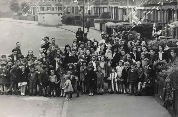
At the end of the War, on VE Day there were celebrations of the end of the war, no doubt they were tempered by the deaths and injuries to friends and neighbours.  There was certainly a party on Taunton Road, possibly two.  The photograph above is taken from around the park entrance looking back towards Wantage Road – there is a concrete air raid shelter in the background.  The one below is in the section close to Burnt Ash Road that was redeveloped 20 years or so later. 

Notes & Credits

  • The photograph of Spoilbank Cemetery is via Wikipedia on a Creative Commons
  • Thank you to David Carter for the information about his family who were orphaned in September 1940 link here
  • The photographs of VE parties are from the collection of Lewisham Archives, they are used with permission but remain their copyright
  • The photograph of Hedgely Street School is from a booklet produced by Church of the Good Shepherd, Lee in 1956, p15 – it remains their copyright and was accessed via Lewisham Archives and was used with the permission of both
  • The census and related data comes via Find My Past (subscription required)
  • The World War One casualties come from the Commonwealth War Graves Commission website
  • Most of the detail of the bombing raids come via the ARP Log for Lewisham which is held by Lewisham Archives
  • Thank you to Denise Whibley Baba on Facebook for details of Alfred Edward (Edwin) Braine.

World War Two Damage on Springbank Road

There have been several posts in Running Past on World War 2 bombings and post-war reconstruction, many of these have been around V-1 and V-2 attacks such as those on Lenham Road, Lewisham Hill, along with a pair of Hither Green ones – Nightingale Grove and  Fernbrook Road.  More recently Running Past has covered the attacks that happened on three nights on their 80th anniversaries – the First Night of the Blitz of the as well as the post Christmas raids on the nights of 27/28 and 29/30 December 1940.  We turn our attention now to the more widespread damage on Springbank Road caused through a variety of attacks. 

Key: black=total destruction, purple=damaged beyond repair, dark red=seriously damaged (doubt if repairable), light red=seriously damaged (repairable at cost), orange=general blast damage (non-structural), yellow=blast damage (minor), green=clearance area

The level and scale of damage becomes clear when looking at the London County Council Bomb Damage Maps pictured above (1) which shows that most of the houses in the street had some form of damage.  Rather than Springbank Road itself, Hither Green marshaling yards, behind the eastern side of the street, were one of the two main Luftwaffe targets in Hither Green during the Blitz, the other being the hospital (2). The damage was much greater to Springbank Road though than to the west of the railway. 

Large swathes of the street were mapped as red by the London County Council surveyors – ‘seriously damaged (doubt if repairable)’ or worse.  In reality, a lot more end up surviving the war than the map suggests.

The Air Raid Precautions (ARP) Service logs make for fascinating reading in terms of trying to work out what damage happened when in Hither Green and the extent of the damage.  However, as we’ve seen in relation the First Night of the Blitz as well as the post-Christmas raids, recording in the log was patchy at best with some high explosive and incendiary bombs only being recorded by the Fire Brigade and others, which were dealt with by local ARP Fire Wardens, were never recorded.

On the third night of the Blitz, on 9 September 1940, it is clear that 136 Springbank Road was hit.  What is less clear is whether this was a direct hit or the fallout from the bombing of the house behind at 51 Wellmeadow Road. This was the house was on the corner with Torridon Road and marked in black on the map above and was completely destroyed. This part of Wellmeadow Road was rebuilt after the War.  William Brown (83) and Alice Budd (56) died at 51 Wellmeadow Road that night. 

136 Springbank was less badly damaged, although it seems to have undergone some wartime or post-war rebuilding work as from the front from the variety of slightly different bricks were used.  One of the inhabitants was Mary Hutcheson – it was a large house that she shared with a couple – the Gallotts.   Mary was seriously injured in the bombing, although she lived for another 6 months before dying at St Alfege’s Hospital (later Greenwich) on 10 March 1941, aged 82. 

Elsewhere on Springbank Road, there was some serious damage further down the street with 213 to 225 completely destroyed. The date of this bombing isn’t clear as the attacks appear not to have been recorded in the ARP log (3).  Unlike 136 Springbank, no one was killed in the attack, although given the scale of the damage it would be surprising if there were no injuries.  213 to 225 (pictured above) were rebuilt as a mixture of Borough of Lewisham houses and flats after the war.  On the other side of the street, there was destruction and rebuilding too, but you have to look closely to see the differences compared with the original Corbett estate homes – the brickwork around the doors and windows is different and the homes are similar to replacement houses in Wellmeadow Rod, which we’ll cover below.

Elsewhere on the eastern side, homes got away with some more limited damage; there had to be re-building work at 211; while its next-door neighbour didn’t survive, the roof, chimneys and bay wall had to be re-built at 211.

There had were several nights during December 1940, notably that of 29/30, when the area on the other side of the railway had seen 1 kg incendiary bombs raining down.  Springbank Road escaped on those nights. However, three weeks earlier on the night of 8/9 December, there had been a similar attack over a slightly wider area – there were a trio of hits at just before 11:00 pm at the southerly end of Springbank Road – none of the repots had any indication of the extent of any damage or casualties.  It could have been the attack that destroyed 213 to 225, as the fire services will have been overstretched that night, although incendiary damage tended to be of a much smaller scale and often put out by wardens.

V-1 doodlebug attacks started to pepper the area from 16 June 1944 – in Hither Green and neighbouring areas, during the first week there had been attacks between George Lane and Davenport Road on 16 June; Lewisham Park the same day; Lewisham Hill and Leahurst Road on 17 June and the junction of Lenham and Lampmead Roads on 22 June. 

Research on the accuracy of V-1s has noted that they had ‘relatively low accuracy… compared to modern missile systems’ but that the aim of the attacks was ‘to achieve its terror and urban damage objectives’ rather than hit specific targets.  So, V1 flying bomb hits on Hither Green and surrounding areas weren’t specifically targeted here.  Indeed, as we have mentioned in other posts on V-1 attacks there is some evidence to suggest that false intelligence was spread back to Germany which indicated that the early V-1 flying bombs were overshooting the north west of London and latter ones were re-calibrated slightly leading to south London boroughs such as Lewisham, Woolwich and Croydon being disproportionately affected.

At around 7:15 in the morning of Friday 23 June 1944 Hither Green had a double hit either site of the railway – Fernbrook Road, which Running Past covered a while ago and Springbank Road; where the block of Corbett Estate housing of 104 to 116 Springbank Road was either destroyed or had to be demolished along with the similar houses behind in 27-37 Wellmeadow Road – the scale of debris blocked Springbank Road for a while.

It was perhaps surprising that only one person died, Annie Taylor (57) who was visiting 110 Springbank from her home at 121 Brightfield Road – Annie was a widow and had lived with her son and daughter in law.  There were several reports of the level of injuries in the ARP log – which were thought at one point to be as high as 25, although final tally seemed to be 14. 

We don’t know the identity of those injured but from the 1939 Register we can work out something about the people who were living in 104 to 116 Springbank Road and the houses behind in 27-37 Wellmeadow Road.  Before doing that, it is worth remembering that the houses had been built as suburbia for the middle classes of Victorian and Edwardian London.  The houses in Springbank Road were some of the later ones built on the Corbett Estate and didn’t appear in the 1901 census, but were in the 1911 edition. The difference between Springbank Road and nearby streets such as Ardmere Road in 1911 is dramatic.  The latter had been built as working class housing with the small houses generally shared between two households with income coming from manual work.  In Wellmeadow and Springbank they were office and sales jobs – with several commercial salesmen and clerks along with a cashier and an accountant.  There were no manual jobs apart from servants in 3 of the 11 houses.  Despite the large houses, large households were rare – it was a very different life to that in Ardmere Road.

By the time the 1939 Register was taken, both streets had changed a lot – the middle class had moved out and both Wellmeadow and Springbank Roads were homes to manual workers, the only exceptions being the adult Spurrell sisters at 112 Springbank – which included Edith who was a Ledger Clerk at a bookshop but also worked as an ARP First Aider.  They were more well-to-do than their counterparts in Ardmere Road and Woodlands Street, the households were smaller and there was less sharing.  Only 108 Springbank and 31 Wellmeadow were split between more than one household.  None of the men (or women) were able to claim the ‘Heavy Work’ supplement which entitled larger rations

The housing built after the war on both Springbank and Wellmeadow sides of the site seems to have been private sector; this is unlike many of the other V-1 attacks that Running Past has covered – Hither Green Station, Lenham/Lampmead Road, Lewisham Hill and Fernbrook Road where it was homes built for the local authority.  On Springbank Road 104 to 116 (pictured above) were re-built, initially as houses although most have been converted into flats. Based on Land Registry data, most remain in the private sector although one has been subsequently acquired a housing association. It was very different in Wellmeadow where the houses seem to have been built almost as 1950s versions of their predecessors – again all but one are privately owned, with one has been bought and converted into flats by a housing association.

Notes

  1. Laurence Ward (2015) The London County Council Bomb Damage Maps 1939-1945 – permission has been given by the copyright owners of the map, the London Metropolitan Archives to use the image here
  2. Godfrey Smith (1997) Hither Green, The Forgotten Hamlet p63
  3. It is possible that some mentions were missed when scanning through the very fragile records

Data Sources

  • The ARP records are via Lewisham Archives
  • 1939 Register data is via Find My Past – subscription required
  • Land Registry data is via Nimbus Maps – registration required.
  • The photograph of 136 Springbank Road is via Streeview

The Hither Green Station V-1 Attack

Running Past has covered several of the almost two hundred V-1 and V-2 rocket attacks on Lewisham, including the ones on Lewisham High Street, Lewisham Hill, Lenham Road, Mercator Road and Hither Green’s Fernbrook Road.  They are important to remember both in terms of the death and injuries caused to ordinary Londoners whose stories often get forgotten, but also in terms of their impact on the urban landscape – both in the short-term and longer term.

Another was on the opposite site of the railway to Fernbrook Road around the junction of Springbank Road and Nightingale Grove, very close to the station at 6:18 on the evening of 29 July 1944. The photograph that is part of the Imperial War Museum collection (produced here on a Creative Commons) shows the devastation all too clearly.

The V-1 would have exploded on impact and a blast wave rippled out from the impact point, effectively creating a vacuum in the centre – the combined impact was to both push and pull buildings leading to large numbers of collapses.  The impact was often spread over quite a wide area with total destruction in the centre with much less damage on the outside.  There were memories from someone living at the edge of this attack of gardens ‘full of bits of shattered china and pottery from the houses affected by the bomb blast’ many years later.  The map below  produced by the London County Council during the war (1) shows this well – the darker the hand-colouring, the greater the damage.

Key: black=total destruction, purple=damaged beyond repair, dark red=seriously damaged (doubt if repairable), light red=seriously damaged (repairable at cost), orange=general blast damage (non-structural), yellow=blast damage (minor), green=clearance area

The worst destruction was in Maythorne Cottages and northern end of Springbank Road along with the adjacent ends of Ardmere and Beacon Roads, where, as the photograph shows, there was almost complete destruction.   Although a degree of caution needs to be used with the maps as a few properties that show as destroyed were able to be repaired – notably the former off licence on the corner of Ardmere Road – covered in an earlier post on the street.

There was damage too along  Nightingale Grove from opposite Maythorne to Brightside Road at the southern end. At this end were purpose-built maisonettes and, which seemed to have been built as ‘railway workers cottages’.  There was considerable damage, with the upstairs maisonettes having to be largely rebuilt.

Many of the houses destroyed were homes to some of the poorer residents of Hither Green, as was covered in the post on Ardmere Road.  Given the scale of destruction it is unsurprising that there were deaths in the attack, the casualties seem to have all been at Hither Green Station:

  • Emily (25) and Jean (1) Chapman – a mother and daughter from Walworth;
  • Violet Kyle (25) of 11 Morley Road, who died in the Miller Hospital in Greenwich;
  • Gerald Hill (17) of 278 Brownhill Road, who was in the Home Guard; and
  • William Pontin (38) of Weybridge.

Emily (nee Keleher) was living in Huntsman Street in Walworth when war broke out, and at the time was listed as a Solder Machine Hand.  The Bermondsey born Emily married James Chapman in 1940, although they were probably living together in 1939 with James’ parents.  Jean was just 22 months old when she died.

Violet was from Lewisham although when the 1939 Register was drawn up was living in a shared house in Circus Street in Greenwich.

Gerald had been born in Lewisham in 1927; at the time the 1939 Register was drawn up he would have been around 12 and was not listed locally as he had presumably been evacuated in September 1939.  Assuming that he was still living at home, his parents will have moved during the war as 278 Brownhill Road was vacant when the Register was compiled.  William Pontin appears to have been working as a brewer’s clerk at the outbreak of war in 1939 and was a lodger in a cottage in Weybridge.  The reason for his visit to Lewisham was probably to visit family – a William Pontin of the right age was born in Lewisham and in 1911 was living in Hedgley Street – where his younger brother Ernest still lived in 1939.

A further 17 people were reported as injured as a result of the attack (2).

There were initial reports of the tracks being blocked by debris at the station, although by the following day local lines were running and by 31 July the track was back to full operations.

The post-war rebuilding was a little more piecemeal than in some of the other sites with V-1 damage locally.  One of the early responses was to clear the site and erect prefab bungalows; what is perhaps surprising is that only 9 were built given the area covered and level of destruction.  Those at the southern end of Springbank Road were replaced in the late 1950s or early 1960s by permanent bungalows built by the Borough of Lewisham.

Beaver Housing Society, which seems to have been formed in the 1920s, appear to have owned the houses at the eastern end of Ardmere Road – they rebuilt some of them in the mid-1950s and added a terrace of red-brick houses on the corner of Nightingale Grove.

Both are resplendent with the blue glazed ‘Beaver’ panel, sadly, this is all that remains of Beaver – they were taken over by L&Q in the early 2000s.

The block surrounded by Maythorne, Springbank and the railway was used for offices and related yards. The one on the corner of Maythorne – still survives, home to the building contractors P J Harte.  The opposite corner went through a greater variety of uses – it was last a nursery which closed in the mid-2000s.  It was boarded up by 2012 (see below from StreetView) and new houses completed by the summer of 2017.

The remaining houses were repaired – the differences in the brickwork are obvious in several locations on Nightingale Grove.

Notes

  1. Laurence Ward (2015) The London County Council Bomb Damage Maps 1939-1945 – permission has been given by the copyright owners of the map, the London Metropolitan Archives to use the image here
  2. Godfrey Smith (1997) ‘Hither Green: the Forgotten Hamlet : Including the Corbett Estate’ p64

The Ordnance Survey map is on a Creative commons via the National Library of Scotland.

The marriage and 1939 Register data comes via Find My Past, the details of the deaths are via the Commonwealth War Graves Commission.


https://maps.nls.uk/view/102908716

The Lenham Road V-1 Attack

Lampmead and Lenham Roads are quiet residential streets coming off Lee High Road, they are mainly Victorian terraces.  There are also several infill homes built by the London Borough of Lewisham,or its forerunner.  There is a story behind their presence in the early 21st century streetscape – they are the indirect result of a V-1 rocket attacks which hit the junction of Lampmead and Lenham Roads on just before 5 am on the morning of 22 June 1944.

Running Past has covered several of the almost two hundred V-1 and V-2 rocket attacks on Lewisham, including the ones on Lewisham High Street, Lewisham Hill and Hither Green’s Fernbrook Road.  They are important to remember both in terms of the death and injuries caused to ordinary Londoners whose stories often get forgotten, but also in terms of their impact on the urban landscape – both in the short-term and longer term.

Six died as a result of the attack on Lenham and Lampmead Roads and no doubt many more were injured.  Those who lost their lives were James Joseph Carroll (20) and Patrick Leonard (26) who died at 34 Lenham Road; Hugh William George Harvey (59) who died at 6 Lampmead, Joseph Daniel Barry (55) died next door at number 8, his neighbour Alfred William Roedear (64) died at no 10 – his wife Annie appears to have survived, and Flora Borthwick (37) perished at 12 Lampmead.

What is perhaps surprising is that of those who died only one, Hugh Harvey, who was a groundsman and coach at the outbreak of the war living at 6 Lampmead Road, had lived there when the war broke out (1).  It is worth remembering that the private rented sector was still dominant at that time – accounting for almost 60% of homes – security of tenure, while perhaps slightly greater than it is now, was still limited.  In Lewisham these landlords included some of the bigger builders in the area – WJ Scudamore and James Watt.

During World War 1 there had been profiteering by some residential landlords which had led to rent strikes and unrest which threatened to undermine the war effort.  These had been repeated in the East End of London in 1938 and 1939. In this context, full rent control was introduced early in World War 2.  However, this seems not to have led to a stable community in this part of Lee – similar issues were found with the Lewisham Hill V-1.

The V-1 would have exploded on impact and a blast wave rippled out from the impact point, effectively creating a vacuum in the centre – the combined impact was to both push and pull buildings leading to large numbers of collapses.  The impact was often spread over quite a wide area with total destruction in the centre with much less damage on the outside.  The map below  produced by the London County Council during the war (2) shows this well – the darker the hand-colouring, the greater the damage.

Key: black=total destruction, purple=damaged beyond repair, dark red=seriously damaged (doubt if repairable), light red=seriously damaged (repairable at cost), orange=general blast damage (non-structural), yellow=blast damage (minor)

By the time the Ordnance Survey cartographers surveyed the area in 1949 (see below & note 3), the debris had been cleared and the site filled with 14 prefabs – a small part of attempting to deal with post-war housing needs.

The old Borough of Lewisham put up 1,610 prefabs by 1948 and a further 1,088 by 1955.  They would have no doubt not been that dissimilar to those on the Excalibur estate in Catford (below from 2014).  The prefabs probably lasted until the 1960s when they were replaced with council housing.

As the lower of the two maps above shows, there were several smaller gaps in the neighbouring Aislibie Road (named after Benjamin Aislabie – the last tenant of Lee Place), the result of bombing during the Blitz, the gaps were not used for the prefabs but they too were later filled by post war council housing.

Notes

  1. The 1939 Register didn’t cover armed forces so possible that some of victims had been living there before war broke out, employment details from Commonwealth War Graves Commission
  2. Laurence Ward (2015) The London County Council Bomb Damage Maps 1939-1945 – permission has been given by the copyright owners of the map, the London Metropolitan Archives to use the image here
  3. On a Creative Commons via the National Library of Scotland