Tag Archives: Upper Kid Brook

Beating the Bounds of Lee, Part 8 – Blackheath to Lee Green

We’d started our circuit of Lee at Lee Green during the first 2020 Coronavirus lockdown and the last leg from Blackheath to Lee Green was under the not dissimilar conditions of lockdown 2.0 in the late autumn of 2020. In the intervening months, Running Past followed the long thin boundary of Victorian Lee just before it was subsumed into Lewisham in 1900. The navigation was aided by an 1893 surveyed Ordnance Survey map.

This circuit has been in seven stages up to this point, from Lee Green to Winn Road, passing a street whose residents probably now wish it had a different name – Corona Road; the next stage was through Grove Park; then on through Marvels and Elmstead Woods; the circuit skirted Chinbrook Meadows and followed the appropriately named stream Border Ditch; then another Ditch, Hither Green Ditch, more or less parallel to Verdant Lane and Manor Lane before following the Quaggy from Longhurst Road into Lewisham, then in the penultimate part following a Quaggy tributary, Upper Kid Brook to Blackheath.

We’d left the boundary at a T junction of borders, Lee – Lewisham – Charlton with a replacement of a 1903 boundary marker of a similar style to those seen in several places around the border.

Source – eBay (Sept 2016)

The stone is next to the railway bridge and it is worth a quick turnaround by the first turning on the left, or would have been in 1893. A large Methodist chapel had been built in the mid-1860s and dominated the Blackheath Village skyline and was to do so for another 52 years until a V-2 rocket attack hit it in March 1945.

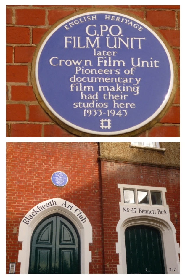
The turning is Bennett Park, which has one of biggest concentrations of blue plaques in south east London – the Physicist, Sir Arthur Eddington lived at number 4 – he was listed as a boarder there in the 1911 census, whilst working at the Royal Observatory. The cartoonist Donald McGill, lived at 5 Bennett Park – he was there when the 1939 Register was compiled. But, perhaps, the most significant is one at the far end for the GPO Film Unit, whose output included the wonderful film adaptation of W H Auden’s Night Mail, which featured a score by Benjamin Britten. The Film Unit also produced some World War Two propaganda films. The building had been partially funded by one the main benefactors of late Victorian Blackheath, William Webster, son of the eponymous main contractor of Joseph Bazlegette, as Blackheath Art Club.
Onwards and southwards, the boundary goes upwards and out of the valley of Upper Kid Brook towards the watershed with the adjacent Brook in the trio of Kid Brooks, Mid Kid Brook. Straddling the catchments is a pair of elegant buildings at the top of the hill – the Conservatoire of Music and Blackheath Concert Halls, again in part the paid for built by William Webster. Both were a few years away in 1893 though, there was a terrace of houses there at that stage. The Concert Halls, resplendent with some lovely pargeting, were to be the location of a badly disrupted suffragette meeting in 1909.

Lee Road, which we follow to Lee Green and the end of our circuit, had been farmland on the western side until 1835 (1) – this was a little later at the Lee Green end which in some years was the home to the annual horse racing of Lee Races. The eastern side, part of the Cator Estate, had seen some development from a couple of decades earlier. We won’t look at much of the housing here in any detail as Neil Rhind’s meticulously researched Blackheath Village and Environs Volumes 2 &3 cover this.

By 1893 though, this was wealthy suburbia and there was still farmland to the west. In the period since, the mix of housing has changed considerably – the area around corner of the Lee Road and Blackheath Park (pictured above from early in the 20th century) is perhaps, typical of them – with Victorian housing replaced by Span housing of which there are lots examples dotted around the Cator Estate (pictured from a similar location in 2020).

The Charlton – Lee boundary continued, unmarked, along the centre of Lee Road in 1893; on the western side the view would probably have been dominated by the Christ Church on Lee Park. The area had once been part of the parish of St Margaret’s but the burgeoning population saw the parish split several ways, Christ Church (pictured below from Lee Park) being the first to be carved out in the 1850s. It lasted until ten days into the Blitz when Luftwaffe bombs destroyed most of it with the remaining parts demolished before the end of the war.

The church wasn’t the only part of the urban landscape to suffer during the war. There was damage of sufficient volume for there to be two small estates of prefab bungalows – Lee Road Bungalows just to the north of what is now Heathlee Road and River Close, which was opposite Manor Way. The section between them and onwards to the south was re-developed in the 1960s. The postcard below shows the street scene in that part of Lee Road in the early 20th century looking towards Blackheath – the boundary going down the middle of the road.

Just to the north of Manor Way, there was another T junction of boundaries – Lee remained constant but on the eastern side Charlton became Kidbrooke. The 1893 Ordnance Survey map noted a boundary stone, but this alas is no longer there. The Charlton – Kidbrooke boundary had followed Mid Kid Brook through the Cator Estate. The Brook’s original course would have been across Lee Road but during the 18th century it was diverted down Lee Road, it is currently culverted.

The was very little bomb damage on the eastern side of the boundary beyond Manor Way, with most of the houses that would have been there in 1893 remaining. One of the original houses was taken over as Lee Workingmen’s Club at 113 -115 Lee Road in the 1920s, the Club (pictured above) closed this century and is now a nursery . The Lee Constitutional Club was two doors down but arrived just too late to quench the thirst of the Ordnance Survey cartographers.

The 1863 and 2020 boundary continues down the middle of the road, now with Greenwich rather than Kidbrooke. Like the streetlights, bins, paving, white lines and tarmac colours that have become informal boundary markers, Lee Road has another variant – a small island in the road.

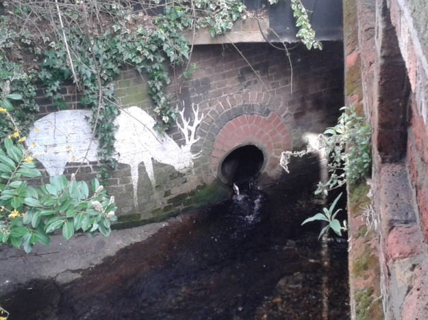
About a hundred metres on, we reach the Quaggy – another three way boundary in 1893 with Eltham replacing Kidbrooke. There is another boundary marker by the bridge over the Quaggy, its a defaced one of a similar style to that at the beginning of this section – rumour has it that the places were hacked out so as not to offer any help to German troops in the event of an invasion. There is though a better boundary marker almost below it though; by the outflow of the culverted Mid Kid Brook which as it joins the Quaggy is another Lewisham Natureman stag. This is the final one in the quartet of stags we have spotted on or close to the Lee boundary, so it seems an appropriate place to finish the circuit.
Notes

  1. Neil Rhind (forthcoming) Blackheath and Its Environs Volume 3

The Postcards are via eBay from 2016, apart from the one of Christ Church which is from a couple of years before.

Census and related data is via Find My Past (subscription required)

This, and the rest of the series of posts on the Lee boundary, would probably not have happened without Mike Horne, he was the go-to person on London’s boundary markers; he had catalogued almost all of them in a series of documents. He was always helpful, enthusiastic and patient. He died of a heart attack in March but would have loved my ‘find’ of a London County Council marker in some undergrowth on Blackheath during 2020’s lockdown, and would have patiently explained the details of several others he knew to me. A sad loss, there is a lovely series of tributes to him via this link.

Beating the Bounds of Lee, Part 7- Lewisham to Blackheath

During the first 2020 Coronavirus lockdown Running Past followed the long thin boundary of Victorian Lee before it was subsumed into Lewisham, aided only by a Second Edition Ordnance Survey map. This was in stages, from Lee Green to Winn Road, appropriately passing Corona Road en route; the next through Grove Park; then on through Marvels and Elmstead Woods and a Borough of Deptford Cemetery; the circuit skirted Chinbrook Meadows and followed the appropriately named stream Border Ditch; then another Ditch, Hither Green Ditch, more or less parallel to Verdant Lane and Manor Lane before following the Quaggy from Longhurst Road into Lewisham.

We’d left the 1893 boundary by St Stephens Church in Lewisham where the Quaggy is, or more likely was joined by Upper Kid Brook. When the stream was followed a few years back from its source around Hervey Road, on the lower slopes of Shooters Hill, there seemed no obvious evidence of flows coming into the Quaggy. The position was different in 1893 though, as we shall see.

The view looking towards St Stephens from what was captured in a postcard from slightly, although not much later; at the stage there were two confluences of the Quaggy and the Ravensbourne, the pictured Lewisham Bridge (an area a little later known as the Obelisk) and Plough Bridge by the former eponymous pub.

Even though Upper Kid Brook has disappeared from view, the course of the boundary and river is obvious from the valley. The valley though is not the shape that it had been until the 1840s as the North Kent Line, which opened in 1849 effectively stole the valley, deepening it in places.

There used to be a boundary marker on the curb on the northern side of St Stephen’s Grove, but it seems to have been lost at some stage. There is a slight dip in Lockmead Road, the remains of the fluvial erosion from the Brook, before the boundary hugs the rear fences of Cressingham Road, a boundary in terms of land ownership too. The Lee-Lewisham border comes out into 2020 public space in a relatively new development at the top of Cressingham Road. Looking towards the Brook and boundary from the railway underpass is a variation on a recurring theme from the circuit of Lee – a Lewisham Natureman stag.

In 1893, on the site of the new housing, was a small lake, the Brook was dammed to create it. The lake was at the end of the grounds of one of the large houses of Lee, Belmont, which gave its name to the Hill. it is mapped below. The house was built for the architect George Ledwell Taylor around 1830, when there would have been clear views to the dockyards of Deptford, where he worked for the Navy.

With the city encroaching and the railway passing, the large house ceased to be as desirable and was sold for the development of what turned out to be some of the most elegant Edwardian housing in Lewisham.

The Brook, and the Lewisham – Lee boundary drifted slightly to the north after he grounds of Belmont. By 1893 this was on the northern side of the railway around the end of what is now Belmont Grove. The railway is in a cutting within the valley, the pre-1849 level Brook and boundary would have been roughly at current road levels.

The railway had split the grounds of another of the large mansions of Lee, the Cedars – home in 1893 at to Ellen Penn, the widow of John Penn the eminent marine engineer. The northern portion of grounds had been laid out in the late 18th century for the then owner, Samuel Brandram, by the architect George Gwilt (1), who dammed Upper Kid Brook to form a pair of ornamental lakes, big enough for boating. Brandram was a paint and chemicals manufacturer and merchant whose large business was based in Rotherhithe.

The lakes were filled in by the next owners, Penfold’s whose carting business was to fill them with rubbish before selling the site on for housing development in the 1980s, now known as St Joseph’s Vale.

The boundary and Brook crossed Love Lane, now Heath Lane – part of an ancient path from Lee High Road to the Heath. In 1893, this area was still fields, with several boundary markers indicating on the ground the now hidden Brook. It wasn’t fields for long – within around 200 metres the fields turned to railway sidings, which extended another 600 metres up to the station, including the current car park.

The hidden street and boundary largely skirted the sidings – cutting across the late 1970s council housing of Nesbit Close and around the top of the current Perks Close. The Nesbit is E Nesbit who lived in various Lewisham locations, including a Blackheath home around half a mile away. Perks, of course, is a reference to Stationmaster of the Railway Children, played by Bernard Cribbins.

The boundary followed the edge of what is now Baizdon Road and then what is and was Collins Street. The former was named after a Blackheath miller, the latter after two mid 19th century Lee residents – Ann and Julia Collins (2). At the far end of Collins Street a boundary marker remains on a wall – the fence next to it seems to be the actual location of the Lee – Lewisham boundary.

The boundary continues following the building line to Blackheath Village; there was a three way boundary here Lee – Lewisham – Charlton. We’ll stop the circuit for now at a boundary marker, a replacement for one from 1903, when it would have been a Greenwich – Lewisham one.

Notes

  1. Neil Rhind (forthcoming) Blackheath and Its Environs Volume 3
  2. Joan Read (1990) Lewisham Street Names and Their Origins In the corner of the latter into the centre of Blackheath. – the area

The 1893 map which is used twice is via the National Library of Scotland on a non-commercial licence.

The Postcards are via eBay from 2016

This, and the rest of the series of posts on the Lee boundary, would probably not have happened without Mike Horne, he was the go-to person on London’s boundary markers; he had catalogued almost all of them in a series of documents. He was always helpful, enthusiastic and patient. He died of a heart attack in March but would have loved my ‘find’ of a London County Council marker in some undergrowth on Blackheath during 2020’s lockdown, and would have patiently explained the details of several others he knew to me. A sad loss, there is a lovely series of tributes to him via this link.

Beating the Bounds of Lee, Part 6 – Following the Quaggy

During the 2020 Coronavirus lockdown Running Past followed the long, thin boundary of Victorian Lee before it was subsumed into Lewisham in 1900, aided only by a 1893 Second Edition Ordnance Survey map. This has been in stages, from Lee Green to Winn Road, appropriately passing Corona Road en route; the second part took us through Grove Park, crossing the never built Ringway; we then passed through Marvels and Elmstead Woods and a Borough of Deptford Cemetery; the fourth part took us through Chinbrook Meadows appropriately following Border Ditch; and the last part followed the hidden stream Hither Green Ditch more or less parallel to Verdant Lane and Manor Lane.

We left the boundary at the confluence of Hither Green Ditch with the Quaggy to which we will return, following the red dots on the map.

The confluence has actually moved – in 1893 it was more or less where 49 Longhurst Road is now located; it is now around 40 metres away on a sharp corner between between Manor Park and Leahurst Road (pictured below).

In 1893 this was still, just, the land of Lee Manor Farm, although this would change dramatically over the next decade. As was the case when we followed the boundary along Hither Green Ditch, the Quaggy not only was the Lee – Lewisham boundary it was one between two farms. On the west was North Park Farm (the top of the map below) and on the east Lee Manor Farm – the sale of the former to Cameron Corbett who created what is known as the Corbett Estate and the latter by the Northbrooks in a more piecemeal fashion was to shape the urban landscape.

The boundary was within the flood plain, with the Quaggy meandering along the boundary of the farm, the Lee – Lewisham boundary of 1893. While this was acceptable in farmland it wasn’t in relation to the smaller suburban housing about to be developed the east of the railway. Memories of the devastating floods of 1878 will still have been prominent – the theory about dealing with such floods, which prevailed until the end of the following century, was to deepen and straighten the river, moving the water on as quickly as possible – this is clear from the photograph below. This approach also made development easier as had been seen with the development of Lampmead Road following the sale of Lee House in the 1880s.

Like the previous sections, the boundary is being followed on foot, the footwear of choice has changed though because while the rest of the route has been run, this section, apart from a 300 metre covered section in central Lewisham, is by walking along the river bed so waders became the footwear of choice.

The river and boundary continue to diverge for a little, the 1893 flow of the Quaggy and consequently the boundary meandered along what is now broadly Longhurst Road. It was never any more than 50 metres away from the river’s current, very straight, deep, engineered course. The convergence of the 19th boundary and the Quaggy more or less where the 21st century bridge from the the entrance from Longhurst Road into Manor Park is now situated – just above the start line for the annual (in non-COVID-19 years) Quaggy Duck Race.

While the Quaggy and Lee – Lewisham boundary are now coterminous and the meanders are broadly similar in 2020 to 1893, much changed in the intervening period. The Quaggy was straightened and channelised through what until the 1960s was the last bit of farming in Lee – a piggery. The open space, Manor Park, was created in the mid-1960s with meanders restored to something very close to those that existed in 1893 in 2007.

At the exit of the Park, there is a bridge, it is a long-standing crossing of the Quaggy, part of an ancient path known as Hocum Pocum Lane which ran from St Mary’s Church in Lewisham to Lee High Road. Despite the work done further upstream to deepen and straighten the course it flooded badly here in 1968.

Beyond Manor Park, the river and 1893 boundary squeezes between the Victorian housing of Weardale Road and Eastdown Park. The land for the latter land had already been developed by 1893, Eastdown Park on land that had been cultivated by the market gardens of Lewisham Nursery, run by Messrs Willmott and Chaundy, until 1860.

Beyond the river’s first meander is the garden of 45 Eastdown Park, possibly very briefly home to the Ginger Baker, his father was there just before the Cream drummer was born in 1939.  A hundred metres or so further on another there is another building with a musical history – the Rose of Lee, now Dirty South, which saw the first public performance by Kate Bush.

We have already mentioned serious flooding that occurred in the spring of 1878 in relation to straightening the Quaggy upstream.  However, while the meanders and boundary of Lewisham and Lee hadn’t changed since then, the depth of the watercourse had.  It is at least half a metre lower than in the prictue showing the partial destruction of the bridge in Eastdown Park.  So whilst it is a pleasant wander down the river there is little to see beyond boundary walls and banks for much of this stretch.

In 1893 on the opposite side of the Eastdown Park bridge was a Baptist Chapel, this was largely destroyed during World War 2 and the site is a vacant garage, last home to Penfold’s.

Both sides of the river and boundary into Lewisham were lined with housing in 1893; on the Lee (High Road) side a few remain, 152 was once home to William Sidery (pictured top) part of a multi generational Lee building firm.  Grove Cottage next to the Ambulance Station dates back to 1835 and 96 is the last remaining section of Lee Place (not to be confused with the eponymous mansion off Old Road) which was built in 1813 (lower picture) (1).

The remaining houses were largely lost to Fry’s garage and showrooms, which themsleves were replaced by a large Lidl and topped by an even larger block of flats this century.

On the opposite side of the river in Lewisham in 1893 was the well established College Park estate, briefly home to the poet James Elroy Flecker.

Behind the housing the river retains a pleasant almost rural feeling idlyll – it has probably changed very little in the 127 years since the Ordnance survey map being followed was surveyed.  

Beyond Clarendon Rise bridge, on the Lee side, was the Sultan in 1893 (pictured from early in the 20th century below), replaced in the last decade by Nandos; on the Lewisham side of the bridge is now the beautiful Hindu temple although that was a yard in 1893. Penfold’s moved into the site adjacent to both, known as Clarendon Yard around 1904.

The river disappears under what was referred to as Lee Bridge in 1893 for around 300 metres.  Alas, dear reader, this part was done at street level. 

The raised area above the river was an established shopping parade in 1896 with a tea dealer (83), a pair of boot makers (75 & 81), a wool shop (79), a confectioners with an architect and auctioneers above (77), Singer’s sewing machines (73), a stationers (71), a series of household goods shopsunder George Stroud’s ownership (65-69), a chemist (63), a florist (61) and the mainstay of that part of Lewisham high Street for generations – Chiesman’s Department Store (pictured a few years into the 20th century). 

Much has changed now, rather than Chiesmans dominating the street scene it is a massive and not particularly attractive police station. 

On the side of the police station is memorial that celebrates the contribution of Asquith Gibbes to Lewisham and, in the context of of the Black Lives Matter protests of earlier in lockdown, seems an important place to pause. Such memorials to members of London’s Black community remain a rarity, although just inside the Lee border is the Desmond Tutu Peace Garden, Tutu was a curate in Grove Park.

Asquith Gibbes was born in Grenada, and arrived in Britain in the late 1950s, working in Lewisham for 40 years fighting racial inequalities in education, policing and housing. There is a fuller biography of him as part of the brief for the memorial – two examples of his work have national significance. He chaired Millwall Anti-Racist Trust and instigated the ‘Kick it Out’ programme at Millwall Football Club in 1993, a campaign that was adopted nationally. Asquith was also part of very significant work with the Association of Chief Police Officers and the Home Office on reforming ‘stop and search’ rules.

Returning to the Lee – Lewisham boundary of 1893, the Quaggy re-emerges just beyond the shops of 1893 and the police station. The boundary though takes a sharp turn to the east (right) by St Stephen’s church, at what is/was the confluence of the Quaggy and Upper Kid Brook, following the latter towards Blackheath. We’ll cover that part of the boundary at our next visit.

Picture Credits

  • The picture of Chiesmans shop in Lewisham is via e Bay in June 2016
  • The photographs of 1968 floods, the destroyed bridge in Eastdown Park and the map of Lee Manor Farm are from the collection of Lewisham Archives and remain their copyright, but are used with their permission
  • The Ordnance Survey map of 1893 is via the National Library of Scotland on a non-commercial licence
  • The photograph of the Sultan is used with the permission of Robert Crawford, the great grandson of the Craddocks, licensees there in the 1920s, it remains his family’s copyright.

Note

1 Lewisham Leisure (1990) ‘From the Tiger to the Clocktower’

This, and the rest of the series of posts on the Lee boundary, would probably not have happened without Mike Horne, he was the go-to person on London’s boundary markers; he had catalogued almost all of them in a series of documents. He was always helpful, enthusiastic and patient. He died of a heart attack in March but would have loved my ‘find’ of a London County Council marker in some undergrowth on Blackheath during 2020’s lockdown, and would have patiently explained the details of several others he knew to me. A sad loss, there is a lovely series of tributes to him via this link.

Following the Quaggy – Manor Park to the Ravensbourne

We left the Quaggy just outside Manor Park having seen the park’s rejuvenation  from one of Lewisham’s worst bits of open space to one of its best, before that Running Past had followed the Quaggy from its sources around Locksbottom; then on through Petts Wood, the Hawkwood Estate, Chislehurst and Bickley, through the golf courses of Sundridge Park and on to Chinbrook Meadows; through the concrete and countryside of Mottingham; and then on through the playing fields and parkland of Sutcliffe Park and the Lee/Blackheath borders.
We left the river at an old crossing, although relatively new bridge that formed part of Hocum Pocum Lane; we continue along the Lane although it is now referred to as Weardale Road.  Unusually, it is visible for a short stretch as the western side of Weardale Road remains undeveloped, in spring it is a riot of colour from the plants that have colonised the banks.  The bridge is a great place for seeing the iridescent blue blur of the kingfisher – often sighted almost skimming the surface of the water, with occasional sightings of egrets and herons fishing in the shallows.
After 100 metres or so It bends sharply to the left, on the bend, in a tight triangular site, is almost certainly the finest modern building on the Quaggy – 22 Weardale Road – designed by and Anglo-Dutch architectural practice 31/44.
A little further on is the Rose of Lee pub, latterly called the Dirty South although it has gone through several names in the last 25 years.  It opened around 1900 and, perhaps, it’s greatest claim to fame was that it was the first venue that Kate Bush played.  It suffered damage and looting during the 2011 riots that spread across numerous locations in London in early August, it looked as though it was to become another lost Lewisham pub.  There were occasional signs of life and a few drinkers during 2016, but it took until 2017 to have a major revamp and re-open as the Dirty South in late October 2017.
Around here the Quaggy was once joined by Mid Kid Brook which used to flow  more or less alongside Lee High Road from close to Lee Green, its former valley is clear in places.  However, it was diverted to follow Lee Road to Lee Green, probably around the early 18th century.
The river is bridged by Eastdown Park, a bridge that was partially destroyed in a flooding in 1878 in an era when flooding seemed more common.
On the west side of f the Eastdown Park bridge (to the left of the photograph) is currently Penfolds garage – the remaining part of a company that used to have three bases locally, including taking over Lee Picture Palace as a car showroom in the 1970s. The usage of the site, which used to be home to a Baptist Chapel (below – source eBay April 2016), is about to change again – this time to flats.
The river follows a tight channel, built on both sides, occasionally over it – such as by KwikFit. The banks had been almost rural on the south-eastern side of until the College Park Estate in the late 1860s as the map below shows (on a Creative Commons from the National Library of Scotland).
By the next bridge, over Clarendon Rise, is without a doubt the most attractive riverside building on The Quaggy, a Hindu Temple, the London Sivan Kovil.  In September each year it is the venue for probably the most stunningly beautiful site in Lewisham – the Chariot Festival.
Attempts continue to be made either side of the Clarendon Road bridge to slow down flows through artificial meanders, while this allows some of the normal fluvial erosion and depositions on rivers in their natural state and thus will help a little with plant growth, it will be of little use in high flows though.
Soon after Clarendon Rise, just behind Lewis Grove, the Quaggy is covered at what used to be known as Lee Bridge.  Like much of the area upstream this too was liable to flooding – on an earlier Facebook thread on the river further upstream there were stories of what was then the Midland Bank (postcard from eBay September 2016) flooding in and notes floating around the flooded basement of the bank.
Historically, flooding was very common around Lee Bridge, this 1968 photograph, outside the Odeon (formerly Gaumont) Cinema commonly shown in relation to Lewisham flooding will probably relate to both the Quaggy and  Ravensbourne though – see comments below.
The extent of the covering of the Quaggy has varied over time, the recent development of the police station offered an opportunity to extend its visibility but it wasn’t taken and there is less of the Quaggy open now than there was a century ago as the postcard below shows (source – eBay February 2016).
The river currently re-emerges in front of St Stephen’s church, having first been joined by Upper Kid Brook. There used to be two arms to the Quaggy at this point – one by the former Roebuck pub, the second by the former Plough as the map below shows ( (Image on a Creative Commons from the National Library of Scotland). Both pubs disappeared in the early 2000s, as part of the redevelopment of Lewisham town centre.
The river broadly follows the course by the former Plough Bridge (left photo above) but at the time of writing, the confluence with the Ravensbourne is hidden in the middle of the Lewisham Gateway development which has rendered the area around the station almost unrecognisable.  Eventually, the confluence with the Ravensbourne will be in a small park, Confluence Place, but it may be a wait until the reality is anywhere near the architect’s impression.

In Search of Upper Kid Brook

Logically this post should start at the beginning but there is no scenic setting for the source of the Upper Kid Brook, and I don’t want to put readers off so the end, the outflow, must be the beginning on this occasion – alongside the St Stephen’s Church, Lewisham.

20140528-220206-79326171.jpg
Its architect was George Gilbert Scott, better known for his gothic revival work, such as St Giles, Camberwell, and the St Pancras hotel and station. St Stephens is somewhat different

thirteenth-century, with some French details – ‘eclecticism of a chastened kind, and the union in some degree of the merits of the different styles’

But as rivers should be followed downstream, it is back to the beginning in what used to be a marshy area in north east corner in bend of Hervey Road at the junction with Begbie Road, close to the lower end of Shooters Hill Road. There is nothing tangible to see of the Brook around here, there are upstream pointing contour lines of the Ordnance Survey 1:25,000 map at 40 metres, close to the north western corner of the playing field between Begbie Road and Wricklemarsh Road.

20140528-220541-79541471.jpg
Eastbrook Road has a perceptible dip, just behind the fallen tree in the photo, a likely pointer to the Brook’s original course.

The 35 metre OS map contour clue is in the gardens of homes close to the south eastern side of the Kidbrooke Grove and Kidbrooke Gardens. On the ground another distinguishable dip on Kidbrooke Grove and the Victorian ‘Brook House’ offer further hints as to the course.

To the west of Kidbrooke Grove there are some man-made signs of the course of the still underground the Brook (it was apparently piped underground around here at the time the railway was built in 1849) – old boundary markers that followed the Brook are alongside the path bordering Morden College on a narrow fenced off green strip of grass. This ‘strip’ is clear from the OS map too as the ‘valley’ marked by the 35 metre contour is around 25 metres wide centring on the path.

20140528-221812-80292943.jpg
There is more of the same at the front of Morden College as the contours and boundary markers cuts across its grounds – there is a marker on their front lawn and then another against the far wall of the Lodge.

The next few metres of the route are easy to work out; the ground drops away quickly to the east of the Paragon. Perhaps once the Brook babbled and tumbled down a series of small waterfalls in some pastoral idyll, but the current reality is a little less bucolic, it is almost certainly the same as much of the route so far – at best, a buried pipe.

20140528-223551-81351968.jpg
Behind the Paragon the Brook flows through the Fulthorp Road estate, named after a 15the century landowner, the land was compulsorily purchased by Greenwich Council after WW2 and was the first council housing within the Cator Estate in1954 using a neo-Georgian style to try to fit in with the surrounding architecture.

The Brook used to supply a pond on the imaginatively named Pond Road, which formed a reservoir for the Wricklemarsh Estate.

While the pond is long gone, its western side is clearly demarked by the low boundary wall. The Brook’s course was to the west south west from the pond, although this may well have changed once it was diverted underground.

20140528-222909-80949531.jpg

Below the Pond there were considerable problems with winter flooding due to heavy rain and snow melt with flooding of up to three feet (one metre) reported around the current centre of the ‘village’ (1). One of the methods used to try to alleviate the problem was the creation of a series of small reservoirs – the biggest of which was known as The Canal and was behind the current Blackheath Grove. The water was used to irrigate Hally’s Nursery there in the late 18th and early 19th centuries (2).

There had been an attempt to alter the course of the Brook in the dip in ‘The Village’, which was then referred to as Dowager’s Bottom (orHole), in the early 18th century by Gregory Page, owner of Wricklemarsh. It was perhaps an early attempt to deal with flooding problems, but Page was ordered by a court at the Green Man on Blackheath Hill to restore the line of the stream or pay a penalty of £10 (3).

The Brook’s valley was taken over by the North Kent Railway from 1849 and the Brook itself hidden from view. It flowed along the back of what is now Blackheath Grove, under the Post Office then crossing Tranquil Vale opposite the entrance to the station car park. The old boundaries would have it flowing just north of the car park, which was once railway sidings, but Edith’s Streets suggests a re-routing at this point to allow housing. It may actually have been buried under the tracks at this point, there are suggestions that after heavy rain it can be heard whilst waiting on the platforms, this may of course be just wishful thinking ….

There was frequent flooding from the Brook in this area too; Neil Rhind’s excellent book on Blackheath, refers to clearing them being a task for the Hollis family, who lived in former cottages in Tranquil Vale (4).

Its former route of the Brook is almost certainly hidden beneath the 1970s Lewisham council housing of Hurren Close, and then crossing Heath Lane (formerly Lovers Lane) to St Jospeh’s Vale.

Just before this point, there may have been a small tributary joining the Brook, there is a small valley clear on OS maps, starting around The Orchard on the Heath, as well as an obvious dip in Eliot Vale, the course would have then broadly followed Baizdon Road to the Brook.

image


The 1894 large scale OS map has the Brook feeding two small lakes, one complete with a boating house, which were part of the estate of The Cedars on Belmont Hill. There are upstream pointing 20 metre contours line is at the south western edge of St Josephs Vale.

20140528-225212-82332218.jpg
(Alan Godfrey 1894 Blackheath and Greenwich Park)
The course then cuts to the other side of the railway around the bottom of Belmont Grove, where not to be outdone by their neighbours, the owners of Belmont, another large house on Belmont Hill also had a small lake fed by the Brook. Belmont was where roads such as Boyne and Caterham Roads now sit.

The lake has long since gone; most recently covered by a housing association development whose service road, at the top of Cressingham Road, the Brook follows. It continues through the back gardens between Cressingham and Boyne Roads. There is another tell-tale dip in the road in Lockmeade Road before following St Stephens Grove for the last 100 metres or so to The Quaggy.

There used to be an old boundary stone that marked the outflow point just south of St Stephen’s Church, but this may have disappeared with the development of the police station. Unlike the Mid Kid Brook, even the outflow isn’t that obvious – there are three pipes above the channelised bank of The Quaggy which all flowed in the rain but were water free on a dry day.

20140528-223018-81018556.jpg


Notes

1 Rhind, N (1976) Blackheath Village and Environs 1790 to 1970 (Bookshop Blackheath Ltd.) p71
2 ibid p71
3 ibid p67
4 ibid p105