Tag Archives: Grove Park Ditch

Beating the Bounds of Lee, Part 3 – through Grove Park

During the COVID-19 lockdown Running Past has been following the boundary of Victorian Lee a few years before it was subsumed into Lewisham, aided only by a Second Edition Ordnance Survey map and a smattering of knowledge of the area. The previous two posts have taken us in stages, from Lee Green to Winn Road, appropriately passing Corona Road en route; the second took us On through Grove Park, crossing the never built Ringway, We’d left the boundary on Grove Park Road, on top of a culverted Grove Park Ditch, with a marker that had been weathered beyond any potential to decipher.  

For the pedants of periphery, the boundary marker is no longer on the boundary, in adjusting it to the rear fences of Marvels Lane it has led to the now Bromley – Lewisham boundary dog legging down the middle of Grove Park Road, the small sign of the former and the larger one of the latter announce the changes.  

The route followed in this section was entirely rural in 1893 as the Ordnance Survey map below shows with the Morse code dot dash line – although the most southerly end of Victorian Lee, the largely John Pound developed ‘new town’ of Grove Park is visible to the north east.

One the opposite side of Grove Park Road is the attractive Chinbrook Estate, built by the Greater London  Council (GLC) in the early 1960s; it is a development that has been covered by the 21st century’s foremost chronicler of council housing, Municipal Dreams, who noted 

“What was exceptional ….is the overall architectural and design quality of the Estate…..Chinbrook is a reminder of the best that might be achieved with proper investment and careful planning.”

Like the much larger Downham estate, which we will encounter further along the Lee boundary, it is an estate that straddles a boundary, Mottingham to the east, Lee to the west in 1893, at least.  The 21st century boundary is slightly different and is a currently  a Lewisham to Bromley one, The divisions aren’t immediately obvious, but as with Upwood Road further back, while there are no boundary stones, the  21st century markers are clear.  Along with the Borough colour coded bins, the Borough street signage indicates the location – white on blue for Lewisham, white on green for Bromley (plus some faded black on white signage, perhaps from the GLC era).

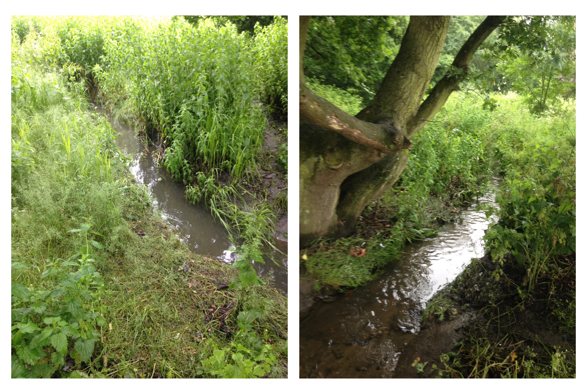
Back in 1893 there was a boundary marker close to where Grove Park Ditch now enters its long culvert on the edge of the estate; if it is still there, it is lost in the dense undergrowth.  Whilst the border probably ought to have followed Grove Park Ditch it doesn’t and seems to have followed field and probably ownership boundaries.  So the border follows what is now a fence between the attractive Lower Marvels Wood and the rear gardens of Grace Close.  The name coming from ‘W G’ who lived both in Mottingham and Sydenham. The estate provides links to other Lewisham sporting greats, Henry Cooper Way and Lions (Millwall’s nickname) Close. 

Over Dunkery Road, the 2020 boundary has been slightly amended compared with its late Victorian counterpart to cope with the slight dog leg of Duddington Close. There has also been a slight adjustment to for the 1930s council housing of Bilsby Grove.

The late Victorian boundary of Lee was at the border between the woodland of Marvels Wood and farmland.  The woodland remains but behind the council housing of Charminster Road the former fields have become Grove Park Cemetery.  It was an out of town burial solution by the Borough of Deptford whose main burial ground, Brockley Cemetery, was almost full by the early 1930s.  Running Past has covered Brockley Cemetery several times in the past, notably in relation to the murder of Jane Clouson who was buried there in the 1870s and has a large memorial.

Grove Park Cemetery was designed by their Borough Surveyor H Morley Lawson and ‘juxtaposed formal and informal elements and the cemetery buildings showed the influence of Moderne and Art Deco style.’  It was used from 1935.

From Bromley side of the boundary, the cemetery is largely hidden, albeit rather attractively by a hundred metre long mural by the seemingly now defunct Onit Design. At the top of the hill, within a metre of the boundary there is some even more impressive artwork, a chainsaw carving by Will Lee, which seems somewhat apt when following the Lee boundary.  There is some more of his work about 100 metres into the woods.

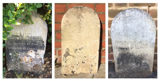
A couple of metres further on there is a very weathered boundary marker which in the Victorian Ordnance Survey map was a three way marker for Lee, Mottingham and Bromley; now the bigger London Boroughs of Bromley and Lewisham.  A metre or two along the path is another, hard to spot boundary marker, just inside the heavy duty palisade fencing ‘protecting’ the cemetery from the Green Chain Walk in what is now Elmstead Woods. It is unusual in the that it marks the direction of the boundary, located as it is on an angle.  The direction is incorrect as it appears that the marker was moved at the time of construction of the cemetery and unintentionally rotated by 90°.

The 1893 boundary darted easterly across the fields  towards Grove Park, the current variant, dating from 1991, is a little more circuitous and reflects the ownership of the cemetery and skirts its border.

There was, and probably still is, another marker at the eastern edge of the cemetery. However, in the very dense undergrowth it proved impossible to find amidst the brambles and nettles (poor companions for a short-clad runner).  All was not lost though, there was a marker of sorts – a Lewisham bollard, marking the  boundary of car park and Green Chain Walk.

Over the car park the Victorian boundary followed the northern edge of what are now allotments – we’ll leave the boundary there for a while before we go through Chinbrook and on to the edge of the Downham Estate.  

Credits and Thanks

The Ordnance Survey map is via the National Library of Scotland on a non-commercial licence.

The series of posts on the Lee boundary that this post is part of, would probably not have happened without Mike Horne, he was the go-to person on London’s boundary markers; he had catalogued almost all of them in a series of documents. He was always helpful, enthusiastic and patient. He died of a heart attack in March but would have loved my ‘find’ of a London County Council marker in some undergrowth on Blackheath during 2020’s lockdown, and would have patiently explained the details of several others he knew to me. A sad loss, there is a lovely series of tributes to him via this link.

Beating The Bounds of Lee Part 2 – Winn Road to Grove Park

In the last post, we returned to the old tradition of ‘beating the bounds’ of the civil parish of Lee, ‘armed’ mainly with a Second Edition Ordnance Survey map of the area and a decent amount of local knowledge of the history. The survey for the map had been carried out in 1893, but it seems to have updated to reflect boundary changes relating to Mottingham in 1894.

We had left the Lee boundary on Winn Road, part of a small estate developed by William Winn, which, appropriately for the time this post was written, includes Corona Road.

The route followed is the red line on adjacent Ordnance Survey map. It was broadly the same circuit that had been followed in 1822 by the great and the good of the parish. Included in their number, although not in the ‘good’ part, was the final tenant of Lee Place, the odious Benjamin Aislabie – a slave owner after slavery was abolished in the Empire. At least the parish spelled his name incorrectly as ‘Aislibie’ when naming a street after him.

This image has an empty alt attribute; its file name is af0690cd-be10-40de-8e36-558916f75f88.jpeg

We had left the boundary at the final of a trio of 1903 Lewisham boundary markers at the south easterly junction of Winn and Guibal Roads. Lee was merged with Lewisham into the Borough of Lewisham in 1900. The 1893 boundary was about 15 metres to the west and cut across to what is now Burnt Ash Pond, mid way down Melrose Close. The current Lewisham boundary with Greenwich veers off to the east down Winn Road to the Quaggy.

Burnt Ash Pond is usually a delightful little oasis of calm, but seemed to be suffering from lock down, seemingly covered with either duckweed or green algae when passed by on this occasion. The 1893 variant of the boundary passed through the Pond and continued southwards down Melrose Close, attractive late 1970s council housing, diminished by an entrance through largely abandoned garages. In 1893 the boundary passed through back gardens parallel to Burnt Ash Hill, almost opposite College Farm. There is an 1865 Lee Parish marker hidden in the undergrowth next to the pond, although it is not visible from the outside.

The name ‘Melrose’ came from another farm which seems to have evolved out of Horn Park Farm, whose farm yard we crossed in the first post, and was essentially a market garden operation and was also referred to as Woodman’s Farm, after its tenants. The Close was probably part of its land. Its farmhouse in Ashdale Road remains and was used as a site office for the developers of much of the area we are about to pass through, Wates. The farm’s main claim to fame was the unintentional landing of Willows II (pictured below) which was aiming for Crystal Palace and in the process created a record for the longest airship flight.

This image has an empty alt attribute; its file name is image.jpeg


The boundary continues parallel to Burnt Ash Hill until a point almost opposite Ashwater Road when it follows what are now the rear fences of houses on the northern side of Senlac Road, presumably named after the likely location of the Battle of Hastings. In the back garden of a group of Wates built interwar semis between Exford and Ashdale Roads, there was once the junction of the parishes of Lee, Eltham and Mottingham. The house with three boundaries, then had two and now has none – the Bromley boundary is now at the bottom of the hill following the Quaggy. The change is a relatively recent one, dating from 1991 proposals, the current resident remembers paying council tax to both Lewisham and Bromley. In 1893 we would have been in fields.

The 1893 boundary broadly followed what is now an access road to the rear of houses in Jevington Road. The end of Jevington Road has a chain link fronted jungle facing it, the boundary pierces through the chain link, on the Mottingham side of the 19th century border is now a Den of a former Dragon, a Bannatyne Health Club. The Lee side is, arguably even healthier – some allotments, along with a community volunteer run library.

This image has an empty alt attribute; its file name is c184c1fd-fb72-4fc1-aba9-0217594ac8ee.jpeg

This section would have been very different if the Conservative run Greater London Council (GLC) plans for Ringway 2 had come to fruition in the late 1960s. In South London, it was essentially a motorway replacement for the South Circular.

There was much secrecy about the detail of the route, although the most likely version suggested by Chris Marshall would have seen a five lane motorway driven through the allotments, with a minor interchange for Burnt Ash Hill and a major one on Baring Road. There was much opposition across south London to the scheme, and the absence of a motorway here points to its success. The only tangible remains of Ringway in the area is an eponymous community centre on Baring Road.

Returning to 1893, when the Ordnance Survey cartographers visited, the Grove Park Hospital had yet to be built – that wouldn’t be for another 15 years. We’ve covered the hospital when we followed the Quaggy through these parts.

On the northern wall is a boundary marker – the ‘MP’ is clear in that it relates to Mottingham Parish which from 1894 to 1934 was a ‘detached’ part of the Bromley Rural District. The ‘LP’ is less clear, Lee had disappeared into Lewisham by the time the hospital was built, but it was the Borough of Lewisham rather than the parish.

In 1893 the parish of Lee meandered across the soon to be hospital site, changing direction at a tree that doubled up as a boundary marker. The tree is long gone, presumably felled when the hospital was constructed and the boundary moved to the edge of the hospital site. Oddly, in the housing that replaced most of the hospital buildings, there is a tree at the same point as the former boundary marker.

On the eastern side of the hospital site, Lee’s boundary takes on a new format, the Quaggy. Rivers and streams often form the boundaries between parishes and local authorities, as we have found with several streams and rivers – including the River Wilmore in Penge and Border Ditch that we will encounter later in our perambulation around Lee.

Alas, the conterminous boundary with the Quaggy (shown top left below) only lasts for around 50 metres, about 2 and a half chains of Victorian measurement. However, we swap one watercourse for another as the boundary veers off the the east, following Grove Park Ditch, which depending on rainfall levels either cascades or splutters into the Quaggy (top right, below).

The confluence is a pipe opposite the Sydenham Cottages Nature Reserve, named after the farm workers cottages above. The nomenclature ‘Ditch’ is used quite a lot within the Quaggy catchment, it shouldn’t be seen as belittling or derogatory it is just the way smaller streams are described – there also are Milk StreetBorder and Petts Wood further upstream.

About 50 metres inside the Lee side of the boundary, Lewisham Natureman has been recently active – a new stag has been painted, drinking from the Quaggy (or would be in more typical flows) in the shade of an elder bush. We will return to his work at a few other points on our travels around the Lee boundary.

The course of Grove Park Ditch isn’t certain, it is culverted for almost half a mile, but would have crossed the fields below more or less parallel to a very rural looking Marvels Lane from 1914, presumably coterminous with the boundary.

There is a boundary marker outside 94 Grove Park Road. It is weathered and unreadable, but marks the Lee boundary with Mottingham – given the style is similar to those around Winn Road at the beginning of this section it probably dates from 1903, however, the location of the boundary was the same in 1893.

In the next instalment, we will follow the boundary through the rural Grove Park of 1893.

Picture Credits

  • The Ordnance Survey Map is via the National Library of Scotland, it is used here on a non-commercial licence
  • The picture of Willows II is from an original postcard in the authors ‘collection’
  • The Ringway map comes from Chris Marshall’s fascinating website
  • The postcard of Grove Park is from e Bay in November 2016

The series of posts on the Lee boundary that this post is part of, would probably not have happened without Mike Horne, he was the go-to person on London’s boundary markers; he had catalogued almost all of them in a series of documents. He was always helpful, enthusiastic and patient. He died of a heart attack in March but would have loved my ‘find’ of a London County Council marker in some undergrowth on Blackheath during 2020’s lockdown, and would have patiently explained the details of several others he knew to me. A sad loss, there is a lovely series of tributes to him via this link.

Following the Quaggy – Chinbrook Meadows to Eltham Bridge

In previous posts, Running Past has followed the Quaggy from its sources around Locksbottom and then on through Petts Wood, the Hawkwood Estate, Chislehurst and Bickley and through the golf courses of Sundridge Park and on to Chinbrook Meadows.

We left the Quaggy in a concrete channel coming out of Chinbrook Meadows.  A small weir lowers the level of the river bed as it exits the park, it is not to provide a more natural bed though, the notched river bed gives way to a flat one but it is still concrete – attempting to quickly move the water on, as was de-rigour in the 1960s.  The river isn’t completely barren at this point – some small plants are clinging onto an existence but struggling to put down any roots.

image

It is in a clear valley as it crosses Chinbrook Road, with climbs up to both Grove Park Station and the Grove Park and Chinbrook housing estates (both covered by the excellent Municipal Dreams blog).  But that is about as natural as it gets – while the shape of the banks and the bed change the concrete seems to remain as the Green Chain Path follows its eastern bank, it is a path that it marked on early Ordnance Survey maps (on a Creative Commons from the National Library of Scotland)


OS Claypit.png

The path emerges out onto what used to be called Claypit Lane but is now called Marvels Lane.  The road is bridged and heads towards the entrance to some playing fields – this isn’t how it has always been though.  As the Ordnance Survey map above from the 1890s shows, there used to be a small pool and a distinct meander at this point – taking  the Quaggy in front of the former agricultural workers cottages – Sydenham Cottages (below) – presumably for Claypit Farm (just off map, although no longer marked by the 1890s).

image

There was serious flooding there – notably in 1968 – which seems to have led the channelisation and straightening of the river.  The Quaggy encased in concrete is now more or less devoid of life at this point.  Its former meander is now the Sydenham Cottages nature reserve which despite its river bank location has almost no trace of wetland habitat remaining.

The straight channel is slightly disturbed opposite the nature reserve with a concrete access ramp (see above left photograph) – this has led to some fluvial deposits in the slowest moving bits of the river.  Plants have colonised the sediments, but it is a precarious existence, without deep roots, they could be lost to the next high flow.

Opposite the nature reserve, and clearly visible from it is the outflow, just above the river level, one of the tributary streams joins the Quaggy, Grove Park Ditch – which rises in Marvels Wood and has an attractive 400 metres through woodland and park edge before being forcibly submerged around the edge of the Chinbrook Estate and then the playing fields of the former Fairy Hall – which gave its name to another stream in the Quaggy catchment, Fairy Hall Flow.

The river is followed by the Green Chain Path for another hundred metres or so before the path veers off to the right towards Mottingham Lane and the last home of WG Grace.  For those following the river as a walk this is the way to head and then re-join the Quaggy near at the junction with Winns Avenue.

For most of the 20th Century the former over spill Greenwich Union Workhouse, Grove Park Hospital, dominated the area – its land went up to the banks of the Quaggy – the slight valley is clear from the postcard below (source eBay November 2016).

grove park 1914

The location both as a workhouse and in its early days as a hospital, led to its under use as it away from the urban area.  It spent time as a military barracks and hospital during World War 1 ( see post card below – eBay May 2016) but was a TB and chest hospital for most of its ‘life’, although latterly became a mental health institution – the development of care in the community and associated hospital closure programme meant that its days were numbered.  It closed in 1994 and is now a mixture of a private health club and housing.

grove PArk 1915

There used to be a second meander, in what were the grounds of Grove Park Hospital but that too was removed presumably at the same time as that of Sydenham Cottages.  The meander is easy to see on the ground, next to the former hospital is a private leisure centre through whose ground there is access to a scrubby field that gently slopes down to the river, the path to it, which traverses a broken down bit of chain link fencing, is easy to miss though.  The former meander is a jungle of brambles which proved something of an obstacle to the bare-legged urban explorer.  A little further along the path that loops around the unkempt grass, the Quaggy is reachable and seems almost back to its semi-rural state last seen on Tong Farm, several miles back upstream.  It is but a brief interlude though – the Wates developed houses on the former Melrose Farm soon appear on the western bank and the river is left to flow behind the gardens of Westdene Avenue and Jevington Way.

image

On the eastern bank is Hadlow College, which was once the site of a large Victorian house, Mottingham Hall.  For a while, the site was the Macintyre Nature Reserve – part of an organisation that provided support for people with mental health disabilities, it then became an outpost of Phoebes Garden Centre, before being taking on by Hadlow College.  Contours would suggest that there may have been at least one stream joining the Quaggy in this area.

image

The Quaggy emerges into the public gaze by the side of the entrance to the College, still with natural banks, although one is lost as it hugs the side of Mottingham Lane before flowing through a shiny new screen to prevent blockages in a section under the Lane.  The opposite side of the road is then meandered against, with the fields of Mottingham Riding School on the other side, before a confluence with one of the Quaggy’s larger tributaries, the Little Quaggy close to the Sidcup by-pass (below, right.)

image

In several Facebook threads there are memories of playing in the river in this area, catching sticklebacks and taking them home in jam jars, going through the underground sections of the river both under Mottingham Lane and the braver ones under the A20. Others used to play ‘Quaggy jumping’ in this area near the now closed Dutch House pub. ‘It was always a triumph when you reached the other side without getting wet shoes, good days.’

image

Any feelings of ‘rus in urbe’ are soon lost after crossing the A20, while edged by grass and trees on initially scrubland and then a series of sports grounds, the concrete bed and banks return in their bleakest form anywhere on the river, any remaining sticklebacks would be hard pressed to find food.  The concrete course is almost as straight as a Roman road as it bypasses playing fields including the new home of Greenwich Borough FC, whose previous permanent ground, Harrow Meadow, adjacent to the Quaggy in Sutcliffe Park was lost to developers in 2009 – and they had a nomadic existence for a few years.  On the opposite bank, until the early 1930s, would have been the Middle Park Farm – like Horn Park Farm it was originally site one of the Eltham Palace’s hunting parks.

The river then squeezes between back gardens and is bridged the South Circular – on the south side it is shielded by a wall of a height that makes visibility of the flow impossible; on the northern side while the parapet was lower the overhanging shrub on both sides of the river meant that the flow was still invisible. It emerges back into the open at Eltham Bridge.  This is an area that is still subject to flooding – over 20 houses were flooded around Christmas 2013.  Before leaving the Quaggy there for another day a stop at the Bridge is worth making; it has an old London County Council sign with a wide variety of rules relating to bridges it controlled up until 1965.  Mooring a vessel at Eltham Bridge would be quite challenging though …..

image

Beyond a Boundary – Border Ditch, a Quaggy Tributary

Border Ditch is one of the smaller tributaries of the Quaggy – it rises in playing fields on the edge of the Downham estate, very close to a natural boundary – the watershed that marks the divide between the Quaggy and Ravensbourne catchments. Its name comes from a different boundary though – for some of its recent life it was a small part of the border between Lee, then Lewisham, and Bromley.  In addition, it would mark the limit of London until 1965 when Bromley was prised out of Kent and brought into the metropolis (although the distinctions had become a little blurred from the 1840s as the Bromley was included in the area covered by the Metropolitan Police).

While the contour lines on the map for the early part of the Ditch are clear, they would suggest a route from around the middle of the playing field then following a line slightly to the south of Welbeck Avenue to Burnt Ash Lane.  However, the boundary which predated development, and the playing fields, is slightly to the north of this, suggesting that the course may have been adjusted when the land was farmed.  There was no access to the school playing fields, so any further investigation proved impossible.  The current course seems to follow a now overgrown access road to garages and then a very clear dip in Burnt Ash Lane.

image

There used to be a small bridge at this point which was captured on film around the time of the First World War, before the advance of suburbia and the Downham estate in the 1920s (source Lewisham Archives on a Creative Commons).

border-ditch

The stream is no longer visible (or even audible) at this point but there is a clear valley as it squeezes between the gardens of Ridgeway Close on the Bromley side and Wydeville Manor Road on the Lewisham side.  There are tracks down to garages at the rear on the Bromley side, but as ‘danger reared its ugly head’ – with a dog starting to bark as I attempted to investigate – the urban explorer ‘turned and fled’ in the manner of Brave Sir Robin.

Fortunately, there was a dog-free access point on the Lewisham side and squeezing between some broken railings a view of the newly emergent Border Ditch was possible.  There is a noticeable valley although during a relatively dry early autumn relatively little water. From this point, it is likely that the Ditch continued downhill until it met the Quaggy; it isn’t possible to be certain though as the imposing railway embankment obliterated contour lines past.

image

Railway engineers appear to have taken the Ditch on a slightly more circuitous journey in creating a new confluence with the Quaggy. The course they chose for it would have seen the Ditch empty into the Quaggy close to the bridge in the southern part of Chinbrook Meadows – source Creative Commons.

border-ditch-2

While the line to Bromley North was later added, the course doesn’t seem to have altered – source Creative Commons, National Library of Scotland.

border-ditch-3

The stream seems to have been slightly moved north east at a later date to hug the edge of the embankment and emptying into the Quaggy just after the latter enters the tunnel under the main line.

The re-emergence into the open  is a rather desultory one, exiting from its concrete casing into what was more reminiscent of a drain than a stream.  There was little sign of movement in the ominous looking muddy water.  It wasn’t even easy to see, hidden behind stout metal Network Rail fencing preventing any ne’er do wells having access to the embankment from the south westerly part of Chinbrook Meadows.

image

The emergent Ditch trickles slightly downhill for almost a hundred metres towards its final destination – its confluence with the Quaggy.  The coming together of the flows is rather lacking in distinction too, there is a twist to force the Ditch down and almost back upon itself to meet the Quaggy with the all the force of a tap with low water pressure.  My failed attempts to photograph the junction were even less impressive than the reality.

image

The good news is that there are plans afoot to try to make the last few metres of the ‘Ditch’ slightly more alluring, while the aesthetics will be improved considerably, the real reason is to install a sustainable drainage system (SuDS) which would enable water to run through a series of pools planted with native marshland plants that will naturally filter the water reducing the potential pollution impact of the ‘Ditch.’  I am no expert on gauging water quality by sight, but it didn’t look good.

While Border Ditch isn’t currently worth much of a trek, Chinbrook Meadows is a different matter, it is a lovely park – one of my Lewisham favourites.  It was the site of a small dairy farm, Chinbrook Farm – the park first opening in 1929 and being considerably extended eight years later.  The Quaggy was channelised early in the ‘Meadow’s’ existence and, from memory, large fences and hedges partially hid the river (they still do on its exit).  The river was freed into a more natural gently meandering course with more natural planting and access after works that were completed in 2002.

© Derek Harper, Creative Commons

If you recognise some of the latter photos and text, that would not be surprising, I have previously attributed them to a different stream – one I referred to as Grove Park Ditch (West).  Border Ditch is referred to as that, without the locational suffix, by the Environment Agency. However, having spent an age following flows and contours on old OS Maps I am now pretty certain that the outflow is that of Border Ditch, I am in pretty good company here – my view is shared by the sadly departed fellow fluvial flâneur, Ken White.

The area is no stranger to artificial boundaries – around quarter of a mile away from the source of Border Ditch there was the infamous wall of Alexandra Crescent.  It was built by the developer of a private road in 1926 to prevent those on the Downham Estate being able to walk through the new middle class housing towards Bromley.  It never had planning permission, but the over two metre boundary, topped with broken glass was to last until 1950. (More information & picture source)

downham-wall

The Ordnance Survey note boundary markers both within the Chinbrook Meadows and at the bottom of Oakbrook Close.  They seem to no longer exist – I certainly couldn’t find them and they haven’t been spotted by a follower of the blog who is tracker of boundary markers – the earliest maps note they were on trees though so even if the trees are still there the marks probably won’t be – however, nowhere did I see any arboreal girth approaching 200 year years (a substantial tree in 1860 plus the intervening time period)…

Back to the Border Ditch, it is no longer the border for much its last few metres, the Local Government Boundary Commission agreed to requests from both Bromley and Lewisham to shift the boundary to the far side  of the railway in 1991.  The dashed line is the ‘new’ boundary; the non-dashed one the pre-1991 boundary.  So it seems that the watershed is probably the only definitely fixed boundary – boroughs and counties are man-made constructs and as we have seen even streams change course, in this case diverted at least.

border-ditch-4

The Stream with No Name – A Tributary of the Quaggy

Sometimes making sense of watercourses after the urban area has encroached upon them is not that straightforward, developers and railway engineers can confuse apparent flows in a way that make deciphering  a stream’s courses a little tricky. This is one such example.

This is a stream that fooled me – I had originally thought that this stream had gained length when suburbanisation arrived and had been taken on a geographically plausible, although unlikely, detour around the edge of two railway embankments to join the Quaggy in Chinbrook Meadows.  There was even the sound of subterranean running water just to confuse matters – it was probably just a drain …..

The source of my of confusion had been the Environment Agency referring to the outflow in Chinbrook Meadows as Grove Park Ditch, whereas the real Grove Park Ditch is, entirely separate, and, a few hundred metres to the east.  It was only when I started tracing Border Ditch that I realised their, and my, error.

Anyway, back to this small, unnamed stream …..

GPDW1

Its source seems to have been a pond, or the ground just above it, at the junction of what is now Leamington Avenue and Portland Road – the little bit of blue on the Ordnance Survey map published in 1898.  The stream’s route is clear from the Environment Agency Flood Risk maps, when the surface water option is selected – it is the thin blue line to the bottom right of the map.

GPDW2

image

The course is probably no more than 200 metres long, the upstream pointing contour lines of the modern 1:25,000 OS map show it heading from its original source (the left hand picture above), towards the Quaggy’s original course – behind Leamington Avenue, roughly following a now largely overgrown track to garages behind the houses (middle picture), then crossing Leamington Close, still under a track to garages (right hand photo above), to join the Quaggy behind where Oak Tree Gardens are now situated.

image

The Quaggy too was diverted underground in this area when the houses were built, there is a clear dip in Leamington Avenue (top photo immediately above) and its new submerged course is topped by another access track to garages.  Oddly, above where the confluence occurs there was a large puddle (above, lower photo), I did plan to take a slightly closer look but dogs barking on the private land as I approached rather deterred me – a less than intrepid explorer.

This stream ought to have a name now that it has been re-discovered  –  I would suggest the appellation Leamington Ditch for it –It needs to be a Ditch – it is the usual nomenclature for small streams around here.  However, Leamington merely comes from the street it runs parallel to for its short course – so would be happy for others to offer alternatives to whoever the appropriate arbiter for Ditch names.


An finally … thank you to Lawrence Beale Collins of Thames21 for helping me with unpicking the two very different Grove Park Ditches.

Grove Park Ditch – A Quaggy Tributary

As Running Past has noted before, little imagination went into the naming of most of the Quaggy’s tributaries, the notable exception being Mottingham’s Fairy Hall Flow.  Grove Park Ditch is one of those appellations that is lacking in allure, purely functional, mundanely descriptive – although, as we will find, it is in places much more than that.

Grove Park Ditch is a near neighbour of the seemingly no longer flowing Fairy Hall Flow, its source in Lower Marvels Wood is a couple of hundred metres away from where the Flow once babbled through farmland on what is now Beaconsfield Road.

The ‘source’ is in the lovely Lower Marvels Wood, presumably a remnant of the past woods that covered the area now part of the Green Chain Walk.

image

The amount of water at the source is impressive, and has eroded a relatively deep channel which was quite a slippery scramble to get down see.  It presumably isn’t the real source; there is a concrete construction around the ‘source’ with a just visible pipe curving off to the east – presumably water is culverted from somewhere else.  There are one or two small ponds marked on Victorian OS maps a little higher up the gently sloping hillside in Marvels Wood – they aren’t marked on modern maps and my limited exploration on a very soggy Sunday morning failed to find any sign of them.

image

After the initial erosion from the force of the water from the source, the ‘valley’ soon becomes imperceptible with the Ditch clinging to the southern edge of Lower Marvels Wood, almost hidden from the playing fields it borders.  For a small stream flowing through woodland and a park edge, it seems to ‘attract’ a vast quantity of urban debris, if the large pile by the plastics and glass by the traps close to Lambscroft Avenue is anything to go by – this is just before the Ditch is lost to view,

image

The ‘Ditch,’ once encased in concrete, heads down the gentle slope, under houses towards the playing fields of Eltham College.  The exact route is unclear; it isn’t marked on old OS maps as a stream.  However, as historical boundaries often followed natural features such as streams, it is quite likely that the original course marked the local government boundary from the highlighted boundary stone (on the map below) until it reached the Quaggy.  During my reconnoitre I didn’t hear the sounds of rushing water emanating from below manhole covers, however, this may have related more to the cacophony of the above ground torrential rain, with one or two thunderous rumbles, drowning out any subterranean sounds.

GPD1

Any access to the playing fields of Eltham College (Running Past  has ‘visited’ the former Fairy Hall before) and those of the City of London School is limited, the gates are locked and the borders are patrolled. So it wasn’t possible to see whether there was any above ground evidence of the Ditch, maps suggest there might be, although the satellite view of Google suggests that it is submerged, hidden just beyond the boundaries of cricket pitches.  The maps appear to show another small stream or drainage ditch too.

image

The outflow of Grove Park Ditch is a pipe from the wall of the horribly channelised Quaggy – the walls and river bed are concrete and presumably devoid of much life as a result.  As the Quaggy Action Group suggested a decade ago, it is a ‘suitable case of treatment’ of the kind that has enhanced both Chinbrook Meadows and Sutcliffe Park, both visually and in their ability to hold storm flows.  The outflow was easier to see than to photograph from the Green Chain Walk path, although this was largely because of the siling rain when I ‘explored’ for this post.

GPD2


While not part of the ‘Ditch’, on the western side of the Quaggy there is modern cartographic evidence of a couple of streams joining the Quaggy from the area around what is now Hadlow College, the Victorian OS map showing just the ponds, however, this too is private land and not accessible to the fluvial flâneur.