We’d started our circuit of Lee at Lee Green during the first 2020 Coronavirus lockdown and the last leg from Blackheath to Lee Green was under the not dissimilar conditions of lockdown 2.0 in the late autumn of 2020. In the intervening months, Running Past followed the long thin boundary of Victorian Lee just before it was subsumed into Lewisham in 1900. The navigation was aided by an 1893 surveyed Ordnance Survey map.
This circuit has been in seven stages up to this point, from Lee Green to Winn Road, passing a street whose residents probably now wish it had a different name – Corona Road; the next stage was through Grove Park; then on through Marvels and Elmstead Woods; the circuit skirted Chinbrook Meadows and followed the appropriately named stream Border Ditch; then another Ditch, Hither Green Ditch, more or less parallel to Verdant Lane and Manor Lane before following the Quaggy from Longhurst Road into Lewisham, then in the penultimate part following a Quaggy tributary, Upper Kid Brook to Blackheath.

We’d left the boundary at a T junction of borders, Lee – Lewisham – Charlton with a replacement of a 1903 boundary marker of a similar style to those seen in several places around the border.

The stone is next to the railway bridge and it is worth a quick turnaround by the first turning on the left, or would have been in 1893. A large Methodist chapel had been built in the mid-1860s and dominated the Blackheath Village skyline and was to do so for another 52 years until a V-2 rocket attack hit it in March 1945.
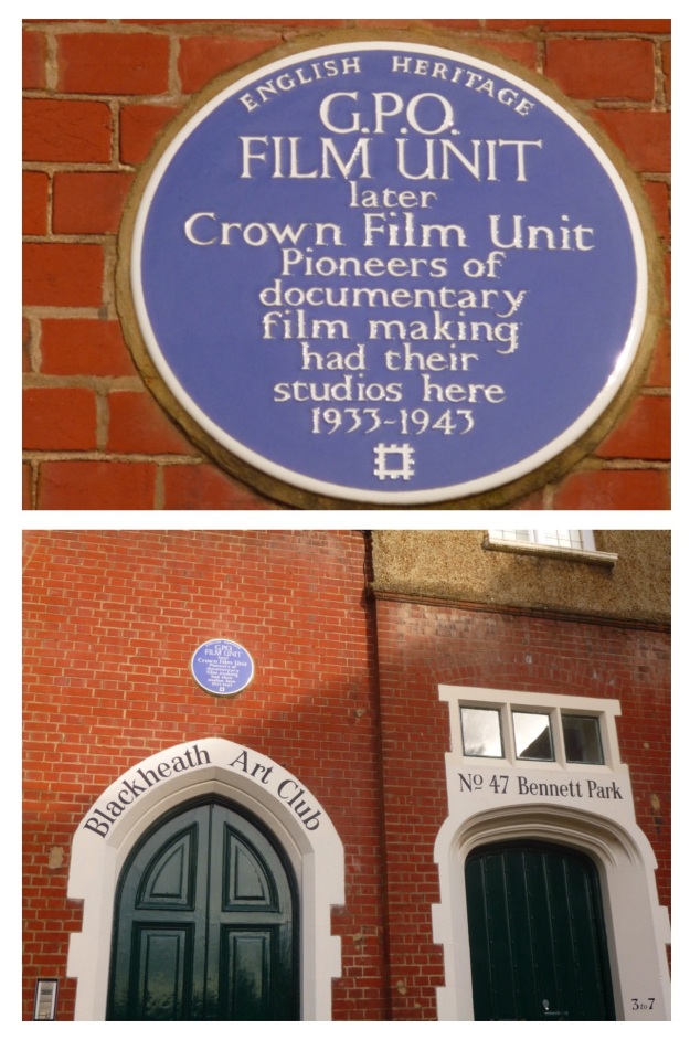
The turning is Bennett Park, which has one of biggest concentrations of blue plaques in south east London – the Physicist, Sir Arthur Eddington lived at number 4 – he was listed as a boarder there in the 1911 census, whilst working at the Royal Observatory. The cartoonist Donald McGill, lived at 5 Bennett Park – he was there when the 1939 Register was compiled. But, perhaps, the most significant is one at the far end for the GPO Film Unit, whose output included the wonderful film adaptation of W H Auden’s Night Mail, which featured a score by Benjamin Britten. The Film Unit also produced some World War Two propaganda films. The building had been partially funded by one the main benefactors of late Victorian Blackheath, William Webster, son of the eponymous main contractor of Joseph Bazlegette, as Blackheath Art Club.

Onwards and southwards, the boundary goes upwards and out of the valley of Upper Kid Brook towards the watershed with the adjacent Brook in the trio of Kid Brooks, Mid Kid Brook. Straddling the catchments is a pair of elegant buildings at the top of the hill – the Conservatoire of Music and Blackheath Concert Halls, again in part the paid for built by William Webster. Both were a few years away in 1893 though, there was a terrace of houses there at that stage. The Concert Halls, resplendent with some lovely pargeting, were to be the location of a badly disrupted suffragette meeting in 1909.

Lee Road, which we follow to Lee Green and the end of our circuit, had been farmland on the western side until 1835 (1) – this was a little later at the Lee Green end which in some years was the home to the annual horse racing of Lee Races. The eastern side, part of the Cator Estate, had seen some development from a couple of decades earlier. We won’t look at much of the housing here in any detail as Neil Rhind’s meticulously researched Blackheath Village and Environs Volumes 2 &3 cover this.

By 1893 though, this was wealthy suburbia and there was still farmland to the west. In the period since, the mix of housing has changed considerably – the area around corner of the Lee Road and Blackheath Park (pictured above from early in the 20th century) is perhaps, typical of them – with Victorian housing replaced by Span housing of which there are lots examples dotted around the Cator Estate (pictured from a similar location in 2020).

The Charlton – Lee boundary continued, unmarked, along the centre of Lee Road in 1893; on the western side the view would probably have been dominated by the Christ Church on Lee Park. The area had once been part of the parish of St Margaret’s but the burgeoning population saw the parish split several ways, Christ Church (pictured below from Lee Park) being the first to be carved out in the 1850s. It lasted until ten days into the Blitz when Luftwaffe bombs destroyed most of it with the remaining parts demolished before the end of the war.
The church wasn’t the only part of the urban landscape to suffer during the war. There was damage of sufficient volume for there to be two small estates of prefab bungalows – Lee Road Bungalows just to the north of what is now Heathlee Road and River Close, which was opposite Manor Way. The section between them and onwards to the south was re-developed in the 1960s. The postcard below shows the street scene in that part of Lee Road in the early 20th century looking towards Blackheath – the boundary going down the middle of the road.

Just to the north of Manor Way, there was another T junction of boundaries – Lee remained constant but on the eastern side Charlton became Kidbrooke. The 1893 Ordnance Survey map noted a boundary stone, but this alas is no longer there. The Charlton – Kidbrooke boundary had followed Mid Kid Brook through the Cator Estate. The Brook’s original course would have been across Lee Road but during the 18th century it was diverted down Lee Road, it is currently culverted.

The was very little bomb damage on the eastern side of the boundary beyond Manor Way, with most of the houses that would have been there in 1893 remaining. One of the original houses was taken over as Lee Workingmen’s Club at 113 -115 Lee Road in the 1920s, the Club (pictured above) closed this century and is now a nursery . The Lee Constitutional Club was two doors down but arrived just too late to quench the thirst of the Ordnance Survey cartographers.
The 1863 and 2020 boundary continues down the middle of the road, now with Greenwich rather than Kidbrooke. Like the streetlights, bins, paving, white lines and tarmac colours that have become informal boundary markers, Lee Road has another variant – a small island in the road.

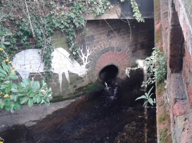
About a hundred metres on, we reach the Quaggy – another three way boundary in 1893 with Eltham replacing Kidbrooke. There is another boundary marker by the bridge over the Quaggy, its a defaced one of a similar style to that at the beginning of this section – rumour has it that the places were hacked out so as not to offer any help to German troops in the event of an invasion. There is though a better boundary marker almost below it though; by the outflow of the culverted Mid Kid Brook which as it joins the Quaggy is another Lewisham Natureman stag. This is the final one in the quartet of stags we have spotted on or close to the Lee boundary, so it seems an appropriate place to finish the circuit.

Notes
- Neil Rhind (forthcoming) Blackheath and Its Environs Volume 3
The Postcards are via eBay from 2016, apart from the one of Christ Church which is from a couple of years before.
Census and related data is via Find My Past (subscription required)
This, and the rest of the series of posts on the Lee boundary, would probably not have happened without Mike Horne, he was the go-to person on London’s boundary markers; he had catalogued almost all of them in a series of documents. He was always helpful, enthusiastic and patient. He died of a heart attack in March but would have loved my ‘find’ of a London County Council marker in some undergrowth on Blackheath during 2020’s lockdown, and would have patiently explained the details of several others he knew to me. A sad loss, there is a lovely series of tributes to him via this link.


