Tag Archives: Sydenham

Pissarro’s Stream – A Lost Sydenham Watercourse

There is evidence of at least a dozen streams having flowed from the high ground of Sydenham Hill to the River Pool.  Many no longer flow – some victims of changing water tables and spring lines, others lost to Victorian drainage.   Running Past has already covered a couple of these – Adams’ Rill and Wells Park Stream, and over the next few months will cover most of the others.  This post covers a stream to the south of the other two which, as far as I can see, is currently nameless, but will be referred to as Pissarro’s Stream, for reasons that will become obvious as we proceed downhill.

The stream seems to have emerged around the location of what was originally called Horner Grange (above), just east of Charleville Circus. The upward pointing contour lines (streams erode, so notches appear on contours) peter out around the Grange.  Horner Grange was built as home to William Knight who made a fortune diamond mining in South Africa in 1884, and he lived there until his death in 1900 – he was buried at West Norwood Cemetery. After Knight’s death, the house became a hotel and then the freehold was bought by Sydenham High School in 1934.  The Grange remains but its grounds have been heavily built upon by the School and there are no publically visible hints of fluvial activity.

A contour  line notch below the school suggests a route across a small cul-de-sac, The Martins, off Laurie Park Gardens. There is a small depression in the road which is clearly visible.

Just below it, on the stream’s course was the large Westwood House, once home to Henry Littleton – who had made his fortune from Novello’s, the music publisher.  Littleton invited many of the leading lights of classical music of the era to stay and the music room saw performances by both Dvorak and Liszt.

The house had started more modestly around 1720, but there were several ‘water features’ including a small lake, perhaps fed by the Stream – this is visible on the Ordnance Survey map below (on a Creative Commons via the National Library of Scotland) from the 1860s.  The scale had reduced by the time the map was redrawn in 1897 . Westwood House later became the Passmore Edwards Teacher’s Orphanage and was demolished in 1952 to make way for the Lewisham’s Sheenwood council estate.

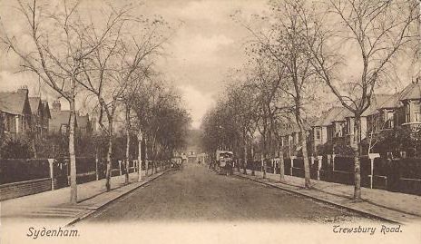
Just below Sheenwood, the stream comes to one of the more famous artistic views in South London – Pissarro’s painting of The Avenue, Sydenham dating from 1871 (Via Wikipedia on a Creative Commons).  Pissarro was to later note to his son ‘I recall perfectly those multicoloured houses, and the desire that I had at the time to interrupt my journey and make some interesting studies.’ (1)

Pissarro was one of a number of artists who fled France at the beginning of the Franco Prussian War in 1870.  While unlike some of his fellow artists, Pissarro wasn’t at risk of conscription – he carried a Danish passport but left to escape the Prussians in his village of Louveciennes.  He settled in Norwood, close to his mother who had already fled France with other members of her family.

The stream would have flowed around where  Pissarro set up his easel on what was then Sydenham Avenue, now Lawrie Park Avenue, although the stream was almost certainly not visible on the ground at that point in time – it wasn’t marked on the map surveyed in 1863 (see above).

It is often said how little the view has changed, certainly the backdrop of St Bartholomew is still there and the road remains. While the view would have been similar until the 1960s, Dunedin House to the left is still there, but less visible.   The street is now dominated by 1960s or 1970s housing, the mode of transport is much changed and the trees are much bigger even at a similar time of year to the original (see below).

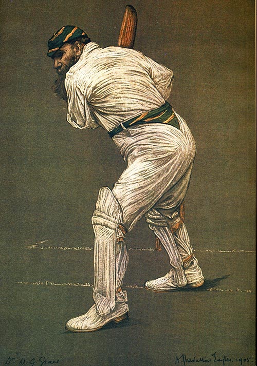
Beyond Pissarro’s view, the stream would have crossed Hall Drive, where there is a perceptible dip, and then dropping a little further to Lawrie Park Road – the hollow is more  distinct there.  The Stream would have flowed close to the site of the home of one of Sydenham’s more famous former residents, the cricketer WG Grace – whose time in South London was celebrated in Running Past around the centenary of his death.

The short-lived Croydon Canal (opened in 1809) and then its successor the London and Croydon Railway will have blocked the passage of the stream.  Whether the stream  was flowing when the former was built at this point is debatable, and if it was, it is unclear as to  whether it was culverted underneath or allowed to drain into the Canal.

Over the railway, Venner Road is crossed by the stream at Tredown Road, the course is clearer from contours than it is on the ground.  Beyond another faint dip on Newlands Park, the ground flattens out into lower Sydenham.  The route, becomes much less clear to follow.  Even the Environment Agency Flood Risk maps which show 100 year surface flow peaks and often indirectly indicate former streams don’t help much here.

However, they show clearly the two possible routes for the stream, either side of a small hill that is obvious from Kent House Road to Kangley Bridge Road.  There are possible routes either side of the knoll.

595134BA-ED3D-4F34-B9CC-41399EA736DB

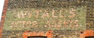
The northern option around the less than grassy knoll would necessitate crossing Trewsbury Road (picture above – source eBay November 2016) and then passing close to the Kilmore Grove former ghost sign and the home of the author Graham Swift’s father in Fairlawn Park before a confluence with Wells Park Stream around Home Park.

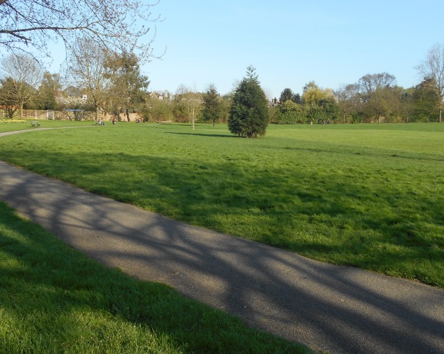
The southerly option would have seen a flow through Alexandra Recreation Ground where there is a very slight dip, through another on the elegant Cator Road Beyond Woodbastwick Road the boundary would have bifurcated from the Indeed, the Environment Agency surface water flood maps, which show 100 year  extremes, and often highlight to course of former or hidden streams suggest potential flows either side of the hillock.

image

There are a couple of southerly options  – Bing maps has a bit of blue indicating a stream through some allotments off Kent House Road – it wasn’t visible either on aerial photographs or marked on Ordnance Survey maps  and despite the warm sun of the late afternoon when I was doing the ‘fieldwork’ no one was visibly tending their vegetables.  Notched contours on Ordnance Survey maps would support this route though, as do some ‘puddle’s on Environment agency map above.  However, as the flows onwards from here would have seen the pre-development contours obliterated by the Beckenham and Penge Brick Works, so any certainty is hard to come by.

The second option would take the stream close to the junction with Kent House Lane and Kent House Road, alongside some other allotments, there is flowing water for around 50 metres to a confluence with the Pool, including a small bridge that carries National Cycle Route 21.  As there is water flowing and any post on a stream is better with an actual fluvial flow this would be my preferred option for the final metres of Pissarro’s Stream.

Notes

  1. Quoted in notes adjacent to painting in Tate Britain’s ‘Impressionists in London, French Artists in Exile (1870-1904)’

Wells Park Stream – An Almost Lost Sydenham Stream

Running Past has already covered one of the many streams that flow into the River Pool whose sources are in the high ground of Sydenham Hill – Adams’ Rill – which rises a little way down the slope around Peak Hill.

The second of the streams has two main sources, both almost as high as it is possible to get in in the catchment – close to the watershed with the Effra, known locally as Ambrook River, of Sydenham Hill – the road, rather than the area.  Sadly, the watercourse seems to be nameless; however, if, dear reader, you are aware of an appellation please do get in touch.  But for the purpose of this post, I will give it a name. The first part is relatively easy – the watercourse is only visible in Wells Park so it seems appropriate to use that.  The second element is trickier; I am slightly tempted to continue with ‘Rill’, despite its geographical inaccuracy.  There are strong regional variations in stream naming conventions – the most common in the south east being Brook and Stream. Locally, in the neighbouring Quaggy catchment ‘Ditch’ was the most common name for a small watercourse – appearing in Hither Green, Milk Street and Grove Park to name but three; it even has a counterpart in the Ravensbourne catchment – Chudleigh Ditch, also known as Honor Oak Stream.  The latter though is a suffix is used by a couple of nearby watercourses in the Pool catchment in Penge – Border and Penge Streams – so it probably has to be Wells Park Stream.

The northerly source is around the housing association development of Mount Acre Close – the westerly pond on the map below; there is some impenetrable chain link fencing at the side (above, left), protecting the careless intrepid urban explorer from a deep gully.  There is no obvious sign of water though. The rest of the estate is guarded by robust looking close boarded fencing.

The reason becomes obvious when looking at late 19th century Ordnance Survey maps, the steep slope behind the fencing is a deep railway cutting – part of the line into Crystal Palace High Level station from Nunhead – where it met up with the Greenwich Park Branch covered a while ago in Running Past.  The former railway has annihilated the contours indicating the stream’s route at the foot of the cutting, now the social housing of Vigilant Close, managed by Lewisham Homes (bottom photo above).  The likely route seems to roughly follow a path through gardens to Longton Avenue, although the ‘private land, no public access’ signs as I emerged suggest I may have gone a little off track… A fierce look from a window should perhaps have been a warning.

There is a tell-tale dip in Longton Ave, caused, no doubt, by the stream’s erosion – all too obvious to the fluvial flâneur.  Beyond the tarmac, and into Sydenham Wells Park, a vista of the rest of the route emerges.  On a clear day it is possible to pick out the gas holders adjacent to the confluence with the Pool, but it was a little harder on a slightly hazy winter’s afternoon.  The distinct valley through the Park though is obvious – part of a much larger one bounded by Wells Park Road and Westwood (formerly just West) Hill.

In the mid-17th century mineral waters were discovered on Sydenham Common in the area now partially occupied by Wells Park – those taking the ‘waters’ were rumoured to include George III and they were described as ‘a purging spring, which has performed great cures in scrofulous, scorbutic, paralytic, and other stubborn diseases.’  Another described them as ‘of a mild cathartic quality, nearly resembling those of Epsom.’

The southern source too would have been close to the watershed; it too has been truncated by the arrival of the steam train to serve the visitors to the Crystal Palace.  The Green Chain Walk tacks up the side of the cutting behind the tower of Cambria House – there are one or two dips in the well managed woodland hillside (work was being carried out by Friends of Hillcrest Wood and the London Wildlife Trust when visited) which hints at possible former courses.

Back on High Level Drive (a continuation of Vigilant Close) there is a clear dip which is roughly in the right place for the formerly flowing stream, although the railway disruption makes this less than certain.  The landscape has effectively become terraced to make best use of the land with roads hugging the contours of the hill; passage to the next stratum of housing down, Longton Avenue, involves a circuitous detour.  A little further to the east along Longton Avenue was one of the homes of C S Forester, covered a while ago in Running Past.

Like the northern counterpart, the southern branch of the stream has eroded a small depression which has been smoothed rather than filled by the Edwardian road engineers.  Into Wells Park and the route becomes more obvious than that of its sibling – mainly due to the presence of water.  When the Park was opened it was noted that

“Advantage has been taken of the natural undulations and the existing watercourses … and was ornamented by a succession of small lakes and rivulets”.

The stream actually flows as a stream for twenty metres or so before disappearing into a culvert which seemed to have a rudimentary trap to prevent underground blockages downstream.  There seems to have been another pond, the Children’s Yacht Pond, lower down in the Park which has now been filled in (Source – eBay July 2016).

The exact location of the former confluence of the two branches of the stream is probably just beyond Taylors Lane.  There is a clear dip in the road close which marks the boundary between Victorian terrace and 1970s council housing as well as the location of the stream (when it flowed).

The path downhill is clear the stream’s route is a relatively deep valley between the higher land of Wells Park Road and Westwood Hill, it appropriately follows Peter’s Path.  There was a pair of small ornamental lakes here when the Ordnance Survey cartographers called in 1863 (see above).  They were filled in when the Victorian terraces to the south of Wells Park Road were built before the century was out.

Beyond the flats and concrete garages that replaced their late Victorian counterparts in the 1970s the route is barred by a locked a gate to Longton Nursery Allotments, with no sign of life beyond it on a cool January Friday afternoon.  It has been a nursery or allotments since the late 19th century, perhaps too damp and at risk from flooding to allow development at that stage. It too had a small pond along the line of the stream’s flow in 1893, although this too had gone before the outbreak of the Great War.

The next physical sign of the stream is another dip in the road, a relatively pronounced one in Jews Walk.  A few metres away was the home of Eleanor Marx at 7 Jews Walk (Source eBay Nov 2017); she was the youngest daughter of Karl Marx and she spent her last few years there with her long partner Edward Aveling – they had not married for political reasons.  The historical orthodoxy, based on the inquest findings, is that she committed suicide after discovering that Aveling had secretly married an actress.  A recent biography by the very persuasive Rachel Holmes, suggests that Aveling murdered her rather than it having been a case of suicide.  There is a little more on her time in Sydenham and the possible reasons for choosing the home in the Sydenham and Forest Hill History blog.

The stream next ‘appears’ crossing Kirkdale close to Collingtree Road, it became visible during  road works in the early 21st century.  As Collingtree Road has an upward gradient towards the summit of Peak Hill the route will have skirted around its base into what is now a small park – Kirkdale Green, it may well have been joined by water from another source here as at least one spring has been found underneath a Collingtree Road house.  The dip in the appropriately named Spring Hill shows the line towards the railway.  There is a large mound of earth adjacent to the likely former route with some brickwork similar to ‘springs’ elsewhere – I have not found anything on-line as to whether the small summit has any significance.

The short-lived Croydon Canal (opened in 1809) and then its successor the London and Croydon Railway will have blocked the passage it seems that that unlike some of the streams from Sydenham Hill, it appears that this one was culverted underneath – certainly it was still evident on the other side – after the railway largely took over the route of the Croydon Canal.

Over the railway, the valley is obvious when crossing Silverdale before cutting through the Thorpes estate, where it was above ground  pre-development as the 1863 map below shows.

The ‘Thorpes’ Estate (a suffix to Kings, Queens, Bishops, Prince, Dukes and Earls) is a largely Edwardian development built by the firm of Edmondson & Sons between 1901 and 1914 over the garden of the Old House, the former home of the Mayow family – who gave their name to the neighbouring road and park.

It is a conservation area where

“Features and details used were inspired by the Queen Anne, neo-Georgian and vernacular revivals using red brick contrasted by white roughcast, multi-paned sash windows, grey slate roofs and decorative pargeting.

The area’s character is enhanced by its compact layout of tightly packed houses, small front gardens and tree-lined streets.”

There are perceptible dips in the north-south roads on the estate as the postcard below (source eBay July 2016) shows.After leaving the Thorpes the lie of the land dictates that it would follow Sydenham Road behind the Dolphin pub.  While the Ordnance Survey maps suggest some sort of bucolic idyll of a stream tumbling down the hill towards Bell Green.  However, it wasn’t always like that – in 1856 the Lewisham Medical Officer for Health described it as

An open ditch at the back of the Dolphin Inn, Lower Sydenham (after which it was covered) is most dangerous and offensive.

While seemingly hidden for most of its course through Lower Sydenham from at least the 1850s, it may well have fed a small ‘water feature’ in Home Park visible on the first Ordnance Survey Maps;k, It possibly also originally provided water for the long-lost Sydenham Brewery, but hopefully by 1856 a different source have been found!  

This is an area which has flooded in the past – possibly as a result of the stream bursting out from its culverting – the photo below looking toward Home Park is from 1907.

The confluence with the Pool appears to have been between the unlikely pairing of gas works and watercress beds.  It would have been under what is now Sainsbury’s car park.

There is an outflow into the River Pool at  roughly the right location – little in the way of water flow is ever seen from it though.

Photo Credits

The maps are all from the National Library of Scotland on a Creative Commons, the photo of the floods is via Steve Grindlay’s lovely photo stream on Flickr, which is well worth a visit, and is also on a Creative Commons.

Adams’ Rill – A Lost Sydenham Stream

The high ground of Sydenham Hill forms the watershed between the Pool and the Effra, known locally as Ambrook River, there are numerous springs on both sides of the fluvial divide; Running Past will be following those heading broadly east south east towards the Pool.  The first of these posts has a source around 500 metres from the edge of the Pool’s catchment on the small protuberance of the appropriately named Peak Hill.

Some maps mark a small pond in what would be the playground of St Bartholomew’s Primary School, although it has never been obvious on current or past Ordnance Survey maps, present day satellite views of the area or from the road.  However, that area would seem to have been the roughly the source of the stream.

The first obvious hint of stream is a dip in road as Sydenham Park Road (above) bends sharply to the north east close to a turning to The Peak and the likely original source.  The original flow would have taken the nascent stream through what are now gardens before emerging into a clear dip in Silverdale around Paddock Close.

The gap between the two roads is little more than 120 metres, but what lies betwixt the two will have changed the stream’s flow – firstly the short-lived Croydon Canal (opened in 1809) and then its successor the London and Croydon Railway will have blocked the passage.  Unlike some of the other streams coming off Sydenham Hill to the north of this, it seems likely that the flow continued under the railway as a series of ‘water features’ continued along the stream’s route when the Ordnance Survey surveyors visited in 1863, see above (1).

After a line that takes in some garages the hint of a shallow valley appears in the green flagged Mayow Park, particularly at the southern end facing onto Mayow Road.  The Park itself dates from 1875 and was created by public subscriptions from the great and the good in the area – particularly Mayow Wynell Adams.  It has a rather grand drinking fountain remembering the Reverend W Taylor Jones – another of the benefactors.

Sydenham and Forest Hill Recreation Ground was part of a Victorian movement of trying to allow the ‘less fortunate’ to take the air.  As was noted above, the 1863, post canal and railway, Ordnance Survey map suggests the stream was still flowing at the time the surveyors visited so the culverting was probably when the Park was created.

The stream crosses Mayow Road (see above – (2)) in a very clear dip where water often collects after rain and then heads off down Adamsrill Road in an obvious  valley, initially, at least, with paths to back gardens on the right being upwards as is the incline on Niederwald Road.  As the ‘rill’ in the street name is one of a myriad of names for a stream and the Adams prefix will have related to the local benefactor Mayow Wynell Adams, it is not unreasonable to call the stream Adams’ Rill.

The geographical pedant may dispute the appropriateness of calling it a ‘rill’ though as in relation to ‘hillslope geomorphology, a rill is a shallow channel (no more than a few tens of centimetres deep) cut into soil by the erosive action of flowing water.’  The size of the small valley as the stream heads down Adamsrill Road is considerably deeper than this.

As Adams’ Rill continues down the eponymous street, the locally listed gas holders Bell Green dominate the view.  The gas works have been there since the 1850s, it ceased to be operational  as a gas works in 1967 although it was not until 1995 that the first retail unit, Savacentre (now Sainsburys) opened on the site.  Other than the gas holders the only remaining  part of  Bell Green’s gas producing past is the works social club, now called the Livesey Memorial Hall (below).

 The exact route the stream took to the River Pool is not clear – the gas works obliterated the contour lines.  However, on modern 1:25,000 maps there is an upward pointing contour line to the north east of the gas works (now a retail park) site, it contains a small pond – often complete with fishing heron.  It is just possible that the the pond is the last remnant of Adams’ Rill and that the stream is still just flowing.  The confluence would have been roughly at the location below, just beyond the point where the Pool ceases to be encased in concrete due to the pollution on the former gas works site.

Notes

  1. From National Library of Scotland on a Creative Commons
  2. Source – eBay – September 2017

A Faded Sydenham Ghost Sign of a Fine Sign Writer

Knighton Park Road in Sydenham is a street of small late Victorian three bedroom houses, typical of its era.  Apart from a few cars that use it as a cut through to try to avoid the traffic lights at the junction of Sydenham Road and Kent House Road, it’s very quiet once you get away from the internal combustion noise of the main road.

It isn’t an obvious location for looking for advertising ‘ghost signs’, like their modern billboard counterparts, they tended to be on main roads, in prominent locations, but this wasn’t an ordinary ghost sign – on the corner with Hillmore Grove there was a fading ochre painted advertising sign relating to ‘H Price.’

Henry Price lived and worked from 39 Knighton Park Road from before just World War Two to around his death in 1973; he painted signs and advertising boards as well as cars, vans and trucks.  His handiwork was on the corner of the house he used to live in.

The sign was striking, but much more impressive are the signs that he painted on the sides of vans, often those for a variety of stationery firms.  The stunning one below on a 20 cwt Morrison-Electricar has been shared by his grandson through Geograph  on a creative commons, but there are several others which have been scanned as part of a set on Flickr.

Sadly the sign is no more – I had waited for the perfect photograph opportunity on the north facing wall, hoping for the adjacent tree to be covered with spring blossom and combined with a lack of vans, trucks or cars before writing this post.  That perfect opportunity sadly never arose and, alas dear reader, the sign is gone – the house has been extended upwards and outwards and the outside render along with its ochre sign has been replaced.

This is no criticism of the owner or developer, signs like this are generally not protected, although their value is beginning to be recognised in some boroughs and local listing has given to a few signs in Hackney.

imageThere are better examples in Lewisham that tell more of the history of trades and shopping such as those to the family of outfitters John Campion in Catford and the painters and grainers C Holdaway & Son at the bottom of Belmont Hill that perhaps are more worthy of protection.


As the locations are being recorded and photographed on websites such as Ghostsigns, vast numbers probably don’t need to be protected.  In any case those that have survived generally only remain by chance – their location has protected them as in the case of the Campion one, or they have been hidden behind more modern advertising hoardings such as the Holdaway sign.  In any case, the signs were not designed to last that long and left to the elements will rapidly fade – the Wittals sign on the corner of Bankwell Road and Lee High Road was clear when it first emerged from behind a hoarding around 2005 but is now barely visible.  In any case, it is often the story ‘behind’ the sign that is more interesting than the sign itself – helping tell stories of lost trades, 19th century migration into the city and shopping patterns that have changed.

20140130-211250.jpg


Literary Lewisham – Graham Swift’s Last Orders

Running Past occasionally covers some of the writers that have formed part of the Lewisham’s literary heritage.  This has included some with clear links such as CS ForesterDavid Lodge and Robert Browning, plus a few where the links are a little more tenuous – including Thomas Dermody – a Lewisham resident only in is his dying days and burial at St Mary’s Church.

Graham Swift was born in Lewisham, and, if my memory has served me correctly, in a nursing home on Woolstone Road; this was based on an information board that used to be at Kirkdale Bookshop.  Certainly, Swift was born on the borders of Catford and Sydenham.

There are South London settings to many of his novels – his debut novel, the wonderful ‘The Sweet Shop Owner’ featured both Upper Sydenham (perhaps then home to his maternal grandparents) and Wandsworth; ‘Shuttlecock’ was set around Clapham Common and Greenwich Park featured in the brilliant ‘Waterland.’

His father was Lionel Allen Stanley Swift who was born in 1922; in the 1939 Register he is listed as living at 176 Fairlawn Park  – wrongly transcribed as Fareham Park – the house is still there, although did suffer damage following a V-1 rocket attack at the junction of Fairlawn Park and Sydenham Road. Swift’s paternal grandfather was listed as a ‘clothiers warehouseman and his grandmother doing ‘unpaid domestic duties’. There was another household member, presumably an aunt or uncle whose details are redacted.  They weren’t sharing, so it was a step up from some on the street.

His mother was living at 29 Burghill Road in 1939, his maternal grandfather an engineer/tester for a typewriter manufacturer, Swift’s maternal grandmother like the paternal one doing ‘unpaid domestic duties’. It was a house that they seem to be shared though with the Weiners – a mother and son, the latter a grocer’s assistant. The house was built a little later than many of the original homes on the street, and like Fairlawn Park suffered damage from a V-1 rocket which hit the junction of Burghill Road and Sunnydene Street.

IMG_3113

Swift’s parents were married in Lewisham in the second quarter of 1943 and Graham Swift was born into rationing in 1949. It was

a lower-middle-class postwar family in a time of austerity and retrenchment, with no one in the family who was in any way artistic or a potential mentor to a budding writer

The family moved a few miles to the south to Croydon in his early years, right on the edge of the city.  He was a scholarship boy at Dulwich College before heading to the spires of Cambridge via another scholarship.

His best known novel is Last Orders, it won him the Booker Prize – it is a gentle, moving road trip of four Bermondsey friends, carrying out the last wishes of their fellow drinker and mate for a scattering of the ashes in the sea at Margate. The novel subtly and poignantly tells their sometimes intertwined histories which ‘skeletons’ gradually emerge from.

The lives were spent mainly within a few streets of each other; the location could have been anywhere in south London, indeed anyone can put their own mental images of the places and it would work – mine was of Jamaica Road just east of the tube station.  It is a beautifully told story, perfectly-paced but not the perfect novel.   Swift has remarked “I don’t research; it’s a great destroyer of the imagination.”

There perhaps lies the reason for the slight imperfection, while the lack of research wasn’t important in terms of the location, I suspect that he missed a little of the linguistic nuances of that part of south east London spending a few hours in Manzes pie and mash shop on Tower Bridge Road and an evening or two in the local pubs might have ‘solved’.

The film of the book was equally good, filmed around Bellenden Road in Peckham in the early stages of its gentrification; it featured Bob Hoskins, Helen Mirren, Michael Caine, Ray Winstone, David Hemmings and Tom Courtenay – poster above on Creative Commons via Wikipedia.


Notes

Details of V-1 damage from Lawrence Ward (2015) ‘The London County Council Bomb Damage Maps 1939-1945’

Census and 1939 Register data from Find My Past.

Strange Treatments for Whooping Cough in Hither Green and Sydenham

One of the stranger medical trials in Britain happened at the Park Hospital, later known as Hither Green Hospital in the late 1940s – using a decompression chamber to treat whooping cough.

image

The Park Hospital from a few decades earlier (via eBay, Jan 2016)

The background was a serious problem in post war Britain with a whooping cough (pertussis) epidemic in 1941 with 173, 330 cases and 2,383 deaths.  There were over 60,000 cases and at least 500 deaths every year throughout that decade.

The trial had its roots in the 1920s when a Strasbourg pilot took his child who was suffering from whooping cough for a flight and found that the coughing had almost ceased after 3 days.  Why the pilot attempted this was not explained, though.  Further work done in Switzerland and Germany prior to World War 2  found that the ‘treatment’ was most effective in the 5th and 6th weeks of the disease and that it cured 30% of cases within 3 days and alleviated symptoms within a further 30% of cases.  However, given the scale of the problem and the limited number of non-military aircraft replicating the trials on a bigger scale were not really feasible.

whoop1

So a decompression chamber was used, initially in Paris, where the results seemed to be similar to those in airplanes, and in Sweden, where they were inconclusive.  The Park Hospital at Hither Green managed to get hold of a former RAF decompression chamber (pictured above and below – source British Medical Journal 1949) and tried the same testing – the initial reports published in the British Medical Journal were that it seemed to work for some cases – around a third saw significant improvement or cure.

whoop-2

Despite the technique seeming to work in at least some cases, the rationale for remained unknown.  There are few references to the type of treatment after the early 1950s, other than one suggestion that it continued to be used by the RAF as late as the 1990s. So it can, perhaps, be assumed that the later results at the Park Hospital were similar to the inconclusive ones in Sweden, or as we will see later, possibly overtaken by other medical advances.

There were several memories of the treatment in Facebook comments on the post – including being told that they were in a rocket going to the moon and it leading to subsequent issues with claustrophobia for one former patient.

The altitude treatment wasn’t the only rather odd treatment, in modern terms at least, tried in Lewisham there was an alternative tried at the South Suburban Gas Works at Bell Green in the 1920s (below – see notes for photo credit) when the company turned their pump room into a clinic where children who were suffering could go and ‘take the smells’ (1).

whoop-3

It wasn’t a new idea – there were Scottish reports of children living at a gas works not getting whooping cough during an outbreak in Fife in 1891.  It certainly wasn’t the only place in Britain where gasworks related ‘cures’ this were tried, with reports of it happening on a more informal basis in Shoreham on Sea and High Brooms in Kent amongst others.  There were several memories in Facebook comments on the post of similar strategies being used in relation to taking children to places where new road surfaces were being laid and making them breathe in the fumes.

The logic at Sydenham seemed to be that one of the gases, ammonia, had a similar effect to smelling salts, and the smell of the tar caused a tickling sensation around the throat which, while it brought on violent fits of coughing, seemed to remove the ‘whoop.’ (2)

image

The Bell Green gasworks have all but disappeared – all that remains is the former social club, the Livesey Memorial Hall (covered a while ago in Running Past) and the now threatened gas-holders.

P1010598-0

The trials in Hither Green were not that long before the  post-war introduction of both vaccines for whooping cough and antibiotics to treat the condition, both lessened the need to try other methods, so even had the decompression chamber ‘worked’ it may not have lasted that long anyway.

The disease has never been eradicated though – the vaccines wear off over time and there has never been complete take-up, in 2015 the provisional figures for recorded whooping cough (pertussis) were 3063 cases with 4 deaths.

Finally, there is a short film made by British Pathé News about the tests, sadly it isn’t one of the films uploaded onto YouTube so it can’t be embedded here – but it gives a few glimpses of the the Park Hospital and it is worth watching for that.


Notes

  1. Gipsland Times 7 January 1926 via the Washed Out Goth blog
  2. ibid

Picture credits – both the Sydenham pictures are on a creative commons via Steve Grindlay’s lovely Flickr page which is well worth a ‘visit.’


W. G. Grace in South East London

WG Grace was born near Bristol and the vast majority of his career was spent playing for Gloucestershire and England. The blog touched on his final cricketing home a few months ago whilst exploring the route of the Little Quaggy in Mottingham and, with the centenary of his death approaching, it seem apposite to spend some time exploring the ‘swansong’ of his career in SE London.

Grace played his final Test in 1899 and severed his almost career long relationship with Gloucestershire the same year; the reason for the latter was that he had accepted an offer from the Crystal Palace Company to set up a new county team, the London County Club – Grace was secretary, manager and club captain of the new County club. He was given an annual salary of £600, probably very well paid for the time, and worth around £58,000 at 2015 prices, so quite moderate compared to the earnings of the current cricketing elite.

Grace was already 51 when the 1900 season started. The matches played by London County were given ‘first class’ status but were not part of the County Championship which had started ten years earlier – Grace had opened the batting with his brother Edward in the very first County Championship match against Yorkshire. The lack of involvement in the County Championship meant that Grace was able to attract various leading lights of the days to play for London County in what were effectively exhibition matches, whilst they retained their attachment to their counties. Notably amongst these was CB Fry, who retained his link to Sussex.

image

WG Grace in London County colours – source Wikimedia Commons

The County had an inauspicious start losing to Surrey at the Oval by an innings in mid April 1900. The first home match at Crystal Palace was a draw against the same opposition three weeks later, both were the cricketing equivalents of pre-season friendlies.. The club played another eleven first class matches that initial season – although almost half were against teams other that counties – such as the Oxbridge Universities and the M.C.C.

Grace was the club’s big attraction though and he still averaged 37.09 with the bat in 1902, scoring 1187 runs; but as Grace’s form deteriorated with age, so did attendances and the London County lost its First Class status in 1904 and while it survived for another few seasons it folded in 1908.

One of Grace’s biographers, Robert Low, noted that

In truth, London County was never the serious cricketing project its backers had envisaged but more of a jolly swansong for the Champion in his twilight years.

The cricket ground was located roughly where the decaying 1970s athletics stadium is now located. It was also used for FA Cup finals, the 1905 final being the only surviving panorama picture (below) of the stadium. The stadium was taken over by Cristal Palace football club in 1905 who remained there until the park was requisitioned by the military in WW1, and slightly later by a speedway team that was later to become New Cross Rangers (covered in the blog in 2014).

image

Whilst at Crystal Palace, Grace was also involved with lawn bowls persuading the Crystal Palace Company to turn some of the tennis courts into bowling greens and was instrumental in creating England’s first indoor bowling green under the glass within the Crystal Palace. He was also involved in some of the early internationals and governance of the sport.

Whilst playing for London County Grace lived in nearby Sydenham at 7 Lawrie Park Road, a house called St Andrews.  The house is no longer there is a new development there with a maroon plaque and the roads either side are named Cricketers Walk and Doctors Close.

image

He then moved to Mottingham in 1909, living at Fairmount on Mottingham Lane, now a residential home.  The plaque was unveiled in 1966 by Stuart Chiesman, Chairman of Kent County Cricket Club, who was a son of one the founders of the Chiesman’s department store in Lewisham – which had been founded in 1884 – and was taken over by House of Fraser in 1972.

image

Grace played for the local team, Eltham, who were based at Chapel Farm, the current location of Coldharbour Leisure Centre – where he played his final game on 8 August 1914 although he neither batted nor bowled. The last match he had batted in was against Grove Park, where he had scored an unbeaten 69 a couple of weeks earlier.

Grace died on October 23 1915, following a major heart attack, and was buried in the family grave at Beckenham Crematorium and Cemetery in Elmer’s End, close to the resting place of Thomas Crapper.

The World War 1 Bombing of Sydenham Road

The main aerial threat to London up to around 1917 had come from the Zeppelins, these largely stopped after the ‘silent raid’ of October 1917. While Zeppelin L45 left a trail of destruction in its wake in London, including the destruction of several houses, killing a dozen people in Glenview Road in Hither Green, most of the Zeppelins were lost including the L45 – this was covered in a post a few months ago.

The Germans started using Gotha aircraft for bombing raids on London in May 1917, initially during the day but then at night in an attempt to reduce plane and pilot losses.

The last WW1 raid on London was over the night of 19 to 20 May 1918 was perhaps not unexpected, while Londoners had been enjoying a sunny Whitsun Bank holiday weekend, there had been a raid on Friday 17 May 1918 – there had been two bombs dropped on and around Hither Green Lane one of which was near St Swithun’s Church, fortunately no people were injured or killed.

Thirty eight Gotha and three Giant aircraft headed for London on evening of 19th May 1918 and started to come inland over the North Kent coast and following the Thames inland around 10:30 pm. They met considerable resistance from the newly formed RAF with at least 6 were brought down by British planes and anti-aircraft fire and, and others were forced to turn back before they reached Britain. There are some suggestions that as few as 18 of the 41 planes actually got through.

However, those that got through were able to drop somewhere between 1200 and 1500 kg of bombs. The bombing happened over a wide area with the police reporting 72 bombs being dropped in London – most of these were to the east and south east of the City. These included attacks in Hither Green, Lewisham, Lee, Catford, Bexley, Bexleyheath, Sidcup and Sydenham. In total 48 were killed and 172 injured.

Of the recorded Lewisham ones – a 50 kg bomb fell in Sangley Road, killing one person and injuring another with 44 houses were damaged. Two 50 kg and two 100 kg bombs fell close to 187 Leahurst Road, close to Hither Green Station. This damaged the railway line, 19 shops and 63 homes, killing 2 soldiers and injuring 6 people. Unlike the WW2 bombs, there seems little evidence there now of the bombing.

IMG_0545.JPG
A 100kg bomb was dropped on the corner of Sydenham Road and Fairlawn Park it demolished a diary at 198 Sydenham Road, the bakers next door at 200, a marine store at 202 and badly damaged the confectioners at 204.

IMG_0546.JPG
Picture from Lewisham WW1 wiki

There were 18 deaths, including 5 soldiers – the largest loss of life anywhere in London that night. The soldiers were part of a temporary army mechanical transport depot, presumably based at Home Park, but were billeted in empty shops on the opposite, north side, of the junction of Fairlawn Park and Sydenham Road.

The main civilian losses were at the bakery and the diary, where five members of the Delahoy family who ran the dairy perished – the parents Isaac and Eliza, who were both 57, and their children Mary (14), Beatrice (17) and Laura (20). From the excellent Delahoy family history site, it seems that that Isaac hailed form Lincolnshire, and had married Eliza and by the time their oldest son Frederick was born in 1883 they were living in Dalston. By the following year they were in Wastdale Road (another dairy) in Forest Hill moving to 71 Beckenham Road in Penge by the time Laura was born in 1897. By the 1911 census Isaac, Eliza and the younger children had moved to Sydenham Road.

IMG_0548.JPG
A montage of 1917 photos of Laura, Mary & Beatrice

Whilst at Sydenham Road, in 1908 Isaac had been found guilty of selling something equivalent to semi-skimmed milk as full fat and fined £5 – he blamed his wife for selling from the wrong pail …..

IMG_0547.JPG
Isaac Delahoy outside the dairy in 1917

The Official Report from the Government to the press on the bombings released the following day made great play of many of the victims ignoring advice to stay indoors and under cover – it pointed to 10 of the injuries and several of the deaths in Sydenham, although this seems to have been mainly the troops billeted to the north of the bakery and dairy.

The site of the bombing in Sydenham formed part of the playground of the Our Lady and St Philip Neri RC Primary School – the site may well have been hit again by the last V-1 strike on Lewisham in August 1944.  In May 2018, the school is in the process of being rebuilt there. The church (just to the west of the site) was itself destroyed in World War Two; and the shops on the north side of the street were eventually replaced by housing.

IMG_0549.JPG
It was ordinary Britons that lost their lives that night in 1918, but it should not be forgotten that ordinary Germans in their towns and cities were also victims of air attacks. There was twice the volume of bombs dropped by the British on Germany, while Berlin remained out of range, British and French aviators bombed many German cities, particularly in the Ruhr and the Rhineland, the industrial heartland of western Germany. Saarbrücken suffered particularly heavy bombardments in 1918.

There was a memorial put up to the victims, and those of the Zeppelin attack on Glenview Road in Hither Green seven months earlier at Brockley and Ladywell Cemetery paid for by public subscription.  It was next to the low service personnel memorial in the ‘Lewisham side’ of the cemetery.  Over the years the details of those who died became eroded and indecipherable.  The Friends of Brockley & Ladywell Cemeteries successfully sought funding to restore this memorial, which was unveiled on Saturday 21st October 2017.


Finally, a big thank you to the Delahoy Family history site for letting me use the two family photos in this post.