Tag Archives: Lenham Road

Brightfield Road – the Street with Two Names, Part 2

In the first part of this post, we explored the 19th century history of Brightfield Road from its building as Robertson Street to its extension and renaming in the 1880s. We turn now to the 20th century and beyond, looking in particular at how the street fared in the World Wars.

We pick up the story with the 1901 census; the street had changed in the late Victorian period from homes for the building trades employed by John Pound, and other local builders, as well as for servants for the large houses in Lee, to a wider mixture of working class occupations.  Looking at the lower numbers at the eastern end of the street, little had changed by 1901 with a mixture of working class jobs such as road mender, carpenter, horse keeper and coachman (this excludes the shops which we will return to in a later post).

The average size of households had reduced to 5.3 (from 5.8 a decade before) mainly as a result of slightly fewer households taking in lodgers and/or houses being split between households. This was much smaller than the numbers in the not dissimilar homes in Ardmere Road in Hither Green which were built at around the same time.

There was little change by 1911, although the average household size dropped again to 4.5.  The nature of the jobs was little different though – manual trades and still lots relating to horse based transport.

The street fared badly in World War One, many of the sons, brothers and husbands of the households were either volunteers or conscripts to fight on the battlefields of France and Belgium – eight of them never returned home to Lee all were buried in cemeteries or remembered on memorials close to where they died.

  • William Upton of number 42 was a Driver in the Royal Engineers and died on 13 March 1918. He was a labourer in civvy street and was around 25 when he died; he was buried at Sailly-Labourse Cemetery in France.
  • Sidney George Munday lived five doors up from William Upton at 52, he was a Private with The Buffs (East Kent Regiment). He was 21 when he died on 14 April 1918 and is remembered at the Tyne Cot Memorial in Belgium.
  • William Henry Church had lived just over the road at 33, he was just 20 when he died serving as a Private in the Queen’s Own (Royal West Kent Regiment) on 18 September 1916.  He was buried at Etaples Military Cemetery in northern France.
  • Willie J Church was just 18 when he died on 6 June 1918, serving as a  Private in the London Regiment.  He is buried at Bienvillers Military Cemetery in France.  He lived at number 85, it isn’t clear whether he was related to William Henry Church.
  • Arthur John Cobb will have known Willie, as he lived  two doors away at 89 with his wife Gertie.  They served in the same Regiment too.  Arthur died on 18 February 1917 and was buried in France at  Merville Communal Cemetery Extension.
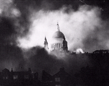
  • Alfred William Meggs lived seven doors down at 75, he was 20 and serving as a Corporal with the Queen’s Own (Royal West Kent Regiment) when he died on 3 October 1916.  He is remembered at the Thiepval Memorial, pictured above.
  • William George Bickle had lived five doors away at 65, he died two days after Christmas in 1915 aged just 16, the youngest on the street to perish. He shouldn’t have been there but, probably like Willie Church he will have lied about his age – soldiers needed to be 18 to sign up and 19 to be sent abroad as we saw with Herbert Burden from Catford who was shot for desertion aged just 17.

As World War Two broke out, the numbers living in the smaller houses at the eastern end of Brightfield Road were probably the lowest that there had ever been in the street’s existence – an average of just 2.9 people per home.  A large chunk of this related to the evacuation of children in September 1939, just before the ‘census’ for rationing purposes was taken, the 1939 Register.  However, even taking this into account household size had reduced with very few lodgers and a lot more houses just inhabited by couples and single people.  This will probably be at least in part as a result of limited non-contributory pensions being paid from 1909.

Since 1911 all the horse related trades had disappeared and the eastern end of the street was home to several involved in train, lorry and tram related transport.  There were several working at the Royal Arsenal making armaments.  Very few had the ‘Heavy Work’ suffix to their role which would have allowed them to have larger rations though.  The difference with Ardmere Road here is significant.   A slightly smaller proportion of women worked to 28 years before in 1911, but the trades were little more diverse – still mainly shop, laundry and work and dressmaking though.

There were a couple of nights heavy bombing in early December 1940, on the nights of the 8th and 9th of December.  Given the significance of these nights in the area we’ll return at some point but several houses had incendiary bombs hit them – 19, 20, 22, 43, 46, 52, 60, 113 and 123.  All seemed to have been put out and the houses remain.   There was a high explosive bomb that seems to have landed in the rear garden of 95 without causing too much damage.

Just after Christmas incendiary bombs rained down on Brightfield Road with 32, 34, 42, 43, 49, 63 and 83 all hit by them (some are pictured below) – the fires were put out by wardens and the inhabitants, but many of the roofs were damaged.

Early in 1941 there was a high explosive bomb that hit the roadway close to the bridge over the Quaggy, several houses were destroyed or had to be demolished due to the resulting major gas explosion (1). The damage is the darker colours is shown on the bottom left hand corner of the map below (2). No one died with only two requiring optional treatment but there was widespread damage in terms of broken windows and major structural damage to houses up to 100 metres away (3).

On the odd side, 103 – 107 were never replaced and the gap was used to form an entrance to Manor House Gardens.  Over the road, whilst the last house, 92 (at the left of the photograph) survived, 84 to 90 didn’t and they were replaced by private sector housing after the war.

Over the bridge, 75 to 79 were lost too at some stage in the Blitz.  They too weren’t replaced – the playground to what was then Hedgley Street School (now Holy Trinity School) was extended.

Several civilians on the street died;

  • Annie Taylor from 121 Brightfield  died in an attack on 110 Springbank Road as we saw in a post on that street;
  • Alfred Dibley of 56 died on 5 July 1944 at St John’s Hospital on Morden Hill presumably as a result of a V-1 attack;
  • Elizabeth Grant of 70 died at Albion Way Shelter early in the Blitz and
  • Eliza Jenner was injured at an attack on number 4 on 11 May 1941 and died at Lewisham Hospital the same day.  

There was a VE Day party there, a bit later than most on 2 June 1945.  The street scene is now markedly different – the attractive bank buildings (once a temperance coffee house) and the three storey shops at the end of the street were lost after the war either to Penfold’s or Sainsbury’s expansion.  We’ll return to the shops in a later post.

So who lives there now?  While it isn’t possible to use census data from 2011 just for the street there is a Output Area that relates to most of the street, along with Lampmead Road.  The employment categories are very different to the census data that we have looked at before.  The main employment types of the 196 residents in employment were shops (7%), finance, insurance and banking (10%), professional and scientific (13%), education (19%) and health (7%).  It will be interesting to see what changes there are when the 2021 Census results are collated.

Most of the homes seem to be owner occupied homes – although there are eight or nine owned by property companies letting the homes and three are let by social landlords.  The change is massive compared with when the homes were built as Robertson Street when virtually all will have been privately rented.

Certainly rising house prices will make affordability nigh on impossible for the sort of people that lived there before World War Two. One of the bigger houses was sold for £842,500 in 2020 – now single-family dwellings, when built they had been ‘conveniently arranged for two families. Let to very respectable tenants at 12/- a week’ in 1892 (4). 

One of the smaller houses sold for just under £500,000 just before the first lockdown.

We will return to Brightfield Road at some point in the future to look at the shops that used to be on the street.

Notes

  1. Phyllis Willmott (1988) Coming of Age in Wartime London, Peter Owen p51
  2. Laurence Ward (2015) The London County Council Bomb Damage Maps 1939-1945 p116
  3. Willmott op cit p51
  4. Kentish Mercury 25 July 1892

Credits

  • Permission has been given by the copyright owners of the Bomb Damage Maps, the London Metropolitan Archives to use the image here, it reamins their copyright
  • All the census and related data came via Find My Past (subscription required)
  • The photographs of the VE Day party is part of the collection of the Lewisham Archives, it is used with their permission and remains their copyright;
  • The photograph of the Theipval Memorial is on a creative commons via Wikipedia

Brightfield Road – the Street with Two Names (Part 1)

Streets having their names changed is nothing unusual – we’ve covered it a couple of times before with Dermody Road (formerly Hocum Pocum Lane), Waite Davies Road (formerly (Butterfield Street). Similarly, on the other side of Lee High Road the bottom of Dacre Park was previously known as Turner Road. Like the second two examples, there is fading evidence of a painted street sign bearing the earlier name. However, it isn’t as easy to decipher the former name, Robertson Street, due to multiple layers of faint paint, re-pointing and a burglar alarm. In a pair of blog posts we’ll tell the history of the street – from its building to the present day.

The builder of the original part was someone we’ve covered several times before, John Pound, mainly in relation to his house building but also shops on Burnt Ash Road, pubs and Lee Public Halls. The street was built by Pound around 1862 (1), with applications made to the Board of Works that March for drainage connections. The land was owned by Lord Northbrook, although it doesn’t seem to have been farmed as part of Lee Manor Farm – it isn’t in the farm map of 1846 – and the estate seems to have retained the freehold post development (2) as permission was sought from Lord Northbrook’s agent for some work.

The homes were unlike most of those in the rest of the area at the time. The arrival of the railway in Blackheath had seen substantial homes with space for servants built to the north of Lee High Road. The function of these smaller houses was similar to those in Lee New Town – providing homes for the servants who didn’t ‘live-in’ and working classes of mid-Victorian Lee. There was another function too, large-scale housing development in what was then suburbia needed somewhere for the building labourers and trades to live in an era without cheap public transport. Pound seems to have done the same around Waite Davies Road and Summerfield Street for his brickworks in South Lee. It was a pattern followed by Cameron Corbett with houses in Sandhurst Road a few decades later.

Pound also seems to have built the neighbouring Hedgely Street – he made an application for sewer connections in 1868 (3).  The street was adopted and paved in 1871 at a cost of 4/6d on the rates for occupiers – not the landlord (4).

So, who were the early occupants?  We’ll look at the first 20 houses in the 1871 census, the first census they appeared in; while the numbers appeared as consecutive in the census reports it isn’t clear whether this was the case on the ground.  The numbering is now odds and evens. The shops have been ignored for now, but may be returned to in a later post.

The majority (52%) of heads of household were working in the building trade, mainly skilled trades with the remainder split between various forms of domestic service and other trades.  Relatively few of the women worked, but those who did, tended to be listed in the census as charwoman or laundress.  While not in in the houses reviewed in detail, elsewhere in the street there were farm labourers housed – presumably still working at either Burnt Ash, Lee Manor or Horn Park which were all still working at that stage.

Almost half of the houses were either home to two households or took in a lodger, there were some very overcrowded homes as a result – 13 lived at no 17 for example. Almost all the households had children.

A decade later the average number in each house was 6.7 (it had been 5.5 in 1871), mainly due to an increase in lodgers and shared houses.  More women were working, although the trades were mainly around washing, ironing and cleaning.  Male employment had changed little too, the majority working in the building trades.

Unsurprisingly, there was some crime relating to the street, a fair amount of it alcohol related. John Mahoney had to be removed by heavies from the Tiger’s Head for being drunk and aggressive. He then went over the road to what is now referred to as the New Tiger’s Head, but press reports called the Little Tiger, where he was arrested after falling asleep drunk. He then violently assaulted the arresting officer for which he spent 6 weeks in prison (5).

Robert Stow was found guilty of assaulting a police officer after being arrested for being drunk and disorderly outside the nearby Duke of Edinburgh – his defence was that he didn’t know it was a policeman and that he’d had too much rum to drink cut no ice with the magistrates.  He was fined 20/- or 2 weeks in prison (6).

Theft wasn’t completely absent though – Thomas Upton (23) a labourer from 19 Robertson Street charged with stealing 25 hens from Blackheath Park and then selling them in Greenwich.  He was sent to prison for 14 days (7).

The western side of the terrace backed not onto the Quaggy, as it does now, but onto a path from that broadly followed what is now Aislibie Road.  After the floods in 1878 and probably also to allow better development of the land that was to form Lampmead Road, the Quaggy was deepened, straightened and took the route of the path. The differences are clear between the 1863 (top map below) and 1893 visits of the Ordnance Survey Cartographers.

The extension of the street to the northern side of the Quaggy seems to have happened around 1885 following the piecemeal sale of the Lee House estate. The builder may well have been George Mitchell; he made the application for connecting the new homes Brightfield Road to the existing sewers in what was still referred to as Robertson Street. John Pound asked for money for the connection (8). It is assumed that these would be the homes that are now numbered 109 to 127 Brightfield Road (some of which are pictured below), but could have been those to the south over the Quaggy.

Three years later a decision was made by the Metropolitan Board of Works in March 1888 to change street names in the area.  It seems that Lampmead Road was created, it had originally been a dog-leg of Lenham Road going towards Lee High Road.  The biggest change was in relation to Brightfield Road – from 1883 it had run from Old Road and then dog-legged around to the new homes built by George Mitchell.  The section from Old Road now became Aislibie Road and Brightfield Road, while shortened to the north took expanded over the river and Robertson Street was no more (9). In addition to the remains of the painted sign, a stone one remains and is now part of a garden wall.

The new Brightfield Road had changed a lot by 1891 compared with the last census for Robertson Street. John Pound’s building work had finished in the area and only 8% of the heads of household at the eastern end of the street were working in the building industry, just over a third were servants – mainly jobs relating to horses with the remainder a wide variety of manual jobs. As was the case a decade earlier a lot of the women worked – mainly as dressmakers and laundresses. Most households had children and most of the houses were either shared or homes to lodgers too – overcrowding remained, although it was less bad than in 1881 – the average was 5.8 rather than 6.7 a decade earlier.

There were a few sales of the houses which seemed to be all tenanted over the next few years. In 1892, 111 -125 (odds) were up for sale at auction. These are the larger houses backing on to Manor House Gardens, then let as a military crammer school before the House and Gardens were sold to the London County Council in 1898. The particulars of the sale of the houses in Brightfield Road noted the proximity to Lee and Blackheath stations. Each house was ‘conveniently arranged for two families. Let to very respectable tenants at 12/- a week.’ There were unexpired leases of 92 years (10).

Three years later some more of the later houses, 75-79 which were adjacent to the original houses were sold – they were advertised as being on long leases, having a weekly rent of 12/- and an annual ground rent of £5 (11).

The change in name didn’t stop crime relating to the street in 1897, Emma Agate was arrested for theft of a large number of garments from Lee Public Halls Steam Laundry (in early 2021 home to Travis Perkins off Holme Lacey Road) where she worked as an ironer, she was found with a number of pawn tickets. She denied the charges but was remanded in custody (12).

There were a couple of bigamy cases – William James was charged with bigamously marrying Mary Bator of number 61 in 1889 (13). Four years later, Walter Garland admitted to a bigamous marriage to Alexandra Taylor of 60 Brightfield Road (14).

We’ll leave Brightfield Road at the end of the 19th century, returning in the second part to cover the 20th century and beyond.

Notes

  1. Kentish Mercury 22 March1862
  2. Kentish Independent 01 June 1872
  3. Kentish Independent 10 October 1868
  4. Kentish Independent 16 December 1871
  5. Kentish Mercury 18 June 1870
  6. Kentish Mercury 30 October 1875
  7. Kentish Independent 10 April 1886
  8. Kentish Independent 02 May 1885
  9. Kentish Mercury 9 March 1888
  10. Kentish Mercury 25 July 1892
  11. Kentish Mercury 29 September 1895
  12. Woolwich Gazette 27 August 1897
  13. Kentish Mercury 13 June 1890
  14. Woolwich Gazette 27 April 1894

Credits

  • The maps are on a Non-Commercial Licence via the National Library of Scotland
  • All the census and related data came via Find My Past (subscription required)
  • The photo of the stone sign is courtesy of Frederic Heffer

World War Two Damage on Springbank Road

There have been several posts in Running Past on World War 2 bombings and post-war reconstruction, many of these have been around V-1 and V-2 attacks such as those on Lenham Road, Lewisham Hill, along with a pair of Hither Green ones – Nightingale Grove and  Fernbrook Road.  More recently Running Past has covered the attacks that happened on three nights on their 80th anniversaries – the First Night of the Blitz of the as well as the post Christmas raids on the nights of 27/28 and 29/30 December 1940.  We turn our attention now to the more widespread damage on Springbank Road caused through a variety of attacks. 

Key: black=total destruction, purple=damaged beyond repair, dark red=seriously damaged (doubt if repairable), light red=seriously damaged (repairable at cost), orange=general blast damage (non-structural), yellow=blast damage (minor), green=clearance area

The level and scale of damage becomes clear when looking at the London County Council Bomb Damage Maps pictured above (1) which shows that most of the houses in the street had some form of damage.  Rather than Springbank Road itself, Hither Green marshaling yards, behind the eastern side of the street, were one of the two main Luftwaffe targets in Hither Green during the Blitz, the other being the hospital (2). The damage was much greater to Springbank Road though than to the west of the railway. 

Large swathes of the street were mapped as red by the London County Council surveyors – ‘seriously damaged (doubt if repairable)’ or worse.  In reality, a lot more end up surviving the war than the map suggests.

The Air Raid Precautions (ARP) Service logs make for fascinating reading in terms of trying to work out what damage happened when in Hither Green and the extent of the damage.  However, as we’ve seen in relation the First Night of the Blitz as well as the post-Christmas raids, recording in the log was patchy at best with some high explosive and incendiary bombs only being recorded by the Fire Brigade and others, which were dealt with by local ARP Fire Wardens, were never recorded.

On the third night of the Blitz, on 9 September 1940, it is clear that 136 Springbank Road was hit.  What is less clear is whether this was a direct hit or the fallout from the bombing of the house behind at 51 Wellmeadow Road. This was the house was on the corner with Torridon Road and marked in black on the map above and was completely destroyed. This part of Wellmeadow Road was rebuilt after the War.  William Brown (83) and Alice Budd (56) died at 51 Wellmeadow Road that night. 

136 Springbank was less badly damaged, although it seems to have undergone some wartime or post-war rebuilding work as from the front from the variety of slightly different bricks were used.  One of the inhabitants was Mary Hutcheson – it was a large house that she shared with a couple – the Gallotts.   Mary was seriously injured in the bombing, although she lived for another 6 months before dying at St Alfege’s Hospital (later Greenwich) on 10 March 1941, aged 82. 

Elsewhere on Springbank Road, there was some serious damage further down the street with 213 to 225 completely destroyed. The date of this bombing isn’t clear as the attacks appear not to have been recorded in the ARP log (3).  Unlike 136 Springbank, no one was killed in the attack, although given the scale of the damage it would be surprising if there were no injuries.  213 to 225 (pictured above) were rebuilt as a mixture of Borough of Lewisham houses and flats after the war.  On the other side of the street, there was destruction and rebuilding too, but you have to look closely to see the differences compared with the original Corbett estate homes – the brickwork around the doors and windows is different and the homes are similar to replacement houses in Wellmeadow Rod, which we’ll cover below.

Elsewhere on the eastern side, homes got away with some more limited damage; there had to be re-building work at 211; while its next-door neighbour didn’t survive, the roof, chimneys and bay wall had to be re-built at 211.

There had were several nights during December 1940, notably that of 29/30, when the area on the other side of the railway had seen 1 kg incendiary bombs raining down.  Springbank Road escaped on those nights. However, three weeks earlier on the night of 8/9 December, there had been a similar attack over a slightly wider area – there were a trio of hits at just before 11:00 pm at the southerly end of Springbank Road – none of the repots had any indication of the extent of any damage or casualties.  It could have been the attack that destroyed 213 to 225, as the fire services will have been overstretched that night, although incendiary damage tended to be of a much smaller scale and often put out by wardens.

V-1 doodlebug attacks started to pepper the area from 16 June 1944 – in Hither Green and neighbouring areas, during the first week there had been attacks between George Lane and Davenport Road on 16 June; Lewisham Park the same day; Lewisham Hill and Leahurst Road on 17 June and the junction of Lenham and Lampmead Roads on 22 June. 

Research on the accuracy of V-1s has noted that they had ‘relatively low accuracy… compared to modern missile systems’ but that the aim of the attacks was ‘to achieve its terror and urban damage objectives’ rather than hit specific targets.  So, V1 flying bomb hits on Hither Green and surrounding areas weren’t specifically targeted here.  Indeed, as we have mentioned in other posts on V-1 attacks there is some evidence to suggest that false intelligence was spread back to Germany which indicated that the early V-1 flying bombs were overshooting the north west of London and latter ones were re-calibrated slightly leading to south London boroughs such as Lewisham, Woolwich and Croydon being disproportionately affected.

At around 7:15 in the morning of Friday 23 June 1944 Hither Green had a double hit either site of the railway – Fernbrook Road, which Running Past covered a while ago and Springbank Road; where the block of Corbett Estate housing of 104 to 116 Springbank Road was either destroyed or had to be demolished along with the similar houses behind in 27-37 Wellmeadow Road – the scale of debris blocked Springbank Road for a while.

It was perhaps surprising that only one person died, Annie Taylor (57) who was visiting 110 Springbank from her home at 121 Brightfield Road – Annie was a widow and had lived with her son and daughter in law.  There were several reports of the level of injuries in the ARP log – which were thought at one point to be as high as 25, although final tally seemed to be 14. 

We don’t know the identity of those injured but from the 1939 Register we can work out something about the people who were living in 104 to 116 Springbank Road and the houses behind in 27-37 Wellmeadow Road.  Before doing that, it is worth remembering that the houses had been built as suburbia for the middle classes of Victorian and Edwardian London.  The houses in Springbank Road were some of the later ones built on the Corbett Estate and didn’t appear in the 1901 census, but were in the 1911 edition. The difference between Springbank Road and nearby streets such as Ardmere Road in 1911 is dramatic.  The latter had been built as working class housing with the small houses generally shared between two households with income coming from manual work.  In Wellmeadow and Springbank they were office and sales jobs – with several commercial salesmen and clerks along with a cashier and an accountant.  There were no manual jobs apart from servants in 3 of the 11 houses.  Despite the large houses, large households were rare – it was a very different life to that in Ardmere Road.

By the time the 1939 Register was taken, both streets had changed a lot – the middle class had moved out and both Wellmeadow and Springbank Roads were homes to manual workers, the only exceptions being the adult Spurrell sisters at 112 Springbank – which included Edith who was a Ledger Clerk at a bookshop but also worked as an ARP First Aider.  They were more well-to-do than their counterparts in Ardmere Road and Woodlands Street, the households were smaller and there was less sharing.  Only 108 Springbank and 31 Wellmeadow were split between more than one household.  None of the men (or women) were able to claim the ‘Heavy Work’ supplement which entitled larger rations

The housing built after the war on both Springbank and Wellmeadow sides of the site seems to have been private sector; this is unlike many of the other V-1 attacks that Running Past has covered – Hither Green Station, Lenham/Lampmead Road, Lewisham Hill and Fernbrook Road where it was homes built for the local authority.  On Springbank Road 104 to 116 (pictured above) were re-built, initially as houses although most have been converted into flats. Based on Land Registry data, most remain in the private sector although one has been subsequently acquired a housing association. It was very different in Wellmeadow where the houses seem to have been built almost as 1950s versions of their predecessors – again all but one are privately owned, with one has been bought and converted into flats by a housing association.

Notes

  1. Laurence Ward (2015) The London County Council Bomb Damage Maps 1939-1945 – permission has been given by the copyright owners of the map, the London Metropolitan Archives to use the image here
  2. Godfrey Smith (1997) Hither Green, The Forgotten Hamlet p63
  3. It is possible that some mentions were missed when scanning through the very fragile records

Data Sources

  • The ARP records are via Lewisham Archives
  • 1939 Register data is via Find My Past – subscription required
  • Land Registry data is via Nimbus Maps – registration required.
  • The photograph of 136 Springbank Road is via Streeview

The Post Christmas Blitz on Lee Part 1 – 27 December 1940

Apologies if you’ve seen this before – the previous incarnation was partially deleted.
In the autumn of 2020, Running Past covered the attacks of the first night of the Blitz around Lee, Lewisham, Catford and Hither Green 80 years on. Over the next few months there were frequent attacks on the area – the worst night in the old Borough of Lewisham was probably the night of 8 to 9 December 1940. The Air Raid Precautions (ARP) Service Logs (an example of the log is shown below for 29 December 1940) noted for the night of 8-9 December

  • 126 high explosive bombs dropped;
  • 206 incendiary bombs – the number of both incendiary and high explosive bombs was almost certainly understated as the locations rather than numbers were often recorded;
  • 176 fires started – no doubt stretching the Fire Brigade to beyond breaking point;
  • 5 deaths; and
  • 175 injured – this was almost certainly a big understatement as at many locations injuries were ticked rather than having numbers.

However, around Lee some of the worst nights were at the end of December 1940 in two posts we’ll look at the nights 27/28 and 29/30 December where there were two nights of very heavy bombing.

There had been two quiet nights on Christmas Day and Boxing Day 1940, it was the lull before the storm with the night of 27/28 December being one of the heaviest nights of the blitz in Lewisham.

While there were attacks earlier in evening in Brockley, the first attacks on Lee was a series of incendiary bombs which hit at 19:51; one was at 33 Burnt Ash Road – a large house demolished after the war in the large scale demolitions of houses at the end of leases by the Crown Estate. There was no note of damage, but in the LCC Bomb Damage map the house ended the war with general, not structural, blast damage (1).

The other was at Reeds of Lee Green, a long standing drapers and furnishers that dominated the south east quadrant of Lee Green, straddling both Burnt Ash Road and Eltham Road – it was around 50 metres from 33 Burnt Ash Road. There was no damage marked there on the LCC Bomb Damage maps (2).

The final one of trio was at 57 Leyland Road (opposite the present day Alanthus Close) which was dealt with by officers from Lee police station.

Soon after at 20:05, another incendiary bomb was dropped close by in Burnt Ash Road between Southbrook and Micheldever Roads – there was a small fire which was quickly put out though.

There were several attacks on just after 9:00 pm on the then new homes on Upwood Road, (above) 34 and 22 were specifically mentioned but a couple of other incendiaries were reported as well. A hundred metres of so away 73 Leyland Road was hit by another incendiary. The was another dropped on Leyland Road between Dorville and Osberton Road – presumably somewhere around the current Carsten Close. With all of these the fires seem to have been put out by ARP fire wardens.

At around 9:12 pm, 41 Dorville Road and 36 Cambridge Drive were hit by incendiaries – as with the others in neighbouring streets they were put out by ARP wardens who had a busy night. The latter is a large surviving Victorian house, the former lost to the large scale redevelopment of Crown Estate land in the 1960s, but will have looked similar to the very different street scene from a few decades before.

At around 9:40 at least five bombs were dropped around Aislibie Road. One was in Manor House Gardens, which was home to three air road shelters. Fortunately the high explosive bomb hit a shrubbery between the shelters with only limited damage. Had there been a direct hit the loss of life could have been considerable as happened at Albion Way in Lewisham town centre on 11 September 1940 where 41 died.

A hundred metres or so away, 14-20 Lampmead Road (between Aislibie and Lenham Roads) were hit. Presumably the impact was in the road as none of the houses was destroyed although the ARP log noted that walls on all of them were cracked. Numbers 18 and 20 have survived but 14 and 16 were destroyed by a V1 flying bomb later in the war – the circle on the map.

More serious damage was around the corner in Aislibie Road with number 50 being hit directly and largely demolished and the houses either side rendered uninhabitable. The shading on the LCC bomb damage maps is incorrect here – the Ordnance Survey map of 1949 notes ‘ruins.’

Another bomb hit a few doors up, damaging 38 Aislibie Road- it wasn’t one of the houses destroyed during the war and was marked as blast damage – minor in nature on the LCC bomb damage maps. (3). If there was any serious damage it may have been made good by the end of the war.

In the same attack there was serious damage to the odd side of the road too, 17 to 23 had their chimney stacks knocked of; but 25 to 29 were left in ruins. The site had been cleared by the time the Ordnanace Survey cartographers mapped the area in 1949, but unlike similar small sites, such as Fernbrook Road, wasn’t used for prefabs. Again there were no reports on casualties here.

At around 9:45 there were at least four high explosive bombs dropped in the area around Winn Road area between Guibal Road and Senlac Raod.  The one at 87 Guibal Road failed to explode and the houshold had to be evacuated temporarily while it was made safe. The one at 105 Guibal damaged water, gas and electricity services, with the others not seeming to do much damage other than to gardens.

At 9:55 another high explosive bomb was reported as hitting Manor Lane – 50 was described as being ‘demolished’ and 48 and 52 rendered uninhabitable. Unless these were rebuilt in in exactly the same style as the W J Scudamore originals, it may be that the report was overstated. While there has clearly been some patching of walls, original features seem to remain.

Around 10:00 pm a small explosive bomb hit the old St Margaret’s Churchyard (pictured above) leaving a small crater and several damaged tombstones. A few minutes later there were a couple of incendiary bombs dropped on Lee High Road close to the current Mercator estate – an area that was to be devastated later in the war.

Overall, that night in the old Borough of Lewisham 

  • 97 high explosive were dropped;
  • 112 incendiary bombs fell;
  • 91 fires were started;
  • 3 died;
  • 12 were injured, this is almost certainly an understatement as some just ticked the box rather than entering a number; and
  • 12 were trapped by debris having to be rescued by emergency services.

It wasn’t just Lewisham that was attacked that night, The Times for the following day noted that ‘the raid equaled in intensity, but not duration, some of the heaviest attacks on the capital….from widespread areas came the same report of enemy aircraft flying over almost continuously dropping incendiaries followed by high explosive bombs.’ (4)

Whilst the following night seems to have seen another lull with defence guns silent (5), the Sunday evening of 29/30 saw the bombers return with in what was described in central London as the Second Great Fire of London but also saw numerous bombs dropped on Lee; we’ll return to this is the second part of the post.

Notes

  1. Laurence Ward (2015) The London County Council Bomb Damage Maps 1939-1945 p116
  2. ibid p116
  3. ibid p185
  4. The Times Saturday December 28 1940
  5. The Times Monday December 30 1940

Credits

  • Most of the information for this post comes from the Lewisham ARP Log – it is a fascinating document, which is part of the collection of Lewisham Archives. It isn’t a complete record – some incidents were reported to the Fire Brigade rather than the APR and some incendiaries were dealt with by residents or Fire Wardens without ever reaching the ARP service – this is particularly the case on busy nights such as this.
  • The map is from the London County Council Bomb Damage Maps, 1939-1945 – permission has been given by the London Metropolitan Archives, the copyright owners of the map, the to use the image here.
  • The photograph of Lee Green and the page of the ARP Log are both from the collection of Lewisham Archives, both are used with permission and remain their copyright.
  • The postcard of Dorville Road is via eBay in December 2019

The Post Christmas Blitz on Lee Part 2 – 29 December 1940

In the first part of this post we looked at the post-Christmas Luftwaffe attacks on 27 December 1940 on Lee which saw numerous bombs dropped and homes destroyed on Aislibie Road, the misspelled road, named after Benjamin Aislabie – slave owner, awful cricketer and tenant of Lee Place.

While there was a lull the following evening, it seems that the Luftwaffe were just gearing up for an even bigger raid on 29 December, the aim of which seems to have been to put the fire services under a level of pressure that they would be unable to cope with and see London burning.

The attacks were much more concentrated in a small number of streets between Lee High Road and and Manor House Gardens. Most were incendiaries, and along with a few high explosive bombs, were dropped in a few minutes around 8:15 pm.

As we found with the post on the first night of the Blitz, it is worth remembering that not every incident was reported to the Air Raid Precautions (ARP), some being just reported to the Fire Brigade but others never going through official channels. One of the pages of incidents for the night of 29/30 December 1940 is show below.

The first attacks of the night in Lee started at around 7:25 pm in Blessingham Road, when a high explosive bomb hit the back garden of number 38. Elsewhere on the street another high explosive bomb injured two people. The street was to be decimated by a series of V-1 flying bombs later in the war and was developed, initially as prefabs, and in the early 1960s, as the Mercator Estate.

Fifty minutes later, Lee was on fire, the ARP logs note several dozen incendiaries being dropped at the same time, so we’ll look at the attack on a street by street basis. Aislibie Road (pictured below) which had suffered badly two nights before, was again hit. It was different houses this evening with 5, 13, 26, 30 and 39 all being bombed with roofs and upper floors damaged by the incendiary bombs, none were destroyed though.

Parallel to Aislibie Road, and the location of a devastating V-1 flying bomb three and a half years later, is Lenham Road which saw 5, 7, 10 and 28 all hit by incendiaries. The fires were successfully dealt with by local ARP and Fire Wardens.

Incendiary bombs rained down on neighbouring Brightfield Road with 32, 34, 42, 43, 49, 63 and 83 all hit by them (some are pictured below) – the fires were put out by wardens and the inhabitants, but many of the roofs were damaged.

Elsewhere in the neighbourhood, the roof and upper floors of 24 Lampmead Road were damaged, as was 4 Hedgley Street. Taunton Road saw at least two attacks – number 60 was slightly damaged and 2 Thornhill Cottages saw its roof damamged. Thornhill Cottages was a terrace at the eastern end of Taunton Road between Burnt Ash Road and Hedgley Street seemingly on the present Sainsbury’s site.

At the opposite end of Manor House Gardens, 2, 44 and 61 Old Road plus Pentland House (pictured below) were all hit but Fire Wardens managed to deal with all four fires.

A little further along Lee High Road, number 345 was hit by another incendiary; ironically it had been a fire station up until 1906 when the one on Eltham Road opened, it is now a solicitors. The roof seems to have been damaged, and assuming that there was no damage on other occasions during the war, a central turret there was destroyed (there is a pre-damage photograph in the post on the fire station).

There was an explosive and incendiary combination dropped on Dacre Park at the same time and there were ‘several .. casualties in the road’ as a result.

Around fifteen minutes later at 8:30, a high explosive bomb hit Lee High Road between Old Road and Lochaber Road – there 5 casualties, including an ARP warden, with shrapnel damage to almshouses’ boundary wall that is still visible (along with a fading direction sign to an air raid shelter). The ARP warden was Henry Cottell of 41 Manor Lane Terrace who was to die later that evening in Lewisham Hospital – it was a house that seems to have been lost to the construction of Wolfram Close. Henry left behind two adult daughters and his wife Ann, who were there when the 1939 Register was collected.

Also at 8:30, Chiesman’s store repository at 87 Old Road was hit by a high explosive and incendiary combination – the ARP log noted that the repository was on fire. We’ll return to this incident later in the post.

One of the ARP Fire wardens for that part of Lee that night was Phyllis Noble (later Willmott), who lived at 49 Lampmead Road with her parents and grandparents. In the aftermath of the incendiaries being dropped, she and her brothers, who were also ARP Wardens, grabbed stirrup pumps, buckets and sandbags. ‘Incendiaries seemed to be everywhere, but so too were numerous fire watchers like ourselves.’ (1)

The first fire they dealt with was at the almshouses that stood at the corner Lampmead and Lee High Roads (pictured above) where a room had caught fire. They put out that and another in the neighbouring Methodist church, now the New Testament Church of God. Phyllis and her brothers spent the next few hours putting out fires in locations that didn’t even get a mention in the ARP log chasing ‘up and down stairs in the tall Victorian houses in the High Road.’ They reached Old Road and Chiesman’s Store depository by around midnight (2)

“As the red glow in the sky told us, there were still plenty of fires raging, including one in the furniture depository nearby. We went along to see if there was anything we could do there; giant tongues of red and gold flames were shooting skywards from the glowing building and clearly this was not work for us, in any case the firemen had already arrived.”

Had the Fire Brigade arrived earlier they may have been able to save 87 Old Road but it was largely destroyed.

Lee was probably only a stopping off place for the Luftwaffe as they headed towards the centre of the city. Later in the evening incendiaries rained down on central London in what was described as the Second Great Fire of London, the iconic picture of St Paul’s Cathedral amidst the smoke was from that night as 160 died and hundreds of buildings were destroyed in the capital.

Notes

  1. Phyllis Willmott (1988) Coming of Age in Wartime p50
  2. ibid

Credits

  • Most of the information for this post comes from the Lewisham ARP Log – it is a fascinating document, which is part of the collection of Lewisham Archives. It isn’t a complete record – some incidents were reported to the Fire Brigade rather than the APR and some incendiaries were dealt with by residents or Fire Wardens without ever reaching the ARP service – this is particularly the case on busy nights such as this.
  • The photograph of St Paul’s is via a Wikipedia Commons
  • The photograph of the Boone’s Almshouses and the page of the ARP Log are both from the collection of Lewisham Archives, both are used with permission and remain their copyright.

VE Day in Lee and Hither Green

Friday 8 May 2020 sees the 75th anniversary of Victory in Europe, VE, Day and would have been celebrated both locally and nationally if these were normal times – it was to be one of the themes of the 2020 Hither Green Festival – maybe this will be re-visited later in the year.  We’ll look at what happened that day in 1945 with a local perspective.

After Berlin was surrounded by Allied forces and Hitler committed suicide on 30 April 1945, the end of the war was quite rapid.  A week later, on 7 May 1945 Germany accepted an unconditional surrender of German Forces in most of the areas that they still occupied in the Netherlands and northwest Germany and the surrender came into effect the following day.  A further surrender document was signed with the Russians on 8 May.

Running Past has covered many of the areas of the Home Front in recent months (for the 70th anniversary of war breaking out); the winding down of the Home Front was rapid in early May – public air raid shelters were closed down, as was the air raid warning system and plans were made for the return of evacuee children and mothers by the end of May (1).

Over a million people took to the streets on 8 May in celebration throughout Great Britain to mark the end of the European part of the war.  Many massed in central London, particularly in Trafalgar Square and up the Mall to Buckingham Palace as featured in the video footage (the sound levels are a bit variable, so beware!)

Many celebrated locally though; South Park Crescent (above and below) had been built as part of the Verdant Lane estate in the early 1930s and was the scene of a large party.  No doubt the celebrations were tempered there though by memories of 5 children from there and neighbouring streets who were amongst 38 children and 5 teachers who died at Sandhurst Road School.  There had also been a V-1 flying bomb that hit the junction of South Park and Further Green Road less than a year before at 16:48 on 12 July 1944 which injured 15 (3) –  several houses were destroyed and lots damaged – perhaps including the roofs of those pictured below).

In and around Hither Green, there were several other street parties including ones in The Woodlands and neighbouring Blashford Street.

Lee too saw several street parties, mainly in the working class streets.  Taunton Road had seen a lot of damage in the Blitz with several lives lost.  There was a posed picture probably taken close to the park entrance, the road in the background is Wantage Road.

Just around the corner in Brightfield Road (below) there was another street party in the part of the street that was built by John Pound and had originally been called Robertson Street.  As can be seen from the photograph, the party wasn’t  held there until early June 1945. 

Brightfield Road had seen some damage from the V-1 flying bomb that hit the junction of Lenham and Lampmead Roads.  In addition, there was Blitz damage to houses close to the bridge over the Quaggy, with several destroyed and several seriously damaged; along with three houses on the southern side of the bend which were damaged beyond repair (3).  The houses destroyed in Brightfield Road were never rebuilt, a new entrance to Manor House Gardens was created in their stead and those damaged beyond repair suffered a similar fate – they were to become an entrance to, what became after the war, Northbrook School and is now Holy Trinity

The street scene is now markedly different – the attractive bank buildings at the end of the street were lost after the war either to Penfold’s or Sainsbury’s expansion – more on the building another day, as there is an interesting story behind it.

While there were dozens of parties, as Lewis Blake noted, ‘for all the public display, it may be assumed that a majority of people stayed quietly at home.’ (4)

In addition to the celebration of the end of hostilities, there will have been a relief that bombing and rocket attacks were over – roads like Springbank, Taunton and Aislibie Roads had been badly affected by the Blitz, with V-1s hitting lots of local streets – including Nightingale Grove, (pictured below) Fernbrook Road, between Springbank and Wellmeadow Roads along with Leahurst Road, and as we’ve mentioned the Lenham/Lampmead junction.

A couple of days after VE Day, Lewisham was visited by the King and Queen who stopped in a packed town centre to survey the damage caused by the V-1 flying bomb from 10 months before (it’s at about 4:10 into the film, which is sadly silent).

Other than the rebuilding which was to continue for the best part of 20 years, the other element of wartime privations that was to linger on for almost another decade was rationing, which didn’t officially end for meat until 1954.

If you have personal or family local VE Day memories, please do post them either in the Facebook thread you reached this post from or in the comments below, if you haven’t commented here before, it may take a few hours for your comment to be approved.  I will hopefully add some of the comments into the main post.

In early May 2020 we don’t have the potential for street parties, but oddly, despite the lock down, we are probably contacting and seeing more of our neighbours than any of the generations since the end of World War Two. Every Thursday evening with the #ClapforCareWorkers most of our small street come out to clap and bang pots and pans; if we are typical, people often stay out in the street to chat, keeping social distancing, of course.  Neighbours are checking in with each other by phone with shopping bought for those having to stay at home.  Perhaps, for now at least, this is the World War Two type spirit we should embrace and celebrate, the parties will have to wait.

Notes

  1. Lewis Blake (1995) How We Went To War – Deptford & Lewisham 1939 -1945 p62
  2. From ARP Logs held at Lewisham Archives
  3. Laurence Ward (2015) The London County Council Bomb Damage Maps 1939-1945 p119
  4. Blake, op cit p66

Credits and Thanks

  • Thank you to Andy Wakeman and Clive Andrews for allowing the use of their family photographs of the South Park Road party – the photographs remain their families’ copyright;
  • The photgrpahs of Brightfield Road and Taunton Road are part of the collection of the Lewisham Archives, they are used with their permission and remain their copyright;
  • The photograph of the destruction on Nightingale Grove is from the collection of the Imperial War Museum – it is used here on a Non-Commercial Licence

Old Road & Beyond – A Walk Through Some of Lee’s Past

The area bordering Manor House Gardens has a rich and interesting history which Running Past has written numerous posts about.  This post was written to ‘accompany’ a walk organised as part of the 2019 Manor House Gardens Festival, it can be used to independently to walk the route (it’s a circuit of around a mile, which can be found here) or as virtual tour of the area.  The ‘walk’ is divided into sections which relate to the planned stopping points – each of which is full of links to other posts in the blog which will have more detailed information.

Some Background

Before it was enveloped by the city Lee was a village, a village with three centres – Lee Green, the area around St Margaret’s Church and Old Road, as John Rocque’s map from 1746 shows.

Lee remained largely rural until mid-19th century until the coming of the railways – Blackheath & Lewisham stations opened in 1849, Lee in 1866 and Hither Green not until mid-1890s (it was just a junction before that).

The mid-1860s Ordnance Survey map above shows how little development there was beyond Lee Green and to the south of Old Road; farms remained until the 1920s and 1930s, such as Burnt Ash and Horn Park.

The Manor House

Old Road was once home to a series of large houses, starting from the eastern end these were Lee House, The Cedars, Lee Place, the Manor House, Pentland House and The Firs – geography played an important part, it is on a small hill which would have offered impressive views to the east and south but were high enough to protect from flooding from the Quaggy and the now diverted Mid Kid Brook, which used to flow down Lee High Road.

Lee Place

The first of the country houses was Lee Place; Its building was the result of the death of Lord of the Manor, Brian Annesley who had a moated farm probably where St Margaret’s Lee School is now situated.  His later years are believed to at least partially inspired Shakespeare to write King Lear – there was happier ending than in the play though.  The estate split up on his death.

Lee Place (above) probably built by/for George Thompson – had links to the slave trade but is better known as a soldier and MP during the Commonwealth brother of Maurice who lived at Lee Farm. It was the home to the Boone family (it was their family chapel) for several generations but was let out from the mid-18th century.  Its last tenant was Benjamin Aislabie.

The estate was sold in 1824 as still has an impact on the current landscape as it was broken up into relatively small lots which were developed at different times.  It allowed too the straightening of Lee High Road – the straightened bit was known as New Road for several decades

The Manor House

Lee Farm was previously on the site, which moved to what is now the junction of Baring and St Mildred’s Roads in 1727 and became Burnt Ash Farm. The former farm was bought initially by the slave trading brother of George Thomson, Maurice and then by William Coleman who sought to re-create the lands of the old Manor for his nephew,Thomas Lucas, both were ‘merchants’ with strong links to the slave trade.

The Grade II listed Manor House was built on the site of the farm in 1770 by Richard Jupp for Lucas.  It was bought by Sir Francis Baring in early 19th century, whose family wealth also had its origins in the slave trade – used it as their near London base – the merchant on the maroon plaque is depressingly vague. The Northbrooks let in out during much of the 19th century

They sold the house as a library and grounds to the London County Council in 1898 opening to the public in 1902.  The Northbrooks owned much of Lee and their gradual selling off of their ‘estate’ in the latter part of the 19th century which shaped the current urban landscape.

Pentland House

Pentland House was built in early 1790s and is probably the oldest residential building in Lewisham – it is a close run thing with St Mary’s Vicarage though!  It has been added to considerably and rendered in the early 19th century when extended.

It was home to the rich, but not that significant Smith family, who sold to some more Smiths, who sold to some more Smiths (albeit with a prefix) – it became a Goldsmiths’ College hall in 1913 which stayed until the early 2000s.  It is currently a largely backpackers hostel.

Flats & Houses Opposite

The houses and flats opposite are a bit less grand – Bankwell Road & adjoining bits of Old Road – completed in 1908, possibly by James Watt – it was the central of three plots of land bounded by Lee High Road and Old Road – as the 1890s Ordnance Survey maps below shows.

The eastern of the plots are Arts & Crafts style flats which are a bit out of kilter with rest of area.  The land they were built on had been part of Lee Place – the house itself was on this part.  The land was bought as an orchard and kitchen garden for Pentland House with the flats & Market Terrace on Lee High Road built in the mid-1930s.

Before moving on worth reflecting on the library, the park and indirectly the rest of the current urban landscape was paid for by the slave labour in the plantations of the Caribbean owned or traded by those that lived here and over the road.

On the way to Lochaber Hall at the first house on Manor Lane Terrace look at the wall – the remains of a sign pointing towards air raid shelters in Manor House Gardens (more on that later).

Lochaber Hall, the Firs, Holy Trinity

Lochaber Hall

If think Lochaber Hall looks like a church hall you’d be right, it was originally church hall for Holy Trinity in Glenton Road (pictured below).  The church was destroyed in the Blitz and is now Callaghan Close (almost opposite the Telephone Exchange) and named after the 1970s Prime Minister who lived in Blackheath.

The Hall was designed by Ernest Newton, a locally renowned architect and President of RIBA, he also designed St Swithuns, the original Church of Good Shepherd and Baring Hall at Grove Park. Slightly surprisingly it is Grade II listed. Immediately after World War Two it was used as a hall for the Church of the Good Shepherd as that church was largely destroyed in a fire & the congregation was using the adjacent hall as the church.

The Firs Estate

The Firs was another of the large country houses of Lee, it was a large red-brick house which was a built around 1700 as the ‘town’ residence for the Papillion’s, a prominent Huguenot banking family – it stayed in the family’s ownership for a century.  The last owner from the mid-1860s was John Wingfield Larkin, a member of a wealthy Kent family who had been a merchant in Egypt and British consul in Alexandria between 1838 and 1841.  The family sold up on his death as the city encroached in 1893.

It was developed as Murillo, Old, Rembrandt & Lochaber Roads by the end of 19th century.  It is not certain who the builder/developer was – although is a stained glass for Siderys on Murillo Road – who were prominent builders in the area.

The houses on the corner of Manor Lane Terrace and Abernethy were largely destroyed on the 1st night of the blitz.  27 Murillo Road was home to one of the more prominent Lewisham suffragettes – Caroline Townsend.

Lee Manor Farm

This was originally at the Manor House, moved to what is now the junction of St Mildred’s Road and was renamed Burnt Ash Farm in 1727; that farm was split in the early 19th century and new farm buildings constructed opposite The Firs (close to the current junction of Manor Lane Terrace and Manor Lane).  It didn’t stay the farm house that long and we’ll return to it at our next stop.

Junction of Manor Lane Terrace & Kellerton Road

Manor Park Estate

We are in the land of W J Scudamore here and along with John Pound are probably the two firms of builders that most influenced the area – buying land from the Northbrooks. W J Scudamore were based on Manor Lane (corner of Handen Road) then Lee High Road (part of Sainsbury’s site) and latterly on Holme Lacey Road in Lee and active in Lee, Hither Green and later elsewhere from the 1890s until the 1930s.

The Manor Park Estate (as the roads around here were originally referred to as) was built for a mixture of rent and sale – sale prices were £265 or£275 for the bigger ones – it was 1906…!

They definitely also built

  • Shops on Manor Lane (eastern side)
  • Newstead Road
  • Some of St Mildred’s Road
  • Holme Lacey & Dalinger Roads
  • Several small sections of Leahurst, Longhurst and Fernbrook Roads
  • Probably lots of others too

Wolfram Close

On the site of the last location of the Lee Manor Farm (pictured below) – the land farmed was to the south of here.  The farmhouse seems to have been sold with the land for the Manor Park Estate and became a home for the Scudamore family who remained there until 1961.

The site was redeveloped in the 1960s or early 1970s, it isn’t clear whether this was by Scudamores, as they went into liquidation in 1966. It is presumably named after the last occupant of the Manor House – Henry Wolffram from Stuttgart who ran a ‘crammer’ school for would-be army officers – the spelling of his name is incorrect though – the cul de sac as one ‘F’ the name two ‘Fs’.

The council estate behind Cordwell Road – is named after one of the last farmers of the farm.


Manor House Gardens

The park was created in the early 1770s as gardens for the Manor House until 1898 when the Northbrooks sold up to the London County Council (LCC), which as with Mountsfield Park on the Hither Green and Catford borders wanted to ensure that the newly developing suburbia had parks and libraries provided. The Gardens had been left in a poor state by last occupant (Henry Wolffram) and didn’t open to the public until 1902.

Source –  eBay Feb 2016

It contains a rather impressive Ice House which was used as an air raid shelter in World War Two; there were a couple of other ones too, the outline of one of them was visible in the parched grass in the hot weather of 2018.

The Gardens have been ‘listed’ since 1987 and underwent a major refurbishment in 2000.  The small lake has been part of grounds for most of its post agricultural life.  The River Quaggy flows through the Gardens, it used to be at a higher level but the bed was  excavated partially to reduce flooding – probably in the 1880s.

Behind the library, there are two little bits of Catford – foundation stones for the now demolished St Laurence Church and the original Town Hall.

Lenham Road/Lammead Road Corner

If we were standing here in the 1870s we would be in or next to the River Quaggy as there was a meander that originally came up to this point. It was straightened in 1880s both to allow development but possibly too as flood prevention measure – there were really bad floods in 1878.

Most of housing on Lenham, Lampmead (and Aislibie that will walk up) Roads dates from late 1880s when Lee House (more on that later) was demolished and the land sold for development. It was slightly different on the other side of the river – Robertson Street, now Brightfield Road probably dates from the late 1850s or early 1860s.

The houses at the corner are very different – early 1960s council housing as opposed to late Victorian.  This was because early in the morning of 22 June 1944 a V-1 flying bomb hit the corner, killing 6.  There was a lot of Blitz damage on Lenham Road as well as on Aislibie Road where there are several bits of infill council housing from the late 1950s or early 1960s.

49 Lampmead (above) was home to Phyllis Noble who was to become Phyllis Willmott and wrote a 3 part autobiography about growing up in Lee in the 1920s and 30s – this has been covered a few times – including in relation to the Sunday Constitutional and children’s play.

Almsot opposite, at the junction with Aislibie Road in 2016 a house had Blitz type damage as a result of badly executed building work.

Lee Centre

Lee House & Centre

This was originally the site of Lee House, a medieval mansion that was rebuilt in the 1820s probably partially as a result of the re-alignment of Old Road, it is pictured below. However, by the 1880s it no longer met the needs of the wealthy Victorian gent as city encroached with the railways.

Lee Centre was built on the site in the 1880s – initially it was home to a few clubs, including a chess club. But it was never developed uses that befitted its impressive architecture by World War 2 it had effectively become used for storage and nurse appointments; it was used for education from 1970s and more recently by various charities.

Next door was built as St Margaret’s Parish Rooms, long before Kingswood Halls were built; it was also home to school for many years before becoming offices and warehouses for stationery supplier and then a toy merchant.  It has been a nursery for the last decade or so.

Chiesmans’ Warehouse

In a former incarnation this was home to the teetotal Lee Working Men’s Institution, it was taken over as a depot for the Lewisham Department Store, Chiesmans who rebuilt it around 1914 – it was almost completely destroyed in during the Blitz before being rebuilt on same footprint for Chiesmans in mid 1950s.  After some slightly less than legitimate activities it is slowly being converted into flats.

The Cedars

Was situated on what is now the opposite corner of Aislbie Road, it was another large house – the estate was broken up and mostly sold at the same time as Lee House.  The house itself remained until the 1890s before being sold for development – hence the housing at the north-western corner of Aislibie Road is different to the rest of the street.  The street itself was named after, although spelled incorrectly, the slave owner and terrible cricketer Benjamin Aislabie – the last tenant of Lee Place.


Manor House Gardens (Old Road entrance)

This is next door to 36 Old Road, this was part of the estate of The Cedars.  Post development the site was used for many years as stables for Thomas Tilling’s horse drawn buses and then as a workshop by the firm afterwards.  It went through several uses afterwards – the sweet makers Whitehouse and Co from 1929; John Edgington and Co Marquee Manufacturers who latterly made floats for the Lord Mayors Show were there from 1949 (including some of those below) and then Penfolds used it as a crash repair workshop from the late 1980s until around 2010.  Development into flats started a few years later but has been paused for a couple of years.


Picture Credits

  • John Rocque’s 18th century map is from the information board at Lee Green
  • The Ordnance Survey map from the 1860s is on a Creative Commons via the National Library of Scotland
  • The picture of Lee Place comes from the information board opposite St Margaret’s Church
  • The picture of Holy Trinity Glenton Road is via Wikipedia Commons – originally from Illustrated London News
  • The photograph of The Firs is from the information board on Brandram Road, opposite St Margaret’s church.
  • The drawing of Lee Manor Farm is part of the collection of Lewisham Archives, it remains their copyright and is used with their permission
  • The 1890s Ordnance Survey map is courtesy of the National Library of Scotland on a Creative Commons.
  • The pair of Ordnance Survey maps from  1863 (top) and 1893 are on a Creative Commons via National Library of Scotland
  • The sale plan of Lee House is part of the collection of Lewisham Archives, it remains their copyright and is used with their permission
  • The picture of Benjamin Aislabie is on a Creative Commons via one of Lewisham Archives sites 

Children’s Play in Lee Between the Wars

A while ago Running Past delved into the first volume of the autobiography of Phyllis Willmott who grew up in Lampmead Road in Lee, looking at the Sunday Constitutional that she and her siblings went on with the adult male members of her extended family. We return to ‘Growing Up in a London Village,’ to explore her recollections of play around 90 years ago.

Memoirs like this from the period are rare, as Willmott herself noted ‘(Working class) families seldom write letters; they do no keep diaries or publish books;’ traditions were oral (1).

The house at 49 Lampmead Road was overcrowded by modern standards, although as noted in the posts on Ardmere Road, for working class families in the late 19th and early 20th centuries in the area, this was not uncommon. It was rented by Phyllis grandparents who had the large front bedroom as well two uncles and a cousin who shared the rear living room. Phyllis mother and father, Harriet and Alec, shared the smaller second floor bedroom – with Phyllis and her brother and sister top to tail in a single bed (2). Unsurprisingly, unless weather prevented it, play was usually outside (or at least that’s what her memories were…)

Skipping games with old clothes lines were common and could often become the entire focus of play for weeks on end to the exclusion of almost everything else, but would then be quickly abandoned (3). Hopscotch would be marked out on the pavement, which was the venue for marbles too. There would be paper chases up and down Lampmead Road and into the road itself with cars a rarity (4).

Seasonal ‘standards’ included conkers in the autumn and a season later, winter warmer. The latter involved keeping lit rags smouldering in a pierced cocoa can (5) – it isn’t clear whether the children were able to purloin any methylated spirit or other accelerant to aid the burning.

In summer holidays the children of Lampmead, Brightfield and neighbouring streets would have a ‘fair’ against the wall of the end house which faced Brightfield Road (below); the house was occupied by the irritable Mrs French. They sold sweets made by mothers, posies of flowers from gardens, swapped possessions they no longer wanted – dolls clothes, toy soldiers and the like. It lasted about a week (6).

The wall was used for other games too – one involved cigarette cards being were propped up against it, others would attempt knock the cards down by flicking their own cards at them. Any card(s) knocked down were the spoils of victory for the flicker, but all cards standing would mean the loss of the the flicked card. Spirits rose and fell with the winning and loss of cards. (7)

Ball games were played against that long flank wall to the terrace too, it had enough length to support up to 4 games at once. The reverberations no doubt drove Mrs French to despair – often shooing the children away (8).

There were a couple of dozen children of a primary school age that played out in the street (9) so perhaps Mrs French’s interventions were not surprising. Street play was safe though, unlike now, cars were a rarity in the neighbourhood apart from those on Lee High Road. Much of the rest of traffic on the streets was horse drawn or the hand pulled barrow of the type that her father used for building work. The streets ‘belonged’ to the children and other pedestrians (10).

While the back garden was very much her grandfather’s domain, the children were allowed to play there too – a favourite was racing snails found in the lilac along the wooden benches he had made. The only condition was that he made Phyllis and her siblings clear up the trails from the seats. (11)

Source EBay Feb 2016 Source eBay Feb 2016

The children seemed to have a lot of freedom to wander from an early age and a frequent destination was Manor House Gardens, which had only been open for 25 years when Phyllis made her first forays there. There was then a shop in the park, the Old Road end of the cafe which sold sweets, tea and cakes. Next to it was a covered shelter (now part of the cafe, behind what is now the outside seating) – often where they ended up when weather was poor (12). The playground at Mountsfield Park was preferred to that in Manor House Gardens (it isn’t clear what existed in Manor House Gardens at that stage – large scale maps only note the tennis courts in front of the Manor House & where the football ‘cage’ currently is.)  However, there were gangs from neighbouring areas at Mountsfield Park so it was less popular (13).

As the children got older they were allowed to venture further afield, literally to a field – next to the Little Quaggy in Mottingham – ‘camping’ by the still clear stream – fishing and paddling there and on spring trips out there, jam jars would be filled with frogspawn (14). The Sidcup by-pass had just been built, and then it was home to Express Dairy cattle, now it is riding school land with lorries thundering past.

And finally… when her Dad was in work, trips to the Imperial Picture Palace were made on Saturday mornings, it was opposite where her grandmother had grown up near Lee Green (15).

Notes

  1. Phyllis Willmott (1979) Growing Up in a London Village p6
  2. ibid p12
  3. ibid p35
  4. ibid p36
  5. ibid p36
  6. ibid p37
  7. ibid p37
  8. ibid p37
  9. ibid p31
  10. ibid p177
  11. ibid p60
  12. ibid p106
  13. ibid p109
  14. ibid p110
  15. ibid p118


The Lenham Road V-1 Attack

Lampmead and Lenham Roads are quiet residential streets coming off Lee High Road, they are mainly Victorian terraces.  There are also several infill homes built by the London Borough of Lewisham,or its forerunner.  There is a story behind their presence in the early 21st century streetscape – they are the indirect result of a V-1 rocket attacks which hit the junction of Lampmead and Lenham Roads on just before 5 am on the morning of 22 June 1944.

Running Past has covered several of the almost two hundred V-1 and V-2 rocket attacks on Lewisham, including the ones on Lewisham High Street, Lewisham Hill and Hither Green’s Fernbrook Road.  They are important to remember both in terms of the death and injuries caused to ordinary Londoners whose stories often get forgotten, but also in terms of their impact on the urban landscape – both in the short-term and longer term.

Six died as a result of the attack on Lenham and Lampmead Roads and no doubt many more were injured.  Those who lost their lives were James Joseph Carroll (20) and Patrick Leonard (26) who died at 34 Lenham Road; Hugh William George Harvey (59) who died at 6 Lampmead, Joseph Daniel Barry (55) died next door at number 8, his neighbour Alfred William Roedear (64) died at no 10 – his wife Annie appears to have survived, and Flora Borthwick (37) perished at 12 Lampmead.

What is perhaps surprising is that of those who died only one, Hugh Harvey, who was a groundsman and coach at the outbreak of the war living at 6 Lampmead Road, had lived there when the war broke out (1).  It is worth remembering that the private rented sector was still dominant at that time – accounting for almost 60% of homes – security of tenure, while perhaps slightly greater than it is now, was still limited.  In Lewisham these landlords included some of the bigger builders in the area – WJ Scudamore and James Watt.

During World War 1 there had been profiteering by some residential landlords which had led to rent strikes and unrest which threatened to undermine the war effort.  These had been repeated in the East End of London in 1938 and 1939. In this context, full rent control was introduced early in World War 2.  However, this seems not to have led to a stable community in this part of Lee – similar issues were found with the Lewisham Hill V-1.

The V-1 would have exploded on impact and a blast wave rippled out from the impact point, effectively creating a vacuum in the centre – the combined impact was to both push and pull buildings leading to large numbers of collapses.  The impact was often spread over quite a wide area with total destruction in the centre with much less damage on the outside.  The map below  produced by the London County Council during the war (2) shows this well – the darker the hand-colouring, the greater the damage.

Key: black=total destruction, purple=damaged beyond repair, dark red=seriously damaged (doubt if repairable), light red=seriously damaged (repairable at cost), orange=general blast damage (non-structural), yellow=blast damage (minor)

By the time the Ordnance Survey cartographers surveyed the area in 1949 (see below & note 3), the debris had been cleared and the site filled with 14 prefabs – a small part of attempting to deal with post-war housing needs.

The old Borough of Lewisham put up 1,610 prefabs by 1948 and a further 1,088 by 1955.  They would have no doubt not been that dissimilar to those on the Excalibur estate in Catford (below from 2014).  The prefabs probably lasted until the 1960s when they were replaced with council housing.

As the lower of the two maps above shows, there were several smaller gaps in the neighbouring Aislibie Road (named after Benjamin Aislabie – the last tenant of Lee Place), the result of bombing during the Blitz, the gaps were not used for the prefabs but they too were later filled by post war council housing.

Notes

  1. The 1939 Register didn’t cover armed forces so possible that some of victims had been living there before war broke out, employment details from Commonwealth War Graves Commission
  2. Laurence Ward (2015) The London County Council Bomb Damage Maps 1939-1945 – permission has been given by the copyright owners of the map, the London Metropolitan Archives to use the image here
  3. On a Creative Commons via the National Library of Scotland