Tag Archives: Burnt Ash Road

Wood Cottage and the Maller Nurseries of Lee

There is a postcard that appears from time to time on Lewisham Facebook reminiscence groups and for sale on eBay of a small house set back from the road with the label Burnt Ash Hill.  In the former locations, it often causes consternation as there are no obvious current or even recent landmarks.  The house was Wood Cottage and this post seeks to tell at least some of its story, and more particularly the nurseries that it was linked to.

The cottage probably dates from the 1870s and was broadly where the Roman Catholic Church of Our Lady of Lourdes now stands (pictured below) – midway between Lee Station and what is now the South Circular of St Mildred’s Road and Westhorne Avenue. 

The origin of the name is unclear, although the most likley scenario is after one of the Wood family who farmed the neighbouring Horn Park Farm who may have farmed the land for a brief period in the 1860s.

The firm running the nursery for much of its life was Maller and Sons.  It was set up by Benjamin Maller, a gardener who hailed from Surrey (Sussex in some censuses).  Born in 1823, he was living with wife Mary and daughter Mary at Belmont Lodge in 1851 – which was attached to Belmont a large house  on what is now Belmont Hill, where he was the gardener. 

In the 1861 census, Maller had moved just down the hill and was listed at 5 Granville Terrace, later it was to have the address 61 Lewisham High Street.  It is now part of the Lewisham police station site, but before that, became part of the Chiesmans empire.  Maller was listed as a ‘Nurseryman employing two boys’ in the census. Long and Lazy Lewisham which is covering the history of the High Street, notes that he had been there, trading initially with Robert Miller for around 5 years.

The partnership with Miller was short lived as was another with George Fry which ended in 1860. The next decade saw a rapid expansion, the 1871 census suggests he was employing 31 men and 6 boys. 

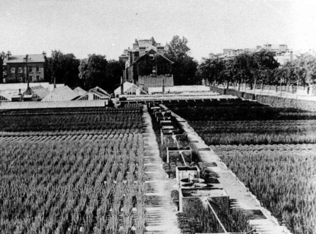
By 1881 they were listed in the census as being in Leyland Road – the numbering isn’t totally clear as the road was being developed and the house is just described as ‘The Nursery.’  This is pictured above (back middle), it was later numbered 72 and puts it now at the corner of Leyland Road and Alanthus Close. The nursery shown on an 1890s Ordnance Survey map. below, along with several other areas cultivated.

This would have been land leased from the Crown, part of the former Lee Green Farm (pictured below) which ceased operating in the1860s.  While the exact geography of the farm isn’t completely clear – it seems to have been a narrow farm covering land to the east of what is now Burnt Ash Road and Hill from Lee Green to around Winn Road.  Just a few hundred metres wide, it shrank rapidly as homes and shops were developed by John Pound following the arrival of the railway in Lee in 1866.  Land was also temporarily lost to clay pits and brickworks just south of Lee Station and north of The Crown.

In 1881 Maller was listed as a nursery man with 30 acres employing 4 men 8 boys.  The family included grown-up children Mary, Benjamin and Herbert – in the 1881 census at ‘the Nursery, Leyland Road’.

There had been  of significant reduction in labour since 1871 – 31 men to just 4 over 10 years.  This probably relates to the land they cultivated being rapidly lost to Victorian suburbanisation as streets like Dorville, Osberton and Leyland Roads were developed. 

Benjamin died in 1884 but the business continued as B Maller and Son afterwards, with Benjamin Boden Maller in charge – living variously at 107 and 111 Burnt Ash Road (there was access to the site from Burnt Ash Road too) and 72 Leyland Road. Benjamin Boden Maller died in 1913 although his son, also Benjamin, continued for a while.  However, in the 1939 Register he was listed as a Civil Servant living in Reigate.

So what did they grow? In 1879 an advert in the Kentish Mecury suggested the land cultivated from Wood Cottage (Burnt Ash Hill site) was for roses. The site around Leyland Road (listed as Burnt Ash Lane) was used for trees and and shrubs as well as having greenhouse plants and other plants that needed warmth – stove plants. While they cultivated Brockely Nursery they had moved from there as the Billinghursts (see below) were there by 1880 (1),

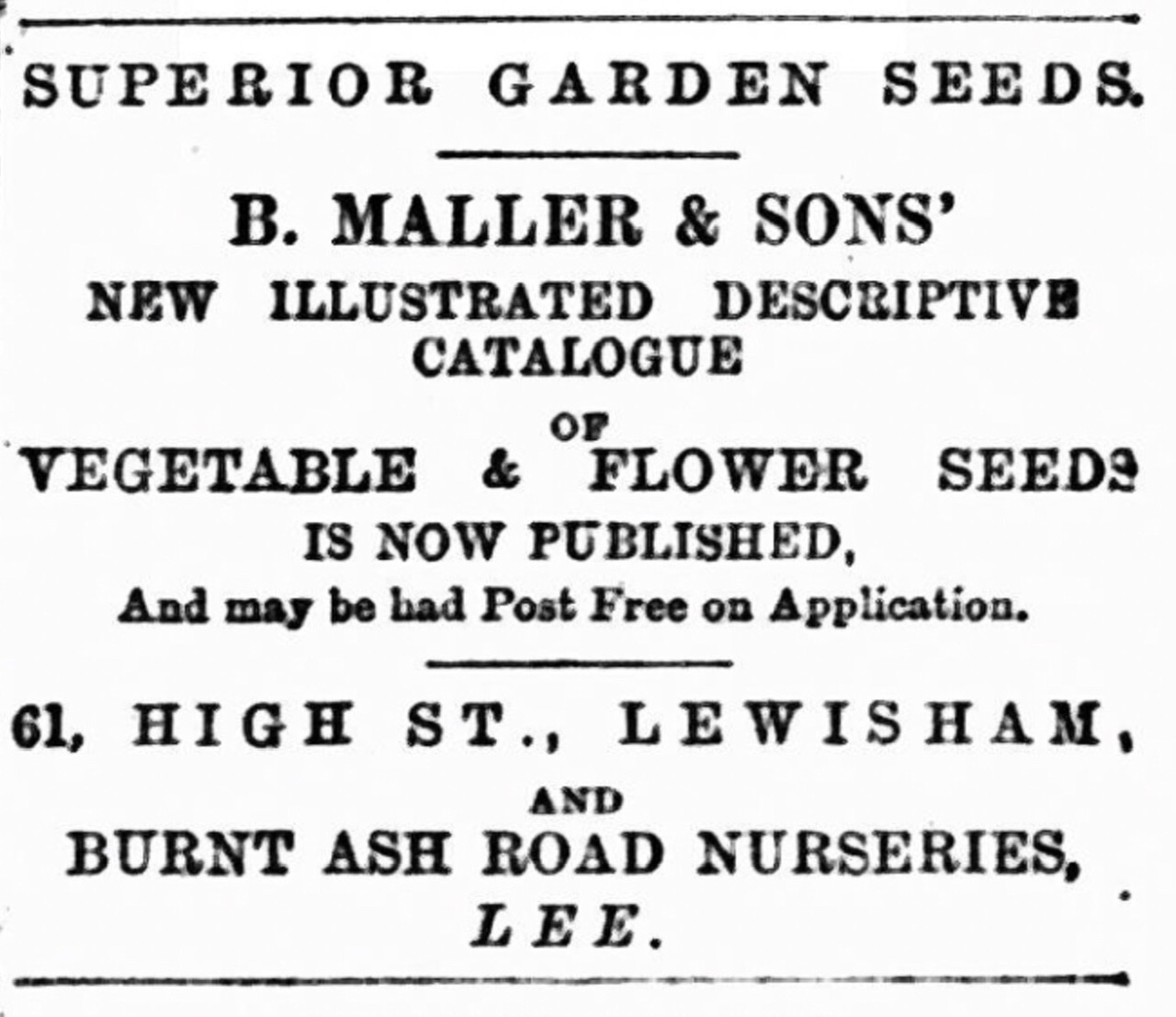
It seems that before the end of the century there was a change in focus with a lot of plants being grown for seed – they were regualrly advertising their illustrated seed catalogue to the gardeners of south east London and beyond (2).

In the early 20th century, they would also have auctions of surplus stock in September each year. The 1910 sale included 20,000 winter blooming heaths, gorse, winter aconites, ferns and palms (3).

The land that is now part of Alanthus Close seems to have remained with the Mallers until around the mid 1920s. On Burnt Ash Hill they will have added the land of the former brickworks less the frontage onto Burnt Ash Hill and a development next to The Crown centring on Corona Road.  This will have been an extension of the land cultivated from Wood Cottage.

It seems that the land was split three n the mid to late 1920s when the Mallers left.  There were different names at 107 Burnt Ash Road (May Scotland), 111 Burnt Ash Road (George Friend Billinghurst) and Norris Buttle at Wood Cottage.

May Clark Scotland was appropriately Scottish, born in Perth, she was running a florists at 111 Lewisham High Street by 1911, the name over the door was Alexander Scotland.

George Billinghurst was born around 1871 and seems to have spent his early years in Eliot Place in Blackheath, his father Friend Billinghurst was also a gardener.  There is no obvious link to the more well known Blackheath Billinghurst family, which included disabled suffragette (Rosa) May. They seem to have cultivated Brockley Nursery for a while (4), after the Mallers moved out, but family moved on to Croydon. By 1891 George was listed as a gardener, a decade later a florist and by 1911 a nurseryman living in Annerley Road.

Norris Buttle was living at 172 Ennersdale Road in 1901 and at 31 Leahurst Road in 1911 (these were probably the same house as the Ennersdale originally dog-legged around) – he was listed as a gardener then nursery gardener. 

With all three of them, details beyond 1911 proved difficult to work out.  Certainly none of them were at 72 Leyland Road – it was empty in 1939 as were 8 out of 10 the houses of that end side of the street going southwards.  It was a different picture going northwards.

Time was running out for the nurseries too, the land cultivated from Wood Cottage was lost in the 1930s as leases ran out and the Crown sold the land for development.  The land behind Wood Cottage was lost to the Woodstock Estate of Woodyates and Pitfold Roads.  Further south, the new South Circular and the developments around Horncastle and Kingshurst Roads, pictured above, further depleted the land.  The Cottage itself was lost to the new Roman Catholic Church of Our Lady of Lourdes – the church had acquired the land in 1936.

The land sandwiched between Leyland and Burnt Ash gradually was encroached upon with development at the southern end of Leyland Road although there were memories of roses being grown until the early 1960s when many Crown Estate leases ended. 

And finally, while no longer cultivated, there is a small piece of undeveloped land where the nursery was – the green space to the south of Alanthus Close. On some satellite images of the area in drought conditions show rectangles, probably the ghosts of greenhouses past – a little less clear than the prefabs around Hilly Fields.

,

Notes

  1. Kentish Mercury 16 August 1879
  2. Kentish Mercury 09 February 1894
  3. Kentish Mercury 02 September 1910
  4. Croydon Guardian and Surrey County Gazette 3 July 1880

 Credits

  • Census and related data come from Find My Past (subscription required)
  • Kelly’s Directories were accessed via a combination of Southwark and Lewisham Archives, with the reference to Lewisham High Street via the on-line collection of the University of Leicester
  • The postcard of Wood Cottage is via eBay in January 2021
  • The drawing of Lee Green Farm is from the information board at Lee Green
  • The photograph of the land between Burnt Ash Road and Leyland Road is part of the collection of Lewisham Archives, it remains their copyright and is used with their permission.
  • The Ordnance Survey map is part of the collections of the National Library of Scotland – it is used here on a non-commercial licence
  • The satellite image of Alanthus Close is via Apple Maps

Victorian Migration to Lee – Southbrook Road

A few months ago, Running Past covered migration to one of the working-class streets in Lee, Robertson Street, which was renamed in the 1880s and is now Brightfield Road. It was always the intention to look at look at some of the wealthier streets of Lee to see what the differences were. The homes we’ll look at this time are in Southbrook Road which were featured in an Edwardian postcard and, in 1881, would have been London suburbia.

The development of Southbrook Road had started at around the same time as the railway came to Lee – the station opened on 1 September 1866.  The houses at the Burnt Ash Road end of the street seem to have been built just ahead of this. 8 Southbrook Road was sold at auction with a lease of 74 years in 1889 – on the assumption that it was on a 99-year lease, it presumably had been built around 1864. As an aside, the rent was just £35 a year (1).

Like many Lee street names, the naming relates to the Baring family, who were Lords of the Manor; in 1866 the ‘Lord’ would just have been Francis Baring, the 1st Baron Northbrook. Southbrook, like Northbrook and Micheldever, they were parts of the family estate in Hampshire (2).  

The houses in the postcard seem to be on the ‘even’ side to the west of Wantage Road, with Manor Lane in the background.  If this assumption is correct, in the 1881 census, the houses pictured had relatively recently been sold and/or let, those at the Manor Lane end were still under construction.  In the 1881 census on the ‘even’ side while 32 to 48 had been let, 50 to 52 were noted as being ‘unoccupied.’  On the opposite side of the road 33 – 45 had been completed and, apart from 41 which was unoccupied all let or bought.  One of the houses in this group was sold for £710 in 1879.

The houses had been built by John Pound, who we’ve covered several times before.  It seems that they were finished off by John Urquhart Allan, an Aberdonian builder who was living at 26 Taunton Road In 1881. He’d arrived via Croydon, where he’d married Harriet from Dorset.  However, Allen wasn’t to emulate John Pound in terms of creating a large building empire, although the reason for his professional demise was the same – bankruptcy (3). Allan moved to north west London and restarted in his original trade, a carpenter; he stayed there until his death in 1915.

In the main, these were homes for young professionals – only two homes were ‘headed’ by someone over 37. Interestingly, two thirds of this group of households had extended families living with them. This is not a pattern noticed to any significant extent when looking at Victorian census data in the larger houses of Lee for other posts. Indeed, a decade later in the same houses it was quite uncommon.

The same style of houses had already been built to the east of Wantage Road – from electoral registers that are available on-line, it appears that there may have been sold and/or let let from around 1875. In these earlier houses there were fewer extended households and heads of household slightly older. One of those residents of the slightly older houses was someone we have come across before, William Marks, one of the founders of Northbrook Cricket Club.

This post will look at numbers 24-48 evens and 23-45 odds. For the purposes of tracking the ‘immigration’ to Lee we’ll look at the Head of household and their partner as one group (44 people), their children (32) as another group and their servants (26) as a third group. Disappointingly, some of the detail is absent with a small number of birthplaces – for example, details on the Swifts at 36 were reduced to England and a couple of others just London, such as the Mathams at 33 – although other data for them suggests they came from the City of London.

Looking first at the household heads and their partners; there are some significant differences to the working-class households of Robertson Street, later Brightfield Road.  As can be seen from the map above, none of the Southbrook Road residents had been born in Lee or Lewisham (it had been 16% in Robertson Street), while there were a fair number from the rest of London – in total 40% were Londoners, this was around 9% less than in the nearby working-class housing. A slightly smaller proportion came from the neighbouring counties of Kent and Surrey than in Robertson Street. 

Here the similarities end.  With Robertson Street many had come from rural communities in East Anglia; in Southbrook Road the none came from those areas.  Instead, the roots of 14% were in the south west of England, particularly Devon.  Another major different was the number with birthplaces in the Empire (14%); these included County Down and Dublin in Ireland, one from what is now Cape Town and two who were born in Jamaica (these are excluded from the map).  It is, of course, possible that the latter group may have been Black Caribbean, rather than there with trade or the colonial service, but this is much less likely but difficult to be certain about as ethnicity wasn’t recorded until the 1991 census.  

There were 32 children in the homes, this excludes three boarders and another child that was being looked after for a relative.  The data is somewhat skewed by one large household that had seven children all born in what is now Cape Town.   Of the other 25, 10 were born in Lee and 12 elsewhere in London – mainly in neighbouring areas such as Eltham, Camberwell and New Cross – indicating the stopping off points in the journey to Lee. 

William Marks was a silk merchant and his journey to 1881 Lee was shorter than many of the household heads – born in 1822 in Sheerness, his wife Jane came from Gravesend. Their children had all ‘flown the nest’ by 1881 but they’d been in Stepney in 1852 and Charlton by 1859 where they remained until a move to Lee around 1875 – he was on the electoral register in Lee then.

Martha Pollard was 34 in 1881 and was one of the more locally born residents, hailing from Woolwich.  She was married to John Pollard who was 52 in 1881 and came from Devonport, now part of Plymouth.  There is nothing obvious between his birth and the 1871 Census when the couple were living in Camberwell, he was working as a clerk at Somerset House.  They seem to have had several children when living in Camberwell, at least two of which weren’t on the census in 1881 (they could have been away from the property on census night).  They’d moved to Lee around 1876 as a daughter was born there.

As was common in the larger houses of the area, most of the houses had servants – the patterns of migration were much more similar to the working-class housing of Robertson Street, most were from London and the southeast, with a handful from the south west and Wales.

While not that much can be drawn into a small number of households in a couple of Lee streets, it certainly appears that the wealthier in Lee typically came from further away than their working-class counterparts.

And finally …. the view from about the same location as the postcard is not that different in early 2022 to that of over a hundred years before – the horse and cart has been replaced by a car but much else is similar due to the availability of off-street parking in the large front gardens.

Notes

  1. Kentish Mercury 19 July 1889
  2. Joan Read (1990) Lewisham Street Names and their Origins p50
  3. Kentish Mercury 11 December 1885

Credits

  • The postcard is from eBay in May 2020
  • The census and related data come via Find My Past (subscription required)
  • The maps are created using census data over Google Maps
  • The confirmation of the builders and the 1879 purchase price comes from the deeds of one of the houses.

One Night in the Blitz – the Air Raids on Lewisham of 8 December 1940

Last year Running Past looked at two of the most intense nights of World War Two bombing in Lee on the 27 and 29 December 1940.  We turn our attention to a night earlier in December 1940 when Lee, Hither Green and parts of the Corbett Estate were again hit  – the night of 8-9 December 1940 – most of the bombs fell in a short period around 11:00 pm on the Sunday evening.   

As was the case with the raids almost three weeks later, Lee wasn’t the real target and was a stopping off point on a major raid on London during which German bombers dropped over 380 tons of high explosive bombs and at least 115,000 incendiaries. 250 Londoners were killed on 8 December and 600 more seriously injured. Several streets in Lee, such as Brightfield Road (below), were hit in both raids.

As we have found with other posts on the Blitz, including the first night and the raids on 27 December and 29 December 1940, it is worth remembering that not every incident was reported to the Air Raid Precautions (ARP) HQ at Lewisham Town Hall, some being just reported to the Fire Brigade but others never going through official channels. This is particularly the case with incendiary bombs which residents were often able to put out themselves.

This particular night was clearly chaotic at the ARP HQ with some incidents clearly being reported and/or written up several times – as far as possible the narrative and maps have attempted to strip out the duplicates. There were around 70 incidents reported in just Lee, Hither Green and the Corbett Estate with no doubt lots not reported and large numbers elsewhere in the old Borough of Lewisham.

So, what were incendiary bombs? They were cylindrical bombs around 35cm long, and 5cm in diameter. Inside was a mechanism that ignited an incendiary compound that filled the cylinder, thermite, on impact. They were often dropped in ‘breadbaskets’ typically containing 72 incendiaries.

There appear to have been at least three ‘breadbaskets’ dropped on Lee at around 10:50 pm– one around Wantage Road, another on Burnt Ash Road, although the numbers were smaller there and a third around Brightfield Road. There were around 70 incendiaries that the ARP logged – with most, the note on the log was ‘fire put out without significant damage to property.’ The fires in Brightfield Road were of a different class to those elsewhere though– the ARP log noted that they were ‘distinguished’ – presumably a typo. Several of the houses in the postcard above were hit, whilst the photograph was taken over 30 years before, the street scene, that much will not have changed by 1940. The locations recorded from the raid in Lee are mapped below.

There were relatively few injuries – those that there were tended to be from the aftermath and/or trying to put out fires – four were injured in Burnt Ash Road, including a child who was blinded at 90 Burnt Ash Road and an ARP warden was injured in Micheldever Road.

At around the same time as incendiaries rained down on Lee several were dropped around what was then Campshill House in Hither Green Lane, Ryecroft and Campshill Roads (at the top of the map below).  A few minutes later there were a couple in the streets to the north of Brownhill Road – Ardgowan and Springbank Roads (there is a separate post on attacks on Springbank Road.) There were also incendiaries dropped in Fernbrook Road – 67 and 101 were both damaged along with another two at 127 Manor Park and Leahurst Road area (see Lee map above).  No doubt a few more fell but weren’t recorded.

At about 11:05 it seems that a ‘breadbasket’ was dropped on the eastern side of the Corbett estate with several hits on Verdant Lane and a lot falling in Minard Road (pictured below) – although they mainly landed in the street. Whilst this would have destroyed cars in 2021, this presumably wasn’t much of an issue in 1940.

While in the main, it was incendiary bombs that hit Hither Green, Lee and the Corbett Estate that night, there were a few high explosive bombs dropped too. The earliest was in Nightingale Grove at the junction with Maythorne Cottages (the eastern side of the ‘tunnel’ and current main entrance to Hither Green station.) It failed to explode, but the road was closed and, presumably, residents evacuated at around 10:00 pm. Three and a half years later, more or less the same location was hit by a V-1, causing several deaths and the destruction of a lot of homes.

Around 45 minutes later another one exploded at the junction of Mount Pleasant and Fordyce Roads causing a crater in the road and damaging the water supply.  Another unexploded high explosive bomb was reported at 59 St Mildred’s Road around 1:00 am, it was probably dropped earlier in the evening and the residents were evacuated.

The most destructive high explosive bomb was reported at 11:30 pm – at the junction of Dacre Park and Eton Grove, close to Lee Terrace.  Two houses were demolished and several others were damaged beyond repair.  Dacre Park was blocked for a while and four were reported as being injured. 

One of those injured was William John Sherriff, a 21-year-old merchant seaman from Port Talbot in South Wales; William was taken to Lewisham Hospital but died there the following day.

While of a similar size to the site from the Fernbrook Road V1 and several around Boone Street, the old Brough of Lewisham did not prefabs built on it; the site was cleared and flats built on it soon after the war, pictured below.

As noted earlier, Lewisham wasn’t the primary target of the raid – the bombers moved on towards central London where a high explosive bomb demolished the south and east sides of the Cloisters of St Stephen’s Chapel within the Houses of Parliament. The BBC buildings in Portland Place were badly damaged that night too.

Notes

  • In several locations the term ’many’ was used in the ARP log – this includes the both the eastern and western sides of Burnt Ash Road, Effingham Road (around the current Brindishe School), the eastern end of Burnt Ash. In these cases, I have assumed at least four incendiaries fell.  Some also aren’t exact – one group of four were noted as being on Micheldever between Wantage and Burnt Ash Roads.
  • The numbers are undoubtedly an underestimate – incendiary bombs that harmlessly fell in gardens or roads probably wouldn’t have been reported.

Credits

  • Most of the information for this post comes from the Lewisham ARP Log – it is a fascinating document, which is part of the collection of Lewisham Archives.
  • The postcard of Effingham Road is via eBay in February 2018
  • The maps are created via Google Maps

The Post Christmas Blitz on Lee Part 1 – 27 December 1940

Apologies if you’ve seen this before – the previous incarnation was partially deleted.
In the autumn of 2020, Running Past covered the attacks of the first night of the Blitz around Lee, Lewisham, Catford and Hither Green 80 years on. Over the next few months there were frequent attacks on the area – the worst night in the old Borough of Lewisham was probably the night of 8 to 9 December 1940. The Air Raid Precautions (ARP) Service Logs (an example of the log is shown below for 29 December 1940) noted for the night of 8-9 December

  • 126 high explosive bombs dropped;
  • 206 incendiary bombs – the number of both incendiary and high explosive bombs was almost certainly understated as the locations rather than numbers were often recorded;
  • 176 fires started – no doubt stretching the Fire Brigade to beyond breaking point;
  • 5 deaths; and
  • 175 injured – this was almost certainly a big understatement as at many locations injuries were ticked rather than having numbers.

However, around Lee some of the worst nights were at the end of December 1940 in two posts we’ll look at the nights 27/28 and 29/30 December where there were two nights of very heavy bombing.

There had been two quiet nights on Christmas Day and Boxing Day 1940, it was the lull before the storm with the night of 27/28 December being one of the heaviest nights of the blitz in Lewisham.

While there were attacks earlier in evening in Brockley, the first attacks on Lee was a series of incendiary bombs which hit at 19:51; one was at 33 Burnt Ash Road – a large house demolished after the war in the large scale demolitions of houses at the end of leases by the Crown Estate. There was no note of damage, but in the LCC Bomb Damage map the house ended the war with general, not structural, blast damage (1).

The other was at Reeds of Lee Green, a long standing drapers and furnishers that dominated the south east quadrant of Lee Green, straddling both Burnt Ash Road and Eltham Road – it was around 50 metres from 33 Burnt Ash Road. There was no damage marked there on the LCC Bomb Damage maps (2).

The final one of trio was at 57 Leyland Road (opposite the present day Alanthus Close) which was dealt with by officers from Lee police station.

Soon after at 20:05, another incendiary bomb was dropped close by in Burnt Ash Road between Southbrook and Micheldever Roads – there was a small fire which was quickly put out though.

There were several attacks on just after 9:00 pm on the then new homes on Upwood Road, (above) 34 and 22 were specifically mentioned but a couple of other incendiaries were reported as well. A hundred metres of so away 73 Leyland Road was hit by another incendiary. The was another dropped on Leyland Road between Dorville and Osberton Road – presumably somewhere around the current Carsten Close. With all of these the fires seem to have been put out by ARP fire wardens.

At around 9:12 pm, 41 Dorville Road and 36 Cambridge Drive were hit by incendiaries – as with the others in neighbouring streets they were put out by ARP wardens who had a busy night. The latter is a large surviving Victorian house, the former lost to the large scale redevelopment of Crown Estate land in the 1960s, but will have looked similar to the very different street scene from a few decades before.

At around 9:40 at least five bombs were dropped around Aislibie Road. One was in Manor House Gardens, which was home to three air road shelters. Fortunately the high explosive bomb hit a shrubbery between the shelters with only limited damage. Had there been a direct hit the loss of life could have been considerable as happened at Albion Way in Lewisham town centre on 11 September 1940 where 41 died.

A hundred metres or so away, 14-20 Lampmead Road (between Aislibie and Lenham Roads) were hit. Presumably the impact was in the road as none of the houses was destroyed although the ARP log noted that walls on all of them were cracked. Numbers 18 and 20 have survived but 14 and 16 were destroyed by a V1 flying bomb later in the war – the circle on the map.

More serious damage was around the corner in Aislibie Road with number 50 being hit directly and largely demolished and the houses either side rendered uninhabitable. The shading on the LCC bomb damage maps is incorrect here – the Ordnance Survey map of 1949 notes ‘ruins.’

Another bomb hit a few doors up, damaging 38 Aislibie Road- it wasn’t one of the houses destroyed during the war and was marked as blast damage – minor in nature on the LCC bomb damage maps. (3). If there was any serious damage it may have been made good by the end of the war.

In the same attack there was serious damage to the odd side of the road too, 17 to 23 had their chimney stacks knocked of; but 25 to 29 were left in ruins. The site had been cleared by the time the Ordnanace Survey cartographers mapped the area in 1949, but unlike similar small sites, such as Fernbrook Road, wasn’t used for prefabs. Again there were no reports on casualties here.

At around 9:45 there were at least four high explosive bombs dropped in the area around Winn Road area between Guibal Road and Senlac Raod.  The one at 87 Guibal Road failed to explode and the houshold had to be evacuated temporarily while it was made safe. The one at 105 Guibal damaged water, gas and electricity services, with the others not seeming to do much damage other than to gardens.

At 9:55 another high explosive bomb was reported as hitting Manor Lane – 50 was described as being ‘demolished’ and 48 and 52 rendered uninhabitable. Unless these were rebuilt in in exactly the same style as the W J Scudamore originals, it may be that the report was overstated. While there has clearly been some patching of walls, original features seem to remain.

Around 10:00 pm a small explosive bomb hit the old St Margaret’s Churchyard (pictured above) leaving a small crater and several damaged tombstones. A few minutes later there were a couple of incendiary bombs dropped on Lee High Road close to the current Mercator estate – an area that was to be devastated later in the war.

Overall, that night in the old Borough of Lewisham 

  • 97 high explosive were dropped;
  • 112 incendiary bombs fell;
  • 91 fires were started;
  • 3 died;
  • 12 were injured, this is almost certainly an understatement as some just ticked the box rather than entering a number; and
  • 12 were trapped by debris having to be rescued by emergency services.

It wasn’t just Lewisham that was attacked that night, The Times for the following day noted that ‘the raid equaled in intensity, but not duration, some of the heaviest attacks on the capital….from widespread areas came the same report of enemy aircraft flying over almost continuously dropping incendiaries followed by high explosive bombs.’ (4)

Whilst the following night seems to have seen another lull with defence guns silent (5), the Sunday evening of 29/30 saw the bombers return with in what was described in central London as the Second Great Fire of London but also saw numerous bombs dropped on Lee; we’ll return to this is the second part of the post.

Notes

  1. Laurence Ward (2015) The London County Council Bomb Damage Maps 1939-1945 p116
  2. ibid p116
  3. ibid p185
  4. The Times Saturday December 28 1940
  5. The Times Monday December 30 1940

Credits

  • Most of the information for this post comes from the Lewisham ARP Log – it is a fascinating document, which is part of the collection of Lewisham Archives. It isn’t a complete record – some incidents were reported to the Fire Brigade rather than the APR and some incendiaries were dealt with by residents or Fire Wardens without ever reaching the ARP service – this is particularly the case on busy nights such as this.
  • The map is from the London County Council Bomb Damage Maps, 1939-1945 – permission has been given by the London Metropolitan Archives, the copyright owners of the map, the to use the image here.
  • The photograph of Lee Green and the page of the ARP Log are both from the collection of Lewisham Archives, both are used with permission and remain their copyright.
  • The postcard of Dorville Road is via eBay in December 2019

1-19 Burnt Ash Road – Shopping Before the Leegate Centre, Part 2

In the first part of this post we looked at the shopping parade of 1-19 Burnt Ash Road, following its evolution from housing built on the site of Lee Green Farm until the outbreak of World War One. As had been the case with the shops opposite, it seemed to be a thriving parade at this stage – empty shops something of a rarity, certainly when compared with Manor Park Parade, closer to Lewisham. We continue the story, taking it to the the end of the parade when the bulldozers arrived, ahead of the building of the Leegate Centre.

Bank House

The Bank had opened around 1906 as a branch of the London and Provincial Bank; there was a name change in 1918 following a merger with the London and South Western Bank, who had a branch that we’ve already covered at the junction of Lee High and Brightfield Roads. The combined name was the snappily titled London, Provincial and South Western Bank.  Probably by the time the sign writers had finished the new title, it had become redundant as it was taken over by Barclays later in 1918.  It seems to have stayed a bank until the parade was demolished, although the address changed to Eltham Road in the mid-1930s.

Clock House

The watchmaker and jeweller Robert Fielding who had been at the Clock House from around 1906, remained there until the late 1920s.  Fielding would have been 80 in 1930 and presumably retired to Bromley where he died that year. 

There was a new business, a chemist that was there until at least the beginning of World War 2, run by W George, latterly trading as George’s Chemist.   It was bought out by the national chain Bannister and Thatcher, who eventually became part of Lloyds Chemists.  Oddly, at around the same time they opened another shop on the opposite side of the road in what was originally called Burnt Ash Parade – the late 1930s development in the southwestern quadrant of Lee Green.  They remained at the Clock House, latterly referred to as no 1, until the end of the parade.

1a Burnt Ash Road

1a was referred to before and after World War 1, but it seems likely that either the numbering changed or there were errors in the recording as it was referred to as being the premises of  CH Reed & Co and then Griffiths & Co House Furnishers.  They generally seem to have been at No 1 so we’ll refer to them there.

However, by 1925 there was some clarity and the firm John Lovibond was trading out of 1a. Their managers seemed to live on site; in 1939, it was Harold McLuskie who lived there with wife Constance, a lodger and three others, probably children.

John Lovibond & Sons were the owners of the Greenwich Brewery at 177 Greenwich High Road, almost next to the station, although it was a firm which originated in Somerset.  They stopped brewing in 1959 to concentrated on selling wines and spirits through a chain of shops, including the one in Burnt Ash Road.  They continued there until the demolition of the shops in the mid-1960s; the remaining shops were sold to Wine Ways in 1968, and many subsequently on to Victoria Wines. 

1 & 3 Burnt Ash Road

We’d left 1 and 3, along with a big chunk of the shops around the corner in Eltham Road under the stewardship of Griffiths & Co.  They had bought out the drapery, furnishing and ironmongery empire of C H Reed from Charles Reed’s son William around 1905.

By 1920 the shops had been sold back to the Reeds – initially  trading as William Reed and then known as Reeds (Lee) by 1925.  The second name change reflected the death of William in 1924.  He was succeeded by his brother Ernest, who seems to have run the business until the 1950s.  It appears likely that the site was redeveloped at around the time of the re-acquisition to allow for a single premises straddling the corner of Burnt Ash and Eltham Roads, although the Bank remained.

By 1960, the shop front was home to Barker Clark Estate Development Company, perhaps a firm related to the creation of the Leegate Centre

5 Burnt Ash Road

We’d left the shop front being run by a firm of builders’ merchants called Barnes Brothers as World War 1 approached.  By 1916 though the premises were being used by a firm of ironmongers – a trade that was to continue until the bulldozers demolished the parade in the early 1960s. 

Initially, it was run by Holeman and Hyland. The Holeman was Charles Herbert Holeman.  Charles was born in Peckham in 1878 and had been living in East Dulwich, working as an electrical engineer in 1911.   In 1939 he was living ‘over-the-shop’ with wife Janet plus two adult daughters, one of whom was a clerk at a draper’s shop, perhaps for Reeds next door – it was just Charles name over the door by the outbreak of World War 2 and it probably remained there until his death in 1957. 

The business continued as Godfreys until the parade’s demise.

7 Burnt Ash Road

Before the outbreak of World War 1, number 7 was a florist – Harriet Walton had taken over the shop after the death of her husband James in 1913.  It was a well-established business that had previously traded round the corner in Eltham Road’s Eastbourne Terrace.  By 1930 their son Walter was running the business.

The Waltons sold up by 1935 – they remained in Lewisham for the rest of their lives, Walter was a typist living in Heather Road off Baring Road with his mother in 1939.  The new name over the door was that of Francis Blake a fruiterer; there was little longevity in the ownership though as by 1939 there was a new name– Lee Green Fruit Stores.  The proprietor was Thomas Jamison, or Jameson, (aged 58 in 1939) along with his wife Beatrice (38) and 6 children, 4 of school age and a son who worked in the shop, Alfred.  Thomas died in 1944 but the business carried on until the parade was demolished – if it stayed in the family, it may well have been Alfred running it until the early 1960s.

9 Burnt Ash Road

In the first part of the story of the parade it was noted that number 9 was one of those retail rarities, a shop that stayed in the same trade throughout its life – that of a butcher.  Frederick Head from Christchurch in Surrey had been there since around 1900, he remained there throughout the First World War and beyond.

By around 1925, Frederick sold up to Grace Mary Plummer. Grace Mary Plummer probably lived in Beckenham as there was someone there of that name in 1939, although listed as carrying out unpaid domestic duties rather than being in the meat trade.  She died in 1976 with an estate of around £70k.  This may not even be the same person, but nothing else is obvious from online searches.  However, it was her name above the window until the wrecking ball destroyed the terrace.

11 Burnt Ash Road

Like its next-door neighbour at number 9, 11 remained in the same trade for the entire period after World War 1, a fishmonger.

While Sparks Bros. had been running the business before World War 1, by 1920 Thomas Butler was selling fish, replaced by James Delliston in the early 1930s.  Delliston seems to have sold up to Mac Fisheries before the war and was still a fishmonger living in Tressillian Road in the 1939 Register.

Mac Fisheries started as a vanity project of Lord Leverhulme of detergents fame, who bought initially the Scottish Isle of Lewis and then part of Harris after a boat trip in the Western Islands.  His plan was to develop a fish-based industry and as part of this he started buying up independent fishmongers throughout Britain, rebranding them Mac Fisheries from just before World War 1. Lever Brothers got rid of the fish processing elements of the business after Lord Leverhulme’s death in the 1920s.  The chain, and no doubt the shop on Burnt Ash Road, benefited during the World War 2 when fish, unlike meat, wasn’t rationed.  Elsewhere Mac Fisheries expanded into other aspects of food sales but the small footprint of the shop at Lee Green probably prevented this.  They were to remain at No 11 until the parade was demolished though.

13 Burnt Ash Road

Before World War 1, the chain Hudson Brothers was running a grocery and provisions business.  They remained there until the early 1920s when name over the grocery changed to William Cullen, who also had a shop close to the railway bridge near Lee Station where he combined a grocers with a Post Office.

The expansion by William Cullen was a short term one as he’d retreated back to the Post Office by 1935 and the shop appears to have been empty during much of the 1930s, something of a rarity on the parade, as was the case over the road.

No one was living there when the 1939 Register was collected as World War 2 started, although a draper Mrs Fenn had opened a shop by 1940.  It was a business didn’t last the war out, as Morgan Brushes, a brush manufacturer had their name painted over the window by VE Day – hopefully using one of their brushes, they lasted into the 1950s.  Robert Lyas, a fruiterer, seems to have been the last business to operate before the parade was lost to the Leegate Centre development.

15 Burnt Ash Road

At the outbreak of World War 1, we’d left number 15 split – 15 was a confectioner’s and 15a was a dyers and cleaners trading as Chambers and Co. – that was still the case in 1920.  The confectioner’s remained too but it was now Amelia Fairburn in charge.

By 1930 Amelia Fairburn had moved on replaced by a Mrs Monk at the confectioners; by 1935 Alice Watkins was there, but her tenure was a short one as Daisy Gadd was running the shop by the outbreak of World War 2. She lived there with her Lighterman husband George (42) and a couple of lodgers.  

Despite the difficulties that wartime rationing will have caused her business, she continued until the 1950s when John Cawthorne took over the business until the end of the parade.

In the mid-1920s and early 1930s, 15a was briefly home to a blouse maker, Madame Iris. It then saw an extension from 17 of Walter Taylor’s photographic business.  After this it returned to being a dyers and cleaners – initially named after the Georgian dandy and socialite, Beau Brummell, who had no obvious links to Lee.  By the end of the war it had taken the name Zip French Cleaners, which it retained until the demolition of the parade.

17 Burnt Ash Road

Like several shops at this end of the parade, 17 was split into two. By the middle of World War 1 and into the interwar years John Allibone, a boot repairer from Northampton was trading at 17a, he’d been based on the Old Kent Road in the 1911 census.  It was a business that lasted there until the late 1920s. 

The partial shop front at 17a was taken over by a Corn Merchant’s business trading as William George Sweet, which was to stay at 17a until the wrecking ball arrived. It seems William George Sweet grew up in Prospect Terrace in the north eastern quadrant of Lee Green and had a long standing Corn Merchant’s shop in Brightfield Road from around 1881.  He died in 1915 so it can be assumed that the family business was continued in his name from around 1930 at 17a. What is slightly odd about this business is that Corn Dealers were a business type that had generally died out during the inter-war period with the switch from horse to the increased horse-power of the internal combustion engine.

After being empty during World War One, the other half of the shop, 17, was taken over by Photographic dealer Walter Taylor by 1925, who expanded into 15a by 1930.  He’d gone by 1935, with the tenure on the shop front taken over by a hairdresser trading as ‘Lydia’ which was to remain on the parade until its end. The person behind the name in 1939, at least, was Gladys Hardine, later Horton.  She lived until 2004, so may well have had the business for 40 years.  

19 Burnt Ash Road

At the beginning of World War 1, George Neal had been running a saddler’s at 19, the business seems to have continued until around his death in 1921. After that, the business carried on at 19 reverted to a previous one, cycle sales and repairs run by Reginald George Littlewood  However, there was competition from F A Lycett in Lee Road, who eventually moved to 30 Burnt Ash Road, this may have caused Reginald to change business to wireless supplies by 1935 (pictured on the sign in the photograph above). By 1940 the shop was empty through.

Post-World War Two, the name over the window was Sentinel Products, what the products sold were isn’t clear though, possibly it was a locksmith.  They had been replaced by Frank Sutherland by 1950, but it isn’t clear what he was a purveyor of though – it was listed in Kelly’s Directory as a ‘Miscellaneous Dealer.’ Frank was there when the parade closed in the early 1960s.

_

We’ll cover the Leegate Centre (pictured above in 2016) at some stage in the future – although we’ll look at the shops on Eltham Road before we do that. However, what is interesting at 1-19 Burnt Ash Road is that after World War 1, while there were significant changes going on over the road there was much more stability here – while some names changed, the traditional shops remained – the fishmonger, butcher, fruiterer, wine and spirit merchant, confectioner and women’s hairdresser. 

The ‘story’ of the parade has been pieced together using Kelly’s Directories held by Southwark and Lewisham Archives – generally looking at every 5th year since the parade opened for business from 1896.

Pictures and Other Credits

  • All the census and related data came via Find My Past (subscription required)
  • The Kelly’s Directory data was accessed via Lewisham and Southwark Archives
  • The black and white postcards and photographs of the parade are from the collection of Lewisham Archives, they are used with their permission and remain their copyright

1-19 Burnt Ash Road – Shopping Before the Leegate Centre, Part 1

A while ago we looked at the shopping parade of 2-30 Burnt Ash Road, from its development in the late 19th century, to its loss to Penfolds and later Sainsburys.  We now cross over the road to look at the shops on the other side of the road, that were eventually lost to Leegate Centre (pictured from 2016).

While the 1863 surveyed Ordnance Survey map still showed Lee Green Farm (pictured below), its days were numbered – its last farmer, Richard Morris, had, or was about to move, on to Blackfen. His father, William, had leased land from the Crown Estate for several decades, before moving on to College Farm at the highest point on Burnt Ash Hill where he died in 1851.

The developer of the south eastern quadrant of Lee Green, where the farm buildings still sat in 1863, was a name that will be familiar – John Pound, who developed much of Grove Park and south Lee. Work seems to have been completed around 1866 – there were shops at Orchard Terrace on Eltham Road and houses in Crown Terrace on Burnt Ash Road (then called Lane). The Orchard relating to the previous land use and the Crown, the landowner. Burnt Ash Lane/Road was the boundary between the lands of the Crown to the east, which had been part of the estates of Eltham Palace, and the Northbrook estate to the west

The houses were terraced and much smaller than those opposite which were built a few years earlier and were also to become shops.  In the 1871 census, the lower numbers near Lee Green tended to be working class and manual occupations, slightly wealthier further south included articled clerk, solicitor’s clerk but nothing that grand – certainly compared with original occupants over the road.  Little had changed a decade later although there had been a gradual shift to multiple households living in the houses – for example there were four households at 2 Crown Terrace. 

The conversion from houses to shops started to happen in the 1890s.  In the 1891 census all the buildings seem to have been residential but by 1894 well over half the group now had shop fronts and a couple of years later all of them were retail outlets.  We’ll look at them in turn – focussing on, in this first part of the story, on the period up to World War One.

The numbering changed a little in that the building on the corner was originally part of Eltham Road, but that changed with the building of a bank around 1911.  To avoid confusion, as far as possible the numbering referred to will be that from the Edwardian era onwards.

Bank House

While the rest of the Parade dated from the 1860s the Bank was much later – probably built around 1906. It seems that what was once 2 and 4 Eltham Road was redeveloped at that point, it was a building  listed in both Eltham Road and Burnt Ash Roads in Kelly’s Directories, its manager in 1911 was Harry Kitto.

Clock House

Like Bank Buildings, the part of the parade known as the Clock House dates from around 1906, presumably part of a redevelopment of that south eastern corner of Lee Green.  It was so called because of the clock that its first occupant advertising his trade – Robert Fielding, a watchmaker. Fielding was 61 and in 1911 was living in one of the larger houses on Lee High Road with his wife, Georgina, a servant and two adult daughters, one of whom assisted in the shop.  Before his move to Clock House, he had been at 141 Lee Road, next but one to Osborn Terrace for around a decade before.

It was a business that had run in the family – his father had been a jeweller and watchmaker but had died young and the business was taken over by his mother in Montpelier Vale in Blackheath, probably from the late 1850s.  

The Clock House seems to have been shared with Horace L Murray Shirreff’s Electron Cycle Co (see 7 below) until around 1916 but no one else is mentioned after then so presumably Robert Fielding used the whole shopfront.

1a Burnt Ash Road

This seems to have remained a house much longer than the rest, possibly also acting as a base for a business.  From 1871 it is listed at the home of G Bush and Sons Builders, run by George Bush – it may have been the case that he had been the builder of Crown Terrace for John Pound.  There were 6 children there with George in 1871, and a decade later he is noted as ‘employing about 35 men.’ His daughter was a drapers’ assistant, perhaps from George Gooding over the road. George Bush died in 1902 and the business was continued by his son who lived in Elswick Road in 1891, listed as a stone mason.  The business continued during the decade of George’s (Senior) death, but the shop front was empty by 1911.

1a was referred to before and after World War 1 but it seems likely that either the numbering changed or there were errors in the recording as it was referred to as being the premises of  CH Reed & Co and then Griffiths & Co House Furnishers.  They generally seem to have been at No 1 so we’ll refer to them there.

1 & 3 Burnt Ash Road

Number one was first mentioned in 1896 with a name that this corner of Burnt Ash Road and Eltham Road became synonymous with – Reeds, for years it was often referred to as ‘Reed’s Corner.’  The ‘Reed’ initially referred to C H Reed & Co and the C H Reed was Charles Henry Reed.  He has been born in 1839 in North Cornwall, having moved to Lee Green in 1866

By 1871 Charles Henry, was living at the next parade along, Eastbourne Terrace, with his wife Maria (probably nee Nichols), also from Cornwall; there was also a niece and 12 employees. Whether all employees these actually lived on the premises was debatable, a decade later, there were two different nieces and 49 staff. By 1881 he had a trio of shops on trading as a draper, furnisher and ironmonger. 

No longer there in 1881 though was Charles wife, Maria, she was living in Forest Hill with Charles William, born in 1873, sometimes referred to as William, along with a daughter Maria (seemingly later referred to as Beatrice, 1875) and Ernest (1881). Whether they were separated or not it wasn’t clear, but the position was the same in 1891, with 63 listed as living at Eastbourne Terrace, and Maria in Brockley.

The inclusion of 1 and 3 Burnt Ash Road into Charles Reed’s empire came in the mid-1890s – it was the furnishing element of the business that was moved around the corner from Eltham Road.  Charles died in July 1895 shortly after the expansion.  The net effects of his will were £28,117 – a very significant amount of money in 1895, both his son Charles William Reed and an Alfred John Reed (given other recording errors this may well be Ernest) seem to have been the main beneficiaries.  There was no mention of Maria, although a two-year-old Thomas Battyll Hodson, a two-year-old with no obvious connection to the Reeds was though.

(Charles) William continued to run the shops for a decade after his father’s death but sold them to Griffiths & Co.  around 1905, it was a name that dominated the south east quadrant of Lee Green for the next 20 years or so.

5 Burnt Ash Road

The first shop-front type of business operating out of 5 was the boot and shoemaker Josiah Tylor who was there from the mid-1890s.  The shop was doing well enough by 1901 to have a manager Thomas Wisdom, who was there with his wife Maude and a young son and sister in law.  Nothing is known of the owner whose name stayed over the door until around 1905.

It seems to have been very briefly an auctioneer around 1907 (1), a firm called Bell and Rainer trading as Lee Green Auction Rooms.  However, other than a few press reports that year they didn’t leave much of a trace.   It was the base of Barnes Brothers who were builders’ merchants by 1911 although it no one was living there when the census enumerators called that year.

7 Burnt Ash Road

In its early years it went through several names on the shop front – in 1894 it was W J Tournour, a house furnisher, followed in 1896 by George Lewis, a draper, and then Walter Woolverton, another draper in 1900.  All will have had competition from shops opposite, in Eltham Road and further down the parade which may explain their lack of longevity.   George Lewis seems to have suffered the ignominy of having his stock sold at ‘prices considerably below cost’ by Reed’s, still in Eltham Road at that point, in September 1897 (2). 

By 1898 the name above the door was the Electron Cycle company who manufactured bicycles.  The name behind the branding was Horace L Murray-Shirreff. Along with his wife Mahala, the family came from Uxbridge where their son was born in 1896.   They had moved to Lee Green by the spring of 1898 as his machines were twice ridden to victory at the Sportsbank Street Velodrome in Catford  (pictured below) over the Easter Bank Holiday, once by Horace himself (3). Electron had moved on within the parade by 1911 as they were listed within the Clock House (see above) in the Kelly’s Directory.  The sojourn at the Clock House was probably a short one as in the 1911 he’d moved to Staines and was listed as an inn keeper in the 1911 census.

By 1911 James Walton was trading at number 7 as a florist; he had had a business just around the corner in Eltham Road’s Eastbourne Terrace in previous censuses, listed variously as a florist and nurseryman.  In 1911 he was there with his second wife, Harriet and three children, two of whom helped in the shop.  James died in 1913 aged around 79, but the business stayed in the family initially in the name of Harriet running it as war broke out. 

9 Burnt Ash Road

Number nine was a rarity in that throughout its life as a shop it was to stay in the same trade – a butchers, there were also only three different names over the window in its 65-year life.  The first of these was the shortest lived, Colonial Meat Stores, who operated there in the mid-1890s, which seemed to be a single shop rather than any form of chain. 

Frederick Head was there by the turn of the century and in 1901 was 47, he hailed from Christchurch in Surrey, and was there with his wife, Martha 47 and 5 children of mixture of ages who were all born in Kings Lynn there as was a servant employed by them. The two eldest sons were both helping in the shop.  By 1911 the rest of the family had moved on, but Frederick and Martha were still running the business.

11 Burnt Ash Road

Like its next door neighbour at number 9, 11 was almost a single trade, a fishmonger, although there were a few more names over the window.  The ‘almost’ is because the initial traders, Green and Co, started life as a fruiterer around 1896 but by 1900 was trading as a fishmonger.  Perhaps they couldn’t cope with the competition from the already established M J Martin over the road who was a fruiterer and florist. There was though a lack of fishmonger though, on both sides of Burnt Ash Road, so Green and Co adapted to meet a gap in the market.

Who Green & Co were isn’t clear, certainly in 1901 the shop was managed by Surrey man E M Mankleton along his wife, mother, four children and a lodger who worked in the shop.

There was a new name over the window by 1911, Sparks Bros. In the census that year Frank Sparks was the fishmonger, the fishmonger’s wife was Sarah and Henry, the brother in the ‘Bros.’ were also there. 

13 Burnt Ash Road

Hudson Brothers were a chain of provisions dealers, that existed from the 1870s, they were based in Ludgate Hill and had a dozen or so stores in and around central London, many close to stations.  They also had a few in the then suburbs like Lee Green by the mid-1890s, where the shop opened around 1894.  They were to remain on the parade until the early 1920s. They refurbished the shop in 1908 as the advert to the left shows (4).

15 Burnt Ash Road

This was another shop that started life as a draper’s shop, initially Thomas & Co from around 1896, but by the turn of the century W Sanders Pepper (40), along with his wife Ella (37) who both hailed from Northamptonshire, they had arrived via Battersea where two of their children born.  A shop assistant and a servant were also part of the household in 1901.

Around the end of the first decade of the century the Peppers moved on, possibly struggling with competition from drapers shops opposite, in Eltham Road and further up the parade.  

The new name at the front by 1911 was Ethel Higgins who was a confectioner; there had been one next door, but it had closed a year or two before.  Ethel was a widow from Greenwich and lived there with her daughter.  Whilst names changed periodically it was a business type that remained until the end of the parade, by 1916 Elizbeth Stevens was running the confectioner’s shop.

Around 1911 the shop front seems to have been ‘split’ and 15a appeared – the dyers and cleaners, Chambers and Co.

17 Burnt Ash Road

17 started its life as a shop around 1896 as a stationer’s run by Thomas James Watts; it wasn’t a business to last long though.  By 1900 Annie Palmer had taken over the shop but changed the business to a confectioner, she was a widow who a decade before had been living in nearby Wantage Road. By 1905 her husband Samuel Evans Palmer was running the business, she died in 1908, and Samuel had gone by 1911 and was a Peckham based ‘Coffee House Keeper’ by then – whether this was a temperance one like one in Lee High Road isn’t clear.

By the census in 1911 Flora May Phillips, a tailoress from Bromley was there on her own, although the name over the window was Frederick May. 

Like number 15, the arrival of a confectioner saw the shop split into two – dressmakers Mabel and Eleanor Harkness, there in 1900.  Empty in 1905, Florence Wood, a milliner, was trading from there in 1911. 

19 Burnt Ash Road

The first shop at 19 opened around 1896, a Wine and Spirit merchants run by Cockle & Sons.  It didn’t last long and neither did the next tenant the Electron Cycle Co.; as we’ve seen Horace L Murray Shirreff’s business popped up in three locations on the parade in little more than a decade.

The next name over the window was that of Neal and Son, who were there by 1905.  It was a trade that reflected the era, saddlers, and will have complemented William Brown’s corn dealers over the road who sold the feed for the horses.  George Neal had been born in 1871 to a family in the same business and operated in Prospect Terrace next to the New Tiger’s Head, like William Sweet at 17a.  George was in ‘Son’ in Sons.  George was operating in Turner Road (now Dacre Park) in 1901 and moved back to Lee Green by 1911 where he was to continue at the southern end of the parade until around his death in 1921.

The parade will be returned to after World War One, when the second part of the story will take it to the stage that the bulldozers moved in ahead of the construction of the Leegate Centre. 

The ‘story’ of the parade has been pieced together using Kelly’s Directories held by Southwark Archives – generally looking at every 5th year since the parade opened for business from 1896 along with census records before that.

Notes

  1. Kentish Mercury 29 November 1907
  2. Kentish Mercury 24 September 1897
  3. West Middlesex Gazette 16 April 1898
  4. Kentish Mercury 2 October 1908

Pictures and Other Credits

  • All the census and related data came via Find My Past (subscription required)
  • The Kelly’s Directory data was accessed via Southwark Archives
  • The black and white postcards and photographs of the parade are from the collection of Lewisham Archives, they are used with their permission and remain their copyright
  • The photograph of the Velodrome is via eBay in February 2016
  • The picture of the farm is from the information board at Lee Green

Penfold’s – A Carting and Car Firm Part 1 – 1850s to World War One

We have covered Penfold’s Motors on several occasions, most recently in relation to their showroom on Burnt Ash Road. They were a family firm that evolved from Victorian carting to the sale of 21st century cars, but in the latter decades they have left an indelible mark on the Lee landscape through the development and sales of the land they had previously used.

This first part will look at the origins of the firm in Deptford, Greenwich and Lewisham up until just after the First World War; the second part focusing on the years after until the firm was finally wound up in 2016.

The family links to the haulage and carting trade seem to go back to Walter George Penfold who was born in Deptford in 1852, his father was a ‘dust collector’ in 1861 – in more modern parlance a refuse collector or bin man – a typical picture of Victorian dust collectors is below. The family was living in Knotts Terrace, a small street that once ran off Tanners Hill. Walter (1852) was the youngest of six children at home.

Walter (1852) was working as a builder’s labourer in 1871 living with his widowed mother and an older sister, still in Knotts Terrace. By 1881 though he had married Amelia (nee Gosling) were living in Charles Street in Deptford working as a coal porter, this was presumably working on the nearby Thames waterfront. They had two children, imaginatively Amelia (1878) and Walter Henry (1879). Like Knotts Place, the street is no longer there, it is at the northerly end of Margaret McMillan Park (pictured below).

A decade later, in 1891, the family was in Ffinch Street, off Deptford High Street, and Walter (1852) and Amelia now had six children, with Walter listed as a Carman – generally a driver of a horse and cart, although it could be the hire or any combination of driver, horse and cart. This was the beginning of the business that was to eventually become motor traders. It was a small house, close to the railway which survived the Blitz but not post war slum clearance, it is now a neglected bit of ground with several seemingly abandoned cars dumped on it.

By 1893 they had a yard at Greenwich Wharf (at the end of Pelton Street) and successfully tendered for providing an unspecified number of carts, horses and drivers for the local authority (1).  The Wharf was lost to housing a few years ago, having been a behind corrugated iron fencing for years before that.

By 1901 the family had moved to 64 Banning Street in Greenwich, Walter George (1852) was listed as a Cartage Contractor with Walter Henry (1879) and Arthur (1881) listed in the census as a Contractors Journeyman, Carman.

Banning Street was built in various stages during the nineteenth century and like other streets between the river and Blackwall Lane was ‘infilled with small workshops …. all sorts of “back street” industries in among the houses.’ The Penfold house and yard were towards the northern end of the street. Little changed in later decades – it was still marked as a ‘transport yard’ just after World War 2. In the last decade or so, the urban landscape of that area has completely altered – it is a block of flats, aimed at very different sorts of households than the Penfolds were in 1901 with a local supermarket below.

The younger Walter was arrested for being drunk and disorderly in late 1902 and fined 10/- or 7 days in prison (2).

The yard at 64 Banning Street wasn’t the only premises that the rapidly expanding firm was operating from. A trawl through Kelly’s Directories finds several other locations; notable amongst these was Clarendon Yard, 12a Lee High Road, which they used from around 1904. It was down a narrow alley next to the Sultan (now Nando’s), crossing a bridge over the Quaggy – it is the small gap between two buildings just before the Coal Office on the right of the photograph.

Penfolds also had depots at

  • Brayards Road railway arches in Peckham and Christchurch Street in Greenwich from 1907;
  • Creek Street (also known as Copperas Street) in Deptford from 1910; and
  • A site in Sydenham from 1911.

While William George Penfold (1852) was to remain at Banning Street in 1911; Albert had moved out and was a Wharfinger (an owner of a wharf), contractor and carman who was an employer. He was living at 4 Creek St (Copperas Street) Deptford – this may well have been the base previously used by his father’s firm or the firm had been split. The likely site was being developed when the ‘fieldwork’ was done during lockdown, the hoardings had some rather poignant artwork painted by Sam Kerridge at the time.

William Henry Penfold (1879) listed as living at 4 Clarendon Rise, just around the corner from the Clarendon Yard depot in 1911. He had married Frances Overy in Lewisham in 1906 and the census listed his trade as a Cartage Contractors son, assisting in the business. They had two sons Walter Albert (9 April 1907) and Albert William (1909). The house still stands.

One of the organisations that the now father and son business supplied horses to was the Borough of Lewisham, they had been doing this since around the time the Borough was formed in 1900. In 1918 there was a court case, heard at the Old Bailey where the father and son were accused of conspiring with a council official to overcharge the council by falsifying records to the tune of £774 (3) worth around £37,000 in 2020 terms. Had they been found guilty this would probably have been the end of the story, they weren’t though (4).

Walter George (1852) died in 1923, still living in Banning Street, he had a large estate of nearly £19,000 left to his widow Amelia and two former employees; presumably the ownership of the business had been transferred to Walter (1879) by this stage.

One issue worth exploring at this point was grazing – a business that uses a large number of horses needs land to graze them. Lewisham was towards the edge of the city in the early part of the 20th century – there were farms such as, Horn Park and Burnt Ash just beyond Lee Green. There was also some grazing on the Greenwich Peninsula too (see note from Mary Mills). However, it is possible that they rented land at The Cedars from around World War 2 (5) which was north of the railway, they were to buy it along with the stables in the 1920s (6).

The land bought included a pair of ornamental lakes, constructed by damming Upper Kid Brook before the railway took over its valley in 1849. A bridge connecting it to the house, from what is now Belmont Grove, was built at the same time as the railway (7). The lakes were filled in – the easterly one between the wars and the westerly one soon after the Second World War.

We’ll leave the firm at this point – returning after World War One when they switched from horses to motor vehicles. This seems to have been the same for many local transport businesses, including Thomas Tilling at 36 Old Road (and several other locations) and Pickfords at Lee Lodge and Manor Park Parade.

Notes

  1. Woolwich Gazette 07 April 1893
  2. Kentish Independent 05 December 1902
  3. Westminster Gazette 28 October 1918
  4. Pall Mall Gazette 27 November 1918
  5. As we will see later they bought parts of the Cedars estate from the late 1920s, I am sure I have seen earlier newspaper references to earlier rental, although have been unable to locate them
  6. Neil Rhind (forthcoming) Blackheath and Its Envions Volume 3
  7. John Coulter & Barry Olley (1995) Images of London – Lewisham p40

Credits

  • The picture of dust cart is from A Victorian Dictionary via the fascinating Victorian London website
  • The photograph from Lee Bridge towards Clarendon Yard Is part of the collection of Lewisham Archives and is their copyright and used with their permission
  • Kelly’s Directory data is via a combination of the University of Leicester on-line records,  Lewisham and Southwark Archives
  • Census and related data comes via Find My Past (subscription required)
  • Many thanks to Neil Rhind for sending me a pre-publication draft of the Lee part of his forthcoming third volume and allowing me to quote from it here.
    Finally, if there have been any errors in telling the story of the firm, they are entirely mine. My only defence is that the history of the family has been somewhat confusing as they seem to have used a very narrow range of names for male offspring – Walter, Arthur, Henry and William, although mainly the first two. Census and other data does not always pick up second names and birth years which amongst cousins were similar; Kelly’s Directories often only referred to
    initials.

2 – 30 Burnt Ash Road – the Story of a Shopping Parade Part 2

Last week’s post looked at the evolution of the shopping parade, which now forms Sainsbury’s frontage onto Burnt Ash Road, from fields to upmarket housing and what seemed to be a thriving shopping parade at the outbreak of World Ward 1.

We turn now to the time after World War 1, looking how the parade changed. While some of the businesses had expanded, there appear to have been some ‘footprint changes’ indicating rebuilding – this was most noticeable with George Gooding’s large drapery. This was probably post 1919 but the timing of Ordnance Survey map releases (1863, 1895 and 1948)  makes it difficult to be absolutely certain.

We’ll look at the individual shops before turning to Penfold’s and then Sainsbury’s who have dominated this part of Burnt Ash Road for 60 years. The numbering used will be that that applied until the 1970s, what was a hall on the corner with Lee High Road was redeveloped around 1940 as Burnt Ash Parade, became 2 to 10 in 1975.

2-4 Burnt Ash Road

Before World War 1, 2-6 had been the home to William Brown’s coal and corn selling business. 2 and 4 seem to have been down the still remaining alley and 6, the first of the parade proper. The corn element disappeared with the rise of the internal combustion engine. The new occupants were G & F Burton, mineral water manufacturers – presumably some sort of carbonated drinks. They were to remain until the mid-1930s when Groom and Fyson took over the business. The shop was empty in 1950 and had been taken over by Penfold’s by 1960.

6 Burnt Ash Road

As noted in relation to 2-4, William Brown had run a coal business at 2-6; he’d been one of the first tenants of the Parade. The coal element was taken over by Paul Edward during World War 1.

Around 1930, the Post Office that had been based at 10 since the 1880s, moved to number 6. It was run by Ernest Russell who combined it with being a confectioner. It remained a Post Office into the 1950s before becoming the second phase of Penfold’s takeover of the parade.

8 Burnt Ash Road

Before World War 1, John Devenish was running a fruit shop, he seems to have gone into partnership with Charles Highgate by 1920. Highgate may well have had no experience in the business, there was a man of the same name listed in the 1911 census as a general labourer over the road. However, he was on his own by 1925 as Devenish moved on; he was living in Croydon carrying out the same trade in the 1939 Register.

Highgate didn’t last long on his own, with Thomas McLean running the business by 1930. The descendants of George Gooding, the drapers centred at 16, tried their hand at being a fruiterer by 1935, although the name had disappeared by 1940 with Burnt Ash Fruit Stores taking over. It remained until around 1950 before becoming part of the Penfold’s plot.

10 Burnt Ash Road

The name Teesdale (sometimes Teasdale) Walbank had been over the Sub-Post Office since around 1905 and despite his death in 1913, it remained until the late 1920s. With the demise of the name came to move of the Post Office to 6 Burnt Ash Road.

The new occupants were stationers and newsagents, the Cuttings,Nellie and William. Initially it was in William’s name, but it continued in Nellie’s after he died, she was living in Middle Park Avenue in Eltham in 1939. Daisy May Byles had taken over by the end of the War followed by John Crawthorn in 1950. It was then empty before being taken over in the first expansion of Penfolds by 1960.

12-18 Burnt Ash Road

By the time World War 1 broke out, the drapery empire of George Gooding had straddled four shops along with a hosier at 28 (it is pictured above, probably from around 1905). George died in 1917 but the business continued in his name, probably run by his brother William and his widow Jessie who married in 1924.

At some point it seems that the units may have been rebuilt, the footprint was very different in 1948 to what it had been at the beginning of the century.

While Jessie lived on until 1958, William died in 1933 and it seems that this may have triggered the winding up of the business. There was a ladies’ outfitter, Jancy, using part of the premises, a contractor using another part of it in 1940 and it was referred to as Burnt Ash Hall in 1945. By 1950 Penfold’s had moved in.

20 Burnt Ash Road

As the Parade came out of World War 1, 20 was a bakers run by Frederick Andrew, who hailed from St Neot’s and his wife, Georgina. Frederick seems to have retired by the late 1920s with his wife taking over the bakery.

Frederick died in 1937, and in 1939 sons Osborne (45), Frederick (41) and Stanley (39) were all there assisting Georgina in 1939, all listed as ‘Baker and Pastry Cook.’ The family were unusual in that they remained living behind the shop. Georgina died in 1955, after which the shop became part of the empire of Penfold’s. The Andrew name had been above the window of number 20 for well over 50 years.

22 Burnt Ash Road

William Whittle who had been running the shop as a boot makers at the end of World War 1 and was to remain until around 1925.  A. Head & Co took over the business which was still going when war broke out again. While the rest of the parade just appears to have suffered from general blast damage which didn’t prevent trading for any lengthy period, 22 seems to have fared worse and was empty in 1945.

When it reopened around 1950, it was as Carpenters a furniture dealer. The shop was lost to the expansion of Penfolds around 1960.

The shop front seems to have been split in 1925 by William Whittle, with George Galloway taking over 22a as a tobacconist. It continued as the same type of business until it was damaged in the Blitz, under the names of Arthur Harwood and then the appropriately named for the location, Burnt Ash Cigar Stores.

24-26 Burnt Ash Road

The former butcher’s shop at 26 was empty in 1920 but the grocers, Frederick Roberts, whose name had been over the door at 24 since the mid-1890s expanded into the empty shop. As noted in the first post on the parade, Frederick Roberts proved difficult to track down through census and related information. The name was to remain until the 1950s when it became an off licence, initially trading as Theydon & Tresanton and then Bentfield Stores until around 1965. The shop was either empty or got subsumed into the expanding Penfold’s after that.

28 Burnt Ash Road

The shop came out of World War 1 still an outpost of George Gooding – a hosier linked to the drapers centred around number 16. This part of the business was sold as a going concern around 1925 to Mann and Dodwell.

By the outbreak of World War 2 it was a men’s outfitter William Morley Cheesewright, like many clothes shops it probably struggled with rationing and had closed by 1945, with the shop empty. The new business from 1950 was a women’s clothing shop, Phyllis which was to become Elizabeth Manion a few years later. It was a business that continued until the mid-1970s, presumably lost to the final expansion of Penfold’s.

30 Burnt Ash Road

Edwards and Co., a chain of dairy shops with a base at Burnt Ash Farm had been running the business on the corner of Taunton Road since before World War 1 broke out (it is pictured above, from a decade or so earlier) they were to continue until around 1927 when United Dairies bought the farm. They were to remain there into World War 2, although the shop was empty in 1945.

A new business arrived by 1950 – the cycle dealer F A Lycett and Co.  A cycle shop run by Francis Lycett had been operating for several decades on Lee Road; Francis had died in 1950, but the business continued in his name, perhaps run by his son Albert or one of his nephews. It was last mentioned in Kelly’s Directories in the mid-1970s, presumably pedal power was lost to the expansion of the empire of internal combustion. It is to Penfolds that we now turn.

Penfold’s Showrooms

Penfold’s is a name that has cropped up a few times over the years, in relation to sites at 36 Old Road, the current site of the stunning Hindu Temple and the former cinema on Lee High Road that they used for showrooms. At some stage we’ll do a post on Penfold’s, but for now we’ll look at their showrooms.

Around 1950 they took over 12-18 Burnt Ash Road from George Gooding, presumably as a showroom. At around the same time they acquired the site behind at 406-14 Lee High Road, presumably for servicing and repairs. It had been used by a number of garages and haulage companies, latterly Falconers Transport from the end of World War 2; but regular readers of Running Past May recall that it was a base for the builders W J Scudamore earlier in the century.

By 1960 most of the rest of the parade had been acquired up to and including 22 Burnt Ash Road and the site was redeveloped.  The remaining shops were acquired but seem not to have been demolished – the former dairy and cycle shop at 30 was used as storage.  Latterly, at least, they sold Vauxhall and Bedford vehicles – the site is pictured above, probably from the late 1970s or early 1980s (the variant of the VW Polo driving past was on sale from 1979).

Sainsbury’s

The site was sold to Sainsburys in 1985, closing to the public in February and Penfold’s business was dispersed around the neighbourhood (more on that another day) with separate sites for servicing, sales and crash repairs .  It wasn’t the first Sainsbury’s shop at Lee Green, there had been a grocery at 145 Lee Road (between the two current entrance to Osborn Terrace) from around the outbreak of World War 1 until the early 1960s.  Sainsbury’s acquired a lot of neighbouring buildings – including some very attractive bank buildings on the corner of Brightfield Road and Lee High Road, along with the Pullman Cinema.  Planning permission was for the redevelopment was granted in July 1985, where the attractive shopping parade of the Victorian period had been a brick wall topped with railings was built.

The new shop opened in 1987 (pictured above soon after), it had been expected that additional shopping footfall from Sainsbury’s would have a positive knock on effect on the Leegate Centre.  Alas, this has not been the case and Leegate has been badged the ‘worst in the country’ as footfall fell and shops closed – we’ll return to Leegate at some point.

The ‘story’ of the parade has been pieced together using Kelly’s Directories held by Southwark & Lewisham Archives – generally looking at every 5th year since the parade opened for business from 1884.

Credits

  • The black and white pictures of the parade and the 1970s car showrooms are from the collection of Lewisham Archives, they are used with their permission and remain their copyright
  • The Kelly’s Directory data was accessed via a combination of Lewisham and Southwark Archives
  • The picture from the Leegate Centre looking over Sainsburys is from the fascinating Sainsburys Archive, and remains their copyright.
  • Census and related data comes from Find My Past (subscription required)
  • The Ordnance Survey maps come from the collection of the National Library of Scotland on a Creative Commons and are from 1863, 1895 and 1948

2 – 30 Burnt Ash Road – the Story of a Shopping Parade Part 1

When we looked at Lee Manor Farm a few months ago, there was a pattern of small fields edging Burnt Ash Road – pictured below (Lee Green is in the bottom right hand corner).  The northern most of these is now occupied by Sainsbury’s, which is the latest in a series of retail establishments.  A two part blog post explores the changes, the first one takes us from the farm that Thomas Postans knew in 1843 to the end of World War 1.

The first non-rural occupants of the site was housing known as Thornhill Grove which was probably built in the late 1850s or very early 1860s. They were sat back from the main road ( as the left map below shows), with a gap for the Taunton Road that was to come.   In 1861 the occupants of the first five houses were a senior Court Clerk, a bookseller, a household of siblings between 17 and 27, perhaps parents had recently died, along with two builders, one of which was retired.  Perhaps it was one of them, either George Gates or William Bond, who had built the houses.

The houses seem to have been very short-lived in their original form, as they seem to have been altered and extended into shops between the late 1870s and early 1880s. It is clear that some of the new shops were occupied when the census enumerators called in 1881, but there was no numbering and the shops were referred to by their trades. Several shops were referred to by there previous house names in 1881.

1-14 Thornhill Grove on what was then called Burnt Ash Lane was almost entirely occupied when the 1884 Kelly’s Directory was compiled, presumably during 1883. The change to 2- 30 Burnt Ash Road came a few years later and to avoid confusion I’ll refer to the shops by this variant.


2 – 6 Burnt Ash Road

William Brown from Rotherhithe was listed at the first shop, merely referred to as ‘Fruiterer’ in 1881, with his wife Anne who hailed from Montgomeryshire, two of his adult children helped in the shop. It is not clear how many of the shop units that Brown had in 1881, but by the 1884 Kelly’s Directory he was running a business that included the strange bedfellows of selling coal, corn (and presumably oats for horses) as well as fruit. 2 and 4 seem to have been down the still remaining alley and 6, the first of the parade proper.

By 1891 the family was living over the road at 23 Burnt Ash Road, now with a servant; the accommodation attached to the shop was home to Charles Barlow and Alfred Lock – car men, drivers of horse and carts for the corn business – living at 2 and 4 respectively, with 6 empty when the census enumerators called.

William had retired by 1901, but his name was still above the door and his son Arthur (1867) was managing the business, although they had dropped the fruit selling. The name continued at the business and address until around the outbreak of World War One. It isn’t clear what happened to the family after 1901 but any business based around selling oats was going to go into decline with the rise of motorised transport. Lots of local supply outlets such as Thomas Tilling stables has all but disappeared by the end of the war.

8 Burnt Ash Road

In the 1881 census, there was a grocers shop, probably based at what was to become number 8. It was run by Albert Care who was a local lad. It didn’t seem to last long as it appeared to be vacant in 1884.

It seems to have been briefly taken on as an extension to William Brown’s empire by 1888, but by 1894 it had switched to being an extension to the smaller Martin empire based at the Post Office at number 10. The shop type that it was used for was the original trade of William Brown – a fruiterer, something that Brown had given up on by this stage.

More on Martin Martin when we turn to the Post Office, but the fruiterer was to stay in his name until around 1900. It was taken over by then by John Devenish, who appropriately came from Devon, and was to run the business into the 1920s. Like many on the parade he didn’t use the accommodation behind the shop, and like several of the others lived in large houses over the road, Devenish was at 21 in 1911 with wife, Elizabeth, a young son and a servant.

Devenish had a run in with the law in 1903 after being seen mistreating his delivery horse by kicking it Effingham Road. He was fined £1 with 7/- costs, or 14 days hard labour (1).

10 Burnt Ash Road

A Post Office was one the first retail outlets on the parade – run by Martin James Martin, who hailed from Woolwich, although he was away on census night in 1881 at what was to become number 10 was his wife, daughter, a visitor and a servant. The Martins were still living behind the shop in 1891. The role was a varied one, as well as the Post Office, it was a stationers and Registrar of Births and Deaths.

It seems that Martin Martin focussed on the later role, perhaps taking it on for the Borough of Lewisham and was listed at 2 Effingham Road in 1901 and 1911 as Registrar Of Births And Deaths, with seven children and a servant, along with his wife, Emily.

The new Sub-Postmaster was 1901 another man whose name suggested a geographical connection – Teesdale (sometimes referred to as Teasdale) Walbank – from Bingley in Yorkshire who was 61 in 1901; with him were his family which included his wife, Maria and 4 grown up daughters who assisted at the post office. He was from a family of weavers but unlike the rest of his siblings had not followed that line of work and had become a teacher in Bingley (1861), spending time and increasing the size of his family in Sedgefield (1871), Nenthead in Cumbria (1878) and near Southport (1881). It is not clear why he changed profession or moved to Lee around 1899, the first time he appeared on the electoral register).

Walbank died in May 1913 and was buried at Hither Green cemetery although his name lived on above shop until 1920s.

12 Burnt Ash Road

Samuel Brunning, a boot maker from Suffolk, seems to have lived in one the houses of Thornhill Grove before the shops were built, he and wife wife Mahala were listed in the censuses of 1871 and 1881 at a property described as Eagle Cottage. He is listed at 12 in the 1884 Kelly’s, where he was to remain until the late 1890s, although by that stage Samuel had been widowed and remarried.

Samuel had gone by the turn of the century and the new occupant was the draper, George Gooding who was expanding his business from number 16. We’ll cover him there, and it was a business that was present until around 1935.

14 Burnt Ash Road

Number 14’s history is a relatively short one as it was to become part of the Gooding ‘empire’ at 16; the first tenant in 1884 seems to have been George Lambley, a hairdresser from Gloucestershire. He’d been living in Lee since at least the 1870s, carrying out his trade in Lee High Road in 1881. The business had changed by the early 1890s and was a chemist, Frost and Harrison before being taken over by the Goodings around 1905.

16 Burnt Ash Road

There had been a milliner, Alfred Tyler, at 5 Thornhill Grove in 1881; he is not listed at any of the shops on the parade in 1884, so it may have been a business that was lost in the redevelopment for houses to shops. By 1884, 16 Burnt Ash Road was run by George Gooding who hailed from Debenham, near Stowmarket in Suffolk and was a Draper and was around 22. It was a business that seemed to thrive and George and his wife Jessie (32) George were doing well enough to be able to employ a couple of servants.

By 1894 the business had expanded into 18, the first of what were to be three expansions into adjacent properties. By 1901, they were living over the road at 21 in 1901, with the housing above/behind the shop empty or more likely being used for stock and by 1911 had moved to the still suburban Grove Park. George died in 1917 but the business continued in his name, probably run by his brother, William.  The latter had been living with the family in Grove Park in 1911, he was to marry George’s widow, Jessie, in 1924.

18 Burnt Ash Road

Like number 14, its independent history is a short one, empty in 1884, by 1888 it was a fishmongers run by John Woodward – his 1891 census record describes his trade as ‘Master Mariner, Fishmonger at Present Time’ and he was living over the road at 11. He didn’t last long, perhaps returning to his former trade as George Gooding had expanded into 18 by 1894. The accommodation behind it featured in the 1901 and 1911 censuses as it seemed be being used as a boarding houses for Drapery Assistants, with 6 listed as living there along with a housekeeper.

20 Burnt Ash

From early in this existence, 20 Burnt Ash Road was a bakers, initially called Home Made Bread; it was then taken over by the Yorkshire Bread Company who regularly advertised their produce in the local press (2). The ownership changed a couple of times  – latterly a Mr Woods who expanded into number 22.

Woods, seems to have had to sell at auction in May 1899, it was a 21 year lease, with 10 years remaining and an annual rent of £135 (3).

The purchaser was almost certainly Frederick Andrew, who hailed from St Neots, he and his wife, Georgina, had been running a smaller bakery in Brightfield Road from at least 1891. They were able to afford a servant in the 1901 census to help with the four young children. It was to become one of the longest lasting businesses on the parade, retaining Frederick’s name over the window until the late-1920s,

22 Burnt Ash Road

In its early days, the shop went through a number of businesses – in 1884, it was ‘home’ to builders, Kennard Bros., before being briefly a sales outlet for Singer Sewing Machines. By 1893, it was home to Charles Hopper who offered everything for the pianoforte enthusiast, from tuning to sales to lessons (4).

Hopper had departed by 1900, probably carrying out his business from 38 Burnt Ash Road, one of the large houses further up the street. The new occupant was a dyer/laundry although the occupant wasn’t new to the parade – Samuel Brunning, previously a boot maker at number 12 with the firm to stay there until the end of the first decade of the century.

A boot maker, William Whittle was the next occupant who stayed there until the mid-1920s, he lived just around the corner at 4 Taunton Road. He was a widower who lived with 2 children, an assistant at the shop and a live-in housekeeper. He’d moved from a shop just around the corner on Lee High Road, next to the Prince Arthur, where he’d been in 1901.

24 Burnt Ash Road

Frederick Roberts name was above the door at 24 Burnt Ash Road from around 1894, probably taking over the lease from William May Smith who had been there from early in the Parade’s life. He name was to remain until the early 1950s, expanding into 26 during the 1920s. He had taken on an additional shop at 69 Old Dover Road near Blackheath Standard by the outbreak of World War 1. Sadly, this is all that is known about him – as he never seems to have lived behind the shop nothing has been gleaned about where he came from, his family and the ownership of the shop – he could have been there for the entire 60 years his name was over the window, but it is perhaps unlikely.

26 Burnt Ash Road

There was a butchers shop in the parade in 1881, the exact location wasn’t clear but given what was to come in this shop front in this location it may have been here. The proprietor was Caroline Cook, from St George in the East in East London, who ran the business with her son. Some of her staff also lived ‘over the shop.’

Caroline Cook’s business didn’t last that long, her name was replaced with one that did had considerable longevity, another butcher John B Rolfe who was there from 1884. Unlike some of the neighbouring businesses there is no evidence that he ever lived above/behind the shop – in 1891 it was occupied by an accounts clerk, Annie Firkins, and it 1901 by four staff employed in the shop, along with the family of one of them.

Based on electoral registers, John Rolfe and his wife, Emily, were living at 12 Cambridge Drive from 1897, probably earlier. They were both from Northamptonshire and in 1901 were living at 3 Handen Road with 7 children under 10; plus three servants. The name remained until around the end of World War 1, but the shop was empty in 1920 and John died in Lewisham in 1922.

28 Burnt Ash Road

The shop front started as a carver and guilder, initially in the name of Louis Holcombe in 1884, but by 1900 the same business was being run by Wilhelm (listed in Kelly’s as William) Fellger, a German who lived around the corner at 88 Taunton Road. Carving and gilding is not a business type that really exists now – much of it seemed to relate to picture frames. He advertised this extensively in the local press (5) – noting his links to the Arts Club in Blackheath. However, he’d gone by 1905 possibly the result of local competition in a small market – there was another guilder and carver on Lee Road, Frederick Stimpson.

By 1905 the shop front was being used by watch maker Henry Ward from Cheltenham lived at 100 Taunton Road; who had moved his business from Lee High Road, close to the Duke of Edinburgh. He had gone by 1911 and was living on the last bits of the Corbett Estate to be completed, Duncrievie Road and no doubt carrying his business out somewhere else.

30 Burnt Ash Road

Throughout all of its early life 30 was a dairy; from 1888 to 1905 it was called Clay Farm Dairy in Kelly’s Directories, it is pictured in one of the early photographs of the parade.. There doesn’t seem to have been a local farm of this name, however, it may well have been a shortened version of Clay Pit Farm which was roughly on what is now Marvels Lane in Grove Park. By the time World War 1 broke out the name on the door was Edwards and Co, they were a large dairy firm based at Burnt Ash Farm.

At the outbreak of World War 1, it seemed a thriving parade, empty shops seemed a rarity, much more so than those local ones we have covered before – notably in Manor Park Parade and 310- 332 Lee High Road.  There was probably a good reason for this, in that along with the shops opposite, on Eltham Road and on Lee Road,  they would be able to supply all food shopping needs of local households.  We will return to the parade in 1919 next week, there were to be a lot of changes in the decades that followed.

The ‘story’ of the parade has been pieced together using Kelly’s Directories held by Southwark Archives – generally looking at every 5th year since the parade opened for business from 1884.

Credits

  • The 1843 map and the black and white postcards of the parade are from the collection of Lewisham Archives, they are used with their permission and remain their copyright
  • The Kelly’s Directory data was accessed via Southwark Archives
  • Census and related data comes from Find My Past (subscription required)
  • The Ordnance Survey maps come from the collection of the National Library of Scotland on a Creative Commons and are from 1863, 1895 and 1948

Notes

  1. Woolwich Gazette 17 April 1903
  2. Kentish Mercury 3 May 1889
  3. Kentish Mercury 23 May 1899
  4. Kentish Mercury 17 November 1893
  5. Kentish Mercury 27 January 1893