Tag Archives: Hither Green Cemetery

Beating the Bounds of Lee, Part 5 – Verdant Lane and Manor Lane

During the 2020 Coronavirus lockdown, Running Past has been following the boundary of Victorian Lee before it was subsumed into Lewisham at the end of the Victorian era, aided only by a Second Edition Ordnance Survey map. We have so far wandered, in stages, initially from Lee Green to Winn Road, appropriately passing Corona Road en route; the second stage took us through Grove Park, crossing the never built Ringway;  then through Marvels and Elmstead Woods and a Borough of Deptford Cemetery; and in the previous instalment through Chinbrook Meadows appropriately following Border Ditch. We pick up the 1893 Lee – Lewisham boundary on what is now Downham Way – the most southerly of the red dots on the map below.

The Downham estate was built by the London County Council (LCC) in the late 1920s and early 1930s on compulsorily purchased farm land. On this side of the estate included what was probably the last outpost of the land owned by the Baring family, Shroffold Farm, pictured later in the post.  We will probably return to the farm at some stage in the future. However, the farm was part of the Manor of Lee bought by Sir Francis Baring, later Baron Northbrook, the purchase of which was at least partially funded by both financing of slave owning operations as well as some direct ownership on enslaved people. While the Barings dispensed largesse to the locals in their latter years, their ability to do this was based, in part at least, on the enslavement of African men, women and children in Montego Bay in Jamaica at the end of the 18th century.

We’d split our circuit of Lee at the top of what was described in a 1790 map as ‘Mount Misery’, better known these days as Downham Way (the most southerly dot on the map). There was a lot of ‘misery’ in the area in that era. South Park farm, which was to become North Park – a little further down the hill in our broad direction of travel was a farm that for a while was known as Longmisery.

The reason for the split in the post at Mount Misery was that the boundary in 1893 had changed soon after the brow of the ‘Mount’ from field edge to stream at the boundary.

Before leaving this point, it is worth remembering that at the time the Ordnance Survey cartographers surveyed the area they would have had an undisturbed view almost to the north of the parish and St Margaret’s Church. Certainly this was what the local Victorian historian, FH Hart, noted in the early 1880s when following the boundary from this point.

The stream is Hither Green Ditch; a stream that Running Past followed a while ago which has several sources. The nomenclature ‘Ditch’ is used quite a lot within the Quaggy catchment, it shouldn’t be seen as belittling or derogatory it is just the way smaller streams are described – the 1893 boundary of also followed, Grove Park Ditch and Border Ditch, with Milk Street and Pett’s Wood Ditches further upstream.

This branch of Hither Green Ditch seems to have emerged somewhere around Ivorydown, south and above Downham Way. It merges with the 1893 Lee – Lewisham boundary just north of the street named after the farm, Shroffold. The merged boundary and stream followed the middle of Bedivere Road.

The section that the Lee-Lewisham boundary initially followed, is one of the sections of Hither Green Ditch that is barely perceptible on the ground, although the contours are clear on early 1:25,000 Ordnance Survey maps, if not current ones. Whether this part of the stream was actually flowing in 1893 is, at best, debatable, water tables had declined after the end of the Little Ice Age, the last really cold winter was in 1814 – with extensive flooding around the parish of Lee when there was a thaw.

The boundary and stream followed the edge of a small piece of woodland in 1893 which is now an area bordered by Pendragon, Ballamore and Reigate Roads. There is an attractive U shaped portion of the latter, where council surveyors struggled with dampness from the hidden Ditch.

The post war 1:25,000 Ordnance Survey map, notes a flow at around the point of Railway Children Walk, an homage (or a homage) to E Nesbit who lived on the other side of the railway – on of at least a trio of locations within the Parish she resided in. A small detour is worth making for a view of another Lewisham Natureman stag standing proudly above the railway.

Detour made, the boundary follows Hither Green Ditch which was marked as flowing in the 1960s 1:25,000 Ordnance Survey map, so was presumably also flowing in 1893. To the west of the Ditch, and boundary, was Shroffold Farm, the farmhouse (pictured below from the 1920s) was where the mosque is now located – diagonally opposite to where the Northover/Governor General was to be built 40 years later at the junction of Verdant Lane, Northover and and Whitefoot Lane. To the east was almost certainly land belonging to Burnt Ash Farm – both sides of the boundary owned by the Northbrooks.

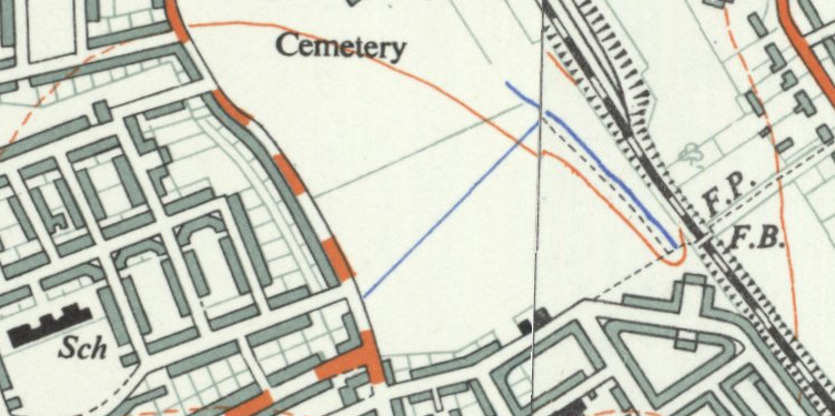
While fields in 1893, this area is now part of Hither Green Cemetery. It originally opened as Lee Cemetery in 1873 but with a much smaller size at the northern end of the current one. Like the Borough of Deptford cemetery we passed through in Grove Park, it was outside the jurisdiction it served, all on the Lewisham side of Hither Green Ditch. There are two impressive chapels, the Dissenters one (for Methodists and the the Baptists of Lee High Road and what is now Baring Road), was built by William Webster of Blackheath and was damaged during the last war and is slowly decaying.

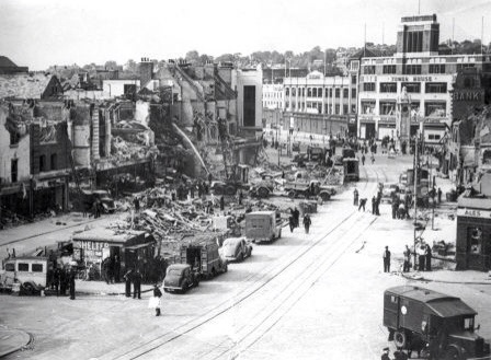
The southerly end of what is now the cemetery had changed from farm land to allotments in the early part of the 20th century. The exact timing of the expansion of the cemetery into the allotments isn’t clear, it was probably just before or just after the start of World War 2, it was showing as allotments in the 1938 surveyed Ordnance Survey map. But by the time the children who died in the awful attack on Sandhurst Road School in early 1943, were buried the area had expanded. There is a large memorial to those who perished, something covered in a blog post that marked the 75th anniversary of the bombing in 2018. The crematorium in the south east corner was opened in the 1950s.

The 1893 boundary is relatively easy to follow on the ground through the cemetery as Hither Green Ditch has left a small valley close to the Lombardy poplars that border the railway.

Just outside the cemetery in 1893 was a small hospital, Oak Cottage Hospital; it had been built in 1871 by the local Board of Works for dealing with infectious diseases like smallpox and typhoid (1).  It was overtaken by events in that the Metropolitan Board of Works (which covered all of London) decided to open a series of fever hospitals as a response to a major Scarlet Fever epidemic in 1892/93, the health system was unprepared and there was a severe shortage of beds.  One of these was the Park Fever Hospital, later referred to as Hither Green Hospital; Oak Cottage Hospital was briefly considered as a possible alternative location (2).   Oak Cottage Hospital closed soon after Park Fever opened in 1896 (3).  It eventually became housing in the 1960s or 1970s.

Beyond Oak Cottage Hospital in 1893, were again fields, probably part of Shroffold Farm. On the opposite side of Verdant Lane (then Hither Green Lane) was North Park Farm, about to be ploughed under by Cameron Corbett. The Lee Lewisham boundary continued to use Hither Green Ditch which was to remain visible until the development of the Verdant Lane estate in the 1930s. This section is pictured below, probably soon after the Corbett Estate was completed around 1910.

In addition to the Ditch, there were a pair of long gone boundary markers, one was just to the north of the junction of Verdant Lane and Sandhurst Road, perhaps at the point one of the confluence of two of the branches of the Ditch; the other where it crosses St Mildreds Road – again a possible branch of the Ditch that would have been obliterated by the railway.

St Mildreds Road hadn’t existed when the Ordnance Survey cartographers had first visited in the 1860s. While the church of St Mildreds had been built in 1872, even in 1893 only homes at the Burnt Ash Hill end had been build, including another of the homes in the area of E Nesbit in Birch Grove.

The boundary went under the railway close to what was a trio of farm workers cottages for North Park Farm, which are still there at the junction of Springbank Road and Hither Green Lane.

The boundary continued to follow Hither Green Ditch – it wasn’t just a Parish boundary at this point, but a farm boundary too – on the Lewisham side, Hither Green’s North Park Farm, which was mainly on the other side of the railway and was sold at around the time that the land was surveyed and would form the Corbett Estate. On the Lee side was Lee Manor Farm, which is pictured on a 1846 map below (right to left is south to north, rather than west to east) and Hither Green Ditch which had several small bridges is at the top.  There were several boundary stones and markers along what was broadly Milborough Crescent and Manor Lane.  There was then a sharp turn to the east along what is now Longhurst Road.

The confluence of Hither Green Ditch with the Quaggy was in a slightly different place in 1893, then it was more or less where 49 Longhurst Road is now located; it is now around 40 metres away on a sharp corner between between Manor Park and Longhurst Road, as pictured below.

We’ll leave the boundary of Lee and Lewisham here for now following what is now the Quaggy into Lewisham in the next instalment.

This series of posts would probably not have happened without Mike Horne, he was the go to person on London’s boundary markers, he had catalogued almost all of them in a series of documents. He was always helpful, enthusiastic and patient.  He died of a heart attack in March but would have loved my ‘find’ of a London County Council marker in some undergrowth on Blackheath, and would have patiently explained the details of several others he knew to me.  A sad loss, there is a lovely series of tributes to him.

Notes

  1. Godfrey Smith (1997) Hither Green, The Forgotten Hamlet p54
  2. Woolwich Gazette 02 June 1893
  3. Smith op cit p54

Picture Credits


The Bombing of Sandhurst Road School

Perhaps the most depressing and bleak of Lewisham’s World War Two memorials can be found in Hither Green Cemetery on Verdant Lane – it is to the 38 children and 6 teachers who perished in a daytime bombing of Sandhurst Road School on 20 January 1943.

The school between Minard and Ardgowan Roads had been opened in 1904 – midway through the development of the Corbett Estate – it was not that dissimilar to many of the era, including the one on Eltham’s equivalent Corbett Estate.  The opening ceremony was performed by the Chairman of the London County Council (LCC), J Williams Benn – grandfather of the late Labour politician Tony Benn. The LCC had just taken over responsibility for London’s Schools including those in Lewisham, from the London School Board.

Many children had been evacuated from London in September 1939 but as bombing became less frequent after the Blitz ended in May 1941, lots had returned to the capital.  It was to be another 18 months before V-1 flying bombs started hitting south London.  There were though a few sporadic attacks designed to terrorise the civilian population in the intervening period – often in retaliation for Allied bombing raids on German cities – these became more organised towards the end of 1943 with Operation Steinbock.

The facts as to what happened are quite simple; it was lunchtime at Sandhurst Road School on 20 January 1943.  A group of 28 Focke-Wulf 190 Fighter-Bombers, escorted by Messerschmitt Bf 109 fighters (totalling about 60 planes), had taken off at around noon in occupied northern France and had evaded air defences and one of them was able to fly low over Catford and Downham. One of the  Focke-Wulfs was seen over Downham Way spraying bullets towards those on the ground; soon after it flew over Ardogowan Road, just above the roofs of the Corbett Estate, it was carrying a single 500 kg bomb.

At just before 12:30 the plane flew over Sandhurst Road School, there were reports that the plane looped around the school with the pilot waving to children in the playground.  On the ground, the bell for lunch had just gone – a few children heard a distant air raid warning siren.  Some pupils made their way to the air raid shelter – oddly a bricked up classroom on the second floor.  The sound of the plane was heard and a few outside realised that it had black crosses of the Luftwaffe.

The bomb was dropped and the children in the air raid shelter were

transformed from neatly dressed school girls into ghastly frightening creatures, covered all over in dust which was choking us too and some of us bleeding from cuts …somehow, there was no panic — just bewilderment. Choking, bleeding and with tears streaming down our faces, we made our way out of the shelter, over girders, plaster, bricks, wood, glass ….. through the debris … there was a huge smouldering gap below us were the bodies of those children (who had been queuing up for lunch), some dead, some dying, some in terrible pain.

Initially even some of the children started to try to help with the rescue effort before emergency services arrived on the scene, but by the evening

it seemed that every available man in the locality was there, digging, some with their bare hands, as was my brother, frantically searching for loved ones, hearts and hands torn. Boys in the services home on leave, digging, searching, all through the night. The Red Cross, the women in the church hall just across the road making tea, tending those brought into the hut, even the vicar in his shirt sleeves had been there since the search had begun. All with one motive, even if it meant constant danger from falling rubble — to get those little mites out.

Sandhurst School1

© IWM. Original Source– Non-commercial reproduction allowed

Despite the claims of the pilot waving at children there is some debate as to whether the pilot realised that it was a school – his report on the raid noted that the large building destroyed was block of flats.  However, other local schools though seem to have been attacked by machine gun in the raid, not necessarily by the same plane though, including at the nearby Catford Boys School and at Prendergast (then on Rushey Green) and a little further away on Ilderton Road, off the Old Kent Road.

Sandhurst School 2

Source News Shopper

In addition to the attack on Sandhurst Road School and the indiscriminate machine-gunning of civilians, which killed six and injured fourteen, there were several other local bombings in the same raid – the recorded ones are serious damage to several houses in Woodlands Street, off Hither Green Lane; Woodham’s Yard on Sangley Road (covered in happier times in Running Past in 2017) took a direct hit with six perishing and 14 injured; and four houses were demolished in Glenfarg Road (1).

Most of the victims, 31 children and one of the teachers, Harriet Langdon, were buried together at Hither Green Cemetery in a civilian war dead plot a week later after a memorial service at St Andrew’s Church on Torridon Road.   The photograph with the small coffins at the crowded cemetery from the Illustrated London News, below (2), is perhaps the most poignant one relating to the bombing, much more so than those of the destruction to the school.

Equally moving was a description within one of the press reports from the Daily Herald (3) of one brief encounter with a 14 year old at the cemetery

“Children walked past the grave – snowdrops narcissi, anemones drifted over the silver name plates.

A girl twitched my coat.  She said “Can you see Rodney’s names down there?  I’ve brought violets for him. They’re the first from the garden.

She was June Jarrett.

When the school at Lewisham was hit, she spent hours searching in the debris for Rodney, her six-year-old brother.

Now with violets in her hand she sought him again.”

Unsurprisingly, most of the victims lived relatively close by, within a mile and a half or so of the school; there were still some who lived some distance away – their parents perhaps moving after the child had been admitted to the school. As has been noted in other posts on World War 2 bomb and rocket damage, despite the war there was still a lot of movement between homes in an area where the private rented sector was large and security of tenure limited, but obviously too because of damage to homes in the Blitz.  The biggest concentration was around  South Park Crescent where 5 of the victims lived.

The orange ‘pin’ marks the school, blue pins children, purple the homes of two siblings and red, the homes of the teachers who died (one is off map in Surrey).  The data came from the CWGC website.

There don’t seem to be any equivalent daytime attacks on Berlin schools by the RAF, although attacks tended to be at night time to avoid the German air defences.  There were in total just over 67,000 British civilian deaths during the war – a figure dwarfed by the numbers of ordinary Germans who died – estimates vary from 1.5 to 3 million, including thousands in the Charlottenburg area that Lewisham is now twinned with.  But it seems that this Terrorangriff, terror-raid, may have been a reprisal, demanded by Hitler, for a RAF bombing of Berlin on 17 January 1943.

That so many bombers got through the air defences without adequate warning and allowing such a catastrophic loss of young life to occur seems like an abject failure.  The Air Minister’s explanation was it was initially thought that the raid was heading for the south coast and it was policy not to send warnings to London unless it was certain that the raid was heading that way. Otherwise the Germans could have easily sent Londoners scurrying into shelters every few hours by sending planes over Kent.  It appears that of the 60 planes, it was a smaller group of around 12 that peeled off towards London which was initially missed and as a result warnings were late (4).

The school was rebuilt after the war and remains – there is a memorial garden of remembrance to the victims and a stained glass window.

There are several contemporary videos that include footage showing the devastation of the school, including this one.

There are some memories of a survivors of the attack in a documentary made to mark the anniversary of the start on World War 2.

The bombing is still remembered in the local community. One of the 2022 Corbett Estate Advent Calendar windows around 50 metres away from where the bomb hit, depicted it; it was day 20, the day of the month of the bombing with an angel for each of those who died. It is also included in series of tiles between reception and nursery at the school – see bottom picture.

Finally, it is worth remembering the names of those who died at the school

The children

  • Malcolm Britton Alexander (11)
  • Brenda Jean Allford (5)
  • Lorina Elizabeth Allford (7)
  • Olive Hilda Asbury (12)
  • Joan Elizabeth Baker (12)
  • Betty Ellen Barley (15)
  • Dennis Handford Barnard (10)
  • Ronald Edward Barnard (9)
  • Anne Rosemary Biddle (5)
  • Judith Maud Biddle (5)
  • Kathleen Myrtle Brazier (13)
  • Donald Victor Brewer (10)
  • Joyce Agnes Brocklebank (11)
  • Pauline Feo Carpenter (4)
  • Margaret Kathleen Grace Chivrall (12)
  • Pamela Mary Joyce Cooper (15)
  • Winifred Mary Cornell (13)
  • Eunice Joan Davies (9)
  • Pauline Mary Davies (7)
  • Joan Margaret Day (12)
  • Olive Annie Margaret Deavin (15)
  • Anthony Drummond (9)
  • Janet Mary Dutnall (5)
  • Richard George Fagan (9)
  • Cyril Arthur Glennon (6)
  • Norman Frederick Greenstreet (8)
  • Norah Marie Harrison (9)
  • Sylvia May Ellen Head (12)
  • Iris May Hobbs (15)
  • Rodney Charles Ash Jarrett (6)
  • John Edward Jones (10)
  • Doreen Alice Lay (6)
  • Mary Rosina O’rourke (15)
  • Evelyn Joyce Scholes (11)
  • Pamela Eileen Silmon (10)
  • Clive Derek Tennant (8)
  • Doreen Thorne (12)
  • Edna Towers (12)

And the teachers

  • Ethel Jessie Betts (53)
  • Virginia Mary Carr (38)
  • Mary Frances Jukes (38)
  • Gladys Maud Knowelden (51)
  • Harriet Irene Langdon (40)
  • Constance May Taylor (58)

Notes

  1. Godfrey Smith (1997) Hither Green – The Forgotten Hamlet pp63-64
  2. Illustrated London News (London, England), Saturday, February 06, 1943; pg. 159; Issue 5416
  3. Daily Herald 28 January 1943
  4. Hull Daily Mail 27 January 1943

William Webster – A Victorian Building & Civil Engineering Contractor

One of the larger houses on Lee Terrace is Wyberton House, it was home to one of a major building and civil engineering contractors of late Victorian London, William Webster whose firm was one of the main ones used by Joseph Bazalgette.  He lived close to St Margaret’s Church, for the last couple of decades of his life.  Amongst the firm’s work were three of my favourite south east London buildings – all of which have some exquisite detail:

  • Crossness Pumping Station
  • Hither Green Cemetery’s Non-Conformist chapel
  • Blackheath Concert Halls

image

William Webster was born at Wyberton, a small village near Boston in Lincolnshire, probably in 1822 based on census and birth record data.  After an apprenticeship with a local builder, he set up his own business restoring churches – amongst his early work was restoring the partially 9th Century church of St Peter & St Paul, Algakirk (pictured below via Wikipedia Creative Commons) with the renowned architect, Sir George Gilbert Scott, work which was completed in 1851.

algarkirk_church_-_geograph-org-uk_-_2500


He gradually took on larger work further south, including asylums in Cambridgeshire and Hertfordshire in the latter part of the 1850s.  He moved to 1 Grove Place in Lee (now Belmont Grove) around 1860 – he, his wife, mother, three children and two servants were there in the 1861 census.

image

He won several contracts for projects led by Sir Joseph Bazalgette including several of the northern Thames Embankments to allow for the construction of the Circle Line and sewer system, and several sewage pumping stations – notably Crossness in Thamesmead.   Opened in 1865, the building is impressive from the outside, built in a Romanesque style, but once inside it becomes clear why it is often referred to as ‘Cathedral on the Marshes’  – it has magnificent cast iron work, that has been painstakingly restored and is well worth a visit.  Webster’s name is cast into some of this.

image


The Dissenters Chapel at Hither Green Cemetery dates from a decade later, opening in 1873, when it was referred to as Lee Cemetery.  The Gothic building has some stunning detail – including some wonderful gargoyles in the small spire.  It suffered from World War 2 bomb damage and has been boarded up and allowed to decay since.  Its neglect gives it a slightly eerie feel, and, perhaps, adds to its beauty.

image

The large amount of work that the firm was obtaining allowed Webster to build a home to match his, presumably very large income.  He bought two adjacent smaller houses, 7 and 9 Lee Terrace, part of what are sometimes referred to as the Lee Grove Group which he then demolished and replaced with the massive 15 bedroom Wyberton House which was completed in 1869.  An estate agent’s description is in a cutting below, but its listing text describes it as

Stone fronted with polished granite decorations, other sides stock brick. Slate roof concealed by parapet. Slightly irregular building of 3 storeys ; 7 windows. Panelled parapet.  Cornice of alternate paterae and brackets. End windows set back. End quoins. Windows have cambered architraves with keystones and stops. First floor windows have cornices and brackets and window over porch has pediment on brackets. Porch has granite columns, fretted balcony and 4 steps. Three-light canted bays either side, the right side window with glass removed for chapel use.

The wealth also allowed a large number of servants – this grew from  two in the 1861 census to six in the subsequent  three – it wasn’t a house where servants would get any long service awards though, none of them appeared in more than one set of enumerator records.

William Webster died in 1888 and was despite his building the dissenters’ chapel at Hither Green Cemetery, he was interred at St. Margaret’s, Lee just over the road from where he lived.

image

Oddly for what was such a large company, it seemed to have disappeared almost without a trace – it certainly traded after William’s death, seemingly taken over by his eldest son, also William, who was listed as a contractor in the 1891 census.  Blackheath Concert Halls built in 1896, was constructed his stewardship.  However, it seems that the firm was sold up or folded soon after – by the 1901 census William was listed as a ‘Scientist, Living on Own Means’  – William was to die during the next decade, probably in 1904.

image

As for Wyberton House – after William Webster’s (senior) death, several attempts were made to sell the property during 1890 but to no avail (1), and William (junior) was living there with his family when the census enumerators called in 1891. William moved on to slightly less grand surroundings, in 1901 he was at the now demolished 50 Lee Park (a few doors up from the bombed Christ Church) add link.  It seems that there were few takers for the mansion his father had built as it was often empty.

webster1

The House eventually found a long term use in 1906 when Knightsville College for Girls, moved from their previous home in what is now called Lewisham Way.  The College, run by Alton (or Altro) Knight had around 75 boarders in its previous location.  After the First Word War, the building was taken over by St Joseph’s Academy and it remained in their use until the early 1990s – amongst the pupils that would have passed through its doors were the author David Lodge, the sprinter John Regis and the footballer Jlloyd Samuel.  The house was converted into substantial flats after its use by St Joseph’s finished.

Notes

  1. The Times (London, England), Saturday, Jan 18, 1890; pg. 16; Issue 32912

Census and related information comes from Find My Past.


The Lewisham High Street V-1 Explosion

July 28th is the anniversary of the explosion of a V-1 flying bomb in Lewisham High Street in 1944, it landed on top of a street level air raid shelter outside Marks and Spencer’s but seriously damaged neighbouring shops including Woolworth’s and Sainsbury’s. It was 9:41 am on a busy Friday market day, so there was of little surprise that it was one of the worst single V-1 incidents with 51 deaths and 124 serious injuries in the shops, market and passing buses.

As would be the case now, those who died were from a relatively narrow radius – most had lived within 2 or 3 miles of Lewisham town centre. Frederick Bridges from Wisteria Road and Ethel Clark from Taunton Road both lived on roads I often pass.

There is a maroon plaque memorial at the site – still a Marks and Spencer shop – which was unveiled in 2011, and replaced an earlier footpath memorial which had become somewhat eroded.

20140728-091143-33103111.jpg
The victims are also remembered in a memorial at Hither Green Cemetery.

20140728-091334-33214276.jpg
The physical impact on the town centre was considerable too as the photograph on the Lewisham War Memorials wiki shows. There was damage for up to 600 metres from the site which led to the post war redevelopment of the town centre.

20140728-091423-33263684.jpg
The first V-1, that became known as doodlebugs, was launched at London on 13 June 1944 a week after the D Day landings. At its peak, more than one hundred V-1s a day were fired at south-east England from sites in Northern France decreasing in number as launch sites were overrun until October 1944, when the last V-1 site in range of Britain was captured, although there were a small number of later air launched attacks.

There were some attempts to use double agents to persuade the Germans that the V-1s were over-shooting their targets and landing to the north west of London, this may explain the reasons for the volume of V-1s that hit South London. The old boroughs of Croydon (171), Wandsworth (122), Lewisham (114) and Woolwich (77) were the 4 locations hit the most. The City of London and Westminster only received 17 and 29 attacks respectively.

Over 6,000 were killed in the V-1 attacks and 18,000 seriously injured. It is worth remembering though that there were much higher death levels of ordinary Germans in the Allied bombing campaigns. In Berlin, almost half of the city’s homes were destroyed, and a further third uninhabitable by the end of the war, with over 20,000 deaths. Lewisham is twinned with the Berlin suburb of Charlottenburg-Wilmersdorf, where a bombed church remains as a memorial – the Kaiser Wilhelm Memorial Church was still being being repaired in 2013 when photographed but now re-opened.

20140728-091526-33326622.jpg

Hither Green Ditch – A Tributary of the Quaggy

Hither Green Ditch or Hither Green Quaggy is a short tributary which flows, hidden, through parts of Downham, the borders of the Corbett Estate and Hither Green.  The nomenclature ‘Ditch’ is used quite a lot within the Quaggy catchment, it shouldn’t be seen as belittling of derogatory it is just the way smaller streams are described – there are Milk Street, Grove Park,  Border and Petts Wood further upstream.

Like the Quaggy itself, there are probably several sources to the stream.  There is certainly some evidence on a 1920s OS map of a thin blue line going back towards Grove Park across the railway.  Any evidence of contour lines that would have supported this as a source were obliterated with both the construction of the main line and the railway sidings. 20140718-184743-67663559.jpg

There is some support for an east of the railway source on the Environment Agency flood risk maps too.

HGD EA

To the west of the railway, there were ponds on Shroffold Farm  (now the location of a mosque at the junction of Verdant and Whitefoot Lanes and Northover, which Ken White  (1) had the source as – he is almost certainly right.  While the pond may have been fed by a small spring – there may also have been some run-off from the area around Whitefoot Lane, which is gently sloping down towards the former pond at this point. (See map below on a Creative Commons from the National Library of Scotland).

HGD 1

Another branch is clear too from the  tell-tell notches in contour lines of fluvial erosion on Ordnance Survey maps point further uphill, towards the top of the hill on the Downham Estate.  While the stream wasn’t marked on old Ordnance Survey maps – it may have been dry by then – its course is obvious on the ground with distinct dips on Tristram and Camlan Roads, similarly there is a depression where it would have crossed Northover at its junction with Durham Hill and Shroffold.  The north easterly course becomes slightly less distinct as land flattens out crossing Roundtable, Pendragon and Ballamore Roads.  There is a clearer depression in the north eastern end Reigate Road, where there is an attractive grassed square surrounded by houses.  These houses have problems with damp and there is local knowledge of an underground stream there (see comment from Brian below).

image

There is also a distinct dip Railway Children Walk (named after the Edith Nesbit book – Nesbit lived for a while in Tree Gables on the opposite side of the railway).  The ‘Ditch’ would them have continued into what is now the cemetery – although its current route would be blocked by a relatively recent mound of earth; the flood risk map (towards the top of the post) shows its likely route quite clearly too.  A 1961 OS Map shows both the branches still partially visible at that stage (on a Creative Commons from the National Library of Scotland).

HGD 2

Once in the cemetery there is a perceptible dip suggesting a course.  The cemetery has two distinct elements – initially the course is through the bleaker twentieth century part with more regimented lines of graves, fewer mature trees and with a partial backdrop of the railway sidings and yards.

20140718-185054-67854639.jpg

It has a slightly desolate feel to it when compared with the delightful, slightly overgrown Victorian northern quarter with a decaying dissenting chapel (built by William Webster, covered by Running Past in 2016) – partially destroyed by a World War 2 bomb.

20140718-184931-67771258.jpg

Before leaving the cemetery, a detour of a hundred metres or so to the south of the chapel is worth making to the memorial to the Sandhurst School disaster, where 38 children and six teachers died in a day time bombing in 1943, perhaps more on that another day.20140718-185239-67959997.jpg
At the north of the cemetery there is what looks like a ditch, while the was no evidence of any water it seems likely that this was its course as a local resident remembers a stream at this point (see comment from Dean). He also recalls it being piped to follow a course behind South Park Crescent and then towards Oak Cottages. This is certainly the route that contour lines would suggest.

The stream would have joined the now not particularly Verdant Lane just beyond Pasture Road – there is a clear dip in the road, adjacent to the Verdant Lane Community Wildlife Garden. There is no waterway to see, although there is a speedboat that has been ‘moored’ in a front garden for as long as I can remember.

20140718-184347-67427171.jpg

At around this point, close to the junction with Sandhurst Road, Hither Green Ditch would have been joined by another small stream, which can be traced through the Corbett Estate.  Going up stream, probably crossing Minard Road mid-way between Dowanhill and Hazelbank Roads and crossing Dowanhill Road around its junction with Broadfield Road – in quiet moments there is the sound of water beneath manhole covers at this point.  The contours are visible on the 1961 1:25,000 Ordnance Survey map below, (on a Creative Commons via the National Library of Scotland) with just perceptible dips in the roads. While I didn’t hear any sounds of subterranean water emerging from manhole covers – those who live there have heard them around these streets.

HGD 3

There is also evidence there of a water-filled ditch at the back of homes on Hazelbank Road and the Excalibur Estate, there is a thin-blue line on the 1961 map and seemed big enough for a swan to be able to use it (see comment from Diane on one of the posts on the Quaggy).  It seems to have had an issue behind 244 Bellingham Road and disappeared into a sink between 143 Hazelbank Road and 6 Wentland Close – see map below on Creative Commons via National Library of Scotland).  There are clear sounds of water rushing below the street from a couple of manhole covers at the northern end of Longhill Road, but the sounds peter out further south; it may be that the source is on the eastern side of Forster Memorial Park, but there isn’t any cartographical or on the ground evidence of it.

HGD 4

There seems to be a second source for the tributary – water below a pair of manhole covers can be clearly heard at the T junction of  Castillon Road and further north on Broadfield Road, close to the junction with Hazelbank Road.  Similar pairs of manhole covers and dips in roads can be seen on Gilton Road and on Waters Road, but, sadly given the street name no sound of water, nor was there any clear evidence  further south.

This tributary stream probably provided the water for South Park Farm, a small farm of around 70 acres centred around Dowanhill and Hazelbank Roads. After moving to somewhere around the Torridon and Brownhill Roads junction, the farm was renamed ‘Longmisery’ (2). It merged with North Park Farm (which we will ‘visit’ further downstream) in the mid-19th century.  Perhaps this small stream should be called South Park Ditch.

The main stream’s original course would have taken it across what is now the South Circular just to the west of the railway bridge before being bridged by the railway behind the junction of Springbank Road and Hither Green Lane. To the east of the railway it flowed through what are now the gardens of Milborough Crescent, just south of its junction with Newstead Road. The Crescent followed the long curve of the stream before it reached and was bridged by the railway on Manor Lane.  While it is not visible at this point, it is certainly still flowing – there was a serious diesel spillage in early 2016 in the yard which polluted Quaggy and lower reaches of the Ravensbourne.

The stream flowed alongside Manor Lane for another couple of hundred metres before turning west-north-west and meandering across the line of Longhurst Road, joining the Qauggy where it dog-legs to the north.  This is all now covered.

Around here the stream would have been joined by a small tributary that seems to have ‘risen’ just the other side of the railway on what was North Park Farm which was roughly in between where Duncrievie and Elthruda Roads are now. The sale of the 278 acre farm to Archibald Cameron Corbett in 1896 was to allow the development of the western side of the railway. Despite being a junction for around 30 years, Hither Green had only opened as a station in 1895. A new booking hall was built to the west of the station in Springbank Road as part of the development – its red brick gateposts are still visible as the entrance to a new housing association development. The original stationmaster’s house survives, adjacent to the gates, at 69 Springbank Road.

20140718-185407-68047305.jpg
The tributary flows through the nature reserve of Hither Green Triangle between platforms 4 and 5 of the station; this offers the only above ground remnants of the tributary or indeed the main stream. From the far end of platform 5, the stream is just visible, way below the platform level – not surprisingly given the viaduct the railway is on. The water was glistening in the sunlight when I visited. While access to the nature reserve is rightly limited, its management plan, while confirming the stream’s presence gets its direction of flow wrong (although the original mistake seems to lie with the now defunct London Ecology Unit).

‘A small stream trickles from north to south across the east of the site’

20140718-185534-68134763.jpg
The tributary would have originally emerged from the embankment from platform 6 somewhere between the house and the bus stop before trickling on towards Longhurst Road.

20140718-185800-68280126.jpg
The final outflow of the substantive stream into the Quaggy would have been around where it is bridged by Fernbrook Road, although nothing is obviously emerging from the brickwork ‘bank’, presumably long since culverted away.

Notes

  1. Ken White (1999) “The Quaggy & Its Catchment Area”
  2. Godfrey Smith (1997) ‘Hither Green: The Forgotten Hamlet’ p12