Prior to the arrival of the railways, Hither Green and Lee were rural, a mixture of farming – such as Lee Manor Farm to the east and North Park Farm to the west of what is now Hither Green Station and the large country houses of Lee including the Manor House and The Firs. The railways directly and indirectly brought lots of new inhabitants, although the distances travelled and the modes of transport changed considerably in the 20th and 21st centuries.
Running Past has touched on Victorian migration before in numerous posts, notably those around shopping parades – such as 1 to 19 Burnt Ash Road, where the family histories of the shopkeepers have been explored. However, in the first of what will be a series of posts, we look at Victorian migration through several streets starting with what was a working class street then called Robertson Street, now Brightfield Road.
It is a street that we have looked at before in a couple of posts on its history – the period when it was Robertson Street and after it changed its name in the late 1880s. It was one of the earlier developments of smaller houses in the area, built around 1862 by the builder and developer John Pound. Its purpose seems to have been to house workers that Pound needed to build larger homes along what was then Burnt Ash Lane (now Road and Hill) towards Grove Park.
By 1881 it was an established community – as we saw in the earlier post, male employment still focused on the building industry, the women of the street were generally working too – mainly employed in washing, ironing and cleaning for the middle classes of the wealthier streets.
So where had these people come from? Census records for 21 houses, then numbered 30 – 50, have been looked at in terms of birthplaces. There were 33 households in those houses with 72 adults and 54 children. We’ll look at the adults first.
Given that the area had been developing since the early 1850s and the street since 1862, it is slightly surprising how few of the Robertson Street adults had been born in Lee, only 6 (8%), with the same number hailing from either neighbouring Lewisham or Blackheath.
21% came from established communities along the Thames from Chelsea to Woolwich via Deptford. Another half dozen (8%) from the rest of what was then London – so, in total, only just under a half were Londoners by birth.
Much of the migration though was relatively local – almost 1 in 5 (19%) came from the rural communities of Kent and Surrey, including many towns and villages now subsumed into London such as Eltham, Bromley and Chislehurst – all were separate in 1881.
The equal biggest group (21%) came from East Anglia – almost all from rural communities, many from hamlets which have now almost disappeared. They are plotted on the map below.
The rest came from either the Home Counties (4%) or from a variety of other locations around southern England plus one from Wales and one who was off map who was born in an unknown location in Scotland.
Their children were very different though – of the 54, 40 had been born in Lee and, of the rest, all but three were Londoners.
One of the longer distances travelled were by a couple from North Norfolk, the Harpers. Charles Harper was a bricklayer at number 42 who came from Roydon near Kings Lynn around 110 miles from Lee. Born in 1846 he was still in Roydon in 1861, aged 14, working as a bricklayer, probably with his father who was in the same trade. A decade later he was married to Elizabeth, who was from nearby Hunstanton in Norfolk. They had moved to London and were living at 18 Summerfield Street in Lee with Charles still working as a bricklayer, the street is pictured below. Like the houses in Robertson Street, they were built and rented out by John Pound many housing the labour for his building firm.
The family was still in Lee in 1891 – living at 7 Manor Lane, possibly working for WJ Scudamore, whose base was a couple of doors away (pictured below from 2015). Beyond 1891 the trail goes cold on them though. Like most of their neighbours in Robertson Street, all of their six children were born in Lee.
A later post will look at migration to one of the wealthier streets of Victorian Lee, probably Handen Road, to see whether the patterns of migration are different there.
Credits
Census and related data comes via Find My Past, subscription required
The maps have been created via Google Maps using 1881 census data
A while ago Running Past looked at Northbrook Cricket club who had a ground In an area bounded by Manor Lane, the railway from Hither Green, Burnt Ash Hill and Holme Lacey Road. They had cricketing next door neighbours – Granville, whose ground had some illustrious visitors and parts of whose story we will look at now.
Unlike Northbrook, the club wasn’t formed in Lee, it had been in existence in Blackheath for 18 years before it arrived in Lee in 1884, a decade after its neighbours. Like Northbrook, it was a name that related to local landowners. The name Granville appears in several street names including on the northeastern side of Lewisham High Street, Granville Park and the lost Granville Mews – the ‘ghost’ of its name superimposed over the lovely Holdaway ghost sign on Belmont Hill.
Long and Lazy Lewisham blog noted the derivation earlier in the year – it was a family middle name used by the Eliot family who were the Earls of St Germans. It would have been the 3rd Earl of St Germans, Edward Granville Eliot, who the parish would have been referring to when naming the streets.
The club appears to have been set up by Pearse Morrison (1) a commercial stationer and printer, who lived in Blackheath at a house on one of those streets named after the Earls of St Germans – 5 Eliot Park (2).
They played on the Heath (3), the freeholders for which were the Legge family, later the Earls of Dartmouth; there were 18 adult cricket pitches on the Heath in 1890 and no doubt a similar number a few years before (4). However, there was no booking system for pitches with a “first there has the ground” rule (5), so for a club with seemingly wealthy members it may have encouraged them to look elsewhere.
The moved to Lee was for the 1884 season, that campaign was good one – they played 23 won 11, lost 2, drew 10 (6).
A prominent name in the club around the time of the move to Lee was ‘Furze’ who lived at The Laurels, also known as Laurel Cottage, a large house on Hither Green Lane from the mid to late 1860s until the early 1880s. It was initially home to wine merchant Thomas Holloway Furze who died in 1869, and his wife Emma who died in 1882. At least three of their sons played for the club (7).
Frederic, born in 1852, who was the club Vice President in 1878 (8). He moved to Copers Cope Road in Beckenham by 1881, along with his brother Edwin, it seems that they took over his father’s wine business.
Herbert Furze (1856), unlike his brothers, became a stationer and after living at The Laurels in 1881, he had married and moved to Foots Cray by 1891.
Edwin (1858) was also living at the The Laurels in 1881, but moved closer to the ground and in 1891 was at 56 Handen Road. Edwin was still playing at that point and in pictured in the 1893 team photo, which we’ll cover later.
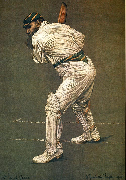
During the 1890s a well known name played in several matches against Granville – Sir Arthur Conan Doyle who played for Norwood. Conan Doyle was a decent cricketer and played several First Class matches for the MCC, just down the road from 221B Baker Street. His cricketing claim to fame was getting perhaps the biggest wicket of all, W G Grace.
The game’s afoot …..Conan Doyle’s first match in Lee was in 1891, when C J M Godfrey ripped through the Norwood batting taking five wickets, more on Godfrey later. Doyle fell cheaply, stumped off W Edwards bowling, taking no wickets himself. Like all the other batsmen he struggled on a rain sodden pitch in Norwood in a drawn game in September 1892. In July 1894 a Conan Doyle 38 saved the Norwood from defeat in Second XI match in Lee.
Later the same season, he opened the batting for the 1st XI in a fixture at Norwood’s Pavillon Grounds, getting 20 before Helder bowled him, one of 8 wickets taken by him. Whilst Doyle picked up a wicket it wasn’t enough to prevent a heavy defeat to Granville.
A Granville team photograph survives for the 1893 season. Many of the names are ‘lost’ in terms of who they were but a few are worth mentioning. Charles John Melville (C J M) Godfrey was a professional who the club employed. He was a right-handed batsman and a right-arm fast bowler who played a handful of first class matches for Sussex between 1885 and 1892 with a career best bowling of 5 for 22 in 1890, and a best of 17 with the bat in his final match against Yorkshire in 1892. Whilst playing for Oxford University his bowling was described as ‘energetic, if erratic’.
Perch (bottom row) was the grounds man (9) – it isn’t clear whether the lack of initial related to this status. Edwin Furze (next to bottom row) we’ve already covered above. George Helder, who we’d seen above taking the wicket of Sir Arthur Conan Doyle, was the son of the Vicar of St Mildred’s church, a few hundred metres from the ground – he was 17 in 1893.
Philip P Lincoln lived at a house almost opposite St Mildred’s church and was a Lime and Cement merchant. He seems to have continued his involvement in the club until the outbreak of World War 1. Hope was expressed that he would be able to keep the club going after the loss of the ground (10).
R A (Richard Alfred) Glover, the bearded man in the centre of the picture, was the owner of the Wenlock Brewery in Hoxton, who lived at 143 Burnt Ash Road. He was presumably an officer of the club and will have made sure that the bar was well supplied. He’d moved onto Croydon by the time of his death in 1898.
During the 1893 season their primary matches were against Bickley Park, Croydon, Crystal Palace, Hampstead, Tunbridge Wells, Charlton Park, Streatham, Forest Hill, Hornsey, Blackheath, Bradfield Waifs, and a benefit against MCC and Ground (11) the ‘MCC’ were the amateurs who were members, the ‘Ground’ the professionals. There was no league structure and the games were virtually all friendlies.
1893 saw the tradition of an August tour of Sussex continue with a week of matches in Eastbourne, St Leonards and Willingdon (12).
There was also a home Granville Cricket Week in early August – the 1893 edition included games against Old Chigwellians, Border Regiment, Stoics, Eltham and a defeat to Forest Hill (13).
Fast forward into the new century a name appeared in the Granville scorecards that will be familiar to most people – W G Grace. Running Past covered his later years in south London a while ago. The last club he played for was Eltham and his first match for them was against Granville on 28 May 1910, at Chapel Farm (the current site of Coldharbour Leisure Centre). His impact was limited, while he opened the batting for Eltham he was trapped leg before wicket for 3 (14). An excellent scalp for an unnamed Granville bowler – likely to be either A S Johnson or J A Rutter who seem to have opened the bowling much of that season.
As well as turning out for Eltham, Grace still played for the MCC and captained them in their regular appearance at the Granville Cricket Week in 1912. Granville were made to bat and skittled out for 63; the MCC after an early wobble comfortably surpassed the home team’s score. E L Downey took 5-36 for Granville. In the other fixtures at Lee that week, they lost a thrilling final match to Guys Hospital by 2 runs despite a good opening partnership between J O Anderson and N Cockell. Earlier in the week Anderson had put together a team which Granville had beaten. They had also lost heavily to a Hampstead team that contained Harold Baumgartner who played Test Cricket for South Africa – his slow left-arm spin on a drying pitch had bewildered the Granville batsman – taking 9 wickets very cheaply, eight of them bowled (15).
Grace appeared again in Lee for the MCC in 1913, they heavily defeated the men from Granville scoring well over 300 before dismissing the home team for less than 100, Grace’s contribution is not known. In the Granville Cricket Week that year there were three victories for the home team – against Forest Hill, Hampstead and J Anderson’s XI, with defeats Wanderers, Richmond as well as the MCC. In games against J Anderson’s XI and Hampstead (and possibly others) there was a significant name playing for Granville, Cyril ‘Snuffy’ Brown who scored a century and took 9 wickets in the first of these (16).
Brown was a West Indian Test cricketer described as ‘a devastating bowler and attacking batsman’ who was a pioneer of bowling the ‘googly.’ He had already played for Barbados and the West Indies against the MCC when he came to London to train as a barrister in 1911. He mainly played for Clapham Rovers but in an era where clubs only played friendlies he turned out for several others, including Granville. It wasn’t just his bowling that impressed – he was described as ‘a brilliant field(er), and a splendid batsman; he has an easy style and can pull a ball with remarkable ease’ (17).
He returned to the West Indies in 1914, going on to be the first black captain of an island team, and had it not been for the racism within West Indies cricket may well have gone on to captain the Test team.
An article in the Sporting Life in 1913 noted that the end was nigh for the ground, with development planned for after the 1914 season. World War One brought cricket to a halt there most sport – as we saw with Catford Southend. Cricket doesn’t seem to have restarted in Lee after the war (18).
The housing took a while to arrive – Holme Lacey Road was built by W J Scudamore in the early 1920s. The pavilion whose steps, W G Grace, and Snuffy Browne walked down is now occupied by 53 and 55 (pictured).
The Granville ‘square’ where Sir Arthur Conan Doyle will have taken guard was covered by the Chiltonian Biscuit factory which had moved on from Staplehurst Road. Today, it is the home of the Chiltonian Industrial Estate, pictured below, the square would have been at the far end of the photograph.
Notes
12 October 1878 – Kentish Mercury
20 July 1877 – Kent & Sussex Courier
19 June 1913 – Sporting Life Re Heath
Neil Rhind (1987) The Heath pp 55-56
ibid
26 September 1884 – Kentish Mercury
12 October 1878 – Kentish Mercury
ibid
21 September 1893 – Cricket
19 June 1913 – Sporting Life
13 April 1893 – Cricket
19 April 1893 – Sporting Life
10 August 1893 – Sporting Life
02 June 1910 -Cricket
19 June 1912 – The Sportsman
19 June 1913 – Sporting Life
07 September 1912 – Illustrated Sporting and Dramatic News
19 June 1913 – Sporting Life
Picture and Other Credits
The drawing of Sir Arthur Conan Doyle is via the Illustrated London News on 25 May 1901
The photograph of Snuffy Brown is via the Illustrated Sporting and Dramatic News 07 September 1912
The picture of W G Grace is from a year or two before he played for Eltham, as it is in the colours of London County, it is on a Wikimedia Creative Commons
Census and related data comes via Find My Past, subscription required
The 1893 team photograph & the picture of the Chiltonian Biscuit Factory are part of the collection of Lewisham Archives, they are used with their permission but remains their copyright
The map showing the location of the ground is on a non-commercial licence via the National Library of Scotland
In the first part of this post we looked at the early Victorian origins of the parade as it evolved from houses into shops. We’d seen gradual changes in the businesses reflecting Lee’s transformation from village to suburbia in the second half of the century. As we left it, it was a parade that seemed to be doing well – many of the shopkeepers able to afford to live in the suburban houses with servants.
We return to the parade as the new century dawned, again looking at each shop until redevelopment happened in the 1960s.
183 Lee High Road
183 was the shop next door to the Woodman; at the end of Victoria’s reign it was an Oil and Colourman, a paint seller, run by Frank Attfield. Frank Attfield’s name was to remain over the window until the late 1920s. Frank had retired by 1911 and the business was being run by his son, William, born in 1881. Both were living at 247 Lee High Road a house that was close to the corner of Lee Park – they had lived there since 1901. It is visible from Frank’s era in the postcard below.
Frank died in in 1938, he was buried at Hither Green Cemetery. At the time he was living at 14 Southbrook Road and left an estate of £15072 to William and his brother Edwin. It was a house he bought a couple of decades before.
William’s name stayed over the window until around 1950, when he would have been 69. However, other than his marriage to Dorothy in 1919, the trail goes cold on him.
Electrical Contractor Sidney Folkard was briefly there in the early 1960s, but the shop seems to have been empty after that.
185 Lee High Road
We’d left 185 with the name John Henry Churcher over the window of a carving and gilding business – essentially a picture framer. Living above the shop in 1901 though were Frederick Morse from Camberwell (41), his wife Marian and 7 children, the oldest (15) was also Frederick and worked the business too. Presumably Morse was Churcher’s manager as his name was above the window by 1911, with Churcher trading in Lewisham High Street by then.
The shop was empty in 1920. It had become a confectioner by 1925, known as Cox and Son – a trade that it continued in for most of the rest of the life. By 1939 Kathleen Latter lived there with husband Arthur who was a clerk elsewhere. She had gone before the end of the war – like a lot of confectioners seeming to struggle due to rationing. A series of names were over the window post World War Two – James Day in the 1950s, George Moiler by 1960, and J Atkinson in the 1960s. After that only Glenview Driving School got a mention in the depleted Kelly’s Directories.
187 Lee High Road
187 was a shop that stayed in the same trade, a butchers, throughout its history. Thomas Spearing straddled the turning of the centuries. He had been born in Redhill, Surrey in 1875, but he only lasted until few years into the new century before moving to south west London. In 1911 James Plummer (33) from Croydon was there; he had probably moved there by 1907 as all four of his young children were born in Lee.
Following James Plummer were Joseph Moore and Ernest Knifton, but they only lasted a few years each. Frederick Roy Nicholls was there by the time war broke out with wife Lilian assisting in the shop. Frederick died in 1962, when he was 66, and was probably running the shop until his death. Nothing obvious replaced the business.
189 Lee High Road
We’d left 189 with the name Harry Willson and Co, tailors, over the window. The Wilsons had moved on by 1900 and there was a new trade – a boot and shoe dealer run by Louis George Brunning. This was an expansion from the final shop in the parade at the corner of Lee Church Street, 205, where they ran an outfitters. We will cover the Brunnings there. J H Dodd took over the boot and shoe shop by 1911, although they were gone by the time World War 1 broke out and the shop was closed until the early 1920s.
There was a new trade by 1925, Pianoforte maker, which seems to have sold classical records too (1). The business was run by William Salisbury who had been carrying out the same business from 191 for at least a decade. Salisbury was born in 1868 and seems to have stayed at 189 until his death in 1942. Three years before he was there with wife Ethel, born in 1885; also there in 1939 was their son, also William (25); who was listed as ‘student, seeking work’ and Kate Bunyan who assisted in the shop. Kate was Ethel’s sister and later married James Salisbury who was presumably her nephew. The business continued until the end of the war, but the shop was empty in 1950 and remained so, seemingly for the rest of the building’s life.
191 Lee High Road
By the beginning of the century, Robert Oates’ drapers had expanded into the shop, that business is covered at 193, but pictured above, 191 is at the very left of the postcard.
The shop was empty in 1911 as Robert Oates sold up and the incoming draper, A Seymour, went back to two shops, which we’ll cover below. In 1915 a piano maker moved in, William Salisbury, it is a name that have already been covered – William spent most of their time on the parade next door at 189. The musical chairs of shop leases continued, no doubt accompanied by William Salisbury at the piano. Seymour’s took over 191 again when Salisbury moved next door – we’ll cover them at 193.
When Seymour sold up in the 1930s, 191 but not the rest of their mini empire, was taken over by the builder and plumber Benjamin Chapman who has been born in 1895. In 1939 he lived there with his wife Lilian and two others, whose entries were redacted – maybe young children who hadn’t been evacuated. The Chapmans had moved on before the end of the war and the shop was empty in 1945. Model Aircraft dealers, Prendergast and Co, took up residence for the sale of Airfix by 1950 and remained there into the 1970s.
193 & 195 Lee High Road
The drapers of Robert Oates had been a feature of this part of Lee High Road since 1881, like many well to do shopkeepers they had ceased living over the shop and had moved to 239 Lee High Road – a house that was between Lee Park and Dacre Park (then Turner Road). They had expanded into 191 and in the 1901 census 191-195 was home to Sarah Gilham and Blanche Wallis who worked in the shop, plus three servants – presumably for the family home.
In 1910, Oates seems to have sold the lease up to Edwin Seymour (also referred to by his middle name Augustus); Oates remained in the area until his death in 1921. Oddly, Oates didn’t sell the stock to Seymour – that was bought up by Chiesmans in Lewisham for a very precise 43.875% off list price by tender, presumably Seymour had offered less and was offered for sale in their Lewisham town centre shop in April (2).
Seymour would have been in his last 20s when he took over the business – he initially contracted a little, focussing the business on 193 and 195 with 191 being empty in 1911.
Seymour came from Spalding in Lincolnshire and in 1911 he was living over the shops with his wife Ellen; her parents; a servant, Rose Hardey, Carrie Simmonds who worked in the shop, and the Seymour’s young son Jack, born in Lee in 1908.
The Seymours’ business had expanded back into 191 by 1925. Seymour’s father, also Edwin Augustus, was living over the shop when he died in 1932. Perhaps soon after they moved home although not the business, as by the time the 1939 Register was compiled they were living at 21 Manor Lane, with a draper’s assistant. However, it seems that the shop wasn’t to last much longer when the 1940 Kelly’s Directory was compiled the shop was empty – maybe an early victim of rationing. It remained empty until the late 1940s when Builders Merchants William Ashby and Son moved in, taking on 193-201. They had gone by 1960 and seem to have been the last tenants.
197 & 199 Lee High Road
Charles Hopwood was running a long standing ironmongers at the beginning of the 1900s, although he seems to have extended his business and in the 1901 census was listed as a Sports Good Manufacturer living in Brandram Road. He seems to have moved to 61 Eltham Road – now part of the Ravens Way estate and opposite Leybridge Court – but died just before the census of 1911.
Presumably the new business was why he sold up as by 1905 there was a new name at 197 & 199, but same business – Percy Winkworth’s name was over the window of the iornmongers; it wasn’t a name to last long – the shop was trading as Lee General and Furnishing, still basically an ironmonger a couple of years later but by 1916 it was empty. It is pictured above from the corner of Bankwell Road (built 1907) next to development which included the short lived cinema Lee Picture Palace, which opened in 1910.
By the mid-1920s there was a timber merchant, trading as Woodworkers Supply Company which lasted into World War 2, but empty again by the end of it.
During the 1950s, it was used by the sprawling empire of William Ashby’s Builders Merchants. However, that was closed by 1960 and 197 was home to Vanguard Engineering, although that had gone by 1965. For a while, the business premises were shared with the printers Dickson and Scudamore. The Scudamore was George who was the younger son of Cornelius Scudamore, who was the architect for the large-scale local builder, W J Scudamore. The Dickson was George’s brother in law, Maxwell.
201 Lee High Road
William Button had been selling sweets to the people of Lee since around 1894 though, born in Greenwich around 1853 he was there with his wife Sarah and three daughters when the 1901 census was collected.
Button was replaced by John Moors by 1911, although he was not listing as living over the shop (or seemingly anywhere else for that matter). The name remained over the window until the 1930s – although by the outbreak of the war he seems to have been listed as a Snack Bar Manager living in Forest Hill. Maybe the parade couldn’t cope with two confectioners after Cox and Son opened at 185 in the mid-1920s.
In the mid 1930s someone called Newson was running the shop as a greengrocers – but was seeking offers in the region of £150 for the business, noting an annual rent of £70 (3).
By 1939 James Moulden was selling fruit– it wasn’t a business that lasted long as by the time the war ended, it was part of Ainslie and Sons based at 199. Like 199 it became part of William Ashby’s Builders Merchants, but when that closed in the 1950s, it seems to have remained empty thereafter.
205 Lee High Road
We had left 205 in 1901 when it was being run as an outfitter by Louis Brunning, he’d been there from the 1880s. By 1911 Louis had retired and was living in Bromley; his name still appeared over the shop window but it was his sons Herbert Welford and Leonard Godfrey Brunning who were running the business. Louis died in 1927, but by 1925 the brothers’ names appeared. Leonard died in 1934 and his name disappeared in subsequent Kelly’s Directories soon after.
The business seems to have remained in the family until Herbert’s death in 1956. The shop was empty in 1960.
Lee Service Station and Costcutter
It was clear that the parade had been on the decline since the end of World War One something probably exacerbated by the shiny new shops of Market Parade opposite which had opened in the 1930s.
Kelly’s Directories listed very few of the shops from around 1965, in a way that wasn’t the case with the parades on the south of Lee High Road, notably Market Parade opposite. This was probably because the shops were not let – perhaps beyond their useful life; requirements to pay to go into Kelly’s didn’t happen until the 1980s. The exceptions were J Atkinson, the confectioners at 185 and Prendergast & Co., Model Aircraft Dealers at 191 that lasted until around 1970.
By this stage the eastern end of the parade had presumably been demolished – it was listed as Carris Service Station from 1965, perhaps trading a year or two earlier. Carris Motors had been around for a while, there were several members of the Pilmore Bedford family who owned and ran the firm listed as running motor trade businesses in the 1939 Register, including a couple in adjacent houses in Bromley Road. The company Carris Motors was first registered in 1946. By 1953 they were based at Lewisham Bridge, where the DLR station is now situated, selling cars and light commercial vehicles as well as servicing and repairs. They seem to have sold Hillman, Humber and Sunbeam at that stage, all part of the Rootes Group.
The operation in Lee High Road is listed in Kelly’s ‘Carris Service Stations Ltd. – Motor Garage & Service Station.’ So it isn’t clear which elements of the business it included, but probably not sales. That moved on to Bromley Road in the 1960s, initially with the same Rootes brands, but by the late 1980s it had becomea Vauxhall dealership, then in competition with Lee Green’s Penfolds. They seem to have made the mistake of switching to the post British Leyland Rover by 1995 and had ceased trading by 1999.
By 1970 it seems that either Carris had sold up or it had been re-badged as Lee Filling Station. While it is has gone through various incarnations in terms of names it has been a BP garage for most of that time, surviving in a market that the supermarkets have muscled into. During the 1990s it expanded its range of goods initially selling newspapers and related goods and then becoming a Marks and Spencer food franchise, the current buildings being constructed in the early 2000s. Ironically, as we saw in relation to Market Terrace whose completion had caused problems for the older shops on the north of Lee High Road, itself suffered from the Marks and Spencer franchise.
At the other end of the former parade, 183-185, next to the Woodman is a block that received planning permission in 1993, but completed in 1999. Since then it has always been a Costcutter Supermarket. It has three stories of flats above it – significantly higher than the shops that preceded it but similar to the adjacent former Woodman.
Notes
Norwood News 16 December 1927
Kentish Mercury 22 April 1910
Sheffield Independent 10 March 1936
Credits
The postcard of the parade showing Oates drapers is from the authors own ‘collection’
Kelly’s Directories are via the always helpful Lewisham and Southwark Archives
Census and related data is via Find My Past (subscription required)
The postcard of the Woodman is via eBay in October 2016
The postcard from the corner of Bankwell Road is courtesy of Luke Anthony Briscoe on Facebook
Woodlands Street is a Hither Green road that has been touched on a couple of times before – notably in relation to its builders, WJ Scudamore who completed work on this and the neighbouring streets of Benin and Blashford at the end of the 19th century. This post looks at what was there before the the street was developed, Hope Cottage, the early residents along with the impact of the war on the street along with recent changes.
Hope Cottage was built on farmland in around 1840; it was described initially as Wood Cottage in the 1841 census. While it was called a ‘cottage’ it was anything but and was located on what is now the forecourt of the shops of 272/274 Hither Green Lane (1). Unlike many of the large houses in Hither Green and Lee, there was no complicated history of ownership and tenants to unravel, Hope Cottage was built for, and inhabited by, the same family throughout its life. The Ordnance Survey cartographers got to name wrong when they surveyed the area in the mid-1860s – describeing it as Oak Cottage. The real Oak Cottage was further south off what is now Verdant Lane.
It was built for William and Eleanor Butler (both born around 1785), the former was a wealthy grocer and property owner who hailed from St Pancras. It was an area they seem to have stayed in as all the children were born there.
In the 1861 census, what was then referred to as Hope Cottage was described as being in ‘Brightside’ – a lane down the side of the property to a property of that name, it is a name which lives on in the relatively nearby Brightside Road. Hope Cottage was home to the now retired Butlers, William and Eleanor along with their adult children Charles (42, born in 1819) and William (56, 1805) who were both fund holders and Eleanor (45, 1816) who didn’t work.
Eleanor (Snr) probably died in 1870; but everyone else had remained at Hope Cottage, with Richard, born in 1819 having moved back to the house. William (Snr) died in 1876. By 1881, all the younger Butlers were still there and had been joined by their younger sister Elizabeth who was widowed, all were described as having an income derived from houses and dividends.
By 1891 there was just Charles, Eleanor and Elizabeth remaining, all described as ‘living on their own means.’ In the latter years of the three siblings, the city was rapidly encroaching on what had been originally a country house:
By this stage Charles was the only remaining Butler, Elizabeth had died in 1893 and Eleanor in 1896. Charles sold up to W J Scudamore soon after Eleanor’s death and seems to have moved in with a nephew in one of the large houses on Brownhill Road – he was there in the 1901 census.
This was one of the earlier sites in the area that family building firm W J Scudamore developed in the area; the work was started in the late 1890s with payments for the connection of the sewers into Hither Green Lane made in 1899. However, the building was probably over several years. In the 1901 Census, 21 – 27 at the south western end (away from Hither Green Lane) were not recorded, with 19 and 20 (the numbering is consecutive) appeared not to be fully occupied and may have only just been let.
Unlike some of the bigger houses on Hither Green Lane along with the bigger Corbett Estate houses, Woodlands Street was a working class street. Virtually all the houses were subdivided into flats, 3 room flats 6/- (30p) a week with the 4 room variants 7/6d (38p) in 1904 (2) with the homes managed from the Scudamore’s estate office at 1 Benin Street. It was only the southern side of the street that was built on – the edge of the Park Fever Hospital formed the northern side of the street.
A few houses seemed have singles families, including the Ives at 2 and the Lees at 6, although with each of these it may be that part of the house was empty at the time the enumerators called in 1901. Some were significantly overcrowded – there were 14 people living at number 4. That said there were slightly fewer people living there on average than in the smaller houses in Ardmere Road in 1901 – the average there was 7.4 per house, with 6.9 in Woodlands Street with a median (mid-point) of 8 and 7 respectively.
The trades were all manual work, a lot linked to the building industry – it will be remembered that the Corbett Estate was still being built and while the Archibald Cameron Corbett used some of the smaller houses in streets such as Sandhurst Road to house workers, the demand for housing will have spilled out into estates such as this. Some of the tenants may also have been employees of the Scudamores. There were several bricklayers, a pair of plumbers, a house painter and a trio of carpenters. Several worked on the railway, perhaps based at Hither Green.
In the early years there were a few cases of crime – several of these involved neighbour disputes and included one of tenants of 24 being convicted for throwing a flower pot at child of the other tenant of 24, while it missed, the court fined her 5/- (25p) (3).
There were a fair number of cases of drunkenness; George Fowler of 10 was convicted of being drunk and disorderly, using abusive language towards the police and fined £1 or 2 weeks in prison (4). His neighbour at 11, Andrew Smith, was arrested for being drunk and disorderly at the Black Horse in Catford in 1905 and was fined as a result (5).
Richard Sancto of no 7 was charged with being drunk and disorderly and assaulting Joesph Gibbs of Ardmere Road and a police Constable who tried to break up a fight in Courthill Road. Sancto was sentenced to two months hard labour in the summer of 1907 (6).
There were thefts too, some local, some a little further afield – Fanny Gotts of 13 was charged with the theft of two pairs of trousers in Greenwich – pleaded guilty and sentenced to 21 days hard labour (7).
By the time the 1939 Register was collected just after the outbreak of World War Two, the nature of employment on the street had changed markedly. As was the case in Ardmere Road, the number employed in the building industry had dropped sharply – this was not surprising as, other than a few small infill sites, there wasn’t much new housing being built in the area. Work was almost entirely manual amongst the men, with around 1/3 being given the ‘heavy work’ suffix which attracted additional rations during the war. There were lots of labourers, a few lorry drivers, and several working on the railways. Other than those who were unmarried, very few women worked – amongst those who weren’t married there were several cleaners, a couple of telephonists, a typist, a tie packer and a knitting machinist.
In the 28 houses (48 households) six were working on war preparations with the navy in Deptford, RAF Kidbrooke and the Royal Arsenal. In addition three of the residents on the street had already been recruited to Air Raid Precaution work – Albert Chambers at 15 and Albert Hudson at 18 were part time ARP Wardens with Frederick Cook at No 2 recruited on a full-time basis.
There were more children in the street than perhaps expected – eleven with ages and another 22 redacted cases (anyone who may still be alive is blacked out on the Register). Most children had been evacuated, including from the school site that many of the boys will have received their education at Catford Central Boys School, Brownhill Road Boys School which was split into infants and juniors.
One other point that has already been alluded too was that these were still shared houses. The levels of overcrowding were not as great as in 1901, although this is probably largely explained by evacuation.
Key: black=total destruction, purple=damaged beyond repair, dark red=seriously damaged (doubt if repairable), light red=seriously damaged (repairable at cost), orange=general blast damage (non-structural), yellow=blast damage (minor), green=clearance area
There was some damage to the street as a result of World War 2 attacks – Woodlands Street is around the centre of the map above; it is coloured red which means that the homes were ‘seriously damaged (repairable at cost)’ – given that the Park Hospital next door was a one of the two specific targets of the Luftwaffe, along with the railway marshalling yards behind Springbank Road (8), it is perhaps surprising that there wasn’t more collateral damage during the Blitz.
In fact, the main damage came in an awful day time raid on 20 January 1943 when a number of FW190 planes got through defences with indiscriminate shooting at numerous civilians, killing 6 people and injuring 14 others. Each plane had a 500 kg bombs; one of these was dropped at Sandhurst Road School at 12:31 killing 38 children and 6 teachers. Another landed in Woodlands Street 4 minutes later– the impact must have been in the street itself as none of the houses were destroyed, and just 2 injured. The ARP Log notes that the road was closed due the scale of debris and that 66 houses were severely damaged – this included houses in neighbouring streets too.
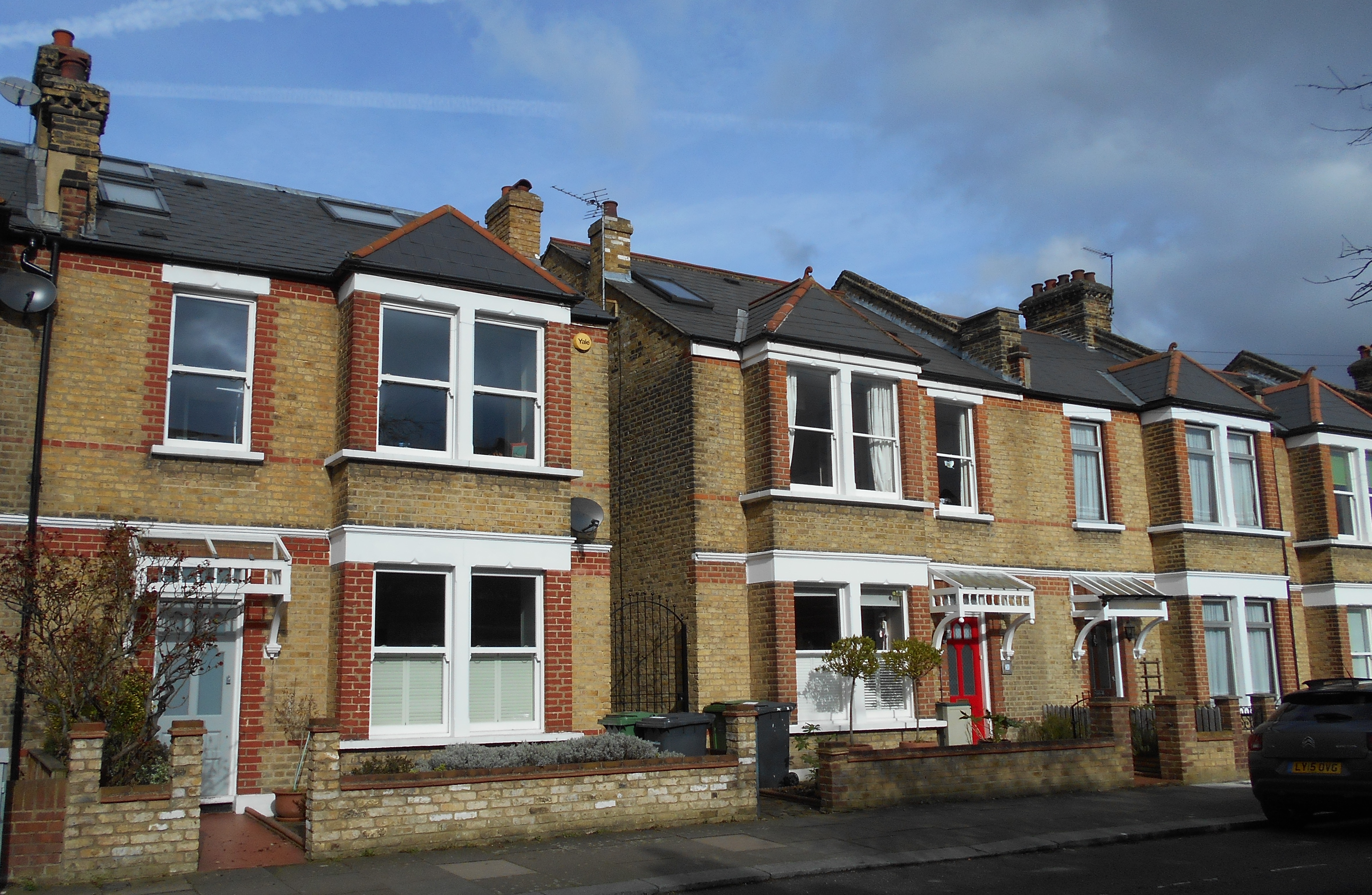
In some locations where World War 2 damage is easy to spot with replacement houses in a different style or large areas of different bricks used – there were brick shortages post World War Two and it was often to get exact matches. The tell-tale signs are less clear here – in a few houses bricks the red brick detail around square bays of the yellow London Brick Co ‘Stocks’ is missing. But the only really obvious signs are on one house above with different window styles and a missing pointed roof to a bay window. That said, a lot of houses on the street are rendered or have painted brickwork which hides what happened underneath.
Census, 1939 Register and related data is via Find My Past (subscription required)
The ARP Log was accessed via the under-resourced, but always helpful, Lewisham Archives
The bomb damage mape is via Laurence Ward’s ‘The London County Council Bomb Damage Maps 1939-1945’ published in 2015 – permission has been given by the copyright owners of the map, the London Metropolitan Archives, to use the image here
The land of Burnt Ash Farm had originally been farmed from a large house which was on the site of what is now Lee Manor House.It was probably not an ideal location for the farm as its land was virtually all to the south – stretching away towards Grove Park.The move to the junction of what is now St Mildred’s and Baring Roads happened in the mid-1720s (1).The remains of the original Farm on Old Road were found underneath the library when some building work was undertaken in the early 1980s.
The shift in location to Burnt Ash was by Thomas Butler who came from Dagenham in, what was then, rural Essex (2). Perhaps as early as 1739, and certainly after Butler’s death in 1751 (3), Burnt Ash Farm was split between two of his sons, Matthew who remained at Burnt Ash and farmed the land south of St Mildred’s Road; and James who was to farm what was to be called Lee Manor Farm.The land was most of the area bordered by Burnt Ash Road, what is now St Mildred’s Road, the stream Hither Green Ditch until it joins the Quaggy, the river itself and Lee High Road.The initial site of the farmhouse was to the west of Pentland House (at one stage called Foclallt House) on what is now Manor Lane Terrace and included the site of Lochaber Hall (on the 1860s map above it is referred to as Manor Cottage).It was a large three-storey house with extensive outbuildings (4). The land was not owned by the Butlers and, as was covered in a post on the Manor House, was bought by William Coleman who sought to recreate the old Manor of Lee for his nephew Thomas Lucas – funded by the proceeds of slavery.Lucas inherited the farms on his uncle’s death in 1771.
On James Butler’s death in 1762 it seems likely that the Farm was again managed by his brother, Matthew, from Burnt Ash (5). After Matthew’s death in 1784 the tenancy of the two farms were taken on by Baron Dacre of Dacre House, whose estates were relatively small.(6) We will return to Dacre House at some point in the future.
Following the deaths of Lord Dacre in 1806 and Lady Dacre in 1808, there were some changes to Lee Manor Farm.Part of the land bounding Lee High Road was sold to the new owner of The Firs, Christopher Godmond, who had bought the House after the death of David Papillon. (7)
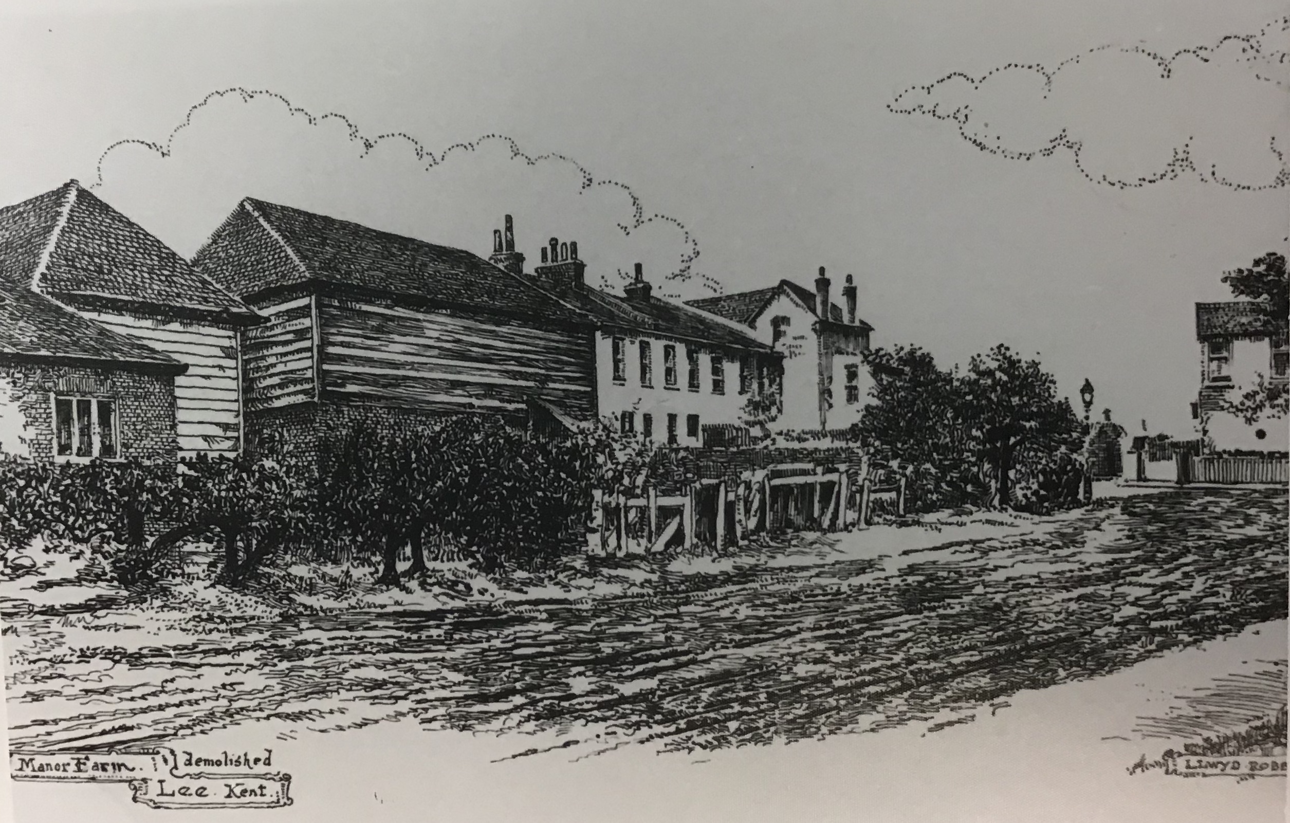
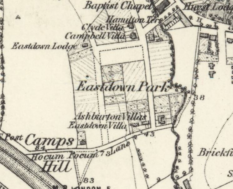
The farm house had be let separately since the 1780s; so when Lee Manor Farm was again let and managed in its own right in 1808, a new farmhouse was needed for a new tenant.The new farmhouse was built on what is now Manor Lane Terrace, between the current Northbrook and Kellerton Roads (it is shown on the map above). The bend in Manor Lane Terrace is explained by the location of the farm. The artists impression of the farm is by Lloyd Roberts (see credits below).
The new tenant was the butler of the new Lord of the Manor, Sir Francis Baring – Thomas Postans (8) – Postans was to stay there until 1816, when he moved on to manage the kitchen gardens of the Manor House to supply the officers mess at St James Palace.Mr R E Brown was the tenant of the farm for this period but Postans returned to the Farm in the mid 1830s.
There is a fascinating map of the farm from towards the end of Thomas Postans tenure drawn with an east – west axis; Lee Green is in the bottom right hand corner with Burnt Ash Road providing the bottom boundary (the other side of Burnt Ash Road was Crown Estate land) and Lee High Road to the right of the map.There is considerable overlap between the 1843 field pattern and the street pattern that emerged in the decades afterwards.
In 1845 a lease was granted to Mark Cordwell who hailed from Buckinghamshire; oddly he was listed as a seaman in the 1861 census with with his 20 year old son, Charles, born in Greenwich, noted as as the farmer.Mark died in 1864.
By 1881, Charles had married Mary (née Peasnell) who was from Buckinghamshire, like his father, and had eight children and a servant living on the farm; the farm was listed at 150 acres in the census. They may have had a bailiff or manager running the farm for them for a while in the 1870s as three children were born in Shoreham in Kent.In the 1871 census they were listed at Prestons Farm Housein Shoreham.
They were back in Lee in 1891; but by the 1901 Census, Charles was listed at 35 Medusa Road in Catford as a ‘retired farmer’ with his son and daughter in law.He may have emigrated to the USA as the last record for him is sailing to New York on the Philadelphia in 1906.
While he may have moved to America, his name lives on in the 1970s council housing that was developed to replace the southern side of Northbrook Road and land behind Kellerton Road – Cordwell Road.
The end of the farm coincided with the gradual sale of of the Northbrook estate from the 1860s onwards.One of the main builders from the mid 1890s were the family firm W J Scudamore.Their developments included what they referred to as the Manor Park Estate (roads such as Kellerton Road, parts of Manor Lane Terrace, Redruth Road (now Manor Lane) and parts of Manor Park.It seems thatthe old Manor Farm came as part of the lot; most developers would have probably demolished the buildings and built over it.However, the Scudamores decided to retain the building as a family home – which it remained as until the 1960s – there is a little more on this in the post on W J Scudamore.
The last of the Scudamores to live in Manor Lane Terrace was Elizabeth (née Drane) who died in 1961 aged 90.After her death, the house and the land around it were acquired for council housing – although all the homes appear to have been sold under Right to Buy. The name Wolfram Close is presumably a reference to the last tenant of the Manor House – the slightly differently spelled Henry Wolffram.
Notes
Josephine Birchenough (1981) Some Farms and Fields in Lee p4
Both the drawing of the farm and the 1843 map of it are part of the collection of Lewisham Archives, they are used with their permission and remain their copyright.
The area bordering Manor House Gardens has a rich and interesting history which Running Past has written numerous posts about. This post was written to ‘accompany’ a walk organised as part of the 2019 Manor House Gardens Festival, it can be used to independently to walk the route (it’s a circuit of around a mile, which can be found here) or as virtual tour of the area. The ‘walk’ is divided into sections which relate to the planned stopping points – each of which is full of links to other posts in the blog which will have more detailed information.
Some Background
Before it was enveloped by the city Lee was a village, a village with three centres – Lee Green, the area around St Margaret’s Church and Old Road, as John Rocque’s map from 1746 shows.
Lee remained largely rural until mid-19th century until the coming of the railways – Blackheath & Lewisham stations opened in 1849, Lee in 1866 and Hither Green not until mid-1890s (it was just a junction before that).
The mid-1860s Ordnance Survey map above shows how little development there was beyond Lee Green and to the south of Old Road; farms remained until the 1920s and 1930s, such as Burnt Ash and Horn Park.
The Manor House
Old Road was once home to a series of large houses, starting from the eastern end these were Lee House, The Cedars, Lee Place, the Manor House, Pentland House and The Firs – geography played an important part, it is on a small hill which would have offered impressive views to the east and south but were high enough to protect from flooding from the Quaggy and the now diverted Mid Kid Brook, which used to flow down Lee High Road.
Lee Place
The first of the country houses was Lee Place; Its building was the result of the death of Lord of the Manor, Brian Annesley who had a moated farm probably where St Margaret’s Lee School is now situated. His later years are believed to at least partially inspired Shakespeare to write King Lear – there was happier ending than in the play though. The estate split up on his death.
Lee Place (above) probably built by/for George Thompson – had links to the slave trade but is better known as a soldier and MP during the Commonwealth brother of Maurice who lived at Lee Farm. It was the home to the Boone family (it was their family chapel) for several generations but was let out from the mid-18th century. Its last tenant was Benjamin Aislabie.
The estate was sold in 1824 as still has an impact on the current landscape as it was broken up into relatively small lots which were developed at different times. It allowed too the straightening of Lee High Road – the straightened bit was known as New Road for several decades
The Manor House
Lee Farm was previously on the site, which moved to what is now the junction of Baring and St Mildred’s Roads in 1727 and became Burnt Ash Farm. The former farm was bought initially by the slave trading brother of George Thomson, Maurice and then by William Coleman who sought to re-create the lands of the old Manor for his nephew,Thomas Lucas, both were ‘merchants’ with strong links to the slave trade.
The Grade II listed Manor House was built on the site of the farm in 1770 by Richard Jupp for Lucas. It was bought by Sir Francis Baring in early 19th century, whose family wealth also had its origins in the slave trade – used it as their near London base – the merchant on the maroon plaque is depressingly vague. The Northbrooks let in out during much of the 19th century
Pentland House was built in early 1790s and is probably the oldest residential building in Lewisham – it is a close run thing with St Mary’s Vicarage though! It has been added to considerably and rendered in the early 19th century when extended.
It was home to the rich, but not that significant Smith family, who sold to some more Smiths, who sold to some more Smiths (albeit with a prefix) – it became a Goldsmiths’ College hall in 1913 which stayed until the early 2000s. It is currently a largely backpackers hostel.
Flats & Houses Opposite
The houses and flats opposite are a bit less grand – Bankwell Road & adjoining bits of Old Road – completed in 1908, possibly by James Watt – it was the central of three plots of land bounded by Lee High Road and Old Road – as the 1890s Ordnance Survey maps below shows.
The eastern of the plots are Arts & Crafts style flats which are a bit out of kilter with rest of area. The land they were built on had been part of Lee Place – the house itself was on this part. The land was bought as an orchard and kitchen garden for Pentland House with the flats & Market Terrace on Lee High Road built in the mid-1930s.
Before moving on worth reflecting on the library, the park and indirectly the rest of the current urban landscape was paid for by the slave labour in the plantations of the Caribbean owned or traded by those that lived here and over the road.
On the way to Lochaber Hall at the first house on Manor Lane Terrace look at the wall – the remains of a sign pointing towards air raid shelters in Manor House Gardens (more on that later).
Lochaber Hall, the Firs, Holy Trinity
Lochaber Hall
If think Lochaber Hall looks like a church hall you’d be right, it was originally church hall for Holy Trinity in Glenton Road (pictured below). The church was destroyed in the Blitz and is now Callaghan Close (almost opposite the Telephone Exchange) and named after the 1970s Prime Minister who lived in Blackheath.
The Hall was designed by Ernest Newton, a locally renowned architect and President of RIBA, he also designed St Swithuns, the original Church of Good Shepherd and Baring Hall at Grove Park. Slightly surprisingly it is Grade II listed. Immediately after World War Two it was used as a hall for the Church of the Good Shepherd as that church was largely destroyed in a fire & the congregation was using the adjacent hall as the church.
The Firs Estate
The Firs was another of the large country houses of Lee, it was a large red-brick house which was a built around 1700 as the ‘town’ residence for the Papillion’s, a prominent Huguenot banking family – it stayed in the family’s ownership for a century. The last owner from the mid-1860s was John Wingfield Larkin, a member of a wealthy Kent family who had been a merchant in Egypt and British consul in Alexandria between 1838 and 1841. The family sold up on his death as the city encroached in 1893.
It was developed as Murillo, Old, Rembrandt & Lochaber Roads by the end of 19th century. It is not certain who the builder/developer was – although is a stained glass for Siderys on Murillo Road – who were prominent builders in the area.
The houses on the corner of Manor Lane Terrace and Abernethy were largely destroyed on the 1st night of the blitz. 27 Murillo Road was home to one of the more prominent Lewisham suffragettes – Caroline Townsend.
Lee Manor Farm
This was originally at the Manor House, moved to what is now the junction of St Mildred’s Road and was renamed Burnt Ash Farm in 1727; that farm was split in the early 19th century and new farm buildings constructed opposite The Firs (close to the current junction of Manor Lane Terrace and Manor Lane). It didn’t stay the farm house that long and we’ll return to it at our next stop.
Junction of Manor Lane Terrace & Kellerton Road
Manor Park Estate
We are in the land of W J Scudamore here and along with John Pound are probably the two firms of builders that most influenced the area – buying land from the Northbrooks. W J Scudamore were based on Manor Lane (corner of Handen Road) then Lee High Road (part of Sainsbury’s site) and latterly on Holme Lacey Road in Lee and active in Lee, Hither Green and later elsewhere from the 1890s until the 1930s.
The Manor Park Estate (as the roads around here were originally referred to as) was built for a mixture of rent and sale – sale prices were £265 or£275 for the bigger ones – it was 1906…!
They definitely also built
Shops on Manor Lane (eastern side)
Newstead Road
Some of St Mildred’s Road
Holme Lacey & Dalinger Roads
Several small sections of Leahurst, Longhurst and Fernbrook Roads
Probably lots of others too
Wolfram Close
On the site of the last location of the Lee Manor Farm (pictured below) – the land farmed was to the south of here. The farmhouse seems to have been sold with the land for the Manor Park Estate and became a home for the Scudamore family who remained there until 1961.
The site was redeveloped in the 1960s or early 1970s, it isn’t clear whether this was by Scudamores, as they went into liquidation in 1966. It is presumably named after the last occupant of the Manor House – Henry Wolffram from Stuttgart who ran a ‘crammer’ school for would-be army officers – the spelling of his name is incorrect though – the cul de sac as one ‘F’ the name two ‘Fs’.
The council estate behind Cordwell Road – is named after one of the last farmers of the farm.
Manor House Gardens
The park was created in the early 1770s as gardens for the Manor House until 1898 when the Northbrooks sold up to the London County Council (LCC), which as with Mountsfield Park on the Hither Green and Catford borders wanted to ensure that the newly developing suburbia had parks and libraries provided. The Gardens had been left in a poor state by last occupant (Henry Wolffram) and didn’t open to the public until 1902.
Source – eBay Feb 2016
It contains a rather impressive Ice House which was used as an air raid shelter in World War Two; there were a couple of other ones too, the outline of one of them was visible in the parched grass in the hot weather of 2018.
The Gardens have been ‘listed’ since 1987 and underwent a major refurbishment in 2000. The small lake has been part of grounds for most of its post agricultural life. The River Quaggy flows through the Gardens, it used to be at a higher level but the bed was excavated partially to reduce flooding – probably in the 1880s.
Behind the library, there are two little bits of Catford – foundation stones for the now demolished St Laurence Church and the original Town Hall.
Lenham Road/Lammead Road Corner
If we were standing here in the 1870s we would be in or next to the River Quaggy as there was a meander that originally came up to this point. It was straightened in 1880s both to allow development but possibly too as flood prevention measure – there were really bad floods in 1878.
Most of housing on Lenham, Lampmead (and Aislibie that will walk up) Roads dates from late 1880s when Lee House (more on that later) was demolished and the land sold for development. It was slightly different on the other side of the river – Robertson Street, now Brightfield Road probably dates from the late 1850s or early 1860s.
The houses at the corner are very different – early 1960s council housing as opposed to late Victorian. This was because early in the morning of 22 June 1944 a V-1 flying bomb hit the corner, killing 6. There was a lot of Blitz damage on Lenham Road as well as on Aislibie Road where there are several bits of infill council housing from the late 1950s or early 1960s.
49 Lampmead (above) was home to Phyllis Noble who was to become Phyllis Willmott and wrote a 3 part autobiography about growing up in Lee in the 1920s and 30s – this has been covered a few times – including in relation to the Sunday Constitutional and children’s play.
Almsot opposite, at the junction with Aislibie Road in 2016 a house had Blitz type damage as a result of badly executed building work.
Lee Centre
Lee House & Centre
This was originally the site of Lee House, a medieval mansion that was rebuilt in the 1820s probably partially as a result of the re-alignment of Old Road, it is pictured below. However, by the 1880s it no longer met the needs of the wealthy Victorian gent as city encroached with the railways.
Lee Centre was built on the site in the 1880s – initially it was home to a few clubs, including a chess club. But it was never developed uses that befitted its impressive architecture by World War 2 it had effectively become used for storage and nurse appointments; it was used for education from 1970s and more recently by various charities.
Next door was built as St Margaret’s Parish Rooms, long before Kingswood Halls were built; it was also home to school for many years before becoming offices and warehouses for stationery supplier and then a toy merchant. It has been a nursery for the last decade or so.
Chiesmans’ Warehouse
In a former incarnation this was home to the teetotal Lee Working Men’s Institution, it was taken over as a depot for the Lewisham Department Store, Chiesmans who rebuilt it around 1914 – it was almost completely destroyed in during the Blitz before being rebuilt on same footprint for Chiesmans in mid 1950s. After some slightly less than legitimate activities it is slowly being converted into flats.
The Cedars
Was situated on what is now the opposite corner of Aislbie Road, it was another large house – the estate was broken up and mostly sold at the same time as Lee House. The house itself remained until the 1890s before being sold for development – hence the housing at the north-western corner of Aislibie Road is different to the rest of the street. The street itself was named after, although spelled incorrectly, the slave owner and terrible cricketer Benjamin Aislabie – the last tenant of Lee Place.
Manor House Gardens (Old Road entrance)
This is next door to 36 Old Road, this was part of the estate of The Cedars. Post development the site was used for many years as stables for Thomas Tilling’s horse drawn buses and then as a workshop by the firm afterwards. It went through several uses afterwards – the sweet makers Whitehouse and Co from 1929; John Edgington and Co Marquee Manufacturers who latterly made floats for the Lord Mayors Show were there from 1949 (including some of those below) and then Penfolds used it as a crash repair workshop from the late 1980s until around 2010. Development into flats started a few years later but has been paused for a couple of years.
Picture Credits
John Rocque’s 18th century map is from the information board at Lee Green
The Ordnance Survey map from the 1860s is on a Creative Commons via the National Library of Scotland
The picture of Lee Place comes from the information board opposite St Margaret’s Church
The picture of Holy Trinity Glenton Road is via Wikipedia Commons – originally from Illustrated London News
The photograph of The Firs is from the information board on Brandram Road, opposite St Margaret’s church.
The drawing of Lee Manor Farm is part of the collection of Lewisham Archives, it remains their copyright and is used with their permission
The 1890s Ordnance Survey map is courtesy of the National Library of Scotland on a Creative Commons.
The pair of Ordnance Survey maps from 1863 (top) and 1893 are on a Creative Commons via National Library of Scotland
The sale plan of Lee House is part of the collection of Lewisham Archives, it remains their copyright and is used with their permission
The river changes here; gone now are the almost bucolic feel of the river through the playing fields and parkland in the section of the river from Sutcliffe Park to Lee Green. The Quaggy is now very much an urban river, with building up to the banks and the route downstream for the fluvial flâneur often parallel with the river only visible on bridges.
Riverside pubs have been conspicuous by their absence so far, but are a much more regular feature as we follow the last mile or so of the course. The Old Tiger’s Head, 50 metres or so away from the river, was the base for the mid 1840s horse racing of the Lee Races. Lee Green was still rural then, complete with a green, a windmill and a farm – Lee Green Farm. The pub was very different then, being rebuilt in the 1890s, as the picture above from an information board at Lee Green shows.
The Quaggy squeezes between some 1990s flats and a plot of land that was Victorian housing and will presumably be returned to housing again; it was latterly the showroom of Penfolds Vauxhall dealers, after they moved from the former Lee Picture Palace on the corner of Bankwell Road. The river, for a short period, is again banked and bedded in concrete – little is able to grow but that didn’t stop a few optimistic sticklebacks from attempting to eke out an existence in a hostile environment (below, top left) when I did the research for the post.
The Quaggy emerges out into the open at what used to be called Lee Green Bridge and the first proper riverside pub, the Duke of Edinburgh, still serving and with a pleasant garden at the rear. The pub dates from around 1871 when the landlord, a Mr W Baker, took over licence of the Black Horse, which was a short-lived ‘beer house’ that may have been on the same site (1)
The river forms the rear boundary between homes in Lampmead and Brightfield Roads – the former named after a field. The course wasn’t always thus, the Quaggy originally took a course further to the north touching the southern end of what is now Lenham Road. The differences are clear between the 1863 (top map below) and 1893 visits of the Ordnance Survey Cartographers (maps on a Creative Commons via National Library of Scotland). The effective development of Lampmead required the straightening of the river, following what was previously a path behind the houses of Robertson Street, which was to become Brightfield Road at around the same time. The curved building (above, top right and bottom) hugs the banks of the river.
The Quaggy seems to have originally fed the small lake although is now at a much lower level. It is bridged a couple of times within the park, both having been the venues for generations of Pooh Sticks, no doubt played before the game was named in the 1920s by A A Milne.
The river has natural earth banks topped with a dense tree canopy throughout its 400 metres or so through the park, during the summer the river is heavily shaded. The steep banks make the river relatively inaccessible through the park.
Flowing out of Manor House Gardens, the river crosses Manor Lane, an old farm track and again forms a boundary – between the WJ Scudamore homes of Thornwood Road, a Lewisham Council sheltered scheme off Manor Lane and later more Scudamore homes on Manor Park. This was a largely rural area until Hither Green station was build in the 1890s, there was a junction there from the 1860s, as the 1870 map below on a Creative Commons from the National Library of Scotland) shows. This part of Lee was still used for market gardening, mainly run from Manor Farm, until the Scudamores built homes of what was marketed as the Manor Park Estate..
Over the other side of Manor Park the river turns almost 90 degrees, to flow between more gardens, between Manor Park and Longhurst Road, briefly visible by peering around a bridge on one side of Staplehurst Road – close to the shops posted about earlier in 2017. Just before the bridge the river is joined by one of its tributaries, Hither Green Ditch (Quaggy Hither Green).
The river continues northwards, squeezing between the gardens of Manor Park (the street) and the northern end of Longhurst Road before opening out into Manor Park (the park rather than the street). The park’s rejuvenation has been covered before in Running Past, the former small pig farm has gone from one of Lewisham’s worst bits of open space to one of its best. The Park has become a community hub – centred around the Arts Cafe. The river itself is used much more – including the annual Quaggy Duck Race and the Float Your Boats event in June 2017, pictured below.
The Quaggy itself while having a ‘natural’ feel at the end of the back gardens of Leahurst Road, was concrete encased and hidden from the park on the opposite bank. Flooding used to be common in this area – in the mid-1960s, the then MP for the area Chris Chataway described residents as living ‘in fear of this wretched stream.‘
At the edge of the Park, there is a bridge – while the structure is a new one, the crossing an old one – it was the final section of Hocum Pocum Lane – an ancient path from Lee High Road to St Mary’s Church, and possibly beyond.
We’ll leave the Quaggy here for its final section to its confluence with the Ravensbourne in Lewisham.
Notes
Ken White (1992) ‘The Public Houses of Lee and Lewisham’ Part 6a, p134
There were several builders and developers that made signifiicant impressions on the urban landscape of Lee and Hither Green – on the western side of the railway was Cameron Corbett’s development of North Park Farm in Catford and Hither Green, on the eastern side of the railway mainly on Northbrook land was John Pound. Straddling both sides and having much greater longevity in terms of years of operation were the family builders WJ Scudamore and Sons. The family retained connections in the area until at least the 1970s. This post looks at both their lasting impact on the built environment, but also in tries to unpick some of their own story which is closely intertwined with their development of homes.
The firm appears to have been founded by William John Scudamore who was born in 1845 in Whitechapel – he married Harriet Stevenson in 1865 and together had eight children, only four of who lived beyond childhood. The three surviving sons all became Directors of the firm – William John (1867), Cornelius (1871) and George (1873).
William (1845) was living in at 37 Henry Street in St George’s area of Borough in Southwark working as a blind maker in the 1871 census; a decade later, the family had moved to Bermondsey New Road where William (1845) was then listed as a furniture dealer.
William’s (1845) first wife Harriet died in 1896 and he married Elizabeth Drane in 1898, in Southwark. They had two further children – John William (1899) and Henry (1904) who were born in Catford and Lee respectively – as with the other sons, they were to become Directors of the family firm.
While there seems to be no reference to William (1845) in the 1891 census, it would seem likely that the building firm had already been set up – certainly, his son William (1867), who had married Annie Elizabeth Jackson the previous year, was listed as a builder living at 226 Old Kent Road – possibly for his father.
The first definite location in Lewisham that it is known that W J Scudamore developed was on the site of the former Hope Cottage on Hither Green Lane. The plot was about 5.5 acres in size and (1) saw the development of the shops fronting Hither Green Lane and the flats above them, along with Woodlands, Benin and Blashford Streets (2). There is a specific post on Hope Cottage and Woodlands Street.
As can be seen from a newspaper advert further down the post, 1 Benin Street (below) was used for a while as the Estate Office. It seems that this development predated adding the ‘Sons’ to the business as there were mentions of paying bills of £20 in 1898 and £6 11s 6d in 1899 for connection of sewers.
By 1901, William (1845) had moved to the then suburbia of Catford and was living at 157 Brownhill Road, with his new wife. His sons from the first marriage were all close by – William (1867) was living at 144 Laleham Road, Catford, and had a daughter, also Annie, who had been born in Southwark around 1894 and a son, also William John, born around 1897 in Catford. His brother, Cornelius was living just around the corner at 45 Farley Road, like his brother he was listed as a builder in the census – although the family history notes that he was an ‘administrator and designer of the houses.’ The youngest brother, George, carried the same ‘trade’ in his census listing in 1901 and was a few minutes away from his brothers at 155 Hither Green Lane.
In Lee they built 53 homes on Effingham Road (presumably the westen end) ust before the turn of the century – there were requests for adoption in July 1899 (3) and being let by September 1899 – they were offered on annual rents of £28 for mid terraced homes, £29 for those with a side entrance (4).
By early 1904, probably before, the firm, now including the ‘Sons’ were at 13 Manor Lane, now 89/91 after Redruth Road became part of Manor Lane (5) They were using it as an estate office for various developments in the area; William (1867) seems to have lived there and had another son Harold who was born there. It is on the corner of Manor Lane and Handen Road and was a convenience store up until around 2018 when it became a nursery. Given the similarity of some of the architectural details, it would not be surprising if the property was build by the Scudamores. The same is true of shops 103 to 109 Manor Lane which are of the same style.
There were advertisements in the London Press in 1906 for four bedroom homes at rents of £40 a year (6), presumably in the now well established Effingham Road.
Within a year or two they were advertising homes for sale on what they referred to as the Manor Park Estate (7).
The Manor Park Estate would seem to include roads like Thornwood, Chalcroft (below) and Kellerton Roads along with parts of Manor Lane, Manor Lane Terrace and Manor Park – the last three were all to become home to family members once the building work was completed.
In the same editions of the South London Press (8), they were also also letting homes in Benin Street and presumably above the neighbouring shops on Hither Green Lane.
By 1911 the brothers were all living around Lee – Cornelius had moved to Southbrook Road, William (1867) was at 89 Manor Park and George a few doors away at 127. Their father, William (1845) was living close by at 79 Micheldever Road.
By 1915, they were operating out of 412-414 Lee High Road – they used it both as an office as well as a store and workshop for making windows. It is where Sainsbury’s is now but was acquired by Penfolds – a couple of doors down from the Imperial Picture Palace and next door to the former Police Station, During that year they bought several pieces of land and buildings in Newstead Road although, while the Scudamore interest was noted as a builder this may have been completing transactions on work completed several years before – OS maps show Newstead Road being built around the mid-1890s. Examples on the link are for 45, 47, 59 and 67 but there were several other similar transactions.
Given the similarity of houses on the neighbouring Parkcroft Road (below) and St Mildred’s Road to houses they built in Manor Park and Chalcroft Road – it is likely that they are the work of W J Scudamore & Sons too.
Newstead Road may have been the first development in the area as the history of the family name notes that the early approach to building was to lease plots on which he built houses.
Around this point William (1845) moved into a large house at 38 Manor Lane Terrace, with gardens and tennis court – it was the former Lee Manor Farm – adjacent to homes that the firm had built and perhaps bought with the land for them. The house was demolished, probably after Elizabeth died in the 1960s (William, 1845, had died in 1824), and is now part of Wolfram Close – probably a misspelled version of the name of last occupant of the Manor House (now library).
William (1867) and Annie moved to Baring Road (presumably built by the firm), and by 1928 had retired – they are recorded on a couple of passenger lists going to North Africa and listed as having had no occupation.
The business seems to have been taken over by William John (1897) – the business, at least, was based at 1 Burnt Ash Hill, next to the station – convenient for sales to commuters.
In the 1920s and 1930s they were building some of the newer homes of Lee – including homes on what was then referred to as the Northbrook Estate, opposite the Northbrook Park on Baring Road (see picture below). An advert offered the 3 bedroom homes at £725 for leasehold at £875 freehold – stressing the relative proximity of both Grove Park and Lee Stations. It was almost certainly part of the land of College Farm, which Running Past has covered in the past.
William John (1897) was also extending their area of operation – particularly into Bexley, during the mid to late 1930s they developed sites at
William John (1897) married Dora and had two sons and a daughter, William John who was born around 1923, he died training as a member of the Glider Pilot Regiment in 1942. Like many of the rest of the family they lived in a Scudamore house – they were listed in the 1939 Register as living at 2 Dallinger Road (below), development of that road had started in 1914 (9). The street was named after a scientist and Methodist minister, William Dallinger, who lived locally towards the end of his life. It is on the corner of another street the firm built – Holme Lacey Road – which is a misspelled reference to the historic home of the Scudamores – Holme Lacy in Herefordshire – the development of that street was a lot later – around 1928 (10).
Cornelius was listed as living at 156 Halfway Street in Sidcup on a passenger list to Brisbane in 1938, presumably to visits his son, also Cornelius, who emigrated to Australia. He was listed as a Master Builder (Retired) at the same address in the 1939 Register. He died in 1958 in Greenwich. William (1867) seems to have come out of retirement as he was involved with the firm in 1939, living in a large house close to Sevenoaks – one of the other occupants was his son Harold, who was listed as a Scudamore Director. William (1867) was to live until 1955. George had retired by 1939 and was living in Footscray Road – he died in Bromley in 1950.
Nothing is known of what happened to the firm after World War 2 although they continued in business until 1966, when they were based in Holme Lacey Road – probably where Travis Perkins are now (2017) trading from. The firm was voluntarily wound up on 18 July 1966 and a liquidator appointed – when William John (1897) would have been around 69 and was still Chairman of the business at the time of the winding up. William John (1897) was to live until he was 90.
The Scudamores left their mark in other ways than the homes – they had bespoke manhole covers at the rear of the homes they developed, and excellent Edith’s Streets suggested that they also had them on the roads of the estate. Sadly, despite a ferrous foray around the streets of Hither Green and Lee looking for evidence. Alas, dear reader, I found no evidence of the latter. However, in the back gardens the former still exist with the Manor Lane address.
Notes
Godfrey Smith (1997) Hither Green – The Forgotten Hamlet p35
ibid p39
Kentish Mercury 28 July 1899
Kentish Mercury 29 September 1899
Kentish Mercury 29 January 1904
London Daily News 28 June 1906 – there were several of the same adverts around then.
South London Press South London Press 29 January 1909 – the same advertisement was used for several months.
ibid
Joan Read (1990) Lewisham Street Names and Their Origins p17
ibid p29
The elements of the family history have been gleaned from two sources – the census, shipping, marriage and related data came via Find My Past
The most important sources have been the fascinating Scudamore Family history along with various members of the Scudamore family who have enabled me to piece together strands that I had originally not been able to link together.
Thank you also to Nick Noel for the photograph of the drain cover.


