There is an interesting group of buildings that are locally listed at the Burnt Ash Road end of Woodyates Road, it comprises of some former council offices and a former Royal Mail sorting office. The group was covered in passing on a post on the development of Woodyates and Pitfold Roads in the 1930s. This post looks in a bit more detail at the Parish Offices which are pictured below.
Lee was a Civil Parish whose bounds were ‘beaten’ in Running Past in 2020 – following an Ordnance Survey map from the 1890s. It was a small parish and so for a lot of the limited range of public services offered they were undertaken jointly with other parishes – the workhouse as we saw in the post on the Lesters of Lee New Town was a joint one with Lewisham and several other parishes. The Board of Works was a joint one with Plumstead, Kidbrooke, Eltham and Charlton who had their own office in Charlton Village. The parish does not seem to have had any offices before the one in what is now Woodyates Road. For example, requests to inspect tenders relating to Lee were directed to the home office of the Sureyor to the Board – Francis Freeman Thorne who lived at the large house, Rosebank, Lee Road (1). The house was demolished post war.
Plans started to be drawn up in 1882 for offices and various associated buildings, including stables, with the tenders going out in early 1883. Lee was a long narrow parish and the site chosen was close to the station which opened in 1866. The land had originally been part of Lee Green Farm, but the Crown was putting it to other uses – a mixture of substantial homes and market gardening – the latter run as part of Maller’s Nurseries. However, this was not some rural idyll as it had been part of John Pound’s brickworks and there was a clay crushing machine on or close to the site. At around the time of the building, the land opposite, where Woodstock Court now is, was being used by the Parish as a ‘mud shoot’ – effectively as dumping ground for mud, manure and the like from Lee’s roads – presumably filling up the hole from the brickworks
So, who were the people behind the plans? The Lee members of the Board of Works were a mixture of wealthy business people who had moved to what was then suburbia and some of the more established trades and shop keepers:
William Thomas Gates was a well-known local builder living on Eltham Road, amongst other things he built the Lee Working Men’s Institution
Francis Hosier Hart was the agent for the Penns of Cedar House on Belmont Hill, he was also a historian, lived on Brandram Road
James Richard Lloyd lived on Belmont Hill and was Lee’s representative on the Metropolitan Board of Works in addition to being a Director of an insurance company
Henry Richard Wright was another builder, who in 1871 was living with his brother at the Royal Oak in Lee Church Street,
Frederick Booker was a ‘China and Japan merchant’ living in Blessington Road
Alfred Cooper Cole was a pharmacist who lived on Lee High Road
Benjamin Maller ran nurseries on the land that was previously farmed from Lee Green Farm and lived ‘on site’ in Leyland Road
William Brown was probably the fruiterer, greengrocer, and coal seller trading from what is now the Sainsburys site on Burnt Ash Road
The Board of Works had asked eight firms for prices, they were mostly local, but names included firms that would become well known, including Mowlem and Co. The successful tender accepted from S J Jerrard builders of Lewisham, their price of £3973, was almost £300 cheaper than the next lowest (2).
Samuel Jerrard was based at 40 Loampit Vale (on the eastern corner of Thurston Road, where a large sudent accomodation block is now situated), the firm’s main area of operation was in Ladywell – building much of Vicars Hill, Embleton, Algernon, Algiers and Ermine Roads in the 1880s and 1890s. His best-known construction in Lewisham is the Clocktower built for the Diamond Jubilee of Queen Victoria in 1897.
Returning to the offices, the building and associated costs including stabling for a dozen horses, sheds for carts and so on were to be paid for by loans, mainly over 34 months from the Metropolitan Board of Works (who oversaw major capital works across London), in total, £6705 was borrowed (4). In terms of 21st century loans for capital works this seems like a very short period. In addition to the building costs, another £227 was borrowed (5) presumably for the costs of Clerk of Works, James Robinson. Another £1500 was borrowed for purchasing horses, carts, and associated harnesses (6) repayable over 12 months (7).
The parish decided soon after works started that the horse keeper should be based on site (8).
The structure of the offices was completed by the end of November 1883, as the Parish met there on 30 November; but there was still a fair amount to do though in terms of furniture, gas supply and so on. The Sanitary Inspector, Walter Bridgen, was to be invited to be caretaker – living on site, rent free but contributing to bills (9). A successor role as inspector of roads was advertised at £2 2s in 1893 and ‘reasonable use of coals and gas.’ (10). The location and layout of the completed offices is visible from the 1890s Ordnance Survey map below, behind shops fronting onto Burnt Ash Hill – the former Lee Public Halls is visible opposite as the laundry (currently part of Travis Perkins site, but in early 2023 about to be demolished.
Lee was to become an authority in its own right in 1894 and in 1900 it became part of the Borough of Lewisham into whose ownership the offices passed. In the census the following year, Henry Butcher was listed as ‘Horse Keeper (Borough Council)’ – he was 40 and from Storrington in Sussex – he was there with his wife Ellen and nephew William Knowles, a harness maker, aged 22 from Sussex.
Also living on site in 1901 was Thomas Whebby, he was a Sanitary Inspector for the Council from Dorset, aged 51, he was there with his wife Alice and 5 children aged between 10 and 24, all born in Yeovil. Thomas Whebby remained there in 1911 and there were still people living on site in the 1939 Register -John Bain 35 was listed as a ‘Municipal Officer – Inspector if Works’ – marked as 1-7 Woodyates Road, rather that the Woodstock Road it was built on.
Perhaps, surprisingly, horses were still being used by the Borough Council in 1939 and at what was described as 9 Woodyates was the person looking after them, horse keeper, Richard Short, who got the ‘heavy work’ supplement entitling them to more rations during World War Two.
During the war the buildings were used as a base for the Air Raid Precautions unit – the horse carts are visible at the back of the photograph below.
Much had changed in the area around the Depot by the time war broke out in 1939 – the fields, later allotments and nurseries had been sold for housing by the Crown Estate – Woodstock Road had become Woodyates Road as part of the Woodstock Estate. Opposite the Council yard the former ‘mud chute’ was to become the rather elegant art deco Woodstock Court.
The building remained in council use until the 1980s when the lease to the Crown Estate expired. We’ll cover the late 20th century redevelopment as Jasmin Court in a subsequent post on the Sorting Office next door.
Notes
Kentish Mercury 10 May 1879
Woolwich Gazette 3 March 1883
Kentish Independent 22 January 1887
Kentish Independent 17 March 1883
ibid
Woolwich Gazette 27 April 1883
Kentish Independent 17 March 1883
Kentish Independent 26 May 1883
Kentish Independent 15 December 1883
Woolwich Gazette 18 August 1893
Credits and acknowledgements
Census and related information is via Find My Past (subscription required)
I am indebted to George Willis who lives in Jasmin Court (the 1990s development that the offices and stables are now part of) who has researched the site – although most of the research for this was in parallel so any errors are obviously mine. Thank you also to Darryl from the excellent 853 news blog for putting us in touch – if you don’t follow 853 you are missing out!
There is a postcard that appears from time to time on Lewisham Facebook reminiscence groups and for sale on eBay of a small house set back from the road with the label Burnt Ash Hill. In the former locations, it often causes consternation as there are no obvious current or even recent landmarks. The house was Wood Cottage and this post seeks to tell at least some of its story, and more particularly the nurseries that it was linked to.
The cottage probably dates from the 1870s and was broadly where the Roman Catholic Church of Our Lady of Lourdes now stands (pictured below) – midway between Lee Station and what is now the South Circular of St Mildred’s Road and Westhorne Avenue.
The origin of the name is unclear, although the most likley scenario is after one of the Wood family who farmed the neighbouring Horn Park Farm who may have farmed the land for a brief period in the 1860s.
The firm running the nursery for much of its life was Maller and Sons. It was set up by Benjamin Maller, a gardener who hailed from Surrey (Sussex in some censuses). Born in 1823, he was living with wife Mary and daughter Mary at Belmont Lodge in 1851 – which was attached to Belmont a large house on what is now Belmont Hill, where he was the gardener.
In the 1861 census, Maller had moved just down the hill and was listed at 5 Granville Terrace, later it was to have the address 61 Lewisham High Street. It is now part of the Lewisham police station site, but before that, became part of the Chiesmans empire. Maller was listed as a ‘Nurseryman employing two boys’ in the census. Long and Lazy Lewisham which is covering the history of the High Street, notes that he had been there, trading initially with Robert Miller for around 5 years.
The partnership with Miller was short lived as was another with George Fry which ended in 1860. The next decade saw a rapid expansion, the 1871 census suggests he was employing 31 men and 6 boys.
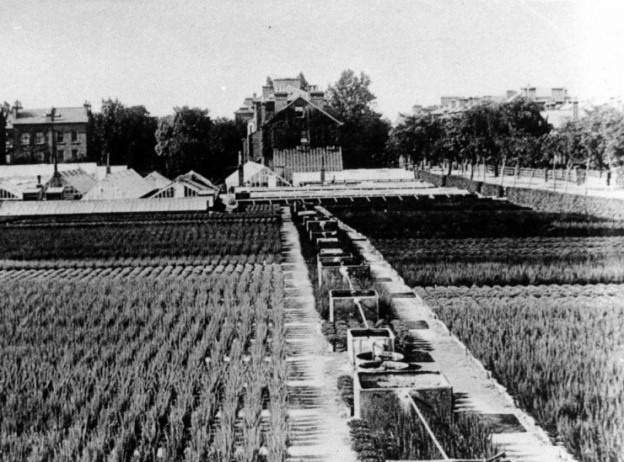
By 1881 they were listed in the census as being in Leyland Road – the numbering isn’t totally clear as the road was being developed and the house is just described as ‘The Nursery.’ This is pictured above (back middle), it was later numbered 72 and puts it now at the corner of Leyland Road and Alanthus Close. The nursery shown on an 1890s Ordnance Survey map. below, along with several other areas cultivated.
This would have been land leased from the Crown, part of the former Lee Green Farm (pictured below) which ceased operating in the1860s. While the exact geography of the farm isn’t completely clear – it seems to have been a narrow farm covering land to the east of what is now Burnt Ash Road and Hill from Lee Green to around Winn Road. Just a few hundred metres wide, it shrank rapidly as homes and shops were developed by John Pound following the arrival of the railway in Lee in 1866. Land was also temporarily lost to clay pits and brickworks just south of Lee Station and north of The Crown.
In 1881 Maller was listed as a nursery man with 30 acres employing 4 men 8 boys. The family included grown-up children Mary, Benjamin and Herbert – in the 1881 census at ‘the Nursery, Leyland Road’.
There had been of significant reduction in labour since 1871 – 31 men to just 4 over 10 years. This probably relates to the land they cultivated being rapidly lost to Victorian suburbanisation as streets like Dorville, Osberton and Leyland Roads were developed.
Benjamin died in 1884 but the business continued as B Maller and Son afterwards, with Benjamin Boden Maller in charge – living variously at 107 and 111 Burnt Ash Road (there was access to the site from Burnt Ash Road too) and 72 Leyland Road. Benjamin Boden Maller died in 1913 although his son, also Benjamin, continued for a while. However, in the 1939 Register he was listed as a Civil Servant living in Reigate.
So what did they grow? In 1879 an advert in the Kentish Mecury suggested the land cultivated from Wood Cottage (Burnt Ash Hill site) was for roses. The site around Leyland Road (listed as Burnt Ash Lane) was used for trees and and shrubs as well as having greenhouse plants and other plants that needed warmth – stove plants. While they cultivated Brockely Nursery they had moved from there as the Billinghursts (see below) were there by 1880 (1),
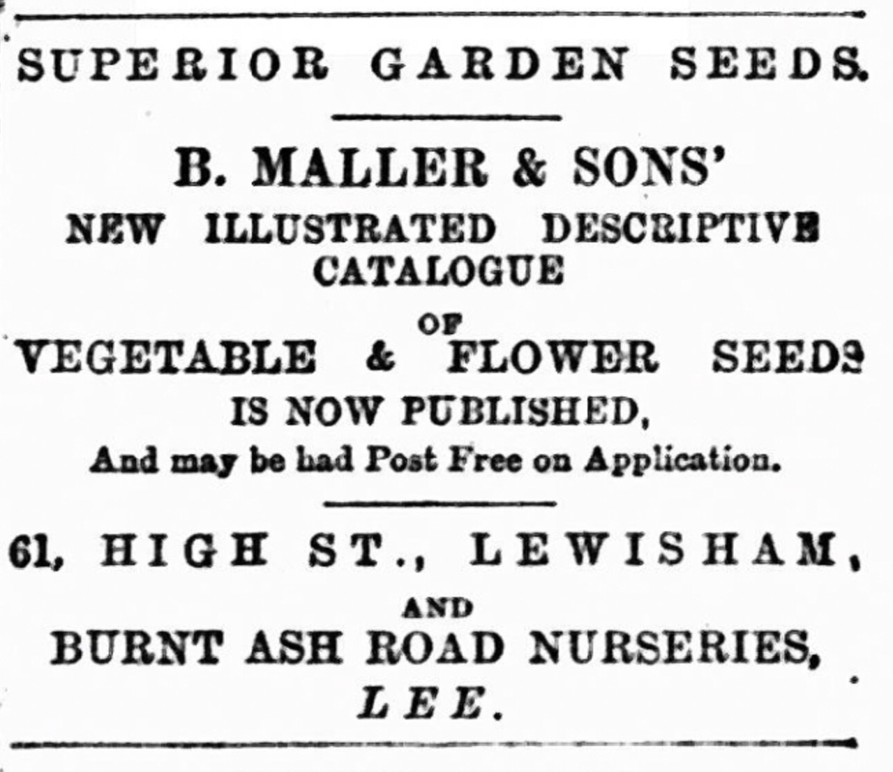
It seems that before the end of the century there was a change in focus with a lot of plants being grown for seed – they were regualrly advertising their illustrated seed catalogue to the gardeners of south east London and beyond (2).
In the early 20th century, they would also have auctions of surplus stock in September each year. The 1910 sale included 20,000 winter blooming heaths, gorse, winter aconites, ferns and palms (3).
The land that is now part of Alanthus Close seems to have remained with the Mallers until around the mid 1920s. On Burnt Ash Hill they will have added the land of the former brickworks less the frontage onto Burnt Ash Hill and a development next to The Crown centring on Corona Road. This will have been an extension of the land cultivated from Wood Cottage.
It seems that the land was split three n the mid to late 1920s when the Mallers left. There were different names at 107 Burnt Ash Road (May Scotland), 111 Burnt Ash Road (George Friend Billinghurst) and Norris Buttle at Wood Cottage.
May Clark Scotland was appropriately Scottish, born in Perth, she was running a florists at 111 Lewisham High Street by 1911, the name over the door was Alexander Scotland.
George Billinghurst was born around 1871 and seems to have spent his early years in Eliot Place in Blackheath, his father Friend Billinghurst was also a gardener. There is no obvious link to the more well known Blackheath Billinghurst family, which included disabled suffragette (Rosa) May. They seem to have cultivated Brockley Nursery for a while (4), after the Mallers moved out, but family moved on to Croydon. By 1891 George was listed as a gardener, a decade later a florist and by 1911 a nurseryman living in Annerley Road.
Norris Buttle was living at 172 Ennersdale Road in 1901 and at 31 Leahurst Road in 1911 (these were probably the same house as the Ennersdale originally dog-legged around) – he was listed as a gardener then nursery gardener.
With all three of them, details beyond 1911 proved difficult to work out. Certainly none of them were at 72 Leyland Road – it was empty in 1939 as were 8 out of 10 the houses of that end side of the street going southwards. It was a different picture going northwards.
The land sandwiched between Leyland and Burnt Ash gradually was encroached upon with development at the southern end of Leyland Road although there were memories of roses being grown until the early 1960s when many Crown Estate leases ended.
And finally, while no longer cultivated, there is a small piece of undeveloped land where the nursery was – the green space to the south of Alanthus Close. On some satellite images of the area in drought conditions show rectangles, probably the ghosts of greenhouses past – a little less clear than the prefabs around Hilly Fields.
,
Notes
Kentish Mercury 16 August 1879
Kentish Mercury 09 February 1894
Kentish Mercury 02 September 1910
Croydon Guardian and Surrey County Gazette 3 July 1880
Credits
Census and related data come from Find My Past (subscription required)
The postcard of Wood Cottage is via eBay in January 2021
The drawing of Lee Green Farm is from the information board at Lee Green
The photograph of the land between Burnt Ash Road and Leyland Road is part of the collection of Lewisham Archives, it remains their copyright and is used with their permission.
The Ordnance Survey map is part of the collections of the National Library of Scotland – it is used here on a non-commercial licence
The satellite image of Alanthus Close is via Apple Maps
Running Past has covered several shopping parades over the years – they form an interesting cross section of life, including changing shopping patterns, migration into south east London, changing shop types. In late 2020 we looked at one of the parades that had been demolished to make way for the Leegate Centre – Crown Terrace that become 1 to 19 Burnt Ash Road. We move just around the corner to Eltham Road to look at what were originally called Orchard and Eastbourne Terraces.
When the first Ordnance Survey map was surveyed in1863 it still it still showed Lee Green Farm (pictured below), its days were numbered though – its last farmer, Richard Morris(s) was about to move on to Blackfen. His father, William, had leased land from the Crown Estate for several decades, before moving on to College Farm at the highest point on Burnt Ash Hill where he died in 1851.
The farmland was owned by the Crown – originally part of the extended estates of Eltham Palace. It was developed by a significant name in the growth of Lee, John Pound. Unlike Crown Terrace around the corner, the buildings seem to have been developed as shops – there were retail businesses there from around 1867.
The shop buildings were bigger than most of the parades that we have covered before around Lee and in the early days, at least, allowed several of the shopkeepers to have live-in staff. For the employer it meant that staff were on site and also encouraged obedience and loyalty to them. For the employee, it meant that their home was tied to the job and falling foul of the employer meant not only loss of job but loss of home too. We saw this with servant of the Lester family from Lee New Town – Charlotte Lester – who ended up in the workhouse, presumably after losing her job as a servant.
Like most of the local shopping parades, the numbering changed over time – Orchard Terrace was at the Lee Green end – its numbering was 1-8, the latter at Lee Green – it became 2 to 16 Eltham Road. At the other end was 1-9 Eastbourne Terrace, its numbering went the opposite way, it became 18 to 34. We’ll refer to them by their Eltham Road numbering to avoid confusion.
In between the two was Carston Mews, which we won’t cover, although was home for a while to one of the many local stables of Thomas Tilling’s buses.
We’ll cover the parade in three parts – this one covers the period up to around 1905 and third part follows the period until the end of the parade in the 1960s. The second part will cover the name that dominated the parade, the drapers, Reeds, which used several different shop fronts over the years.
2 & 4 Eltham Road
For the first 40 years of the shop’s life it was a grocer and for the first 30 years of that, the name over the window was Henry Frederick Cockle. He was born around 1823 in Deptford. He seems to have moved to Eltham Road as the shops opened or soon after; he was certainly there in 1871 with his wife Eady/Edith. There were two assistants living over the shop with them at No 2 when the census enumerators called – Henry was listed was an ‘Oilman and Grocer.’
He initially only ran the business from No 2 as in 1871 Mary Collins ran a ‘Fancy Repository’; she’d gone by 1881, probably several years before, as 2 & 4 was then being run as one. While the name was still Henry Cockle, he had moved out to a large house at 14 Wickham Road in Brockley. It seems that he had expanded the range of goods sold as in the census he was listed as a wine merchant. There were three sons and two servants there , along with him and Eady. Back to Eltham Road, living over the shop, was the shop manager – George Hinch (27) from Lincolnshire plus six others who worked in the shop ranging in ages of 16 to 53, plus a 15-year-old servant Emily Fox from Deptford.
By 1891 the business name was the same, but the Cockles were in a house built by W J Scudamore in Southbrook Road. The trend of retail staff living over the ‘commodious’ premises continued with – 6 grocers assistants there – all male, all under 30 plus a housekeeper.
There were different names over the window by 1900 – Webb and Ellen – a small chain of grocers with around 15 branches around Greenwich, Woolwich and Lewisham that year. In 1901 George Pedley was the store manager, living over the shop with his wife, a young child and 6 live-in staff, including several who made deliveries to the residents. While the nature of the ordering and the delivery transport may have been different – much grocery shopping has reverted to this model in the 21st century.
6 Eltham Road
No 6 was initially an ironmonger run by Middlesex man John Aldous; in the 1871 census along with his wife Mary; they had probably been on the parade since it was first let, one of their six children had been born in Lee in 1865. Oddly, there was a seemingly unrelated John Aldous, also an ironmonger, also with a wife called Mary, a little further down Lee High Road.
By 1881, probably a few years before, a business type was to take over that would remain in the shop until it was knocked down in the 1960s – a baker and confectioner. The name listed in Kelly’s Directories for years was James Galloway although he was almost certainly William James Galloway who had been plying the same trade at number 18 a decade earlier (we won’t cover him separately there as it was a shop that quickly became part of the Reed empire).
Galloway would have been 57 in 1881 and was born in Marylebone, probably arriving on the parade around 1868. It isn’t clear where the Galloways lived in 1881, but managing the business for them was Hannah Hayman who lived over the shop with two assistants in both 1881 and 1891, the name over the window remained the same despite William’s death in 1889.
Hannah had gone by 1901 and it was one of James’s sons, Archibald, who was baking, along with 3 assistants. By 1905 Frank Sanders name was listed in Kelly’s Directory.
8 Eltham Road
John Cole was probably the first occupant of the shop, born around 1831 in Rochester, he ran a draper’s shop with his wife Jane, who hailed form Stowmarket in Suffolk. Also living over the shop in 1871 were 7 staff, mainly in their teens and early 20s – a mixture of shop assistants and apprentices. Jane’s sister Sarah also lived there and was employed as a housekeeper.
By 1881, John Cole still owned the shop but seemed to be living over the road above another shop – then referred to as St Peters Court, named after the local church. In St Peters Court were John and Jane plus 5 children plus a saleswoman in the shop, a mantle maker, a milliner plus an apprentice plus three servants. The business seemed to be doing well. Back over at No 8 were three Drapers’ Assistants and a dressmaker.
The Coles had gone from by the late 1880s from both sides of the road. By this stage the name over the door was ‘Howes Bros.’, run by Norfolk man Albert Howes. In the 1891 census, there was no evidence of the ‘Bros’ (although it was 100 years too early to ask ‘When Will I Be Famous?’). There with him were two female assistants in their 20s along with a housekeeper.
The business was taken over by Tanner and Hook in the early 1890s, they had one other shop at 287 Brockley Road. The ‘Tanner’ was Arthur Tanner who in 1901 who was from Banbury in Oxfordshire, it was a family business with two sisters running the business with him in 1901. Who the Hook was isn’t clear, s/he certainly wasn’t running the shop in Brockley.
10 Eltham Road
The first business at number 10 was Thomas Green, a Cheesemonger. Born around 1839 in Hackney, he and his wife Priscilla from Stoke Newington had arrived via Sydenham where their 3 children had been born. There were no servants or assistants living above the shop with them in 1871. A decade later little had changed, the census noted that he employed two men and a boy, the boy was probably his son Edward (17).
By 1891 Thomas Green was still selling cheese, no doubt ably assisted by daughters Mabel and Ada who worked in the shop. By 1894 they were gone, and a different business was there – fruiterer and greengrocer, Walter William Wood.
The food miles of much of the produce sold would have been very small indeed. The Woods had been running Horn Park Farm, at what is now the junction of Alnwick and Horncastle Roads, since the 1880s on land owned by the Crown Estate. Under their stewardship, Horn Park Farm became a largely market gardening operation – growing tomatoes, mushrooms and cucumbers as well as a lot of flowers. The shop was run by Walter’s cousin Arthur Russell in 1901 who lived with the family at Horn Park Farm. Around 120 years later, the would have been towards the right of the photograph.
12 Eltham Road
For much of its life, and all of this section of the post, 12 was a stationer’s. In the 1871 census William Martin (46) from Brighton was meeting the writing and reading needs of Lee. He was there with Jane (38) from Eastbourne. Their journey to Lee Green was a circuitous one via Rochester, a daughter of 14 was born there, and Blackheath. He had been the other side of Lee Green in Osborn Place, off Lee Road, trading as a librarian and music seller in 1861. A couple of servants and an assistant in the shop were also there in 1871. William seems to be unrelated to the Martin Martin who was also a stationer and ran the post office around the corner in Burnt Ash Road.
By 1879, possibly a little earlier, the Martins were plying their trade elsewhere and Ebenezer Wilmshurst’s name was over the window of number 12. Ebenezer was born around 1849 in Cranbrook in Kent, he was married to Ellen from Greenwich and had previously lived in Blackheath and Lee since 1879 where a daughter was born. With them were two stationer’s assistants, a domestic help and a ‘mother’s help’ who was just 13 – a cousin of Ebenezer. A decade earlier he was an Assistant Stationer in a shop in Osborn Place (not Willian Martin’s though).
The Wilmshursts were to stay until the late 1890s, although were living in Blackheath rather than over the shop in 1891. The new owner was Alfred Wilson, like his predecessor he lived elsewhere, a couple of hundred metres away at 1 Cambridge Road (now Drive) in 1901. There was the beginning of something different happening above the shop though – it seems to have been the first letting to people not associated with the businesses below. Above the shop was the household of Henry Russell who worked as an ‘Explosives Operator’, presumably plying his trade at Woolwich Arsenal rather than above the shop!
Wilson was still running the business there in the 1905 Kelly’s Directory.
14 Eltham Road
This started life as a butcher run by John Page, he was from Suffolk and in 1871 was 28 and running the shop with his mother, widowed sister-in-law, plus two butchers assistants. Page had moved on by 1881, probably by 1877. The name Randall was over the window, but it is listed as Albert Frank in Kelly’s Directory and Alfred Frederick in the 1881 Census. The latter was from Sussex, and was there with Devonian wife Annie, several children, two servants but no shop staff.
A F Randall had departed by 1888 as Walter William Cook was supplying meat to the neighbourhood, or at least some of it. A decade before he’d been working in his mother’s butcher’s business 50 metres away on the Lee High Road side of Lee Green – it was more or less next door to the Police Station, an early version on the same site as the early 20th century one. That business was still operating at this stage, so whether there had been some family feud or whether it was an expansion isn’t clear. Oddly he and his family were listed in the census as living both other the shop and at 13 Brandram Road in 1891.
Whatever happened, it wasn’t a business that lasted long – the shop had become part of Charles Reed’s expanding empire by 1896.
16 Eltham Road
George Dadley a cabinet maker from Northamptonshire who had been in Eltham Road since around 1868, possibly a little earlier. In the 1871 census he was listed as employing 4 men and 2 boys, none of whom lived over the shop. With him was his wife Jemima from Lincolnshire and two children under 3, both born in Lee along with a teenage servant from Devon. George died in in 1873, but Jemima continued running the business as an upholsterer – the 1881 census listed two children George (17) and Herbert (11) who were working as upholsterers – the latter was probably an error in recording rather than child labour going on at Lee Green.
The Reeds had taken over the shop by 1891, probably earlier, but Jemima stayed in the area, working from 43 Taunton Road until at least 1901, probably later. She had retired by 1911 seems to have lived out the rest of her life in Boone’s Almshouses on Lee High Road (pictured below), until her death in 1922, aged around 85.
24 Eltham Road
John Michael Sears was a stationer and ‘fancy goods’ seller who plied his trade there in the late 1860s and early part of the 1870s. He had competition in the former trade from William Martin at no 12. The shadow of his next-door neighbour, C H Reed, was visible in his trade adverts before Christmas 1869. The shop succumbed to the Reeds in the 1870s.
26 Eltham Road
26 was another short-lived business, in 1871 it was home to William Wheeler (29) a watchmaker from Thame in Oxfordshire, he had a young daughter who had been born in Lee. He was gone before the census enumerators arrived again, with the shop becoming another part of CH Reed’s burgeoning draper’s business, probably before the decade was out.
28 Eltham Road
Charles Henry Lenn may well have been the first trader at 28 but was certainly there by 1870 selling china and glass ware to the locals of Lee. He was from Okehampton in Devon, he and Stepney born wife Caroline had moved around London a lot over the previous 2 decades. What retail experience he had before arriving at Lee Green isn’t clear, he’d been a carpenter and builder a decade before.
It was a name that was to last at least 40 years on the parade though. Caroline died in 1893 and Charles 5 years later, both were buried at what is now Hither Green Cemetery. The business carried on in Charles’ name run by daughters Susannah, Emma and Caroline . The shop was to the left of the photograph below.
30 Eltham Road
The first occupant of 30 Eltham Road seems to have been hairdresser, George Lambley from Bristol; he’d gone by the time census enumerators called in 1881 though as Lincolnshire born, Robert Johnson was trading as a shoe and bootmaker. Johnson and his wife Ellen from Gosport were to remain there until around 1895, in the middle of their time at 30, the name Stubbs & Co was over the window, but the Johnsons were always living there. Robert seems to have turned his hand to sales after leaving – he was living in Hither Green in 1901 and listed as a ‘boot traveller.’
Frederick Miller took over boot and shoe making duties on the parade, but was living in Clarendon Road (now Rise) in 1901. Miller was to stay until around the outbreak of World War 1.
32 Eltham Road
While empty in 1871, by 1881 32 was home to a trade no longer seen on shopping parades – a brush maker. Brixton born George James White was the man behind the brooms. Along with his wife, Margaret there were four children, the eldest who worked in the shop. They were there in the 1891 census but moved on by 1894 as the Reed empire closed in. The Whites presumably plied their trade elsewhere and presumably successfully, in 1901 George was still making brushes but living in Micheldever Road. He died a few years later though. The shop, pictured a few years later, is towards the left of the photograph below.
34 Eltham Road
This was a corner plot that seems to have been let with a market garden – this covered what elsewhere would be described as the ‘Piazza’ of the current Leegate Centre at the corner of Leyland Road (pictured below). The first occupant was James Walton who in the 1871 census was described a nurseryman who came from Jersey with his wife Jenny. They had been in Lee since at least 1863, when their daughter Annie was born – this was before the parade was built. Annie died in the 1880s and it was just James and daughter Annie there in 1891.
James married Harriet and in 1901 was still living above the shop at 34 with four children, the eldest were children from Harriet’s previous relationship. There were also two of their own, along with a shop assistant and a servant. By this stage Kelly’s Directory had a suffix of FRHS after the name – James was now a Fellow of the Royal Horticultural Society. They were to stay on there until at least 1905.
We will pick up the story of most of these shops in a couple of posts time; the next one though will look at the drapery empire of Charles Henry Reed which dominated the parade.
Picture & Other Credits
The press cutting is from the Woolwich Gazette 11 December 1869
The picture of Lee Green Farm is from the infomration board at Lee Green
The three pictures of the parade, along with that of the almshouses are from the collection of Lewisham Archives – they are used with their permission and remain their copyright
Kelly’s Directory data comes from both Lewisham and Southwark Archives
Census and related data comes from Find My Past (subscription required)
Leybridge Court is an attractive social housing estate centring around three 11-storey blocks a few metres away from the boundary of Lewisham with Greenwich. The site has an interesting history that this post will explore.
The land was once part of the estate of Eltham Palace which we have covered in relation to the farms that cultivated the area – Horn Park and Lee Green Farms, the former lasted up until the 1930s. The farmhouse of the latter, unsurprisingly, was at Lee Green in the south eastern quadrant where the Leegate Centre is currently situated and is pictured below.
The farmhouse moved to the current site of Leybridge Court in the 1840s, with the then farmer William Morris(s) purchasing land from the Crown presumably on a 99-year lease. He built a very large new home called Tudor House and seems to have also built some speculative housing on the same site – either side of the current Cambridge Drive (1).
Little changed until the mid-1860s – the Ordnance Survey map of 1867, shows the houses that Morris built but nothing else around the Lee Green toll house. The feel though would have still been rural. The change in the next four or five years was dramatic with new housing laid out along Eltham Road, almost up to what is now Sutcliffe Park. As the local MP remarked in 1871, ‘in a short period a town has sprung up in the neighbourhood.’ (2)
As we saw in a post on St Peter’s, the church that in various forms has served the area, around 160 large houses were built along Eltham Road, Cambridge Road (now Drive), on what is now Courtlands Avenue along with Weigall, Osberton and Leyland Roads. The houses were small compared with Tudor House, while no photographs seem to survive of Tudor House, a picture of the neighbouring Rothsay, a few doors closer to Leyland Road, does.
Source e Bay February 2021
By 1871 Tudor House and those to the east had been built for well over 20 years, to the east they had been joined by others following the demise of Lee Green Farm in the 1860s. All were covered in the census and all were single family dwellings generally with several servants – Tudor House was home to shipowner Joseph Pegg, some adult children and a modest two servants. One of the houses was used as the vicarage for St Peter’s, the Vicar was Leonard McDonald James, the others included in ship broker, a silk broker, a ship builder.
By 1911 not that much had changed, the houses were still inhabited by wealthy single households with servants – the Tudor House was home to a Swiss engineer with a couple of servants. Fairfield, next door was home three generations of Watkins who had three live-in servants including a Between Maid. It was the family’s 4th census there – the wealth having come from ship ownership. Others in the group of houses included company director and a doctor.
Much had changed by the time World War Two broke out, while most of the houses still seemed to be occupied in the 1939 Register, virtually all were subdivided into flats (often with some parts of the house empty). The inhabitants were a mixture of manual, clerical and shops workers and the retired, often there were lodgers too. The exception was Tudor House where there were three people rattling around in it – a retired couple, an engineer and millinery buyer, along with a lodger.
The Bomb Sight website, notes that Tudor House was hit during the Blitz, although there is no obvious record of it in the local APR Log. By the time the area was visited by surveyors putting together the LCC Bomb Damage maps the site had been cleared and no significant bomb damage was noted (3). Similarly, when Ordnance Survey visited in 1948, cartographers though noted a gap with some earthworks where the Tudor House once stood. was though.
The estate centres around a trio of 11 storey blocks, each with 44 flats. At the rear of the estate are much smaller, low rise, maisonette blocks.
The blocks were seemingly quite popular, based on one Facebook thread at least. Unlike most tower blocks they weren’t given names, just referred to by the numbers within them. However, they did tend to be known by a distinguishing feature – the colour of the doors and railings on the balconies – green (nearest to Lee Green), blue (close to Cambridge Drive) and red at the back of the estate.
In 2000 the then Labour Government set the Decent Homes Standard which sought to ensure that public sector homes were in a reasonable state of repair, had effective heating systems and ‘reasonably modern’ facilities and services – in the main this related to kitchens and bathrooms. There wasn’t sufficient money for local authorities to do this work all themselves. So, in some locations, councils looked to transfer stock to other organisations who weren’t subject to the same borrowing restrictions as they were. In Lewisham, this led to large areas of stock being transferred to housing associations – Phoenix was set up to improve and manage the homes in Downham and Bellingham. With Leybridge Court and the Newstead Estate (often referred to as the Redbrick Estate), Lewisham with input from residents, undertook a competitive process and in the end selected Broomleigh (now known as Clarion) to refurbish and manage the estates.
Work was underway to the outside of the estate when the Google Streetview car passed by in 2012, the internal works were probably completed earlier. The exteriors look much more modern and have changed from brick to what looks like a white render – they have become a landmark, clear from many of the higher points of south east London. One thing remains though the colour of the entrances is still red, green and blue – something, no doubt, that residents will have insisted upon.
Today, the estate, from the outside at least, seems well maintained and cared for – how social housing should be.
If you live(d) or work(ed) at Leybridge Court estate, tell us your memories of your time there. Post them below (you can use your Facebook or Twitter login – or via Facebook (if you found the post via here) – if it is you first comment ‘here’, you will have to wait for it to be ‘moderated’. I will update the post with comments. Try not to post anything libellous about others though.
Notes
Neil Rhind (1987) Blackheath and Its Environs Volume 2, p34
Kentish Mercury 15 July 1871
Laurence Ward (2015) The London County Council Bomb Damage Maps 1939-1945 p116
Credits
The Ordnance Survey map is via the National Library of Scotland on a non-commercial licence
The picture of the original Lee Green Farm is from information board at Lee Green
The black and white photograph of the estate being built is from the collection of Lewisham Archives, it is used with their permission and remains their copyright
A while ago we looked at the shopping parade of 2-30 Burnt Ash Road, from its development in the late 19th century, to its loss to Penfolds and later Sainsburys. We now cross over the road to look at the shops on the other side of the road, that were eventually lost to Leegate Centre (pictured from 2016).
While the 1863 surveyed Ordnance Survey map still showed Lee Green Farm (pictured below), its days were numbered – its last farmer, Richard Morris, had, or was about to move, on to Blackfen. His father, William, had leased land from the Crown Estate for several decades, before moving on to College Farm at the highest point on Burnt Ash Hill where he died in 1851.
The developer of the south eastern quadrant of Lee Green, where the farm buildings still sat in 1863, was a name that will be familiar – John Pound, who developed much of Grove Park and south Lee. Work seems to have been completed around 1866 – there were shops at Orchard Terrace on Eltham Road and houses in Crown Terrace on Burnt Ash Road (then called Lane). The Orchard relating to the previous land use and the Crown, the landowner. Burnt Ash Lane/Road was the boundary between the lands of the Crown to the east, which had been part of the estates of Eltham Palace, and the Northbrook estate to the west.
The houses were terraced and much smaller than those opposite which were built a few years earlier and were also to become shops. In the 1871 census, the lower numbers near Lee Green tended to be working class and manual occupations, slightly wealthier further south included articled clerk, solicitor’s clerk but nothing that grand – certainly compared with original occupants over the road. Little had changed a decade later although there had been a gradual shift to multiple households living in the houses – for example there were four households at 2 Crown Terrace.
The conversion from houses to shops started to happen in the 1890s. In the 1891 census all the buildings seem to have been residential but by 1894 well over half the group now had shop fronts and a couple of years later all of them were retail outlets. We’ll look at them in turn – focussing on, in this first part of the story, on the period up to World War One.
The numbering changed a little in that the building on the corner was originally part of Eltham Road, but that changed with the building of a bank around 1911. To avoid confusion, as far as possible the numbering referred to will be that from the Edwardian era onwards.
While the rest of the Parade dated from the 1860s the Bank was much later – probably built around 1906. It seems that what was once 2 and 4 Eltham Road was redeveloped at that point, it was a building listed in both Eltham Road and Burnt Ash Roads in Kelly’s Directories, its manager in 1911 was Harry Kitto.
Clock House
Like Bank Buildings, the part of the parade known as the Clock House dates from around 1906, presumably part of a redevelopment of that south eastern corner of Lee Green. It was so called because of the clock that its first occupant advertising his trade – Robert Fielding, a watchmaker. Fielding was 61 and in 1911 was living in one of the larger houses on Lee High Road with his wife, Georgina, a servant and two adult daughters, one of whom assisted in the shop. Before his move to Clock House, he had been at 141 Lee Road, next but one to Osborn Terrace for around a decade before.
It was a business that had run in the family – his father had been a jeweller and watchmaker but had died young and the business was taken over by his mother in Montpelier Vale in Blackheath, probably from the late 1850s.
The Clock House seems to have been shared with Horace L Murray Shirreff’s Electron Cycle Co (see 7 below) until around 1916 but no one else is mentioned after then so presumably Robert Fielding used the whole shopfront.
1a Burnt Ash Road
This seems to have remained a house much longer than the rest, possibly also acting as a base for a business. From 1871 it is listed at the home of G Bush and Sons Builders, run by George Bush – it may have been the case that he had been the builder of Crown Terrace for John Pound. There were 6 children there with George in 1871, and a decade later he is noted as ‘employing about 35 men.’ His daughter was a drapers’ assistant, perhaps from George Gooding over the road. George Bush died in 1902 and the business was continued by his son who lived in Elswick Road in 1891, listed as a stone mason. The business continued during the decade of George’s (Senior) death, but the shop front was empty by 1911.
1a was referred to before and after World War 1 but it seems likely that either the numbering changed or there were errors in the recording as it was referred to as being the premises of CH Reed & Co and then Griffiths & Co House Furnishers. They generally seem to have been at No 1 so we’ll refer to them there.
1 & 3 Burnt Ash Road
Number one was first mentioned in 1896 with a name that this corner of Burnt Ash Road and Eltham Road became synonymous with – Reeds, for years it was often referred to as ‘Reed’s Corner.’ The ‘Reed’ initially referred to C H Reed & Co and the C H Reed was Charles Henry Reed. He has been born in 1839 in North Cornwall, having moved to Lee Green in 1866.
By 1871 Charles Henry, was living at the next parade along, Eastbourne Terrace, with his wife Maria (probably nee Nichols), also from Cornwall; there was also a niece and 12 employees. Whether all employees these actually lived on the premises was debatable, a decade later, there were two different nieces and 49 staff. By 1881 he had a trio of shops on trading as a draper, furnisher and ironmonger.
No longer there in 1881 though was Charles wife, Maria, she was living in Forest Hill with Charles William, born in 1873, sometimes referred to as William, along with a daughter Maria (seemingly later referred to as Beatrice, 1875) and Ernest (1881). Whether they were separated or not it wasn’t clear, but the position was the same in 1891, with 63 listed as living at Eastbourne Terrace, and Maria in Brockley.
The inclusion of 1 and 3 Burnt Ash Road into Charles Reed’s empire came in the mid-1890s – it was the furnishing element of the business that was moved around the corner from Eltham Road. Charles died in July 1895 shortly after the expansion. The net effects of his will were £28,117 – a very significant amount of money in 1895, both his son Charles William Reed and an Alfred John Reed (given other recording errors this may well be Ernest) seem to have been the main beneficiaries. There was no mention of Maria, although a two-year-old Thomas Battyll Hodson, a two-year-old with no obvious connection to the Reeds was though.
(Charles) William continued to run the shops for a decade after his father’s death but sold them to Griffiths & Co. around 1905, it was a name that dominated the south east quadrant of Lee Green for the next 20 years or so.
5 Burnt Ash Road
The first shop-front type of business operating out of 5 was the boot and shoemaker Josiah Tylor who was there from the mid-1890s. The shop was doing well enough by 1901 to have a manager Thomas Wisdom, who was there with his wife Maude and a young son and sister in law. Nothing is known of the owner whose name stayed over the door until around 1905.
It seems to have been very briefly an auctioneer around 1907 (1), a firm called Bell and Rainer trading as Lee Green Auction Rooms. However, other than a few press reports that year they didn’t leave much of a trace. It was the base of Barnes Brothers who were builders’ merchants by 1911 although it no one was living there when the census enumerators called that year.
7 Burnt Ash Road
In its early years it went through several names on the shop front – in 1894 it was W J Tournour, a house furnisher, followed in 1896 by George Lewis, a draper, and then Walter Woolverton, another draper in 1900. All will have had competition from shops opposite, in Eltham Road and further down the parade which may explain their lack of longevity. George Lewis seems to have suffered the ignominy of having his stock sold at ‘prices considerably below cost’ by Reed’s, still in Eltham Road at that point, in September 1897 (2).
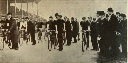
By 1898 the name above the door was the Electron Cycle company who manufactured bicycles. The name behind the branding was Horace L Murray-Shirreff. Along with his wife Mahala, the family came from Uxbridge where their son was born in 1896. They had moved to Lee Green by the spring of 1898 as his machines were twice ridden to victory at the Sportsbank Street Velodrome in Catford (pictured below) over the Easter Bank Holiday, once by Horace himself (3). Electron had moved on within the parade by 1911 as they were listed within the Clock House (see above) in the Kelly’s Directory. The sojourn at the Clock House was probably a short one as in the 1911 he’d moved to Staines and was listed as an inn keeper in the 1911 census.
By 1911 James Walton was trading at number 7 as a florist; he had had a business just around the corner in Eltham Road’s Eastbourne Terrace in previous censuses, listed variously as a florist and nurseryman. In 1911 he was there with his second wife, Harriet and three children, two of whom helped in the shop. James died in 1913 aged around 79, but the business stayed in the family initially in the name of Harriet running it as war broke out.
9 Burnt Ash Road
Number nine was a rarity in that throughout its life as a shop it was to stay in the same trade – a butchers, there were also only three different names over the window in its 65-year life. The first of these was the shortest lived, Colonial Meat Stores, who operated there in the mid-1890s, which seemed to be a single shop rather than any form of chain.
Frederick Head was there by the turn of the century and in 1901 was 47, he hailed from Christchurch in Surrey, and was there with his wife, Martha 47 and 5 children of mixture of ages who were all born in Kings Lynn there as was a servant employed by them. The two eldest sons were both helping in the shop. By 1911 the rest of the family had moved on, but Frederick and Martha were still running the business.
11 Burnt Ash Road
Like its next door neighbour at number 9, 11 was almost a single trade, a fishmonger, although there were a few more names over the window. The ‘almost’ is because the initial traders, Green and Co, started life as a fruiterer around 1896 but by 1900 was trading as a fishmonger. Perhaps they couldn’t cope with the competition from the already established M J Martin over the road who was a fruiterer and florist. There was though a lack of fishmonger though, on both sides of Burnt Ash Road, so Green and Co adapted to meet a gap in the market.
Who Green & Co were isn’t clear, certainly in 1901 the shop was managed by Surrey man E M Mankleton along his wife, mother, four children and a lodger who worked in the shop.
There was a new name over the window by 1911, Sparks Bros. In the census that year Frank Sparks was the fishmonger, the fishmonger’s wife was Sarah and Henry, the brother in the ‘Bros.’ were also there.
13 Burnt Ash Road
Hudson Brothers were a chain of provisions dealers, that existed from the 1870s, they were based in Ludgate Hill and had a dozen or so stores in and around central London, many close to stations. They also had a few in the then suburbs like Lee Green by the mid-1890s, where the shop opened around 1894. They were to remain on the parade until the early 1920s. They refurbished the shop in 1908 as the advert to the left shows (4).
This was another shop that started life as a draper’s shop, initially Thomas & Co from around 1896, but by the turn of the century W Sanders Pepper (40), along with his wife Ella (37) who both hailed from Northamptonshire, they had arrived via Battersea where two of their children born. A shop assistant and a servant were also part of the household in 1901.
Around the end of the first decade of the century the Peppers moved on, possibly struggling with competition from drapers shops opposite, in Eltham Road and further up the parade.
The new name at the front by 1911 was Ethel Higgins who was a confectioner; there had been one next door, but it had closed a year or two before. Ethel was a widow from Greenwich and lived there with her daughter. Whilst names changed periodically it was a business type that remained until the end of the parade, by 1916 Elizbeth Stevens was running the confectioner’s shop.
Around 1911 the shop front seems to have been ‘split’ and 15a appeared – the dyers and cleaners, Chambers and Co.
17 Burnt Ash Road
17 started its life as a shop around 1896 as a stationer’s run by Thomas James Watts; it wasn’t a business to last long though. By 1900 Annie Palmer had taken over the shop but changed the business to a confectioner, she was a widow who a decade before had been living in nearby Wantage Road. By 1905 her husband Samuel Evans Palmer was running the business, she died in 1908, and Samuel had gone by 1911 and was a Peckham based ‘Coffee House Keeper’ by then – whether this was a temperance one like one in Lee High Road isn’t clear.
By the census in 1911 Flora May Phillips, a tailoress from Bromley was there on her own, although the name over the window was Frederick May.
Like number 15, the arrival of a confectioner saw the shop split into two – dressmakers Mabel and Eleanor Harkness, there in 1900. Empty in 1905, Florence Wood, a milliner, was trading from there in 1911.
The first shop at 19 opened around 1896, a Wine and Spirit merchants run by Cockle & Sons. It didn’t last long and neither did the next tenant the Electron Cycle Co.; as we’ve seen Horace L Murray Shirreff’s business popped up in three locations on the parade in little more than a decade.
The next name over the window was that of Neal and Son, who were there by 1905. It was a trade that reflected the era, saddlers, and will have complemented William Brown’s corn dealers over the road who sold the feed for the horses. George Neal had been born in 1871 to a family in the same business and operated in Prospect Terrace next to the New Tiger’s Head, like William Sweet at 17a. George was in ‘Son’ in Sons. George was operating in Turner Road (now Dacre Park) in 1901 and moved back to Lee Green by 1911 where he was to continue at the southern end of the parade until around his death in 1921.
The parade will be returned to after World War One, when the second part of the story will take it to the stage that the bulldozers moved in ahead of the construction of the Leegate Centre.
The ‘story’ of the parade has been pieced together using Kelly’s Directories held by Southwark Archives – generally looking at every 5th year since the parade opened for business from 1896 along with census records before that.
Notes
Kentish Mercury 29 November 1907
Kentish Mercury 24 September 1897
West Middlesex Gazette 16 April 1898
Kentish Mercury 2 October 1908
Pictures and Other Credits
All the census and related data came via Find My Past (subscription required)
The Kelly’s Directory data was accessed via Southwark Archives
The black and white postcards and photographs of the parade are from the collection of Lewisham Archives, they are used with their permission and remain their copyright
The photograph of the Velodrome is via eBay in February 2016
The picture of the farm is from the information board at Lee Green
Beating the bounds is an ancient tradition, reminding parishioners of the importance of boundaries which was carried out during Rogationtide—the fifth week after Easter. There would be a walking of the parish boundaries, with children would carrying willow which would be used to beat the boundary markers. The boundary markers might be stones, streams or marks on trees, or roads. Oddly, other than around Lee Green, roads seem to have been neglected in deciding the parish boundaries of Lee.
No willow will be harmed in the perambulation of Lee, the on-ground research for which appropriately started on Rogation Sunday. The variant of Lee that we will be metaphorically beating is the civil parish mapped with the second edition of the Ordnance Survey 6” to the mile series. It was was surveyed in 1893 and published a few years later, just before Lee was merged with Lewisham to form the new Borough of Lewisham in 1900.
Lee in 1893 was a long narrow parish, a width of just over a mile and a quarter at its broadest point between Lee Bridge at the western end of Lee High Road to just beyond Cambridge Drive’s junction with Eltham Road. It’s length was around 5 miles at its longest – Blackheath, just to the north of the railway, in the north, to Marvels Wood on the borders of Mottingham to the south. The boundary was around 14 miles long, although with the diversions made to avoid trespass and Hot Fuzz style demolition of garden fences the actual 21st century trip around the borders of late 19th century Lee is somewhat longer….
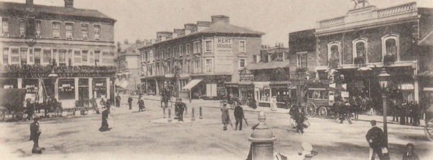
We start at Lee Green, one of the three original centres of Lee, along with Old Road and the top of Belmont Hill; it had the green that it’s name implies, along with a windmill and a farm. The boundary with Liberty of Kidbrooke was to the north east, beyond the Quaggy and with the Parish of Eltham in the north eastern quadrant of Lee Green and to the north of Eltham Road. In 1893, that quadrant included a previous incarnation of the New Tigers Head, then called the Tiger Tavern, the photograph below was taken around 1897.
The Old Tigers Head shown above was the 1896 variant; three years before, when the Ordnance Survey visited, it was the earlier building pictured below. It was about to be demolished with the pub briefly migrating a couple of doors down during the rebuilding.
On the Lee side, the farm, called Lee Green Farm, had been there in 1863 when the Ordnance Survey cartographers first mapped the area, but had been demolished soon after. The farm building had been relocated to the current site of Leybridge Court on the already built Leyland Road by 1893.
Opposite, the impressive Fire Station would still be 13 years away, and its predecessor on Lee High Road a couple of years off, it would be the temporary Old Tigers Head first.
The boundary followed the centre of Eltham Road; in 1893 there was a boundary post more or less next to the easternmost leg of Ravens Way, presumably named after the Ravensbourne Athletic, whose buildings were incorporated into the post war development, but had not been developed in 1893. In the first incarnation of the Ordnance Survey map, the Lee Green Toll Gate (pictured below) would have been a few metres behind, a bus stop is located in its place now. Tolls were meant to cover the costs of maintaining the roads, but with the coming of the railways (1849 in Lewisham and Blackheath) income dropped and in 1888 the remaining Turnpike Trusts were wound up with responsibilities going to the local authorities.
The current, and indeed 1893 surveyed boundary, goes to the rear of the houses in Cambridge Drive, following the edge of the Old Colfeans playing fields. Cambridge Drive, originally Road, and the land bordering Eltham Road had been one of the first parcels of land sold from Horn Park Farm for housing by the Crown Estate. The 1890s and current variants of the boundary slightly diverge around Dorville Road, briefly, home to Edith Nesbit. The former border slightly cut across the playing fields, but was presumably revised to ensure that the cricketing boundaries weren’t crossed by administrative ones.
The boundary, now with Greenwich (in 1863 with Eltham), re-emerges on Upwood Road. Former municipal generations needed to make boundary stones or even marks on trees to indicate the edge of their territory. Their modern counterparts have more subtle methods – different shades of tarmac, wheelie bins of changed hues and my favourite here, the humble street light. Lewisham has energy efficient, 21st century LED lights whereas the Royal Borough has a cornucopia of types including some rather attractive Borough of Woolwich concrete ones which probably dates from the 1950s.
The 1893 and current variants again diverge at this point, the former boundary heading south east, the current one turning back westwards behind elegant interwar detached houses of Upwood Road. The divergence seems to have been after the move of Colfe’s, then a Grammar School, in 1963. The original had been in a site between Lewisham Hill and Granville Park in Lewisham.
It had been largely demolished by a V-1 flying bomb in 1944 – the site is pictured above, and until the 1960s used what are now Brindishe Green and Trinity Primary schools in Beacon and Leahurst Roads respectively. The new school would have stood astride the then Woolwich and Lewisham boundary, so the current variant hugs the railway line heading towards Mottingham from Lee.
The boundary crosses the South Circular close to Alnwick Road where a pleasant Green is situated. The 1893 flâneur would have found the last large farm of Lee at the southern edge of the green on what is now Horncastle Road. Running Past has already told the story of Horn Park Farm; but there was a cautionary tale that is worth repeating in relation to boundaries.
Magistrates at the Green Man in Blackheath had to decide on the case of whether Lee or Eltham parishes should pay for the care of a farm worker at the farm. The boundary passed through the centre of the house on the farm he lived in. In fact, his bed was actually on the boundary – the magistrates found in favour of Lee as the farm labourer would have put his feet on the Eltham side first.
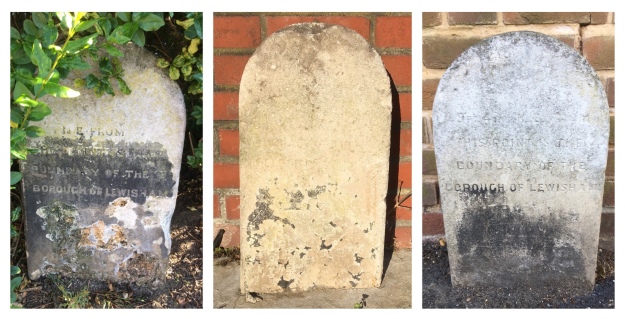
The development of Horncastle Road seemed to follow field boundaries, which also marked the administrative border. There were a couple of stones in 1893 that have been replaced by rear garden fences. As we saw in a post on Corona Road, the Crown Estate, had sold off land alongside Burnt Ash Hill, initially used as a brick works used by John Pound and then developed by William Winn. Almost all of Winn’s development has been lost to the Blitz and post war redevelopment.
The 1893 boundary bisected a tennis club within the development, but seems to have been adjusted soon after as there are a trio of very weathered 1903 boundary markers marking the current border between Lewisham and Greenwich on Corona Road at its junction with Guibal Road, on Guibal Road itself and at the junction of Guibal and Winn Roads.
While the derivation of Winn and Corona Road is clear, developer and relating to the Crown, Guibal isn’t immediately obvious. It isn’t a family name of either William Winn or his wife and the only obvious mentions in the press at the time relate to the development of a centrifugal mining fan by a French engineer, Théophile Guibal in 1872. It is not an obvious connection to an area with no mining heritage.
In the next post on ‘beating the bounds’ we will look at the boundary from Winn Road southwards towards Grove Park.
Picture Credits
The Ordnance Survey map is on a non-commercial licence from the National Library of Scotland, other maps from the same source have been referred to for the post;
The photographs of Lee Green and the Lee Green Toll Gate are from the collection of Lewisham Archives, remain their copyright and are used with their permission;
The photograph of the earlier version of the Old Tigers Head is from an information board at Lee Green; and
This, and the series of posts on the Lee boundary that will follow, would probably not have happened without Mike Horne, he was the go-to person on London’s boundary markers; he had catalogued almost all of them in a series of documents. He was always helpful, enthusiastic and patient. He died of a heart attack in March but would have loved my ‘find’ of a London County Council marker in some undergrowth on Blackheath during 2020’s lockdown, and would have patiently explained the details of several others he knew to me. A sad loss, there is a lovely series of tributes to him via this link.
It is easy to forget that Lee Green was once a village green – large enough for cricket matches – with a windmill and a village pub. Unsurprisingly, there were farms too – over time, the blog will probably cover most of the former farms in the area. The starting point though will be a farm next to the green – the imaginatively named Lee Green Farm.
The location of the farmhouse was roughly where the decaying remains of the Leegate Centre are now located. Its age is uncertain, oddly it wasn’t covered in Josephine Birchenough’s fascinating booklet ‘Some Lee Farms and Fields’. However, the information board at Lee Green suggest dates it around the mid to late 17th century, there were certainly buildings there in John Roque’s 1740s map (1).
The land was owned by the Crown, probably as part of the extensive lands held through Eltham Palace, and the first on-line reference to the farm was a lease granted to William Morris in 1838 of both Lee Green Farm and the neighbouring Horn Park Farm.
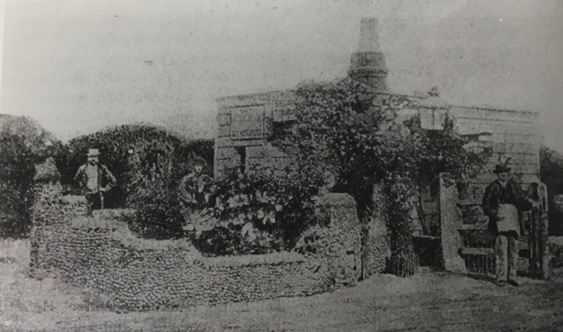
Lee Green Farm (see picture below (2)) was 131 acres in size, according to tithe records, and was a mixture of arable and pasture but it was just a small part of the land that William Morris (sometimes spelled Morriss) farmed. As early as 1815 he was leasing much of the current Cator Estate (3) and his 9th (ninth) child was born in Kidbrooke. The land was largely rich pasture that he used for dairy cattle – important in terms of proximity to London, prior to the development of the railways.
By the 1830s he had relinquished much of this Cator estate interest, Kidbrooke tithe records for 1850 had his interest at just 7 acres. Some of this was to allow development – such as a field where 97-115 Lee Road now stands (4).
The 1838 lease of Lee Green Farm was presumably a continuation of a previous one, certainly he was farming in Lee in 1820 as there was a case as the Old Bailey involving the theft of two cows and an attempt to sell them to a farmer in Mile End – William Smith was found guilty and hanged. The timings of his move to Lee are confirmed with the birth of his 11th child there the same year.
What is clear though is that William Morris had interest in a lot of land around Lee Green other than the Farm, F H Hart noted that at this time he and ‘Farmer Giles’ from Burnt Ash Farm leased most of the land in the area. Morris’ land included
Around 4 acres in a field called Crab Croft, which seemed to be in the area of Marvels Lane in Grove Park (5)
William Morris(or Morriss, the spelling of the surname varies) was from Banstead, Surrey was the son of Samuel and Sophia Morriss, and was baptised on May 29 1780. By 1804 he had married Elizabeth Walker and they had their first child Sophia and they were living on Blackheath Hill – presumably close to the Green Man Hotel. At that stage he was described as a ‘milkman’ or ‘cowkeeper’ – possibly having a small amount of land (as was the case with Clark’s of Summerfield Street).
Elizabeth died in 1829 and was buried in the old St Margaret Lee Churchyard (see middle vault above). William Morris remarried in early 1832, Susannah gave birth to the first of six children for the new family at Horn Park and seem to have made that their home rather than Lee Green – their youngest child was baptised in Eltham, rather than St Margaret’s Lee.
The farm buildings moved slightly to the east in the 1840s to what was to become known as Tudor House (roughly where the Leybridge Court estate is now). This was presumably under the stewardship of Morris, who also built a few speculative homes adjacent to it (6).
One of the frustrating elements of writing this and other posts about the history of the area is that written history tends to focus on the rich and influential in society. Nothing is known about the farm labourers on Morris’ land, other than there were a number of tied cottages, whether Morris was a good employer, his rates of pay and so on. The only references to the rural working classes in Lee tend to relate to crime, and as we have seen with the case of the theft of cattle in 1820 and its draconian punishment, and when there were calls on poor law relief – such as in the bitterly cold winter of 1814 – referred to in the post on Benjamin Aislabie.
There were some attempts to redress this by William Cobbett in the 1820s. Cobbett was a late Georgian and early Victorian radical, the son of an agricultural labourer from Surrey, he opposed to the Corn Laws who undertook a series of ‘Rural Rides’ to look at the condition of farming in the 1820s. In addition to the Corn Laws, his ‘rides’ were against a backdrop of the Enclosure Acts of the early part of the century, where the rich landowners took ownership of what hitherto had been common land. While there seems to have been little common land in Lee, the Acts had a major impact elsewhere in Lewisham – particularly in Sydenham.
Cobbett visited farms, talked to farmers and labourers on his horseback rides; he did not visit Lee, so it is difficult to judge on conditions locally but he did note in terms of land close to Dartford “Here dwell vanity and poverty.”
It is certainly difficult to generalise based on Cobbett’s observations and whether there was this “poverty” in Lee is unclear but elsewhere in the south-east when describing farming poverty he noted that
The labourers seem miserably poor. Their dwellings are little better than pig-beds, and their looks indicate that their food is not nearly equal to that of a pig. Their wretched hovels are stuck upon little bits of ground on the road side, where the space has been wider than the road demanded.
We will return to William Morris in his final days at College Farm where he was to pass away in 1851, by then Lee Green Farm was being run by his son Richard, three of his sisters Eleanor, Rebecca and Mary were living there too – the farm was listed as 302 acres and employed 20. Richard was still at the farm in 1861 although the acreage was much reduced, just 114 acres were being farmed. He moved to Days Lane Farm in Blackfen around 1868 (see comment below), he clearly had some interest in land in Lee after he left as he was on Electoral REgisters into the 1870s. Beyond 1861 there seem to be no mentions of the farm, through on-line sources at least, – maybe it became unviable as land was lost to development.
The original site of the farm was redeveloped in the 1860s as housing called Carston Mews, although the name lived on it Carston Close, just to the south. Carston Mews itself was demolished to make way for Leegate shopping centre in the 1960s. The centre has been in decline since Sainsbury’s opened to the west of Burnt Ash Road, something compounded by an increasing amount of empty office space above the centre. There are plans to redevelop the centre going through the planning process at the time of writing (January 2016).
Notes
Map from information board at Lee Green
ibid
Neil Rhind p34
ibid p162
Josephine Birchenough with John King (1981) Some Farms and Fields in Lee p28
I am indebted to Mike for providing most of the family information via a fascinating comment (see below, you may need to click on the title first if you can see another post below this one) – the post was substantially updated in June 2016 as a result of this.


