Tag Archives: Hedgley Street

War and a Lee Street – Taunton Road

Over the years Running Past has looked at the impact of the Blitz and the V-1 and V-2 attacks at the end of World War Two, as well as looking at the preparations that were made ahead of war being declared.  This post takes a slightly different tack, looking at one street and the impact that was felt there – Taunton Road, a street of mainly Victorian terraced houses running from Burnt Ash Road to Manor Lane.

In the main we’ll look at World War Two, but we’ll start with World War One; like virtually every other street there were young men who went to war from Lee but who never returned….

Frank Eugene Gamblin was just 19 when he died on 31 May 1918 in Northern France.  He was the son of Thomas and Edith Gamblin of 50 Taunton Road (at the corner of Hedgley Street).  He was a Private in the Devonshire Regiment.  Frank had been working part time as a ‘Milk Boy’ aged 12 in 1911, still at school and living in Rhyme Road in Lewisham.

Just beyond the school, at 58 Taunton Road, lived William Jupp; he had been born in Lee, although the family have moved to Hove for a while but was in the street by the 1911 census. At that point he was still at school, but just over seven years later, on 24 August 1918, he died near Albert in Northern France, aged just 21, a rifleman in the London Regiment.  His parents, Rachael and William, were still living in Taunton Road.

James Woodnott was a Private in the London Regiment who died at Aubers Ridge on 4 October 1918 in Northern France and was buried close by.  Born in 1886 he was the oldest of the five who died. He had grown up in Dacre Street; by 1909 he had married Fanny, and in 1911 he was working as a carman living in Neuchatel Road in Catford.  They were living at 83 Taunton Road, opposite the park entrance, as war broke out with two children, born in 1913 and 1914.

Another man with links to the street was Alfred Edward (Edwin) Braine. He had a couple of rooms at number 13 before he went to war. Born around 1881, he seems to have lived on the street for much of his life – growing up at 37. He was serving as a Sergeant in the Royal Field Artillery when he died towards the end of on the war on 20 September 1918 and is buried or commemorated at the Vis-en-Artois Memorial. He may well have joined the Army at 18, someone of a similar name (the middle name is listed as Edwin) and age signed up in October 1899 in the same regiment.

Charles Frederick Broad had grown up in Taunton Road, born around 1896 his parents, Rose and Huntley, were living at 84 Taunton Road by 1901.  He was still at school in 1911 but died less than six years later aged just 20 in Belgium on New Year’s Day 1917 where he was buried at Spoilbank Cemetery (pictured below).  He was a Lance Corporal in the London Regiment.  His parents were Huntley Charles Broad and Rose Matilda Broad still of 84 Taunton Road.

Entrance stone for Spoilbank cemetery

Two doors away at 80, was the mother of Ernest E Jackson; he was a Corporal in the Royal Fusiliers and died at Gallipoli on 13 August 1915, aged 22.  He may have no direct contact to Lee other than through her – Mrs Florence Brosinovich, who had married Henry in 1893.  Ernest was almost certainly born Brosinovich.

For reasons that will become clear, we will continue with the group of houses to the west of the park entrance where the Brosinovich and Broad households lived.  Unlike the bigger houses in the streets to the south, that part of Taunton Road hadn’t changed that much between 1911 and the outbreak of World War Two, it was still predominantly single-family homes, mainly housing skilled working-class households, when the 1939 Register was collected.

Florence Brosinovich and some of her family were still at 80, they shared with another couple. 80 was the only shared house in the group, two households with 5 people and all but Florence worked. 

The Broads were still at 84, Charles’ younger brother was working as a local government officer and his father in his 60s was working as a printer.  Their neighbours at 86 were the Buttons where Robert worked as a lorry driver and got the ‘heavy work’ supplement which would have entitled him to larger rations.  On the other side at 82 were three women sharing, including typist Doreen Tew, who would have turned 19 in the autumn of 1939.

Others in the group of houses to the west of the park included Amos and Elizbeth Howick at 70 who were in their 60s, he was a bricklayer and he too would have been entitled to the ‘Heavy Work’ supplement in the rations.  The Wilsons at 74, included paper hanger Henry in his early 50s, his work wouldn’t have got the supplement.

A little further down the street was Hedgley Street School (now Trinity), which is pictured above; there is a separate post on this but just before the 1939 Register was collated most of the children would have been evacuated to Ashford in Kent.  Although given it was another year until the start of the Blitz, many children will have drifted back to Taunton Road and neighbouring streets by the time bombing started.

As the children moved out, the Air Raid Precautions (ARP) service moved in.  Their role has been explored in an earlier post but one of the but several of the Noble family from 49 Lampmead Road were to be based there.  This included Phyllis (later Willmott) and her brother Joe who was injured when school bombed and seriously damaged with the front part largely destroyed in 1941 – the school never re-assembled.

Oddly the Nobles were to move to the house next door to the school (52) which had a yard (now part of the school playground) for Phyllis father’s building business – a trade that would have been kept very busy with repairing local bomb damage.

One of the earliest bombs to hit the street was on 25 September 1940 when an Anderson shelter in the garden of number 1, a small house on the opposite side to Sainsburys, took a direct hit – Charles (who worked at RAF Kidbrooke) and Claire Rivers both died, along with their 7-year-old daughter Sylvia – orphaning several other children.  There were 11 there in October 1939, including five who were redacted presumably children who weren’t evacuated. One of the surviving children, Ruby, ended up in an orphanage but was discovered by a brother were returned to Lewisham on leave and reunited her with other family members.

The deaths at number one weren’t the first from the street during World War Two though.  Sylvia Wickens from number 7 had volunteered to be an ARP Warden, she was based in Lewisham Town Centre and was one of 41 who died at Albion Way on 11 September 1940, when a public shelter took a direct hit. 

Almost four years later another resident of the street died in an attack on Lewisham town centre – Maude Clarke from 85 died in the High Street V-1 attack in July 1944.

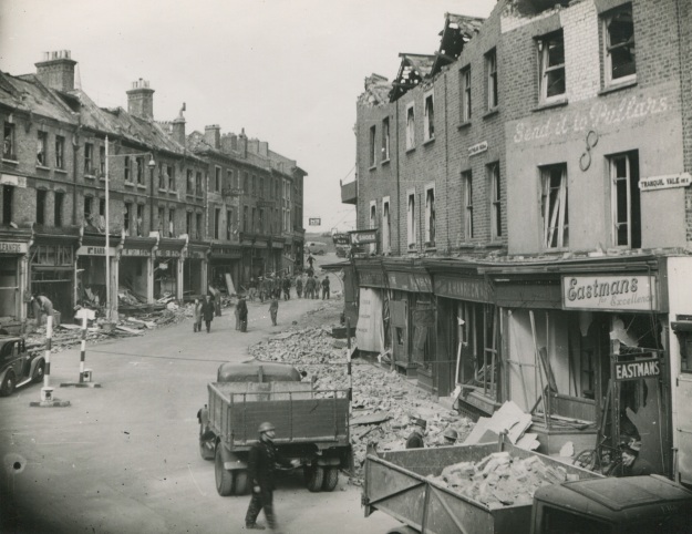
Returning to the Taunton Road, the most damaging raid was just before Christmas in 1940, when the section of the street that we covered above in relation to the 1939 Register was hit by a High Explosive bomb on 15 December.  82 probably took a direct hit as there was most damage there, but several other houses were destroyed beyond repair and replaced after the war with council homes.
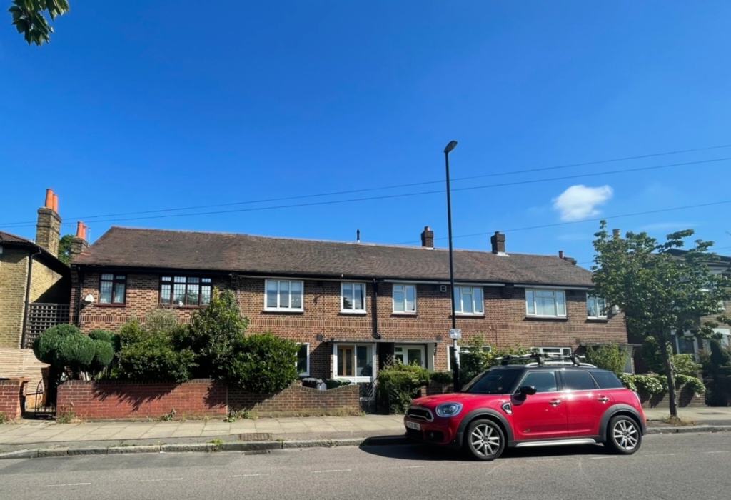
At 82 there were two deaths – one was the 23-year-old Monica Tew, who was listed as the daughter of H Tew. It may be remembered that Monica’s sister, Doreen was living there in 1939, the Tews may be have been displaced by earlier raids elsewhere.

82 was a shared house by 1940, also there were the Setons whose 7-year-old daughter Elizabeth also perished.  She had probably been originally been evacuated (see above) but had later returned to Lewisham.

Assuming that Florence Brosinovich had remained at 80 in the year since the 1939 Register was collected, she would have been made homeless – it seems that she moved to somewhere in the Reigate, Godstone, Dorking and Epsom area of Surrey where she died before the war was out in 1943.

There were other bombings on the street – lots of incendiary bombs fell around the junction with Wantage Road on 8 December 1940, not obviously causing any significant damage.  At some stage houses closer to the now Sainsburys site were destroyed, although this was either missed when I went through the ARP logs or wasn’t recorded, not every incident was on busy nights. 

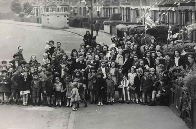
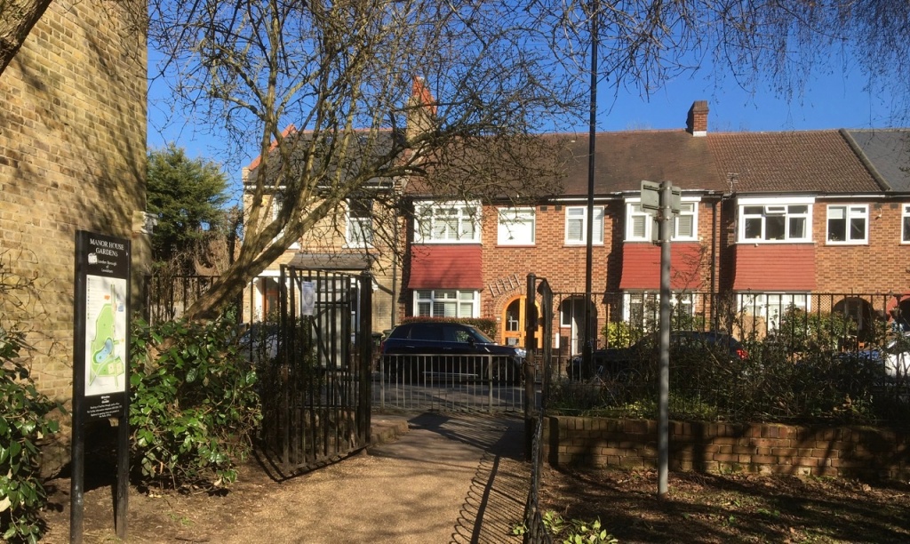
At the end of the War, on VE Day there were celebrations of the end of the war, no doubt they were tempered by the deaths and injuries to friends and neighbours.  There was certainly a party on Taunton Road, possibly two.  The photograph above is taken from around the park entrance looking back towards Wantage Road – there is a concrete air raid shelter in the background.  The one below is in the section close to Burnt Ash Road that was redeveloped 20 years or so later. 

Notes & Credits

  • The photograph of Spoilbank Cemetery is via Wikipedia on a Creative Commons
  • Thank you to David Carter for the information about his family who were orphaned in September 1940 link here
  • The photographs of VE parties are from the collection of Lewisham Archives, they are used with permission but remain their copyright
  • The photograph of Hedgely Street School is from a booklet produced by Church of the Good Shepherd, Lee in 1956, p15 – it remains their copyright and was accessed via Lewisham Archives and was used with the permission of both
  • The census and related data comes via Find My Past (subscription required)
  • The World War One casualties come from the Commonwealth War Graves Commission website
  • Most of the detail of the bombing raids come via the ARP Log for Lewisham which is held by Lewisham Archives
  • Thank you to Denise Whibley Baba on Facebook for details of Alfred Edward (Edwin) Braine.

Brightfield Road – the Street with Two Names, Part 2

In the first part of this post, we explored the 19th century history of Brightfield Road from its building as Robertson Street to its extension and renaming in the 1880s. We turn now to the 20th century and beyond, looking in particular at how the street fared in the World Wars.

We pick up the story with the 1901 census; the street had changed in the late Victorian period from homes for the building trades employed by John Pound, and other local builders, as well as for servants for the large houses in Lee, to a wider mixture of working class occupations.  Looking at the lower numbers at the eastern end of the street, little had changed by 1901 with a mixture of working class jobs such as road mender, carpenter, horse keeper and coachman (this excludes the shops which we will return to in a later post).

The average size of households had reduced to 5.3 (from 5.8 a decade before) mainly as a result of slightly fewer households taking in lodgers and/or houses being split between households. This was much smaller than the numbers in the not dissimilar homes in Ardmere Road in Hither Green which were built at around the same time.

There was little change by 1911, although the average household size dropped again to 4.5.  The nature of the jobs was little different though – manual trades and still lots relating to horse based transport.

The street fared badly in World War One, many of the sons, brothers and husbands of the households were either volunteers or conscripts to fight on the battlefields of France and Belgium – eight of them never returned home to Lee all were buried in cemeteries or remembered on memorials close to where they died.

  • William Upton of number 42 was a Driver in the Royal Engineers and died on 13 March 1918. He was a labourer in civvy street and was around 25 when he died; he was buried at Sailly-Labourse Cemetery in France.
  • Sidney George Munday lived five doors up from William Upton at 52, he was a Private with The Buffs (East Kent Regiment). He was 21 when he died on 14 April 1918 and is remembered at the Tyne Cot Memorial in Belgium.
  • William Henry Church had lived just over the road at 33, he was just 20 when he died serving as a Private in the Queen’s Own (Royal West Kent Regiment) on 18 September 1916.  He was buried at Etaples Military Cemetery in northern France.
  • Willie J Church was just 18 when he died on 6 June 1918, serving as a  Private in the London Regiment.  He is buried at Bienvillers Military Cemetery in France.  He lived at number 85, it isn’t clear whether he was related to William Henry Church.
  • Arthur John Cobb will have known Willie, as he lived  two doors away at 89 with his wife Gertie.  They served in the same Regiment too.  Arthur died on 18 February 1917 and was buried in France at  Merville Communal Cemetery Extension.
  • Alfred William Meggs lived seven doors down at 75, he was 20 and serving as a Corporal with the Queen’s Own (Royal West Kent Regiment) when he died on 3 October 1916.  He is remembered at the Thiepval Memorial, pictured above.
  • William George Bickle had lived five doors away at 65, he died two days after Christmas in 1915 aged just 16, the youngest on the street to perish. He shouldn’t have been there but, probably like Willie Church he will have lied about his age – soldiers needed to be 18 to sign up and 19 to be sent abroad as we saw with Herbert Burden from Catford who was shot for desertion aged just 17.

As World War Two broke out, the numbers living in the smaller houses at the eastern end of Brightfield Road were probably the lowest that there had ever been in the street’s existence – an average of just 2.9 people per home.  A large chunk of this related to the evacuation of children in September 1939, just before the ‘census’ for rationing purposes was taken, the 1939 Register.  However, even taking this into account household size had reduced with very few lodgers and a lot more houses just inhabited by couples and single people.  This will probably be at least in part as a result of limited non-contributory pensions being paid from 1909.

Since 1911 all the horse related trades had disappeared and the eastern end of the street was home to several involved in train, lorry and tram related transport.  There were several working at the Royal Arsenal making armaments.  Very few had the ‘Heavy Work’ suffix to their role which would have allowed them to have larger rations though.  The difference with Ardmere Road here is significant.   A slightly smaller proportion of women worked to 28 years before in 1911, but the trades were little more diverse – still mainly shop, laundry and work and dressmaking though.

There were a couple of nights heavy bombing in early December 1940, on the nights of the 8th and 9th of December.  Given the significance of these nights in the area we’ll return at some point but several houses had incendiary bombs hit them – 19, 20, 22, 43, 46, 52, 60, 113 and 123.  All seemed to have been put out and the houses remain.   There was a high explosive bomb that seems to have landed in the rear garden of 95 without causing too much damage.

Just after Christmas incendiary bombs rained down on Brightfield Road with 32, 34, 42, 43, 49, 63 and 83 all hit by them (some are pictured below) – the fires were put out by wardens and the inhabitants, but many of the roofs were damaged.

Early in 1941 there was a high explosive bomb that hit the roadway close to the bridge over the Quaggy, several houses were destroyed or had to be demolished due to the resulting major gas explosion (1). The damage is the darker colours is shown on the bottom left hand corner of the map below (2). No one died with only two requiring optional treatment but there was widespread damage in terms of broken windows and major structural damage to houses up to 100 metres away (3).

On the odd side, 103 – 107 were never replaced and the gap was used to form an entrance to Manor House Gardens.  Over the road, whilst the last house, 92 (at the left of the photograph) survived, 84 to 90 didn’t and they were replaced by private sector housing after the war.

Over the bridge, 75 to 79 were lost too at some stage in the Blitz.  They too weren’t replaced – the playground to what was then Hedgley Street School (now Holy Trinity School) was extended.

Several civilians on the street died;

  • Annie Taylor from 121 Brightfield  died in an attack on 110 Springbank Road as we saw in a post on that street;
  • Alfred Dibley of 56 died on 5 July 1944 at St John’s Hospital on Morden Hill presumably as a result of a V-1 attack;
  • Elizabeth Grant of 70 died at Albion Way Shelter early in the Blitz and
  • Eliza Jenner was injured at an attack on number 4 on 11 May 1941 and died at Lewisham Hospital the same day.  

There was a VE Day party there, a bit later than most on 2 June 1945.  The street scene is now markedly different – the attractive bank buildings (once a temperance coffee house) and the three storey shops at the end of the street were lost after the war either to Penfold’s or Sainsbury’s expansion.  We’ll return to the shops in a later post.

So who lives there now?  While it isn’t possible to use census data from 2011 just for the street there is a Output Area that relates to most of the street, along with Lampmead Road.  The employment categories are very different to the census data that we have looked at before.  The main employment types of the 196 residents in employment were shops (7%), finance, insurance and banking (10%), professional and scientific (13%), education (19%) and health (7%).  It will be interesting to see what changes there are when the 2021 Census results are collated.

Most of the homes seem to be owner occupied homes – although there are eight or nine owned by property companies letting the homes and three are let by social landlords.  The change is massive compared with when the homes were built as Robertson Street when virtually all will have been privately rented.

Certainly rising house prices will make affordability nigh on impossible for the sort of people that lived there before World War Two. One of the bigger houses was sold for £842,500 in 2020 – now single-family dwellings, when built they had been ‘conveniently arranged for two families. Let to very respectable tenants at 12/- a week’ in 1892 (4). 

One of the smaller houses sold for just under £500,000 just before the first lockdown.

We will return to Brightfield Road at some point in the future to look at the shops that used to be on the street.

Notes

  1. Phyllis Willmott (1988) Coming of Age in Wartime London, Peter Owen p51
  2. Laurence Ward (2015) The London County Council Bomb Damage Maps 1939-1945 p116
  3. Willmott op cit p51
  4. Kentish Mercury 25 July 1892

Credits

  • Permission has been given by the copyright owners of the Bomb Damage Maps, the London Metropolitan Archives to use the image here, it reamins their copyright
  • All the census and related data came via Find My Past (subscription required)
  • The photographs of the VE Day party is part of the collection of the Lewisham Archives, it is used with their permission and remains their copyright;
  • The photograph of the Theipval Memorial is on a creative commons via Wikipedia

Brightfield Road – the Street with Two Names (Part 1)

Streets having their names changed is nothing unusual – we’ve covered it a couple of times before with Dermody Road (formerly Hocum Pocum Lane), Waite Davies Road (formerly (Butterfield Street). Similarly, on the other side of Lee High Road the bottom of Dacre Park was previously known as Turner Road. Like the second two examples, there is fading evidence of a painted street sign bearing the earlier name. However, it isn’t as easy to decipher the former name, Robertson Street, due to multiple layers of faint paint, re-pointing and a burglar alarm. In a pair of blog posts we’ll tell the history of the street – from its building to the present day.

The builder of the original part was someone we’ve covered several times before, John Pound, mainly in relation to his house building but also shops on Burnt Ash Road, pubs and Lee Public Halls. The street was built by Pound around 1862 (1), with applications made to the Board of Works that March for drainage connections. The land was owned by Lord Northbrook, although it doesn’t seem to have been farmed as part of Lee Manor Farm – it isn’t in the farm map of 1846 – and the estate seems to have retained the freehold post development (2) as permission was sought from Lord Northbrook’s agent for some work.

The homes were unlike most of those in the rest of the area at the time. The arrival of the railway in Blackheath had seen substantial homes with space for servants built to the north of Lee High Road. The function of these smaller houses was similar to those in Lee New Town – providing homes for the servants who didn’t ‘live-in’ and working classes of mid-Victorian Lee. There was another function too, large-scale housing development in what was then suburbia needed somewhere for the building labourers and trades to live in an era without cheap public transport. Pound seems to have done the same around Waite Davies Road and Summerfield Street for his brickworks in South Lee. It was a pattern followed by Cameron Corbett with houses in Sandhurst Road a few decades later.

Pound also seems to have built the neighbouring Hedgely Street – he made an application for sewer connections in 1868 (3).  The street was adopted and paved in 1871 at a cost of 4/6d on the rates for occupiers – not the landlord (4).

So, who were the early occupants?  We’ll look at the first 20 houses in the 1871 census, the first census they appeared in; while the numbers appeared as consecutive in the census reports it isn’t clear whether this was the case on the ground.  The numbering is now odds and evens. The shops have been ignored for now, but may be returned to in a later post.

The majority (52%) of heads of household were working in the building trade, mainly skilled trades with the remainder split between various forms of domestic service and other trades.  Relatively few of the women worked, but those who did, tended to be listed in the census as charwoman or laundress.  While not in in the houses reviewed in detail, elsewhere in the street there were farm labourers housed – presumably still working at either Burnt Ash, Lee Manor or Horn Park which were all still working at that stage.

Almost half of the houses were either home to two households or took in a lodger, there were some very overcrowded homes as a result – 13 lived at no 17 for example. Almost all the households had children.

A decade later the average number in each house was 6.7 (it had been 5.5 in 1871), mainly due to an increase in lodgers and shared houses.  More women were working, although the trades were mainly around washing, ironing and cleaning.  Male employment had changed little too, the majority working in the building trades.

Unsurprisingly, there was some crime relating to the street, a fair amount of it alcohol related. John Mahoney had to be removed by heavies from the Tiger’s Head for being drunk and aggressive. He then went over the road to what is now referred to as the New Tiger’s Head, but press reports called the Little Tiger, where he was arrested after falling asleep drunk. He then violently assaulted the arresting officer for which he spent 6 weeks in prison (5).

Robert Stow was found guilty of assaulting a police officer after being arrested for being drunk and disorderly outside the nearby Duke of Edinburgh – his defence was that he didn’t know it was a policeman and that he’d had too much rum to drink cut no ice with the magistrates.  He was fined 20/- or 2 weeks in prison (6).

Theft wasn’t completely absent though – Thomas Upton (23) a labourer from 19 Robertson Street charged with stealing 25 hens from Blackheath Park and then selling them in Greenwich.  He was sent to prison for 14 days (7).

The western side of the terrace backed not onto the Quaggy, as it does now, but onto a path from that broadly followed what is now Aislibie Road.  After the floods in 1878 and probably also to allow better development of the land that was to form Lampmead Road, the Quaggy was deepened, straightened and took the route of the path. The differences are clear between the 1863 (top map below) and 1893 visits of the Ordnance Survey Cartographers.

The extension of the street to the northern side of the Quaggy seems to have happened around 1885 following the piecemeal sale of the Lee House estate. The builder may well have been George Mitchell; he made the application for connecting the new homes Brightfield Road to the existing sewers in what was still referred to as Robertson Street. John Pound asked for money for the connection (8). It is assumed that these would be the homes that are now numbered 109 to 127 Brightfield Road (some of which are pictured below), but could have been those to the south over the Quaggy.

Three years later a decision was made by the Metropolitan Board of Works in March 1888 to change street names in the area.  It seems that Lampmead Road was created, it had originally been a dog-leg of Lenham Road going towards Lee High Road.  The biggest change was in relation to Brightfield Road – from 1883 it had run from Old Road and then dog-legged around to the new homes built by George Mitchell.  The section from Old Road now became Aislibie Road and Brightfield Road, while shortened to the north took expanded over the river and Robertson Street was no more (9). In addition to the remains of the painted sign, a stone one remains and is now part of a garden wall.

The new Brightfield Road had changed a lot by 1891 compared with the last census for Robertson Street. John Pound’s building work had finished in the area and only 8% of the heads of household at the eastern end of the street were working in the building industry, just over a third were servants – mainly jobs relating to horses with the remainder a wide variety of manual jobs. As was the case a decade earlier a lot of the women worked – mainly as dressmakers and laundresses. Most households had children and most of the houses were either shared or homes to lodgers too – overcrowding remained, although it was less bad than in 1881 – the average was 5.8 rather than 6.7 a decade earlier.

There were a few sales of the houses which seemed to be all tenanted over the next few years. In 1892, 111 -125 (odds) were up for sale at auction. These are the larger houses backing on to Manor House Gardens, then let as a military crammer school before the House and Gardens were sold to the London County Council in 1898. The particulars of the sale of the houses in Brightfield Road noted the proximity to Lee and Blackheath stations. Each house was ‘conveniently arranged for two families. Let to very respectable tenants at 12/- a week.’ There were unexpired leases of 92 years (10).

Three years later some more of the later houses, 75-79 which were adjacent to the original houses were sold – they were advertised as being on long leases, having a weekly rent of 12/- and an annual ground rent of £5 (11).

The change in name didn’t stop crime relating to the street in 1897, Emma Agate was arrested for theft of a large number of garments from Lee Public Halls Steam Laundry (in early 2021 home to Travis Perkins off Holme Lacey Road) where she worked as an ironer, she was found with a number of pawn tickets. She denied the charges but was remanded in custody (12).

There were a couple of bigamy cases – William James was charged with bigamously marrying Mary Bator of number 61 in 1889 (13). Four years later, Walter Garland admitted to a bigamous marriage to Alexandra Taylor of 60 Brightfield Road (14).

We’ll leave Brightfield Road at the end of the 19th century, returning in the second part to cover the 20th century and beyond.

Notes

  1. Kentish Mercury 22 March1862
  2. Kentish Independent 01 June 1872
  3. Kentish Independent 10 October 1868
  4. Kentish Independent 16 December 1871
  5. Kentish Mercury 18 June 1870
  6. Kentish Mercury 30 October 1875
  7. Kentish Independent 10 April 1886
  8. Kentish Independent 02 May 1885
  9. Kentish Mercury 9 March 1888
  10. Kentish Mercury 25 July 1892
  11. Kentish Mercury 29 September 1895
  12. Woolwich Gazette 27 August 1897
  13. Kentish Mercury 13 June 1890
  14. Woolwich Gazette 27 April 1894

Credits

  • The maps are on a Non-Commercial Licence via the National Library of Scotland
  • All the census and related data came via Find My Past (subscription required)
  • The photo of the stone sign is courtesy of Frederic Heffer

Preparations for World War Two – ARP Wardens, Sirens and Black Outs

As part of the 80th anniversary of World War 2 breaking out, Running Past has been looking at some of the preparations for war on the ‘Home Front.’ So far, this has included Lewisham children being evacuated to Kent then Surrey and the variety of shelters used to one of the key elements try to keep the civilian population safe during air raids. We return now to the Civil Defence services set up to try to keep the civilian population that remained in London and other urban centres as safe as possible from the air attacks that were expected soon after war broke out.  This post looks in particular the ARP (Air Raid Precautions) service.

Like the building of shelters, the roots go back to the interwar period. The ARP Department of the Home Office was set up in 1935 (1),  although appeals for volunteers were not made until 1937 – the approach was based on studying the impact of fascist bombing of Republican areas of Spain and the measures that were employed on the ground there (2). A second appeal for volunteers was made in March 1938 (3).

In the months before war broke out, it was agreed to pay full time ARP personnel £3 per week, although only £2 for women, with recruitment posters stressing the desire for ‘responsible men.’ Later in the year payments for some part time personnel were agreed (4).

Some of the early work that ARP wardens had to contend with was enforcing the blackout that was introduced on 1 September 1939 and lasted until April 1945 (5). Shop windows were darkened from 6:00 pm as were houses – requiring heavy curtains or blankets to ensure that no light escaped. Streets in almost darkness were dangerous with a large increase in injuries – 20% of the population reported as having suffered blackout related injuries in the first 4 months that they were in operation.

Road deaths increased around 40% when compared with pre-war fatalities. Regular readers will recall that a few years earlier Lewisham streets were noted as being some of the most dangerous in London.

Source ebay March 2016

Their control centre was in the basement of the old Town Hall in Catford (above) and, after January 1940, was funded through the rates, a predecessor of Council Tax (6). Every bombing, incendiary and related incident was phoned through to the ARP control centre who effectively acted as an emergency call centre.  They would find out about injuries, deaths, those trapped or missing, any fires that couldn’t be controlled locally (7) and look to send emergency services to assist.  On nights where there was heavy bombardment or large numbers of incendiary devices dropped these were not always available, as we saw with the fire that destroyed the original Church of the Good Shepherd in Lee, below.

Below is one small part of the Lewisham ARP log for the period between Christmas and New Year in 1940, while there had been a lull on Christmas Day and Boxing Day, hundreds of high explosives and incendiary bombs were dropped over the next few days, many around Lee. We’ll explore these attacks in much more detail in later posts.

At the level below the control centre, Individual wardens were based at schools and some purpose built concrete ‘pillboxes’ (8) around the community. They each served a population of 2 to 3,000, typically with a complement of six wardens, mainly part time (9).

One of the ARP posts in Lee was at what was then Hedgley Street School, pictured above (it was later Northbrook and currently Trinity Lewisham School) on the corner of Taunton Road. Running Past has covered the Noble family, who started the war at 49 Lampmead Road, a number of times before, including in relation to 1920’s play and the ‘Sunday Constitutional.’ Several of the family members worked for the ARP – Phyllis was briefly a warden with a navy battledress and steel helmet with a large white ‘W’ on the front (10). Her brother Joe and a cousin, who also lived at 49 Lampmead Road, worked as messengers based at the School – while in theory there were telephone links to Catford, cycle and motor cycle based messengers were used too in case lines came down.

The school was hit while Phyllis’ younger brother, Joe, was working there and partially destroyed. He was to be the only one injured – a bruised ankle from a falling fireplace (11). The ARP post presumably moved to an undamaged part of the evacuated school.

On the ground, the local ARP wardens would deal with whatever was needed, this ranged from providing first aid to those injured in incidents, directing people to shelters and help in getting the dead and injured out of bombed premises, this was both for hits on houses as well as the larger scale destruction of incidents like the attack on Sandhurst Road School in early 1943.

In front of St Stephens Church in Lewisham is a tall metal post with what looks like a pair of speakers attached to the top. It is easy to miss, particularly when the adjacent trees alongside the Quaggy are in leaf. It seems to be Lewisham’s last remaining air raid warning siren – one of around 25 around the then Boroughs of Deptford and Lewisham (12).

Once the warning sounded ARP wardens ensured that residents took cover in one of the air raid shelters; they sounded on over 1200 occasions during the war. Other locations seem to have included a former police station on Catford Hill, Catford Police Station on Bromley Road and Sandhurst Road School. The survival of the Lewisham one probably relates to its location next to the Quaggy and has a residual use as a flood warning siren.

The chilling sound of the air raid warning siren and, at the end, the all clear sound is on the YouTube video.

Finally, it is worth remembering that many ARP wardens lost their lives during the war; across London around 300 perished (13).  Those that died serving their community in Lewisham included (14):

  • Albert Brown (64) of 1 Eliot Hill was Injured at 14 Montpelier Vale on 8 March 1945 in the aftermath of the V-2 attack on Blackheath and died later the same day at Lewisham Hospital (pictured below);
  • Henry Cottell (52) was a Senior Air Raid Warden of 41 Manor Lane Terrace was injured at Lee High Road on 29/12/1940 and died same day at Lewisham Hospital;
  • Barbara Fleming (16) of 20 Farmfield Road in Bellingham was injured on 16/04/1941 at Warden’s Post, Ashgrove Road; died same day at Lewisham Hospital;
  •  Douglas Hardisty (44) ; of 70 Vancouver Road in Forest Hill who was a Captain in the  Home Guard as well as being an ARP Warden was Injured 21 March 1944, at corner of Vancouver Road and Kilmorie Road; he died at Lewisham Hospital;
  • Kenneth Smith (33) of 251 Burnt Ash Hill was injured at Methodist Chapel, Burnt Ash Hill on 13/10/1940 and died same day at Lewisham Hospital; and
  • Marjorie Wickens (19) of 7 Taunton Road died at the Albion Way Shelter on 11 September 1940.


Running Past will return to the fire watchers, the expanded fire service and other elements of the in later posts on World War Two.

Notes

  1. Mike Brown (1999) Put That Light Out! Britain’s Civil Defence Services at War 1939-45 -Stroud, Sutton Publishing p2
  2. ibid p3
  3. ibid p5
  4. ibid p7
  5. Lewis Blake (1995) How We Went To War – Deptford & Lewisham 1939 – 1945 p12
  6. ibid p28
  7. ibid p28
  8. ibid p27
  9. ibid p27
  10. Phyllis Willmott (1988) Coming Of Age in Wartime – London, Peter Owen, p42
  11. ibid p45
  12. Blake, op cit, p41
  13. ibid p29
  14. These are based on records from the Commonwealth War Graves Commission website

Picture Credits

  • The recruitment poster comes from the collection of the Imperial War Museum and is used on a Non-Commercial Licence.;
  • The photograph of Hedgley Street School & the ruins of the Good Shepherd come from a booklet produced by Church of the Good Shepherd, Lee in 1956, p16 and it used with the church’s permission;
  • The picture of Sandhurst Road School is via The Newsshopper;
  • The postcard of the Town Hall is from eBay in March 2016;
  • The ARP Log is part of the collection of Lewisham Archives, it is used with their consent and remains their copyright;
  • The photograph of Blackheath is of an unknown source, although given its age is probably a government one and would thus be out of copyright; and
  • The ARP helmet is via Wikipedia and is on a Creative Commons.


The Three Schools of the Trinity

The new Trinity School on Taunton Road in Lee has an imposing presence, some suggest it is somewhat overbearing for the location within an area where Victorian terraces predominate.  Whatever, the current architectural merit of the school, the site has an interesting history – it is the third generation of schools to have been on the site – this post explores some of the history of its predecessors which were known as Hedgley Street and Northbrook.

When the Ordnance Survey cartographers surveyed the area in 1863, the site was part of the then extended grounds of the Manor House (1).  The beginnings of the first school were only a few years later – the first on-line mention of it seems to have been granting permission to the local builder John Pound, to ‘erect an infant school in Hedgley Street’ at Lee and Kidbrooke Board of Works meeting in July 1870 (1). John Pound has been covered a couple of times before in Running Past – both in relation to the large number of houses he built around Lee as well as a quartet of pubs.

The land appears to have been given by Lord Northbrook in 1871 (2) and was described as a

Piece of land situate in Hedgley Street, Lee, containing on the south 100 feet, on the north 129 feet, on the west 213 feet and on the east 255 feet or thereabouts ….to be used as a school for the education of the children of labouring and other poor persons of the parish of Lee.

The school itself didn’t open until 1884 (4) and was called Hedgley Street; whether the builder was Pound is unclear, by that stage he had scaled back his operations and was living in Dickens former home in Kent, then home to his daughter and her husband. The Head Teachers of the Junior Schools, either from their opening or certainly very soon after, were a George Bazeley and a Miss Young, with Miss Cripps being Head of the Infant School (5). The Junior School heads were to stay well into the new century. What is presumably the frontage onto Taunton Road is pictured below (6)

Like all the local schools children from Lee, the children from Hedgley Street will have celebrated Queen Victoria’s Golden Jubilee in 1887 at The Cedars on Belmont Hill (7).  There was a similar celebration a decade later for the Diamond Jubilee – this time, it acted partially as a fundraiser for a new classroom at the school (8).

Press reports noted a successful inspection visit by Her Majesty’s Inspectors – an early Ofsted – it was noted that at the boys’ school, still under the stewardship of George Bazeley ‘scholars were well behaved and made good progress.’ The girls school the press report noted ‘fully maintained its reputation.’ (9)

The school started to receive London County Council (LCC) funding in 1903 and seems to have changed its name to Northbrook at around this point (10). Coming under the auspices of the LCC, higher standards of accommodation and facilities seem to have been expected. After a surveyors report in early1905, significant works were agreed by LCC Education Committee – including tarmacking the playground, provision of cloakrooms, a new hall, rebuilding offices (11).

However, the school clearly struggled to fund works required of them by the LCC – it had spent over £800 by the spring of the following year but hadn’t done work to heating and other works that would cost in total another £1200 (12).  In the end the governors had to take out a mortgage of £1000 to undertake work required by LCC (13).

During the Blitz the children were evacuated to Ashford in Kent. The boys (Junior) school was completely destroyed in a daytime raid in 1941 (14), while, as the maps  from pre-war and 1950 (15) show, the girls and infants schools survived, they were seriously damaged – marked beyond repair in the case of the Infants School at the rear in the LCC Bomb Damage Maps (16).

The school never re-assembled as a primary school. It was rebuilt as a secondary school, still named Northbrook. It was designed by Covell and Matthews and built by Unit Construction, as the photograph below shows (17).

It was officially opened by Princess Margaret in December 1957, although children had returned in the summer term of 1957 in ‘small numbers’ – a roll of just 151 with 7 teachers and 6 ‘clergy assistants’ when it first re-opened. It was planned to gradually increase numbers to full complement within 2 years. The funding was a mixture of LCC, local funding from churches and from the Diocese (18). The new school, just after completion is pictured below (19); a 6th form block was added in the following decades at the side of the building.

By the mid-1990s, the school was struggling; in 1995 only 5% of students achieved 5 A-C GCSEs – putting inside the bottom 30 schools in the country (20).  Later Ofsted reports  though, suggested some gradual improvement in the years afterwards.

The current school opened in January 2011, one of the many Building Schools for the Future funded programmes of the 1997 – 2010 Labour Government – it was officially opened in June 2011 by the then Archbishop of York, Dr John Sentamu along with Lewisham East MP Heidi Alexander and the Right Reverend Christopher Chessun, Bishop of Southwark.

There had been opposition about the scale of the development, which was much bigger than its predecessor and went up closer to the boundaries, the new building has a 77 per cent increase in building area and a 50 per cent building.  There were also concerns about the effective encroachment of the playground into Manor House Gardens.


Notes

  1. http://maps.nls.uk/view/102343453#
  2. 30 July 1870 – Kentish Independent – London, London, England
  3. Booklet produced by Church of the Good Shepherd, Lee in 1956, p15
  4. ibid
  5. 01 July 1887 – Kentish Mercury – London
  6. Booklet produced by Church of the Good Shepherd op cit, p16
  7. 01 July 1887 – Kentish Mercury – London
  8. 02 July 1897 – Woolwich Gazette – London, London, England
  9. 15 March 1901 – Kentish Mercury – London, London, England
  10. Booklet produced by Church of the Good Shepherd, op cit, p15
  11. 24 March 1905 Kentish Mercury
  12. 4 May 1906 Kentish Mercury
  13. 18 October 1907 – Kentish Mercury – London, London, England
  14. Booklet produced by Church of the Good Shepherd, op cit, p15
  15. The map images are on a Creative Commons Via National Library of Scotland, surveyed in 1914 and 1949 respectively http://maps.nls.uk/view/103313456 http://maps.nls.uk/view/102909226
  16. Laurence Ward (2015) The London County Council Bomb Damage Maps, 1939-1945
  17. Booklet produced by Church of the Good Shepherd, op cit, p16
  18. ibid, p15
  19. ibid, p17
  20. The Times (London, England), Tuesday, November 21, 1995; pg. 2[S]; Issue 65430.

Thank you to the Reverend Shepherd of the Church of the Good Shepherd and Lewisham Archives for allowing me use the photographs of the bomb damage and temporary church (the three black and white photographs in the middle of the post) – they were part of the booklet noted above.