

Woodlands Street is a Hither Green road that has been touched on a couple of times before – notably in relation to its builders, WJ Scudamore who completed work on this and the neighbouring streets of Benin and Blashford at the end of the 19th century. This post looks at what was there before the the street was developed, Hope Cottage, the early residents along with the impact of the war on the street along with recent changes.
Hope Cottage was built on farmland in around 1840; it was described initially as Wood Cottage in the 1841 census. While it was called a ‘cottage’ it was anything but and was located on what is now the forecourt of the shops of 272/274 Hither Green Lane (1). Unlike many of the large houses in Hither Green and Lee, there was no complicated history of ownership and tenants to unravel, Hope Cottage was built for, and inhabited by, the same family throughout its life. The Ordnance Survey cartographers got to name wrong when they surveyed the area in the mid-1860s – describeing it as Oak Cottage. The real Oak Cottage was further south off what is now Verdant Lane.

It was built for William and Eleanor Butler (both born around 1785), the former was a wealthy grocer and property owner who hailed from St Pancras. It was an area they seem to have stayed in as all the children were born there.
In the 1861 census, what was then referred to as Hope Cottage was described as being in ‘Brightside’ – a lane down the side of the property to a property of that name, it is a name which lives on in the relatively nearby Brightside Road. Hope Cottage was home to the now retired Butlers, William and Eleanor along with their adult children Charles (42, born in 1819) and William (56, 1805) who were both fund holders and Eleanor (45, 1816) who didn’t work.
Eleanor (Snr) probably died in 1870; but everyone else had remained at Hope Cottage, with Richard, born in 1819 having moved back to the house. William (Snr) died in 1876. By 1881, all the younger Butlers were still there and had been joined by their younger sister Elizabeth who was widowed, all were described as having an income derived from houses and dividends.
By 1891 there was just Charles, Eleanor and Elizabeth remaining, all described as ‘living on their own means.’ In the latter years of the three siblings, the city was rapidly encroaching on what had been originally a country house:
- Park Fever Hospital was completed next door in 1896 but had been known about since 1893; and
- On the opposite side of Hither Green Lane, and to the south, North Park Farm had been sold and the early stages of what is now referred to as the Corbett Estate was being constructed.
By this stage Charles was the only remaining Butler, Elizabeth had died in 1893 and Eleanor in 1896. Charles sold up to W J Scudamore soon after Eleanor’s death and seems to have moved in with a nephew in one of the large houses on Brownhill Road – he was there in the 1901 census.
This was one of the earlier sites in the area that family building firm W J Scudamore developed in the area; the work was started in the late 1890s with payments for the connection of the sewers into Hither Green Lane made in 1899. However, the building was probably over several years. In the 1901 Census, 21 – 27 at the south western end (away from Hither Green Lane) were not recorded, with 19 and 20 (the numbering is consecutive) appeared not to be fully occupied and may have only just been let.

Unlike some of the bigger houses on Hither Green Lane along with the bigger Corbett Estate houses, Woodlands Street was a working class street. Virtually all the houses were subdivided into flats, 3 room flats 6/- (30p) a week with the 4 room variants 7/6d (38p) in 1904 (2) with the homes managed from the Scudamore’s estate office at 1 Benin Street. It was only the southern side of the street that was built on – the edge of the Park Fever Hospital formed the northern side of the street.
A few houses seemed have singles families, including the Ives at 2 and the Lees at 6, although with each of these it may be that part of the house was empty at the time the enumerators called in 1901. Some were significantly overcrowded – there were 14 people living at number 4. That said there were slightly fewer people living there on average than in the smaller houses in Ardmere Road in 1901 – the average there was 7.4 per house, with 6.9 in Woodlands Street with a median (mid-point) of 8 and 7 respectively.
The trades were all manual work, a lot linked to the building industry – it will be remembered that the Corbett Estate was still being built and while the Archibald Cameron Corbett used some of the smaller houses in streets such as Sandhurst Road to house workers, the demand for housing will have spilled out into estates such as this. Some of the tenants may also have been employees of the Scudamores. There were several bricklayers, a pair of plumbers, a house painter and a trio of carpenters. Several worked on the railway, perhaps based at Hither Green.
In the early years there were a few cases of crime – several of these involved neighbour disputes and included one of tenants of 24 being convicted for throwing a flower pot at child of the other tenant of 24, while it missed, the court fined her 5/- (25p) (3).
There were a fair number of cases of drunkenness; George Fowler of 10 was convicted of being drunk and disorderly, using abusive language towards the police and fined £1 or 2 weeks in prison (4). His neighbour at 11, Andrew Smith, was arrested for being drunk and disorderly at the Black Horse in Catford in 1905 and was fined as a result (5).
Richard Sancto of no 7 was charged with being drunk and disorderly and assaulting Joesph Gibbs of Ardmere Road and a police Constable who tried to break up a fight in Courthill Road. Sancto was sentenced to two months hard labour in the summer of 1907 (6).
There were thefts too, some local, some a little further afield – Fanny Gotts of 13 was charged with the theft of two pairs of trousers in Greenwich – pleaded guilty and sentenced to 21 days hard labour (7).
By the time the 1939 Register was collected just after the outbreak of World War Two, the nature of employment on the street had changed markedly. As was the case in Ardmere Road, the number employed in the building industry had dropped sharply – this was not surprising as, other than a few small infill sites, there wasn’t much new housing being built in the area. Work was almost entirely manual amongst the men, with around 1/3 being given the ‘heavy work’ suffix which attracted additional rations during the war. There were lots of labourers, a few lorry drivers, and several working on the railways. Other than those who were unmarried, very few women worked – amongst those who weren’t married there were several cleaners, a couple of telephonists, a typist, a tie packer and a knitting machinist.
In the 28 houses (48 households) six were working on war preparations with the navy in Deptford, RAF Kidbrooke and the Royal Arsenal. In addition three of the residents on the street had already been recruited to Air Raid Precaution work – Albert Chambers at 15 and Albert Hudson at 18 were part time ARP Wardens with Frederick Cook at No 2 recruited on a full-time basis.
There were more children in the street than perhaps expected – eleven with ages and another 22 redacted cases (anyone who may still be alive is blacked out on the Register). Most children had been evacuated, including from the school site that many of the boys will have received their education at Catford Central Boys School, Brownhill Road Boys School which was split into infants and juniors.
One other point that has already been alluded too was that these were still shared houses. The levels of overcrowding were not as great as in 1901, although this is probably largely explained by evacuation.
 Key: black=total destruction, purple=damaged beyond repair, dark red=seriously damaged (doubt if repairable), light red=seriously damaged (repairable at cost), orange=general blast damage (non-structural), yellow=blast damage (minor), green=clearance area
There was some damage to the street as a result of World War 2 attacks – Woodlands Street is around the centre of the map above; it is coloured red which means that the homes were ‘seriously damaged (repairable at cost)’ – given that the Park Hospital next door was a one of the two specific targets of the Luftwaffe, along with the railway marshalling yards behind Springbank Road (8), it is perhaps surprising that there wasn’t more collateral damage during the Blitz.
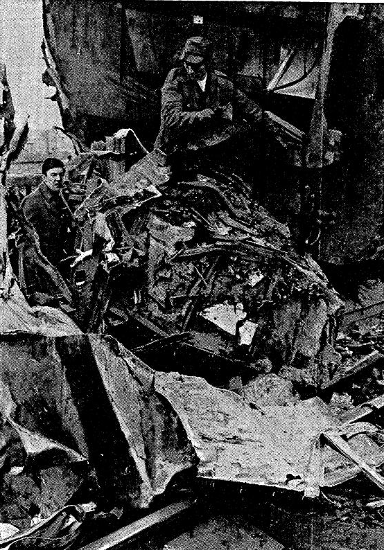
In fact, the main damage came in an awful day time raid on 20 January 1943 when a number of FW190 planes got through defences with indiscriminate shooting at numerous civilians, killing 6 people and injuring 14 others. Each plane had a 500 kg bombs; one of these was dropped at Sandhurst Road School at 12:31 killing 38 children and 6 teachers. Another landed in Woodlands Street 4 minutes later– the impact must have been in the street itself as none of the houses were destroyed, and just 2 injured. The ARP Log notes that the road was closed due the scale of debris and that 66 houses were severely damaged – this included houses in neighbouring streets too.

In some locations where World War 2 damage is easy to spot with replacement houses in a different style or large areas of different bricks used – there were brick shortages post World War Two and it was often to get exact matches. The tell-tale signs are less clear here – in a few houses bricks the red brick detail around square bays of the yellow London Brick Co ‘Stocks’ is missing. But the only really obvious signs are on one house above with different window styles and a missing pointed roof to a bay window. That said, a lot of houses on the street are rendered or have painted brickwork which hides what happened underneath.

The street outlasted the hospital next door which closed in 1997. The hospital site was redeveloped over the next decade or so mainly by Bellway – ‘badged’ as Meridian South (the Prime Meridian passes through the end of Woodlands Street). The Woodlands Street part seems to have been one of the later phases and was developed for a housing association.
Notes
- Godfrey Smith (1997) Hither Green, The Forgotten Hamlet p35
- Kentish Mercury 05 February 1904
- Woolwich Gazette 15 July 1904
- Kentish Independent 11 September 1903
- Kentish Mercury 06 October 1905
- Kentish Mercury 09 August 1907
- Kentish Independent 13 March 1903
- Smith op cit p63
Credits
- The Ordnance Survey map is on a Creative Commons from the National Library of Scotland.
- Census, 1939 Register and related data is via Find My Past (subscription required)
- The ARP Log was accessed via the under-resourced, but always helpful, Lewisham Archives
- The bomb damage mape is via Laurence Ward’s ‘The London County Council Bomb Damage Maps 1939-1945’ published in 2015 – permission has been given by the copyright owners of the map, the London Metropolitan Archives, to use the image here


