Tag Archives: Greenwich Park

In Search of the Greenwich Park Branch – Part 2 –  Blackheath Hill to Nunhead

In the first post on the Greenwich Park Branch we left train approaching the long gone Blackheath Hill station, having  squeezed between the backstreets of Greenwich, as we attempted to follow the remains of the branch line from Greenwich Park.

Before getting our virtual ticket to travel to Nunhead it is worth recalling a little of the line’s history – the railway was a relatively short lived one, built by the London, Chatham and Dover Railway from and existing junction at Nunhead to Greenwich Park. Most of the line opened in 1871 (apart from Brockley Lane station which opened in 1872) but didn’t reach Greenwich Park until 1888.  The line was never a financial success, journeys into central London much slower than from Greenwich and changes often being needed at Nunhead.  The line closed in early 1917 due war time financial savings.  It never fully re-opened, with the section to the north east of Brookmill Park being largely abandoned and the remaining section eventually incorporated into the Dartford to Victoria line.

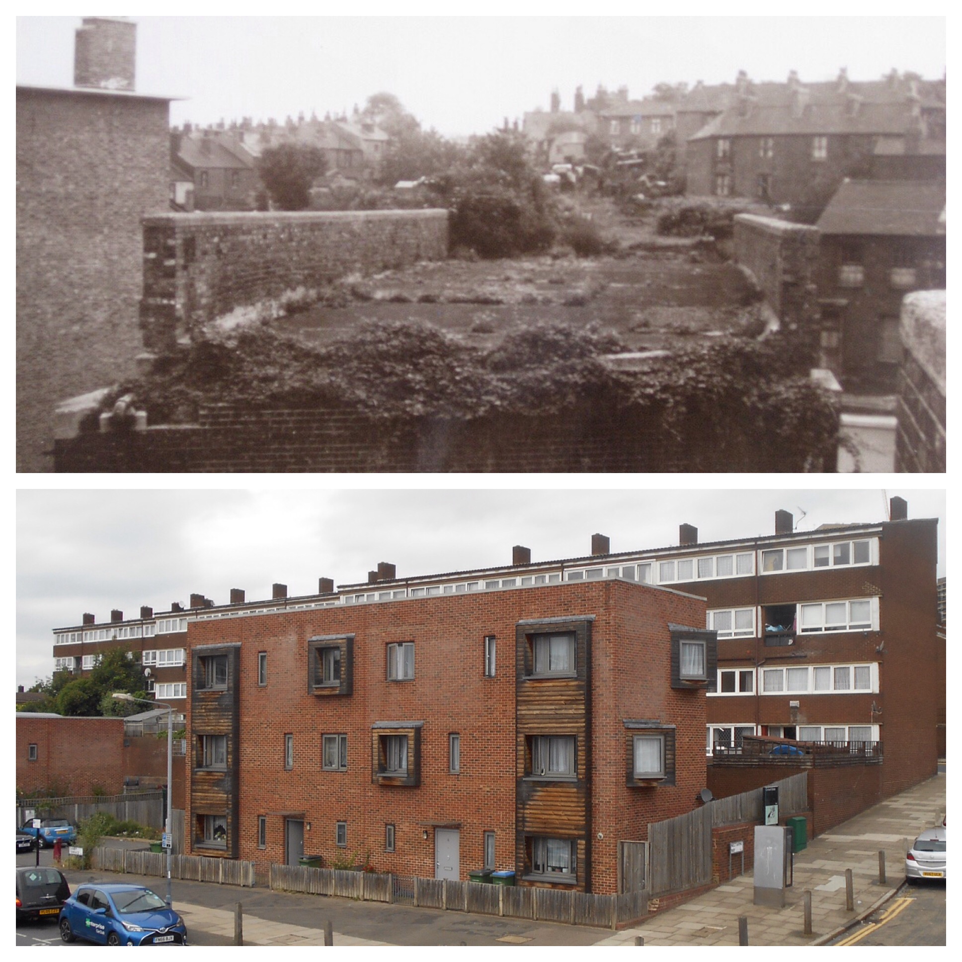
Blackheath Hill (top photo below) was the initial terminus for the line when it opened in 1871 as the London Chatham and Dover Railway struggled to fund the development of the route through the already densely built Greenwich.  After the station closed it became a light engineering works with the tunnel under Blackheath Hill to the station was also used as a factory.

A wall bars the way from Blackheath Hill to the recent infill of Robinscroft Mews (bottom left), it is gated at the Sparta Street end preventing any peeking for unlikely remaining signs of Blackheath Hill Station.

A fascinating recent find at the Greenwich Heritage Centre (see picture credits below) shows plans from the Greenwich Board of Works from 1870 for the next section of the route as it dropped down towards the Ravensbourne.

The railway was in a cutting as it crossed Lewisham Road, but any sign of it in this area to the east of Lewisham Road has been completely obliterated by the 1960s redevelopment of the area through the Orchard and neighbouring estates.  Its route would taken it through Melba Way, touching Morden Mount School and then emerging out onto an embankment to smooth out the dip containing the Ravensbourne.  The upper photo below (see credits below) shows the remains of the bridge over Coldbath Street – along with the current view from a similar location.

The only remains of the time when the Greenwich Branch passed through would be a rather grand looking former pub, the Ravensbourne Arms – which closed its doors as a pub in 2013, on the corner of Silk Mills Pat and Russett Way.  It shouldn’t be confused with the also closed pub opposite St Mary’s Church in Lewisham which was known for most of its life as the Coach and Horses.

The railway would have the crossed the northern end of the platform of the Elverson Road DLR station before passing through Brookmill Park – still on an embankment.  The former railway’s lofty perch is still there through the park and on the opposite side of Brookmill Park in the Brookmill Nature Reserve.

After the tracks were removed in 1929, the land was largely abandoned for 50 years by British Rail, presumably used as an informal play area.  The freehold was bought in 1979 by Lewisham Council and with input from several local groups created the Council’s first nature reserve.  There is a rich varied flora within the reserve.

Beyond the nature reserve, the main line into London Bridge was crossed close to St Johns and the Greenwich Park Branch line headed towards the next station Lewisham Road, the name presumably a shortened version of Lewisham Way’s previous name – Lewisham High Road. Unlike the previous two stations, Lewisham Road is still there – at street level at least the building remains, it is ‘home’ to a salvage and second hand shop – Aladdin’s Cave – whose roof is covered with tarpaulins so may not necessarily be in a great state.

The railway is visible at this point too, crossing again Lewisham Way in a deep cutting, the south western side of the bridge is home to a micro library in a listed phone box – visited in the early days of Running Past.

With a railway visible there is little detective work to be done from here on – the penultimate stopping place is Brockley Lane station – there are two clear signs of the former station – the stationmaster’s house and a gate to some steps up to the platform – below (source eBay April 2016)

The route to Nunhead is largely flanked by Drakefell Road to the north and St Asaph’s Road to the south, occasional glimpses of the railway, deep in a cutting are visible via the roads and paths that bridge it.  

Nunhead Station was the terminus for the line and often required passengers to change train to head into Victoria or St Pauls (now Blackfriars).  In addition to the main line from Catford Bridge and Crofton Park, there was also a line to the Crystal Palace High Level Station (a route that Running Past will no doubt follow one day).  At this stage, when the Greenwich Park Branch Line  was functioning, the station was in a slightly different location – closer to the Lewisham side of the bridge, where Bonita Mews and a plant hire yard are now located (the bottom two photographs below) although there is nothing left of the former location of the station..

Looking back, the decision making relating to the route seemed strange in that it skirted Lewisham and by the time it reached Greenwich Park the neighbouring Greenwich station was already well established and most of the other stations also had rivals from other operators.    Combine this with a circuitous route into central London, often requiring a change it is of little surprise that the line didn’t survive.

Picture and Map Credits


The Hidden Waterways of Greenwich Park

One of the more noticeable features in and around Greenwich Park is a series of (mainly red) brick structures which are clearly several hundred years old – the biggest and most obvious being a large windowless chapel-like building on the western side of the Park at the bottom of the escarpment, close to Crooms Hill.

They are all the external remains of a system of conduits, underground tunnels, which brought fresh water from Blackheath to the Royal Hospital for Seamen at Greenwich.  While there seem to have been earlier conduits for the former Royal Palace (that was previously on the same site), the visible remains date from the late 17th and early 18th centuries.  It has been suggested by Per von Scheibner, that there are at least 12 conduits from this era around Greenwich – although some of these may have fallen into disuse quite soon after construction.  There are elements of three that are clearly visible in the Park.

image


The chapel-like structure is the most obvious element and has a plaque describing it as “Greenwich Hospital Standard Reservoir” and is Grade 2* Listed.  It is generally known as the Standard Reservoir and was probably designed by Nicholas Hawksmoor, who was Deputy Surveyor of Works in Greenwich at the time – he is better known for churches like St Alfege in Greenwich and St George in the East.

image

The other end of the conduit is to the south-west of the Park on the edge of Blackheath – Conduit Head which is on the corner of Hyde Vale (originally known as Conduit Vale) and West Grove.  The information panels at the semi-cylindrical Head and the surface brickwork that feeds it date it from around 1710.  The conduit would have taken water to the Standard Reservoir.  To confuse matters there is another conduit, the Standard Conduit, which also had a small reservoir, immediately above Hawksmoor’s building.

image

Both of these are marked on the 25” OS 1st  edition map, surveyed in 1867, along with rows of trees either side of them known as  Conduit Avenue – the avenue extended from around where the Rose Garden is currently situated to the bottom of the Park, close to the herb garden – it is very clear below the escarpment.

image

From the middle of the escarpment down, along the course of Conduit Avenue, there are a series of other signs that indicate the presence of conduits – several bits of raised brickwork and a number of otherwise unexplained manholes.

image

In the centre of the Park, close to Queen Elizabeth’s Oak, there is an exposed stonework gulley, which looks very similar to that on the edge of the heath, and is a remaining part of another arm of the conduit system in the Park.   Just below it and a little further down the hill are undoubtedly some other remains – a bit of pipework on the surface, a number of manhole covers and some earthworks around the final manhole – perhaps there used to be a conduit arch there.  Above the exposed stonework, there was probably a small pond or reservoir – there is small, flattened area, carved into the top of the escarpment – similar to those on the flanks of One Tree Hill which we’ll now move on to.

image

To the west of the Park there is a conduit arch at the foot of One Tree Hill which is thought to have been built in 1705, probably by Hawksmoor.   The tunnels behind it were found to be inaccessible when surveyed in the mid -1990s; however Subterranean Greenwich managed to gain access, with some great photos.  There were certainly more visible above ground remains in the 19th century – OS Map surveyors noted ‘water receivers’ to the east of the arch on the 1867 surveyed 25” map.

image


A little lower down the hill, nearer to Maze Hill, used to be a pond that was part of the conduit system – the location though is obvious on the ground – a flatter area, banked at the bottom carved out of the lower slopes of the Park.

There are other possible signs of the remains of the conduits in same area – around the eastern flanks of One Tree Hill there is what looks like a slightly raised track going up the hill (which has a couple of manhole covers), toward the top of which it has clearly been flattened out – perhaps there was originally another pond or open reservoir here.  It would certainly have been in the right area based on a map found by Subterranean Greenwich – more on them later.

The tunnels themselves are

built of brick, and are generally about 4 to 6 feet high and about 2 feet to 4 feet wide and generally run between mere inches to some thirty feet or more below ground level. At the top is a rounded or Gothic arch. At the bottom of the conduit walls are gaps in the brickwork to allow water to feed into the conduit.

The conduit system largely stopped being used when the now redundant reservoir was constructed between 1841 and 1844 close to Great Cross Avenue on the western side of the Park.   As a result many of the conduit heads and other above ground evidence was demolished in the second half of the 19th century.

There is a fascinating resource with an enormous amount of information on many of the things covered in this post and on all things below the surface in SE10 and slightly beyond – Subterranean Greenwich (which migrated to WordPress earlier in the year).  This covers the conduits in much more detail, including a lot of the underground aspects of them.


Going Underground

It was a very soggy South London that greeted me this morning, it had been raining heavily all night and while it had eased slightly by the time I started my watch, it was still very wet.

The rain had brought down much of the remaining autumn colour and in places it was like running on a yellow carpet.

Greenwich Park was very quiet just a few other hardy runners, dog walkers some with rather reluctant hounds, although other canines embraced the rain, a few harassed looking parents with hyperactive offspring loving the flooded paths, plus a small number of rather dejected looking tourists who had clearly hoped for better weather on their trip to London.

I did plan the route to escape the rain for short interludes, covered colonnaded walkway to the rear of the Queen’s House, and by the Chapel and Painted Hall at the Old Royal Naval College.

IMG_0526.JPG
I had hoped to have my spirits lifted by students practicing at the Trinity School of Music, I was once greeted by a loud fanfare from them, but this morning the courtyard next to the practice rooms was eerily quiet – rain stopped practice. The rain continued to pour down so, as I skirted around yesterday’s birthday boat, the Cutty Sark, I took an unplanned turn down the steps to the Greenwich Foot Tunnel to get some respite – it was rather surreal running under the river but rather pleasant. The musical accompaniment that I had hoped for a few minutes earlier was oddly provided below the Thames with some beautiful sounds echoing through as a band, with a singer who sounded rather like Elena Tonra from Daughter, seemed to be shooting a video and taking photos – hopefully they’ll keep the image of an orange blur whizzing past (although in reality it will probably look more a plodding packet of Jacobs Cream Crackers).

IMG_0527.JPG

Following the Meridian III – To the Observatory

The last two posts on following the Prime Meridian, went through Bromley’s suburbia and then through Lewisham leaving us at the resting place of several Astronomers Royal at the old churchyard of St Margaret, Lee (albeit a few metres off route).

The Prime Meridian can be picked up again on the other side of the river valley that the railway purloined, that of Upper Kid Brook, at the top of Heath Lane. The ‘line’ goes through the back gardens of The Orchard, but once round that late Victorian incursion into the ‘Heath, the open expanse of Blackheath makes it easy to follow despite some long grass in places.

The Prime Meridian almost cuts through that ultimate eyesore for the ‘guardians’ of the ‘Heath – the Tea Hut, which has been there since the 1920s (It was destroyed in a car crash in early 2020). The Blackheath Society had been trying to get rid of it for at least 40 years through various means, although in recent years they became more relaxed about it re-tweeting details of a film about it. However, it remained limpet like at the junction of the A2 and Goffers Road. It’s not terribly exciting, it’s not that attractive but was always well used and was a bit of a local institution, something that the ‘Heath was, on balance, better for. I often run past, it is by one of the main pedestrian crossings on the ‘Heath, but don’t stop, tea isn’t a drink to be running with…. There are plans to replace it.

IMG_0482.JPG
Along the side of Chesterfield Walk is a meridian marker built into the wall of the Ranger’s House.

P1040367.JPG
Next door used to be Montague House, home to Caroline of Brunswick between 1799 and 1813 which was demolished in 1815. The Rangers House, where Caroline’s mother, Augusta, lived, fortunately remains. The House was bought be the Crown in 1815 and the meridian passes diagonally through it.

P1040369.JPG

Into Greenwich Park and the Observatory is in sight as the Prime Meridian skirts the north western edge of the rose garden and the covered reservoir before ‘passing through the centre of the transit instrument’.

P1040373.JPG
There is one rather attractive marker in the garden at the rear of the Observatory which looks a bit like a gyroscope but is called an Armillary dial and is an early means of telling the time.

P1040374.JPG
I could follow the Prime Meridian another 1.75 miles (as the meridian flies) south of the river as there are a few meridian markers north of the Observatory before it goes out into the Thames then briefly touching the O2 Arena and then finally crossing the river. These include a rather attractive sundial on the line next to the small boating lake that doubled up as a water-feature for the Equestrian events in the 2012 Olympics.

IMG_0458-0.JPG
However, a line on path by the Dome which I must have run over numerous times but never noticed doesn’t seem a great place to finish though – but this would be roughly the route….

P1040382.JPG
I must admit to having baulked at the £8.50 entry to the courtyard, something which was free until 2011, so the destination photos are taken through the wrought iron railings.

IMG_0491.JPG

London Marathon Odds & Rejections

The Virgin Money London Marathon 2015 winter training top of rejection arrived in the post a couple of days ago as I continued my long tradition of failing to get a place via the ballot, it will go well with the wind jacket from 2014. It is not something I am bitter about – I understand the probabilities, it is just disappointing as it my nearest race, well the start is anyway.

The odds on getting a place aren’t that clear as the splits between charity places – around 15,000 a year, international tour places, club places, good for age places, transfers from the previous year places, elite places, and sponsors places are not published; it probably only allows around 17,000 places for the 125,000 who apply before the cut off in the ballot.

I have never had a place through the ballot – I have had a charity place a couple of times, a trio of club places, a couple of ‘good for age places’ (those were the days…), one place for 5 consecutive rejections (a system abolished when Virgin took over the sponsorship) and a ‘bequest’ place – whereby you donate your entry to the London Marathon Charitable Trust in return for going into another mini ballot, if successful you get a place, if unsuccessful you get some reasonable quality training wear albeit with a Virgin Money corporate logo. I’m reasonably happy to do this as to money goes to help fund various community sports projects including bringing former private sector sports grounds into public usage, such as one on Shooters Hill Road.

As I don’t want the hassle of raising around £2000/€2500/$3200 (other currencies are available) for a charity and I had a club place last year, so it looks like I will be looking elsewhere if I run a marathon next spring – perhaps an off road one for a change.

An October 2016 postscript

As there is a spike in viewing of this post around this time of year, no doubt for the same reasons as I originally wrote it, so I thought that an update might be in order.

The odds have deteriorated significantly since I wrote the original post, the ballot entry is now open for several days, rather than closing when 125,000 reached – 253,930 applied for the around 17,000 ballot places for the 2017 race – giving a 1 in 15 chance of getting a place.

Unsurprisingly, given the odds, I have had two more rejections – I now have a half marathon’s worth of ballot rejections. My family can add to this, in the last three years my children have put in five applications, all unsuccessful.

I have even given up with the ‘bequest’ – I added to my London Marathon branded winter tops last year – but there really is a limit to the numbers needed, so I’ll give the money I have saved this year to charity through a different route.

I had planned to run the inaugural Ashford Marathon in April 2015, but any thoughts of this went by the wayside with a serious accident.  I wasn’t sufficiently recovered in 2016 to think about marathon running but may try and build up fitness for one during 2017.

2018, 2019 & 2020 London Marathon Updates

There were a ‘world record’ 386,050  applications for a slightly increased 17,500 ballot places so predictably my application came to nothing – a roughly 1 in 22 chance of a place in 2018.  The slight increase in available places appears to have come through increasing the capacity of the course by starting runners in waves – my own experience of this in other races is that for the mid-paced runner it slows times as more distance is covered weaving in and out of slower runners.

Nothing different happened with the 2019 ballot which no longer even guarantees Good for Age Places, and a reduction in the number of club places available.  414,168 applied for the 2019 race giving a roughly 1 in 24 chance of success – the e mail of commiserations dropped into my inbox in October 2018.  There was a family success though – my son defied the odds and got a place for 2019 – it was our family’s combined 19th attempt to get a place through the ballot – sadly, injury prevented him getting to the start line, but he’ll be transferring to the 2020 race.  I’ve entered that too, when the ballot opened on 29 April 2019, but the odds are stacked against my participation through the ballot.

When doing the 2019 update, I realised that I could have been a little pessimistic in terms of the odds.  The oft quoted 17-17,500 figure of places in the ballot isn’t clear whether it is for those who make the start line or places offered the previous October.  If it is the latter, it is as previously described.

However, if it is the start line, the odds change as the organisers’ offer more places than they know will actually start as there is a relatively high dropout rate before the race starts – a combination of injury and those with places finding the reality of training throughout a dark, wet and/or cold winter just proved too daunting.  I deferred a Good for Age place on one occasion due to injury.     It has been suggested that the numbers of places offered for 2019 were around 55,000 with around 42,750 making the start line.  If this is correct, that would suggest around a 13% drop out rate.

Assuming that the proportion not reaching the start line is similar in each group, the 17,500 ballot starters would originally have been part of a cohort of 19,807.  There would be a 4.8%, or 1 in 21, chance of getting a place; not much better, but slightly less daunting.


Greenwich’s Books About Town Benches

I stumbled across one of the benches a couple of days ago when running through Greenwich Park, despite having passed several others over the summer I had contrived to miss them. They are dotted around Greenwich and the Park and are a good mixture of adult and children’s fiction and many have links to South East London.

Books about Town is being promoted by the National Literacy Trust with Wild in Art. There are four trails of benches around London, all are shaped as open books, decorated by professional illustrators and local artists. After the trails close in mid September, all the benches will be auctioned to raise funds for the National Literacy Trust’s work to raise literacy levels in the UK.

Being Greenwich there are some fantastic backdrops (and in many cases backs) to the benches …..

IMG_0409.JPG
Clockwise from the top left
– Michael Rosen’s “We’re Going on a Bear Hunt”
– Rudyard Kipling “The Jungle Book”
– Charles Darwin’s “Origin of the Species”
– Captain Scott’s Autobiography
– David McKee’s “Elmer the Elephant”
– H G Wells’ “The Time Machine”

IMG_0407.JPG
Clockwise from the top left
– Sue Townsend’s “The Secret Diary of Adrian Mole : Girl Engrossed”
– Dr Samuel Johnson’s Dictionary
– Samuel Pepy’s Diary
– Chaucer’s “Canterbury Tales”
– E Nesbit’s “The Railway Children”
– Douglas Adam’s “The Hitchhiker’s Guide to the Galaxy”

IMG_0408.JPG
As for the local links, they include – E Nesbit lived in various homes in Lewisham before moving to Eltham (there will be a blog post here on her later in the year); H G Wells was born in Bromley and was a regular visitor to Nesbit’s home at what is now Well Hall Pleasaunce; Darwin lived in Downe for many years; Pepys lived in Deptford; Michael Rosen is Professor of Children’s Literature at Goldsmiths’ and, finally, Elmer the patchwork Elephant clearly inspired the cladding for Lewisham’s new Glass Mill Leisure Centre.

As for my favourite – it has to be “We’re Going on a Bear Hunt” – both because Helen Oxenbury’s simple illustration works well as a bench and in its location -next to the pond and close to large rhododendron bushes in the Flower Garden – it is possible to envisage a parent with a degree of imagination acting out the story with their children in the park; but most of all, I liked it because it brings back happy memories of reading the book to my children when they were younger.

P1040138.JPG

Back on the Road

It seems a while since I have posted anything about running, but that’s because I haven’t done much due to illness. I started getting night fevers in Paris ten days ago and they seem to have taken an age for my body to shake off. I even looked up to see whether I had any of the symptoms of the Ebola Virus, I didn’t, but after careful research narrowed it down to man ‘flu, menopause or an allergic reaction to 1970s John Travolta musicals – probably the first though.

So this morning, it felt great to be running again, albeit not very far or fast; it was one of those good to be alive runs – it was sunny, the views from The Point on the edge of Blackheath were almost perfect and there was still a lot of late summer colour in Greenwich Park’s Flower Garden – some Begonias and Rudabekias caught my eye.

IMG_0404.JPG

A Bad Week For Running, But a Mystery Solved

After a winter largely free from illness, the first signs of Spring brought a sore throat, sneezing and a couple of days fighting off a temperature, and as a result, no running for 6 days.

This morning’s easy paced come-back run was in near perfect conditions, a sunny 14°C and lots more flowers out in Greenwich Park.

20140309-130047.jpg

20140309-130224.jpg

With less time spent running this week, I have had a bit more free time and one of the things that I used it for was prompted by an interesting post on the Thames Facing East blog which provoked some discussion between us about the Upper Kid Brook. It got me thinking about the course of Middle Kid Brook and where it joined the Quaggy.

The answer is that it doesn’t. Something on a map on the Ideal Homes site (see below), a run through the Cator Estate, some poking about in some undergrowth with the resultant ‘what on earth are you doing’ from the bemused owner, followed by an interesting conversation with her, confirmed that the Middle Kid Brook doesn’t just disappear off the map, it disappears into a ‘sink’ between Lee Road and Park Gate. I will probably do a bit more on this in the future, as there are several other places where the remains of the Brook are just about visible.

20140309-130800.jpg